Good Friday, folks. We are rolling into the weekend with heat and humidity kicking back in, but it’s not here for the long haul. A wet and stormy pattern is taking shape for next week and that’s going to keep our temps much cooler for the final week of July.
Before we get to that stormy setup, let’s focus on the heat rolling back in. Here’s the breakdown…
TODAY
- Temps reach the low 90s east with middle and upper 90s far west.
- Humidity levels make it feel 95-100 east and 100-105 west.
- There’s a small chance for a popcorn shower or storm.
SATURDAY
- Highs reach the mid 90s for much of central and eastern Kentucky.
- The west makes a run at 100 degrees.
- Heat index values are firmly into the danger category across the west with a heat index of 110 or so for some. It’s a little cooler east.
- There’s a better chance for a few storms going up and we have to watch for a complex of storms making a run at us from the northwest.
- If that complex of storms does fire up, temps will be down a bit.
SUNDAY
- Temps are similar to the Saturday numbers but may come down just a touch.
- The heat index is still in the danger category.
- Some showers and storms fire up late in the day.
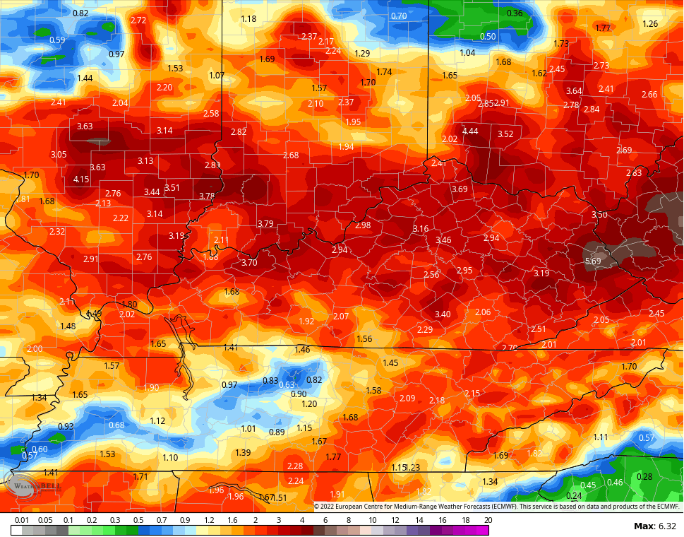
A front drops into the region by Monday and Tuesday and it then slows down. That boundary likely hangs around all week long and is likely to give us a heavy rain and strong storm setup. The GFS shows these rounds of storms very well…

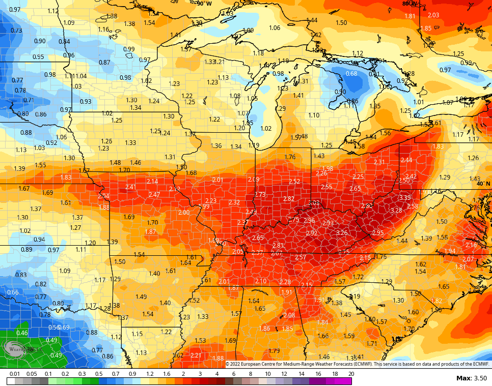
We really need to be on guard for flash flooding issues in a pattern like this and the models are picking up on this potential. The EURO has some eye-popping totals during this time…
The average of the 51 member EURO Ensembles is really wet…
The Control run of the EURO Ensembles are even wetter…
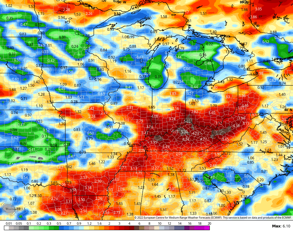
Again, this is a setup to watch closely.
Have a great Friday and take care.

That heat index of 128 was crazy…. I remember reading something about dewpoints and humidity are not as high in the mountains. Back where I grew up in western NC….it was humid…but I don’t ever remember being under any kind of heat warning.. and when I look up the national dewpoints they are always lower in the mountains…I’m not sure what the highest dewpoint I’ve seen here in Lexington I think was 79…but I think the record was 80 or 81
I visited a beautiful village many years ago located high in the Blue Ridge Mountains and the climate there was perfect in every month. Springs were abound with many Rhododendrons and native Azaleas in full bloom. Summers were not hot and humid and local Folks said the high temperatures usually stayed in the 70’s. Autumns were cold and frosty with plenty of color on the hardwood trees. Winters were moderately cold with tons of Snow.
I concluded that if you visit a town in the Spring months and Rhododendrons and native Azaleas are present that is the prefect climate to retire. I must say I ” miss the boat. “
When I was out in the Pacific Northwest, Oregon to be exact, we visited a Nursery that grew all Rhododendrons on the Pacific Coast. Temperatures were in the high 50’s and the humidity was 100% in the middle of the day with full Sunshine. The dew point was around 40 degrees. A very comfortable climate. It’s the dew point plus the temperature that make it feel comfortable.
Here’s the latest on ENSO. Right now doesn’t look good for we Snow Lovers. Subject to change though.
https://www.climate.gov/news-features/blogs/enso