Good Sunday to one and all. Thunderstorms caused more flooding issues across the state on Saturday, but the action shouldn’t be as widespread today. Unfortunately, more storms are coming at us in the week ahead and those may cause more issues before calm and cool changes work in.
Let’s begin with today and roll forward. Highs are deep into the 80s with a 90 in the west. Scattered showers and storms will go up again during the afternoon and evening, but we won’t see the same coverage of the past few days.
Here are your radars to follow along…

Monday features more of the same with similar temps and scattered storms.
A cold front then drops in from the northwest and slows down Tuesday and Wednesday. This will bring an increase in showers and storms that will likely take us through Thursday before we can get this front to finally sink to our south on Thursday.
These waves of showers and storms may bring more high water concerns…

That front is also being pushed by a September feeling air mass settling in for the end of the week into the weekend. The GFS is actually keeping our temps below normal into next week. Check out the 7 day departure from normal…
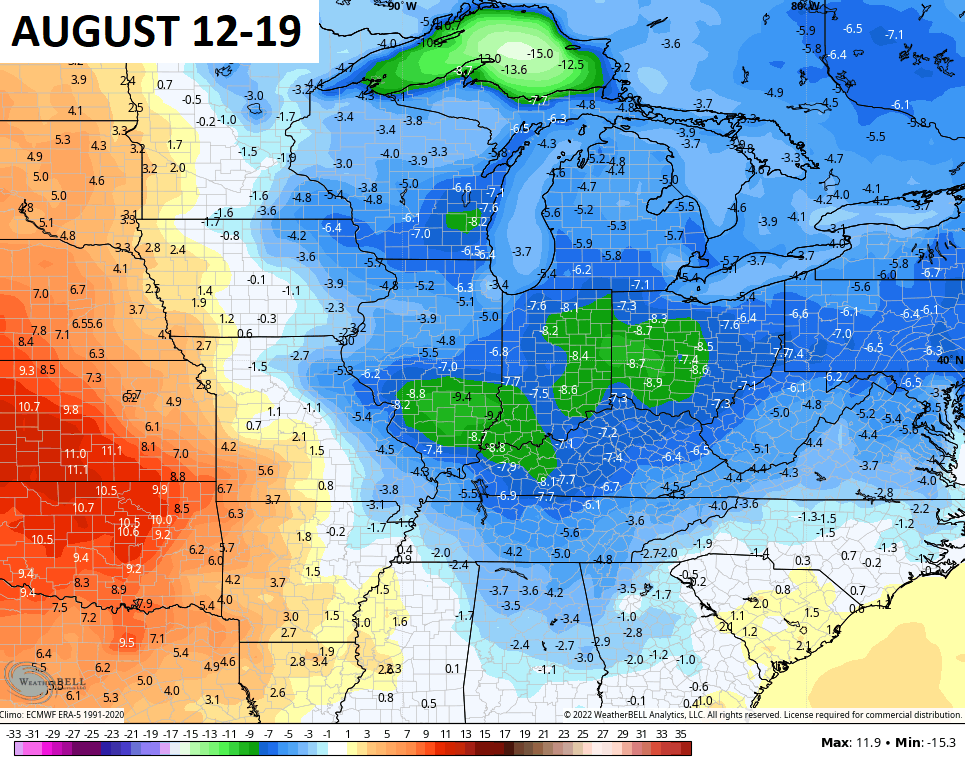
Saturday morning lows dropping into the low and mid 50s? Yes, please…

Have a sensational Sunday and take care.

Sounds good to me. We normally see a few cool nights in August, so it’s all good. 😉
I am SO ready for a change from this relentless heat “heat & humidity!” At 12:30pm CDT this afternoon, the temperature at my PWS near Bowling Green
reached 93.2°F, the Dewpoint was 81.5°F, and the Heat Index hit 115.3°F.
At 2:00pm, a thunderstorm put down 0.66″ of welcome rain. It was beneficial for burned-out lawns and dried but only succeeded in pushing the Dewpoint over 80°F. AGAIN!
Dewpoint He!! Everything is SO green here in Lexington….For a while our lawns were burnt too…but that’s all changed from the last few weeks of rain…We did have storms yesterday with some loud thunder.
Not bad at all. I will take it.
Thanks Chris, yesterday we received 1.35 inches of much needed rain. The most we’ve seen in a single storm since this active weather pattern started last month.
I’ve been living here for 14 years and this has been the most humid Summer I can remember. I’ am hoping for seasonal changes soon ?
The Tropical Atlantic is beginning to get active.
The high temperature Saturday at Chicago’s O’Hare Airport reached a hot, muggy 95 degrees, the hottest temp since June 21st.
A steady, soaking rain is covering much of Northern IL and the Chicago area this morning, giving much-needed beneficial rainfall.
It’s 7:00 pm central time at my home place tete in far western ky. Right now enjoying a nice breeze and comfortable air believed or not. Have a great evening and we shall see what tomorrow brings if God let us see the light. God Bless to all!