Good Tuesday to one and all. It’s another absolutely amazing weather day across the Commonwealth with cool temps and clear skies. This cool fall wind that’s been blowing since Monday has another day or two left in the tank before we turn the temps up just in time for the upcoming weekend.
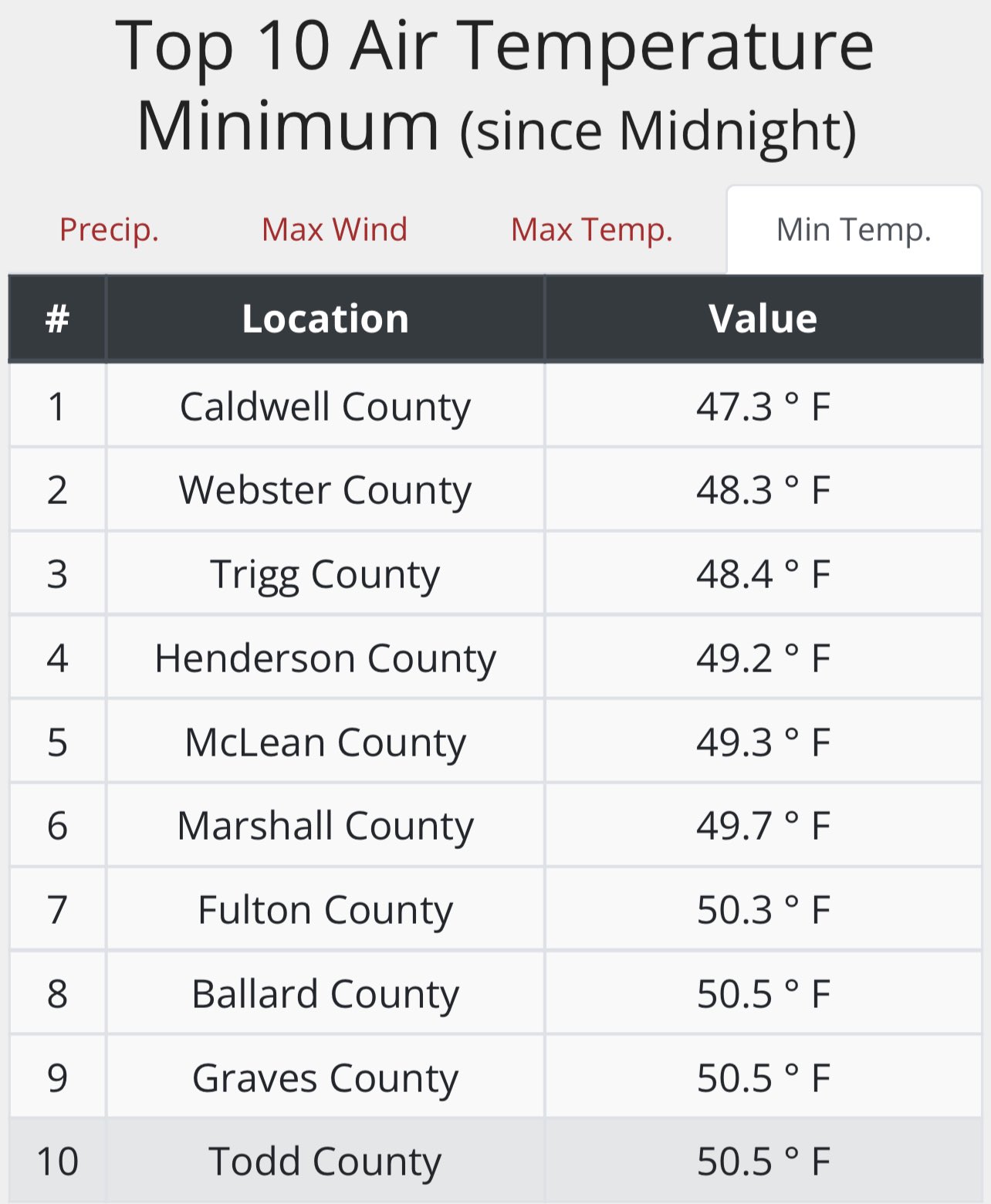
Monday morning brought our first true dip into the 40s for lows across western Kentucky…
Lows this morning may drop into the upper 40s across parts of central and eastern Kentucky, but skies have to be totally clear for that to happen. By the afternoon, temps climb into the 70-75 degree range for many in these same areas.
Humidity levels are low and that’s a trend that takes us through the rest of the week, even as temps do slowly climb. By Friday, most of us are 80-85 for highs and that looks to be a common range for our thermometers to hang out in over the weekend.
This comes with a dry pattern that looks to last into early next week…
You can see the busy look off the southeast coast and Gulf of Mexico with a big fall front working across the plains states. How all that works itself out remains to be seen and will have a big impact on the overall pattern.
If we turn to the Ensembles for answers, we find them hanging on to an overall ridge into next week before breaking it down with a trough…
GFS ENSEMBLES
EURO ENSEMBLES
September is a transition month and that makes it among the most fickle of all months when it comes to weather.
Have a great Tuesday and take care.

Looks as though the tropics have gone back to sleep, the Hurricane Center’s seeing two waves, but both are indicated as having a less than 40% chance of development. Mid-September is traditionally the peak for hurricane activity, especially so in a La Niña year, but as with many factors this year, we’re seeing the exact opposite. The latest SSTA is showing areas of cooler than normal water in the Atlantic’s Intercontinental Convergence Zone, which may be one reason for the lack of development. Shear is not a factor currently, and steering winds are relatively light.
The SSTA In the Pacific is relatively unchanged, with cooler than normal equatorial waters that are reinforcing the current La Niña. Confidence continues to grow that we will see a rare triple dip La Niña this Fall/Winter.
Saharan dust in the upper atmosphere may still be responsible for the lack of Tropical activity in the Atlantic and the Caribbean Seas ? This has happened before, but it’s usually early in the season.
With La Nina’s third year of rein in the Tropical Pacific, what may we expect for the Fall and Winter ? My guess with the AO and NAO not becoming very very negative early in September and overriding this strong La Nina that the Fall and Winter will continue to be the typical ” mild and wet ” here in Kentucky with maybe a few episodes of Winter weather later in the season ?
I’ve experience those low temperatures as highs in September before with frosty mornings, but that occurred many years ago.
In my local forecast this morning they are forecasting high temperatures in the low 90’s for the end of the month ! With no precipitation mentioned ! I’m sure this will change. I HOPE !!!
I think that some of those90° forecast readings are due to some local weather forecasts relying predominantly on the GFS, which has shown a high temperature bias for most of the year. My local forecast app was showing something similar for several days, but is now indicating upper 70’s to low 80’s at month’s end, with lows in the mid 50’s.
Upper 70’s to low 80’s with lows in the mid 50’s is perfect weather, but it still doesn’t feel like Fall to me or to the trees about to go dormant. The Fall foliage color could be great because the sugar content in the leaves is higher this year because of the below normal rainfall, but if the temperatures stay warm it may effect the brilliance of the Fall foliage or even delay it if we get too much rain. We need those moderately cold, frosty mornings to get the best Fall color in October. Hoping this will happen along with a major change in the current weather pattern ?
Here is the link for the summary of the heavy rain/flash flooding that parts of the Chicago Metro area experienced on Sunday. The NWS Forecast Office in the SW Suburbs received 2.20 inches of rain, while O’Hare Airport received 1.95 inches. https://weather.gov/lot/2022sep11
On the rainfall map, Soldier Field near Downtown Chicago is in the area that received between 3 and 5 inches of rain. If you were watching the Bears game against the 49ers on Sunday, you saw the steady rain that was occurring throughout the game which turned into an absolute monsoon in the fourth quarter! At the end of the game, the Bears celebrated their win with some of their players running and sliding head-first on the soaked turf like it was a slip-and-slide.
That upper level low really did a number on Chicago. I wouldn’t want that much rain now, but we sure could use an inch and much cooler weather here in Kentucky.
I watch the game and what a nasty mess, but still the game was enjoyable.