Good Sunday, folks. We continue with gusty winds as the remnants of Hurricane Ian pull well away from the region. As we look toward the week ahead, we find more in the way of awesome fall weather before a blast of cold air works in.
That blast will put the growing season in jeopardy by next weekend into early the following week.
Let’s begin with today and roll ahead.
Highs range from the 70s west and 60s east as clouds keep the numbers down a bit. A few showers will also linger, especially early on. Whatever is out there will show up on your radars…

The weather from Monday through Wednesday looks absolutely awesome. Daytime highs range from the upper 60s to middle 70s with overnight lows into the low and middle 40s. There’s a chance for a couple of upper 30s to sneak in from time to time, especially Tuesday morning…

A potent fall cold front then arrives on Thursday and may produce a few gusty showers with it. The big news will be the colder than normal air behind that from Friday through early the following week…

That could very well end the growing season around here and the GFS continues to spit out temps dropping below freezing…

We are also getting close to the time of year when folks like to talk about cold and snow, and all things winter. So, let’s do just that.
I’m leaning toward more of a front loaded winter and that would buck the trend of recent years when most of winter happened in the second half. How early can we get things started? I’m not sure about that, but I do expect our first snows to fly before Thanksgiving.
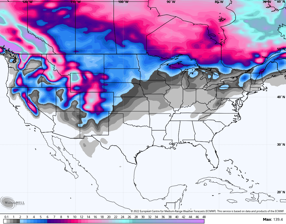
The latest run of the EURO Weeklies seem to be going in on this potential. Here’s the snow map from now through November 13th…
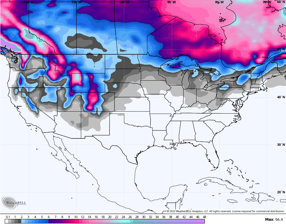
The GFS Extended Ensembles only go through November 3rd, but also show something going on…
Many years have featured October snowflakes around here and we had nice run of those in the 2010s. I’m not sure that happens this year, but we shall see.
Make it a great day and take care.

I wouldn’t complain one bit if winter was front loaded.
Front ” Loaded Winters ” often results in an early Spring with an early Severe Weather Season around here. The Snow maps presented are consistent with a typical La Nina which is now strengthening more so than in earlier forecast. The PNA is weakly positive and the NAO is neutral to slightly negative. Signals at this time point to our usual Fall and Winter here in the greater Ohio Valley, but maybe an uneventful and on the Mild / Dry side like our Neighbors to our South experience in La Nina dominated Fall and Winters ?
Here’s a great explanation as to how our Fall and Winter may unfold :
https://www.weather.gov/iwx/la_nina
Interesting article about the Volcano eruption earlier in the year and what if any any effect on this winter..Also recommend reading article about La Niña..
https://www.severe-weather.eu/global-weather/cold-anomaly-stratosphere-polar-vortex-volcanic-cooling-winter-influence-fa/
Excellent article. The Volcanic activity may be the blame for our cooler than normal temperatures here lately. I don’t have any idea how this recent Volcanic eruption will override the current strong La Nina, but who knows ?
If there is one consistency regarding our weather, it is that our catalog of “normal weather” is, for lack of a better term, obsolete. The watchword these days is extremes. Signals that in the past could help predict seasonal trends and conditions are becoming less reliable in the long term, and more suited to forecasting several weeks out. Even forecasts based on analog years present more of a challenge, especially in a year like 2022, which for many cases, does not have any clear-cut analogs. There are many examples this year where there has been a wide divergence between what forecast models see down the road versus what actually occurs (I’m talkin’ about you GFS!). Climate change is rewriting the “book” on forecasting.
That’s so true Joe. The Climate World Wide is getting difficult to predict due to unseen Natural Factors. Maybe someday we will learn why, but not in my lifetime. I learned this morning that we were in an El Nino from 1950 to 1979. No wonder there were so many Snowy Winter during that time period of my life. I also learned that the Azore High or Subtropical High Pressure in the Eastern Atlantic which is responsible for Europe’s Wintertime precipitation is becoming less and less due to the Westward expansion of the said High Pressure System. I’m sure that change is affecting the World’s climate also.