Good Friday, folks. We’ve made it to the end of the week and we have some windy and gorgeous weather on tap for the weekend. This nice weather comes with a price as the risk for brush and forest fires is very high. We need some rain and there’s some on the way early next week.
Let’s start out with what’s going on today. Temps range from the middle 60s to low 70s on a gusty west and southwest wind. That wind will continue to crank into the weekend as highs reach the 70s with a mix of sun and clouds.
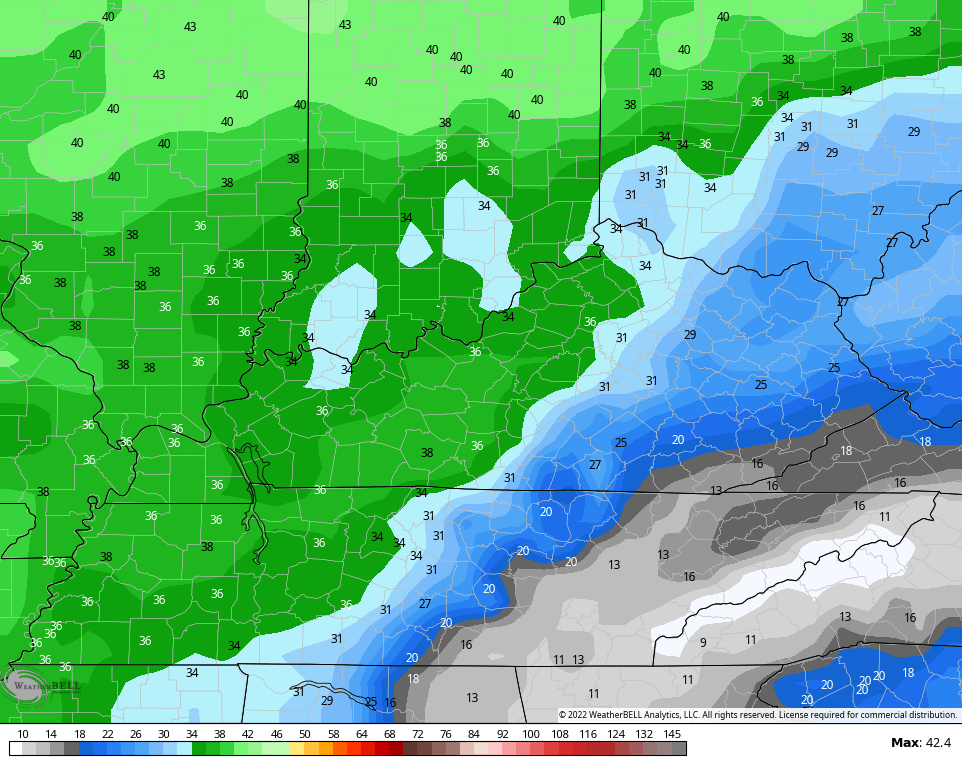
Wind gusts over the weekend may top 30mph at times, especially during the afternoons. Here are the peak wind gust forecasts through Monday…
The storm system rolling our way next week is slowing down in terms of the arrival time. The best chance for rain from this now appears to be late Tuesday into Wednesday as low pressure works through here. That would be followed up by another storm system by next weekend.
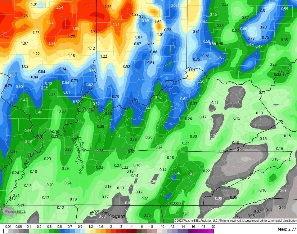
Here’s how the EURO sees this playing out…

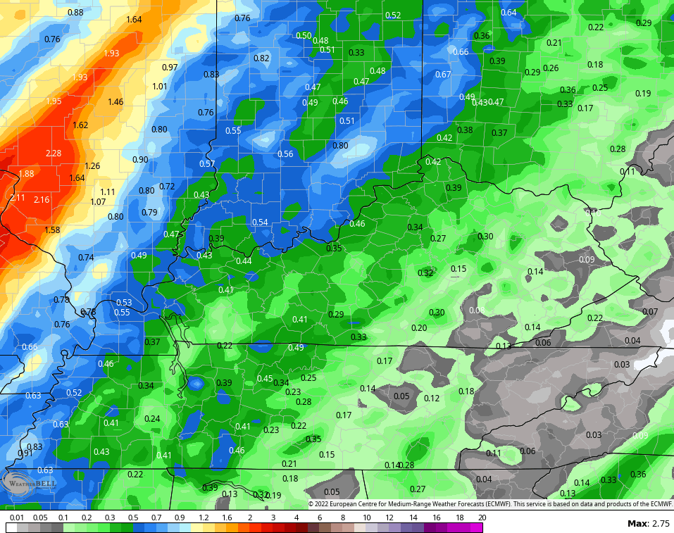
And the GFS…

We need the rainfall and both models are spitting out some decent rains with those two systems…
GFS
EURO
The Canadian has the heftiest totals…

We will talk a little winter over the weekend so be sure to check back.
Make it a fantastic Friday and take care.

@ 1:49 am Est I just looked at the national radar and was surprised to see No Precip across the entire lower 48 aside from a couple of light showers in Montana
Indian Summer is on the way, which is part of our normal weather pattern. Being without rain this long is very unusual. The Tropics are currently quiet and still there’s no organized rain or snow systems anywhere in the entire country. In my local forecast their calling for very little chances for any precipitation the next fourteen days. This current moderate / exceptional drought very well could be this Country’s next natural disaster, but lets hope not.
Maybe when La Nina’s effects kick in this Winter we will return to a more mild and wet pattern or a cold and snowy one ?
The Creator is possibly angry.
Fire potential across South Central Kentucky remains extremely high, and although winds should subside a bit today, they will continue to remain gusty. A bigger concern is relative humidity, which dropped to 23% yesterday afternnon at my PWS. Combining those factors with an abundance of dry leaves adds up to a serious wildfire potential, and with no “serious” rain potential over the next two weeks, drought conditions will continue to deepen.
There’s some interesting speculation on the upcoming Winter in Judah Cohen’s latest blog:
https://www.aer.com/science-research/climate-weather/arctic-oscillation/
The NAO is forecasted to trend positive over the next few weeks the Pacific is more challenging. The La Niña supporting colder water in the equatorial region remains in place, as does the much warmer than normal water in the Northern Pacific. During the past few Winters this 2armer water was centered in the Gulf of Alaska, and supported ridging that pushed the jet stream over Alaska much further north. As it dipped down over Central Canada it dragged polar air down in to the East Coast and Midwest, but this year that warm water is much further west, which if it follows form, should result in cold blasts into the Midwest and the High Plains. However, I haven’t found any analogs for this setup, so we have another climate change-driven anomaly to chew on!
https://www.ospo.noaa.gov/Products/ocean/sst/anomaly/
Thanks Joe for sharing, very interesting information on the upcoming Winter. I listened to NOAA’s virtual outlook for the upcoming Winter and they are predicting a ” typical La Nina Winter. ”
A moderate La Nina that will give our area mild and wet periods through the Winter months ( December- February. ) What is interesting is that the storm tract could be further West in the Appalachians. That may bring snowstorms to Eastern Kentucky or it could keep all of Kentucky in the warm sector if the tract is to Kentucky’s west.
If the NAO goes well into the negative, we all could have a Winter to remember. No one to date has the ability to accurately forecast the Fall and Winter. The forecast just gives us a clue as to what may occur.
Thanks Schroeder, I think that the word “typical”, when applied to weather has lost much of its importance, and has been replaced by the word “extreme”, courtesy of climate change. The farther west storm track could definitely be a feast or famine deal, with the feast highly dependent on a negative NAO. Lately, the NAO has been swinging like a yo-yo, but a yo-yo whose swing is confined to a very narrow arc. In other words, it, like everything else weather-related these days, has a mind of its own.
I do not envy Chris trying to put together a Winter forecast this year, especially in terms of finding reliable analogs to this wacky year!
Joe, I agree the terms have change over the years. They are watching the NAO which is going to neutral to slightly positive and back to negative. I wish it would make up it’s mind…. LOL
The drought will likely end according to NOAA’s outlook for the Ohio Valley. For the West not so likely ?
Right, one can’t rely on analog years anymore for long ranged predictions. The climate has definitely changed to make it more difficult to predict.
Here is NOAA’s official winter outlook for the country, which was just issued on October 20th.
https://noaa.gov/news-release/us-winter-outlook-warmer-drier-south-with-ongoing-la-nina
Thanks Mike for posting this Winter information for me and for others on the blog. I already read and heard the discussion early this morning. I wasn’t surprised by the report on their prediction. I think the Great Lake States will see a lot cold and snow with this third La Nina ? Take that with a ” grain of salt ” just my gut feeling.