Good Friday, folks. We are closing out a cold week and heading into an even colder weekend as our Mid-November deep freeze continues. Now we get to focus on the all important Thanksgiving week forecast and it’s one that can become challenging.
For those who missed the winter forecast last night on WKYT, never fear. I have you guys covered: The Winter Forecast
Let’s start with today as we do have a weak front sliding through. This has very little moisture with it, but it can still spit out a few pockets of light snow and flurries. The best chance of that is across the north and east. I can’t even rule out some very light accumulations for some. Of course, your radars are on duty…

Take that interactive radar on a trip to the Buffalo, New York area where several feet of lake effect snow will fall through the weekend. You may even see some live storm chaser cams from within the heavy bands.
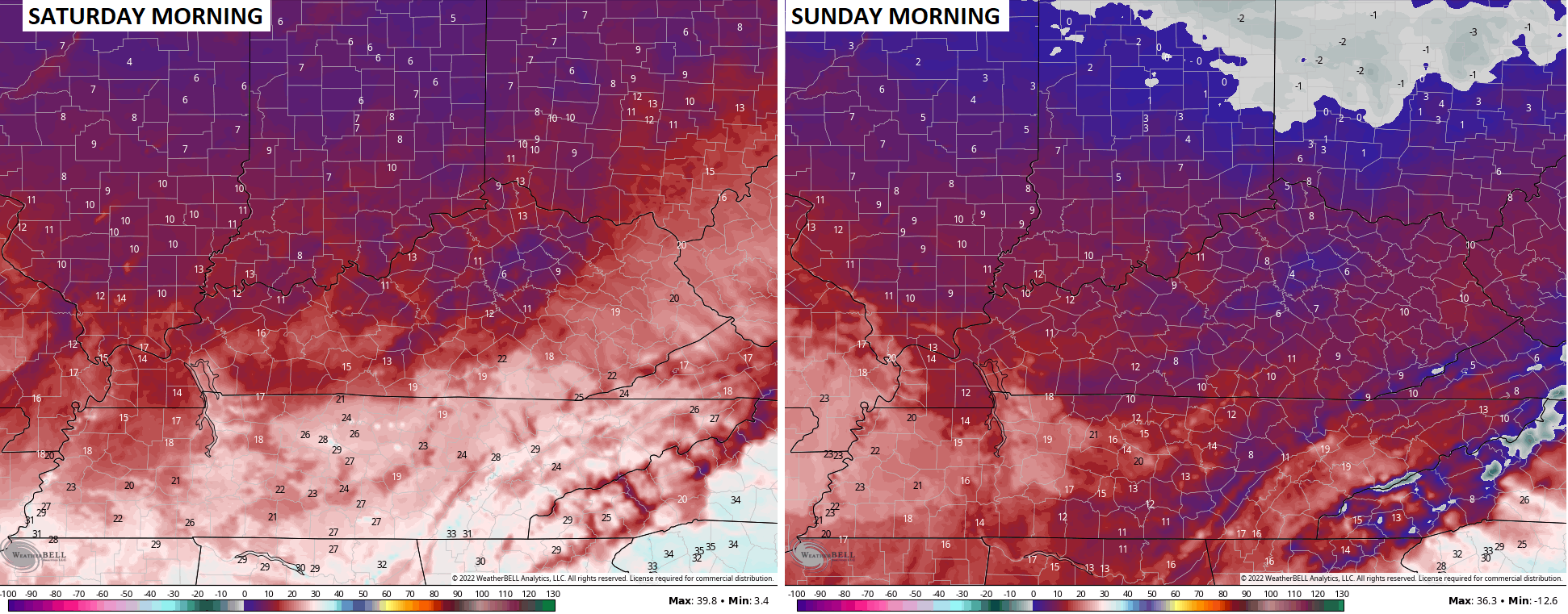
The big story around here is the frigid air. Overnight lows this weekend and Monday drop into the teens for most of the area. Sunday morning has a chance to spit out some low teens and that’s incredibly hard to do this time of year. Highs are in the 30s.
The winds will make it feel even colder with wind chills reaching single digits for many over the next few mornings…
The model struggle is real for the system coming at us over the long Thanksgiving holiday weekend. That said, the models are doing exactly what I said they would and that’s show wild swings from run to run.
The latest GFS pulls a 180 from its prior run and now shows more of a northern stream dominated setup…

The end result is systems diving in from the northwest without much deepening…

Two of the biases of the GFS are at play here. It likes to jump on northern stream energy too much and is too progressive with systems.
The GFS Ensembles look much deeper with this trough in east…

That would certainly argue for a hefty storm system.
And now the EURO has gone back toward a much bigger system in the east…

And check out this big storm…

Again, my thought process on this remains unchanged. We likely start out with windy and wet weather before colder air crashes in with the chance for flakes later in the weekend.
Updates coming your way later today, so check back. Make it a good one and take care.

1st.
After this unseasonable Arctic intrusion, I’ll be ready for a mild Thanksgiving Day.
Chris made a unusual bold prediction last night during his winter outlooked he predict we may have a blizzard this winter. We haven’t experience one since the infamous one on January 1978. But he also quotes since he started making bold predictions 10 years ago, he’s only been right 5 of the 10 years of making such prediction. This will be interesting how this unfolds this winter.
In 1993 there was a huge storm that shut down Southern states. Was Kentucky in on that one? I was living in Georgia then.
YES, 22 inches of Snow reported in London, Kentucky. Here’s the details on the Blizzard of 1993 :
https://en.wikipedia.org/wiki/1993_Storm_of_the_Century
The last Blizzard that occurred in the Ohio Valley was on December 8 th, 1917 during La Nina’s rein. I may be incorrect on this however. The Blizzard of January 25 th, 1978 occurred in a El Nino year. Certainly cold enough now for a good Snowstorm, but we need the moisture for that to happen.