Good Sunday, everyone. A touch of winter is pushing across the region today and Monday, kicking off a busy week of winter weather. This includes the increasing potential for a winter storm to impact us by the middle of the upcoming week.
Let’s get started with the system out there today:
- Rain and snow move in from the southwest before daybreak today.
- A touch of freezing rain can’t be ruled out in a few spots, especially in a few of the colder valleys.
- The best chance for a band of light accumulating snow is along the Ohio River, with the greatest potential in the Covington/Cincy area.
- A cold rain with some mix is likely for many, but a few pockets of light snow may put down a little slush early on.
- Wraparound light snow will kick in Sunday night and Monday. This will impact central and eastern Kentucky and may even cause a few delays Monday morning as light accumulations show up.
Here’s the Last Call For Snowfall through Monday…

Here’s what you need to track today’s messy system…

Go to our weathercams page to check out the winter views from across the state…
The next system coming in Tuesday night through Thursday has the look of a Winter Storm Threat. I’m not pulling the trigger on that just yet, but I very well may do so later today. Here’s the initial look at the area most at risk…
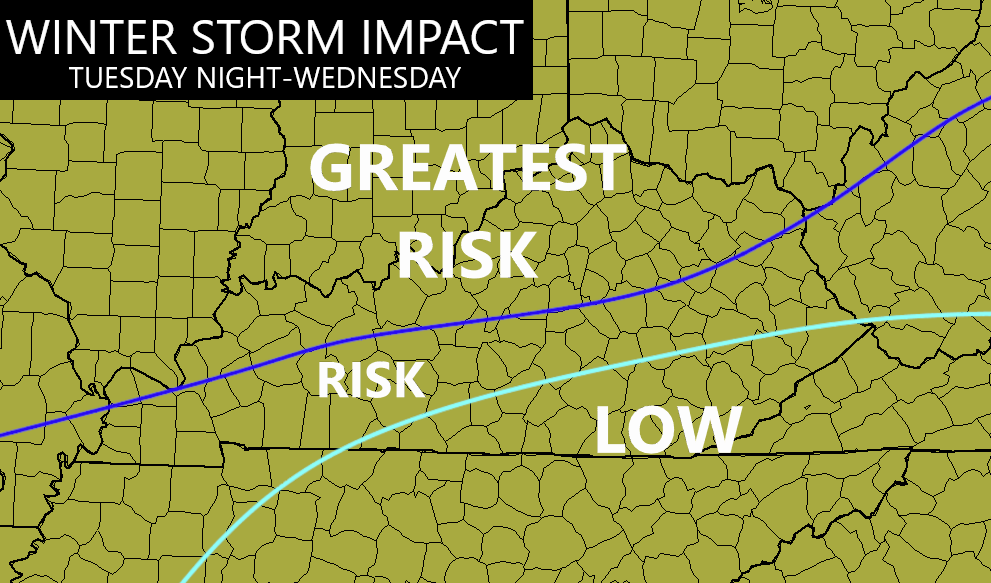
This is a significant winter storm that will impact areas from Texas to New England. The exact track of the low will be the determining factor on how much impact in has on where you live, but the map above shows my areas of concern.
This looks like one of those fence riders setting up on top of Kentucky, but with a colder high to the north of us than what we have out there today. As the low goes by, we find a hefty wraparound snow for the entire region into Thursday and snow showers going into Friday.
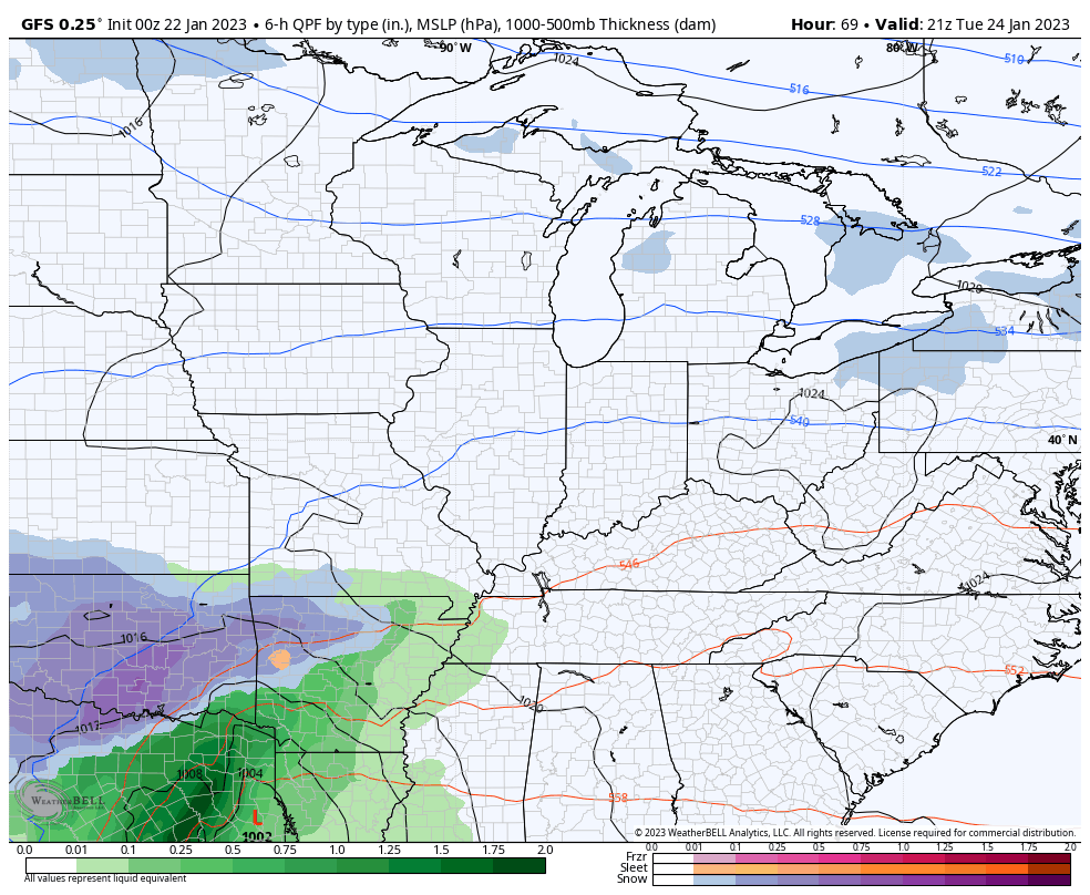
Here’s the GFS with this storm…
EURO
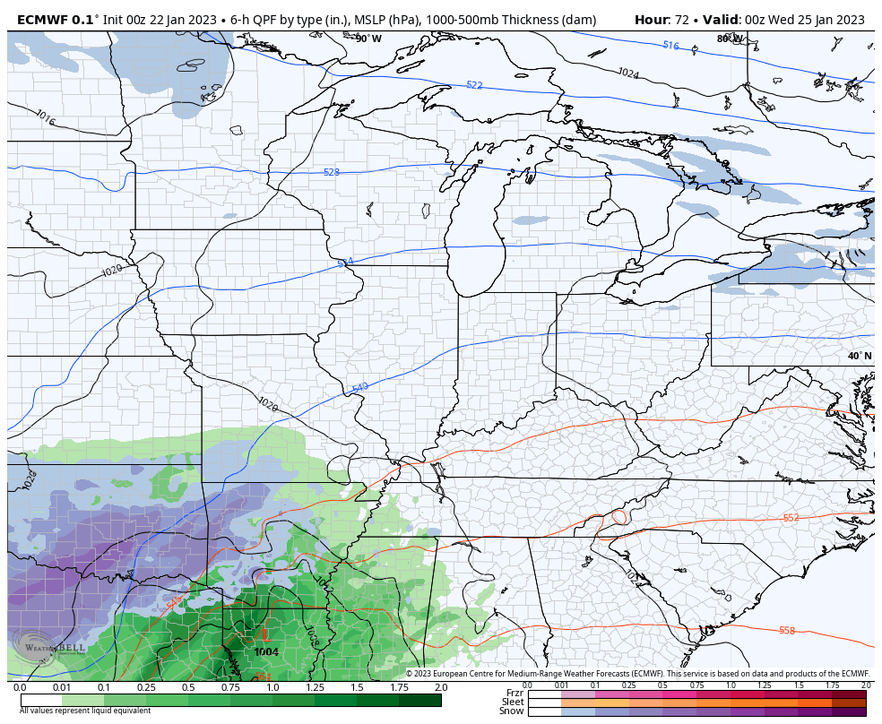
It’s time to watch the trends, but we really haven’t seen much movement on the models over the past few days and we are only a little more than two days out from this system moving in.
I will have your normal updates later today. Make it a good one and take care.

dont need to be hearing the word fence.
Probably see that for all bigger systems this winter, Rolo. At least that’s where I’d place bets.
Thanks Chris, a very sad Winter for Snow Lovers in Kentucky. The Polar Jet and the Subtropical Jet just will not phase to our south and southwest and allow colder Polar air to move into our region ahead of the moisture to give us a major Snowfall.
Maybe when we phase into ENSO / El Nino the above may happen, but that maybe a year or so off ? Noway at this time to predict what ENSO phase we will be in next Fall and Winter.
I checked the high pressure in the Atlantic and it seems to be much larger than usual and has a 30.40 Hg barometric pressure reading. This I believe along with ENSO La Nina has decrease our chances for any accumulating major Snowstorms here and in the Southeast. With the current storms the Ohio River is the ‘ weather fence ‘ and will continue to be so until the ‘ Southeast Ridge ‘ breaks down in a year or so, hopefully. As Chris said in an earlier blog ” hang in there Snow and Winter Lovers. “
What happened to the polar air that was advertised to invade our world again by now. At first they were saying middle of this month and then changed to today’s date. January has been a dull winter month. Everything is happening way north of ky
Typical of model outlooks for this area. Colder air keeps shifting out through time. That is the dilemma of being on a meteorological winter fence. Data is conflicting from an accurate solution. Again if ice stays out, I’d call it a winter win.
Winterlover is right. It still hasn’t turned off cold like it did in Dec. WKY will miss out again. It’s all north. We’re always on the fence instead of a sure bet winter storm. It’s always the fence.
It’s still Jan but I’m calling it now: RIP SNOW
Morning all! Busted forecast this morning, but it’s a pretty bust 🙂
4+ inches with large flakes and little wind in NKY up near CVG and still coming down!
Your out of the Southeast Ridge’s reach temporally. Read my post this morning. It’s as simple as I can explain what’s going on with the Winter weather pattern.
Louisville definitely was on the fence.
I saw plain rain,a mix, and all snow.I would say I received about an inch of very wet snow.
If I did not know the date I would think it was late March.
A steady light snow is falling this morning throughout much of the Chicago Metro Area, and has been occasionally since around 5 AM. We have around an inch here in the SW Suburbs. But because the temp is slightly above freezing, it’s not sticking on pavement at all, just the gra*s*s.