Good Thursday, folks. We continue to see a super-duper weather pattern taking shape across the region as much cooler than normal temps regain control. This is essentially a blast of September temperatures as our pattern turns much more active over the next few weeks.
Let’s get this party started with the weather out there today. Temps are flat out cool this morning with readings in the upper 40s and low 50s with some patchy fog. Highs this afternoon reach the 70-75 degree mark for many across Kentucky. Humidity levels remain fairly low, but I’m watching for a pocket of moisture that can produce an afternoon shower or two. Just in case those go up, here are your radars to follow along…

Friday is another fab weather day with lows back into the upper 40s and low 50s and highs in the 70s.
The good stuff continues into Saturday as temps come up a bit with plenty of sunshine. A little more smoke may return to our skies by this time and, once again, it’s coming at us from the northeast.
Our next system approaches the region late Sunday into Monday with rain and some thunderstorms as we get a reinforcing shot of cooler than normal numbers…

That will followed up by another system by the middle of the week. That brings rounds of showers and storms with it…
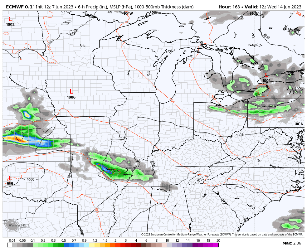
This is the beginning of the much more active setup I’ve been talking about for a bit. Check out the rainfall totals from the operational models through next week…
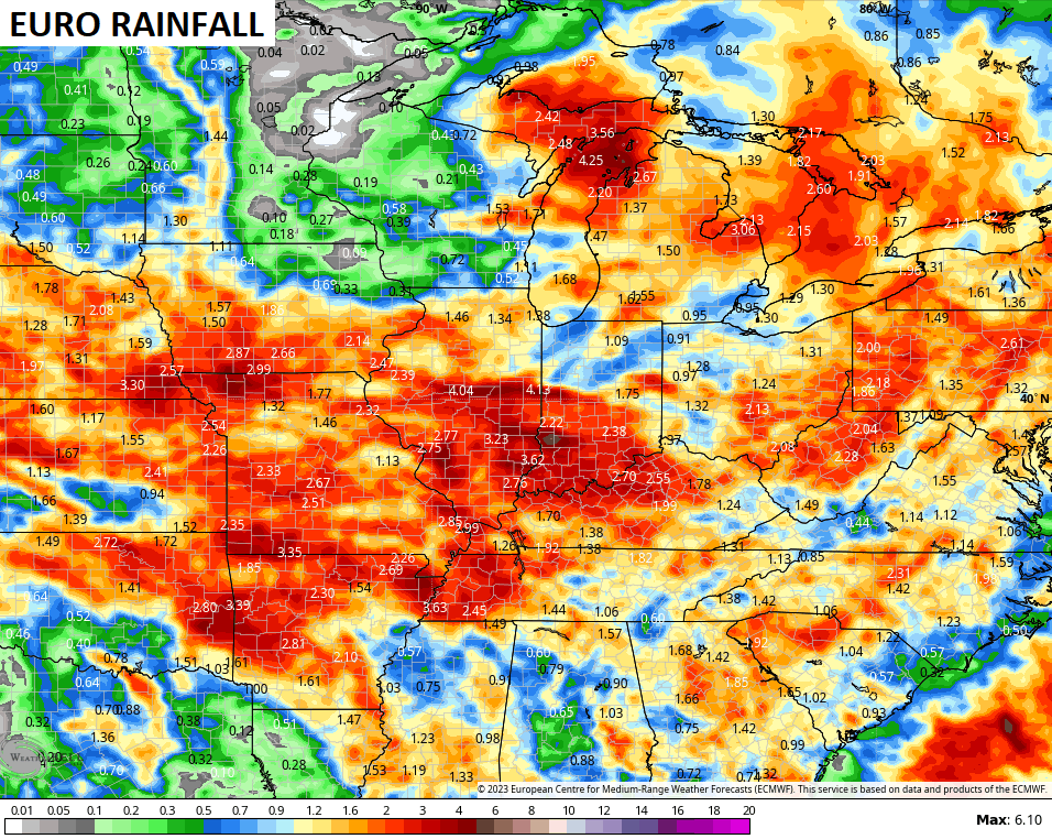

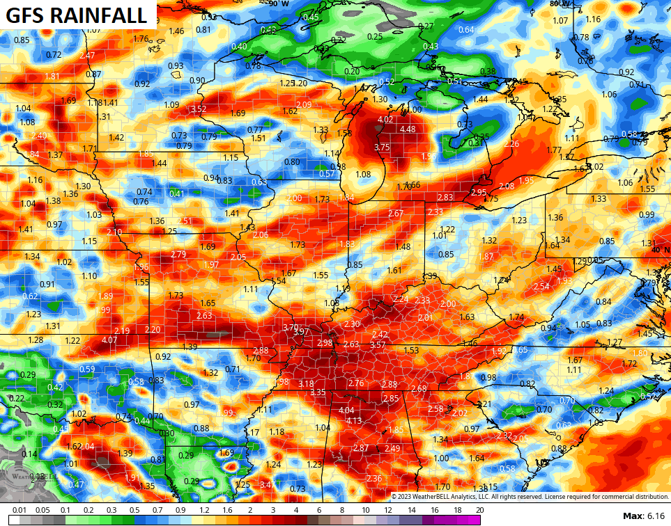
The GFS Extended goes through early July and is putting the above normal rainfall bullseye right on top of our area…
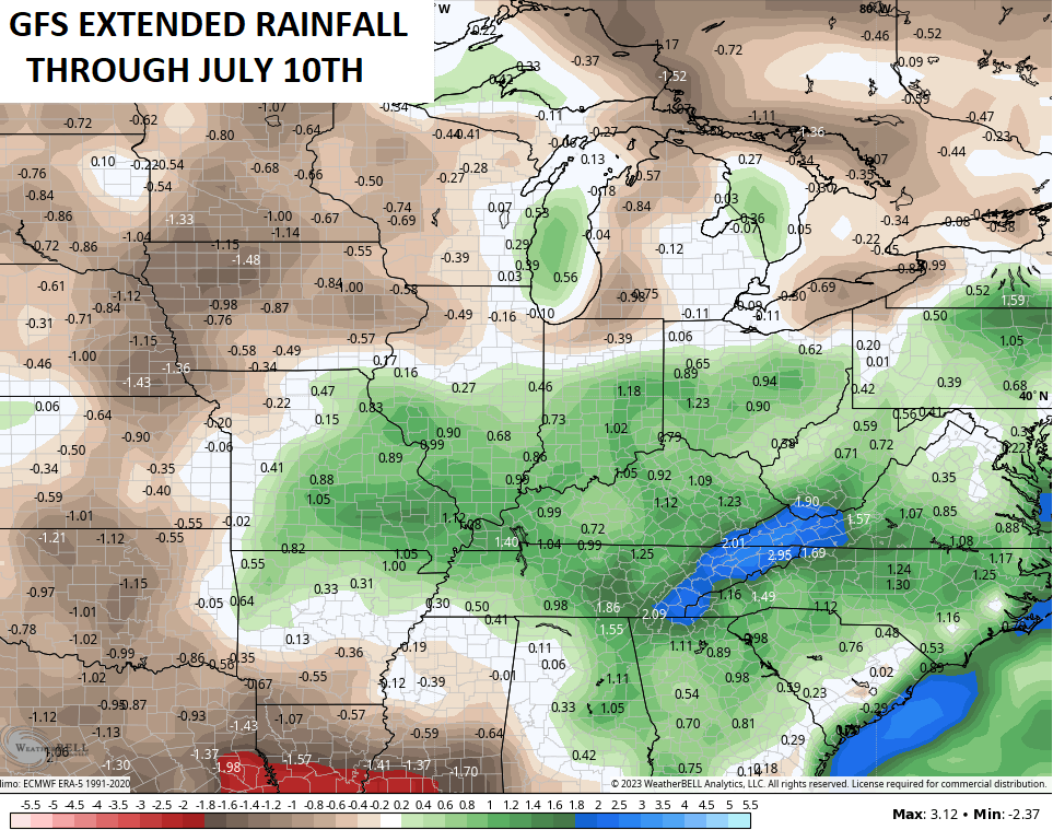
There’s a really good chance for much of the area to finish June with above normal monthly rainfall.
Have a terrific Thursday and take care.

Does anyone know how you can look up the smoke as it moves in the USA like a Doppler radar? I must confess liking these temps we are having.
Crystal, here’s what I found on the smoke. It’s a mystery as to why this smoke has continue to invade the US. Never in my life have I seen this happen. We have been in Omega Blocks before without this problem.
https://www.nytimes.com/interactive/2023/us/smoke-maps-canada-fires.html
Some parts of western Canada have been suffering from a semi drought.
Many forests are burning.
The jet stream brings the smoke south into the USA.
The jet stream isn’t flowing at its normal linear west to east pattern for this time of the year.
Thanks
Schroeder, for much of May we’ve had a retrograde flow in place at the surface and mid-levels of the atmosphere. These NE to SW and E to W winds have pushed smoke from fires in Quebec, Labrador and Nova Scotia into the continental US. It is very unusual (not normal?) pattern, but these are very unusual times!
Thanks Joe. ENSO is a very intensive study, and I’m still learning. I don’t know how this El Nino will affect us here in Kentucky, but some areas in the Southern States will have a better chance for record Snows. The amplified Subtropical Jet and Polar Jet must phase over the Southern Rockies to produce major Snows here in the Ohio Valley and the threat of more Nor’ Easters than normal. Therefore, most precipitation will be in the form of Snow thus a drier Fall and Winter. El Nino Summers are usually hot and dry, but not always.
The current Omega Block should be over by this time next week, and also this awful smoke intrusion will clear our skies. Thanks for sharing a very informative article on ENSO phases.
I’ll believe it when I see it regarding the forecast of rain.
Thanks Chris. We received about a half inch of rain from yesterday’s event. We will take every drop that falls. Hoping the rainfall totals on the various models are correct. Very comfortable temperatures for June.
We only picked up another 0.01″ of rain at my location just south of Bowling Green, bringing the total for the past 19 days to 0.02″. This is bad…
I came across an article discussing the anticipated intensity of El Niño, and its probable effects. More realistic Winter weather and a lessened threat from Atlantic hurricanes are pluses for us; the rest, not so much:
https://www.severe-weather.eu/long-range-2/el-nino-strong-development-noaa-watch-forecast-seasonal-weather-winter-impact-united-states-canada-europe-fa/?utm_medium=social&utm_source=grow.me&utm_campaign=grow_share_widget&fbclid=IwAR2izaTsTANG_-nkWkaU8ByoCm21OHy9Imgh3J6ca2bxT1dgDkk3Z9MawTM
Here’s the latest on ENSO :
https://www.climate.gov/news-features/blogs/enso
In the last 20 days, no measurable rain has fallen at my location in the SW Suburbs of Chicago. An area-wide rain is expected by Sunday, but how much is in question.