Good Friday and welcome to September! It’s the start of Meteorological Fall and our weather continues to look fine. This fine weather continues into Labor Day Weekend, but I am putting that small shower chance into the mix for parts of the region.
Before we look ahead, let’s look back at our tame temperature summer. The June through August period was slightly cooler than normal across Kentucky and much of the region…

The same 90 day period actually shows much of the country normal to a touch below normal. Areas of the deep south and toward the southwest were hotter than hot for the bulk of the summer…

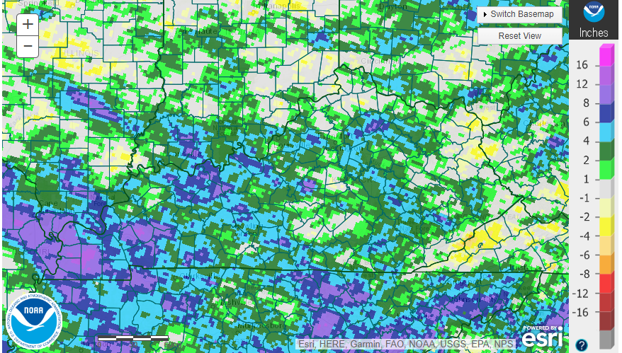
This tame temperature summer also came with much above normal rainfall for much of the state. Areas of western Kentucky finished more than a foot above normal for the summer…
The constant heat and drought mongering from some local weather sources proved to be unwarranted once again.
The weather on this first day of Meteorological Fall is awesome with readings this morning in the upper 40s to middle 50s. A mix of sun and clouds will be noted this afternoon with just a slight chance for a stray shower across the south central part of the state.
This is coming in from the south and you can follow along on our radars…

The increase in some clouds and that slight shower chance continues into the first half of the weekend. The Hi Res NAM is most enthusiastic about isolated showers and storms through Saturday night…

Temps from Sunday through Tuesday will generally run into the mid and upper 80s with the occasional 90 in some of the traditional hot spots.
The pattern changes for the middle and end of next week as a cold front drops in from the northwest. This is being pushed by a system that may try to cut off from the main flow…

The end result would be rounds of showers and storms to impact the region IF that scenario plays out…

That would also bring some pretty cool temps back into the region through next weekend.
Is there still a chance for Idalia to circle back toward the east coast? It’s a small chance.
Here’s the latest track from the National Hurricane Center…
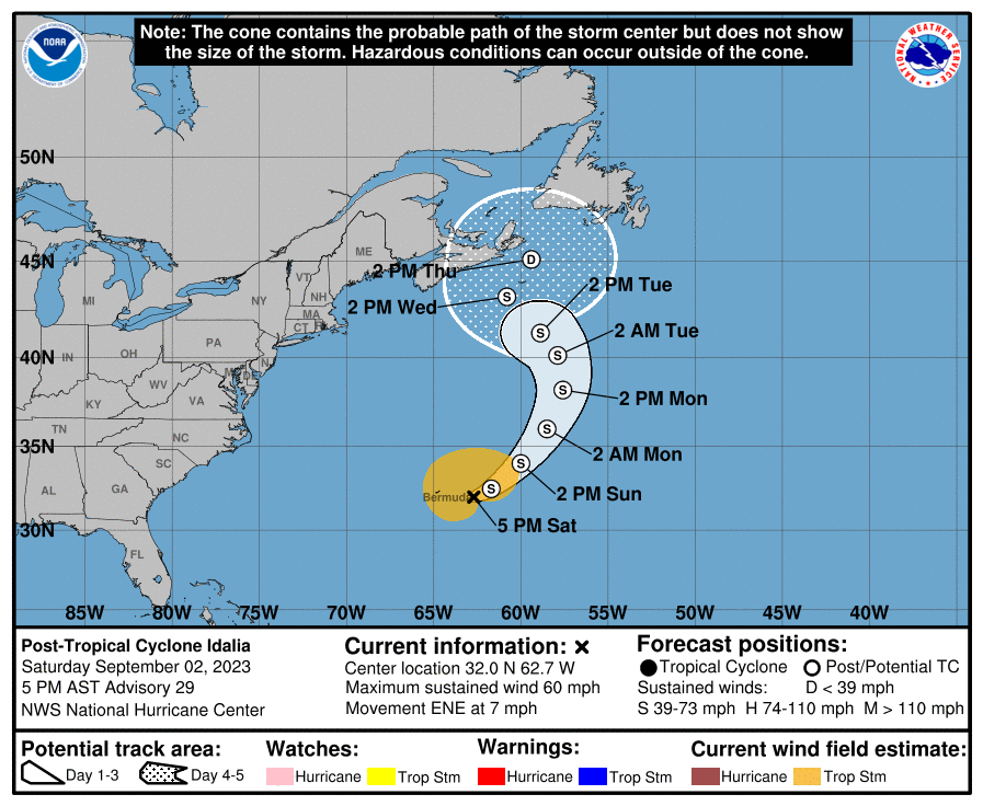

That probably won’t have a direct impact on the east coast, but it may play a role in slowing down the pattern behind it across the US.
Have a fantastic Friday and take care.

Thanks Chris. Yesterdays weather felt like Fall. I wish it could last the entire month with timely Fall rains, but NOAA came out with their long ranged probability forecast yesterday. May be trending warmer and drier as we get deeper into the month. What do you say about the next three months ?
NOAA’s probability outlook for September 2023. Release August 31, 2023 :
https://www.cpc.ncep.noaa.gov/products/predictions/long_range/lead14/index.php
Equal chances means : NOAA’s words ” we don’t know “
I don’t think it was tame much at all.
Agree. For instance, the official weather stations measure rainfall and say we were great. But several times it pour a bucket of water on hard ground which ran downhill to the Ohio River before we could even celebrate the rain. The low creek levels most of the summer are a testimony to dryness (but you have to get out of the office to notice that). Secondly, the wind damage has been eye-opening. That doesn’t show up on those charts.
As long as the Tropics are occupied with Hurricanes and spin ups, good soaking rains will be scarce in our area. El Nino seems to be missing in action as the PDO is still very negative, and the AMO is positive. These teleconnections seem to tell the Earth’s climate in the decades to come. I think they are more or less semi permanent. May be the same phase for 40 years or longer. Don’t know.
I’ve seen cooler Summers, especially in 1964 and and 1992 due to volcanic activity. In the Fall of 1992 we had our first 4 ” of Snow on October 30th.
Omit one of the ands.
Here we go again with the short-term drought across the Chicago Metro Area. Not a drop of rain has fallen on the area for the last 14 days, with no rain in the forecast until next Wednesday at the earliest. In June, we went 21 days in a row without any measurable rain, but all the rain we received in July more than made up for that.
It’s also going to get hot here, with temperatures in the 90s Sunday through Tuesday.
Everyone have a great Labor Day Weekend! Get out and enjoy the sun and warm temps if you can.
I hate when it gets 90 + degrees with no rain in the Fall season. When the Pacific ( PDO ) goes positive and the Atlantic ( AMO ) goes negative we will have major changes in our climate. Instead of Global Warming, we will have Global cooling. This occurred in 1976 and lasted till 1979 and then reversed again. Last time the PDO was positive was in 2014 – 15. And I remember the 15 inch Snowfall and temperatures below zero in February that year.