Good Friday, folks. We have a potent setup rolling in for the weekend as a big storm system blows into the Bluegrass state. This will bring the potential for strong storms, heavy rain, gusty winds, a big temp crash and some snowflakes. All of that may happen within a 24-hour window. I’ve got a blowout post, so buckle up.
Today is pretty darn nice with temps in the upper 50s and low 60s with gusty southwest winds and a few clouds rolling in. Those clouds are ahead of the weekend storm system that deserves a full breakdown:
SATURDAY
- Temps surge into the 60s on a stout southwest flow as one low pressure works toward the Great Lakes.
- Scattered showers and a few storms develop during the morning and early afternoon.
- Storms increase Saturday afternoon and evening.
- Some of these storms may be strong or even severe, especially in the west and south. This is where the Storm Prediction Center has a low-end risk for severe weather..

SATURDAY NIGHT
- Our cold front slows down right on top of us as a stronger low pressure develops along it. This rolls right across central and eastern Kentucky into Sunday morning.
- Heavy rain and thunderstorms are likely during this time.
- Locally heavy rains may cause some quick rises on creeks and streams.
- Winds crank with 30mph or greater gusts possible.
- Colder air crashes into western Kentucky and there’s the chance for a few flakes to fly along and west of Interstate 65.
SUNDAY
- The low pressure pushes off to the east and northeast with cold air crashing in from west to east.
- Heavy rain in central and eastern Kentucky is likely in the morning hours.
- As the cold crashes into the back edge of this rain shield, we watch to see if a band of light snow can develop. Odds are against this at the moment.
- The best chance for this is across the eastern half of the state during the afternoon.
- Temps by afternoon drop into the 30s statewide with a wind chill in the upper 20s.
SUNDAY NIGHT
- Northwest winds will likely touch off some flurries or a light snow shower across the east, especially.
- Overnight lows drop into the 20s.
- Below freezing temps and a lot of water from earlier rains may combine to cause some icy spots to develop.
MONDAY
- Morning flakes are possible in the east.
- Temps are mainly in the 30s for highs with wind chills making it feel several degrees colder.
Let’s take a look at the models, starting with the Hi Res NAM. This model only goes through 7am Sunday, but the future radar is showing a transition to some snow at the end of the run…
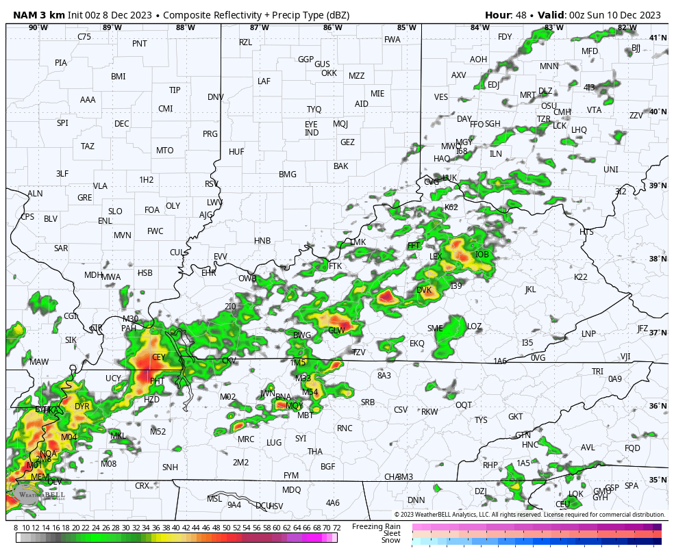
That appears to be going toward earlier runs of the NAM, but the latest run of the model isn’t as gung-ho on the snow but still produces some of the light stuff..
If you’re a snow lover, the NAM fam is your best bet right now. Other models do bring some flakes into the eastern half of the state, but not quite like the NAM and Hi Res NAM, and those aren’t showing a lot.
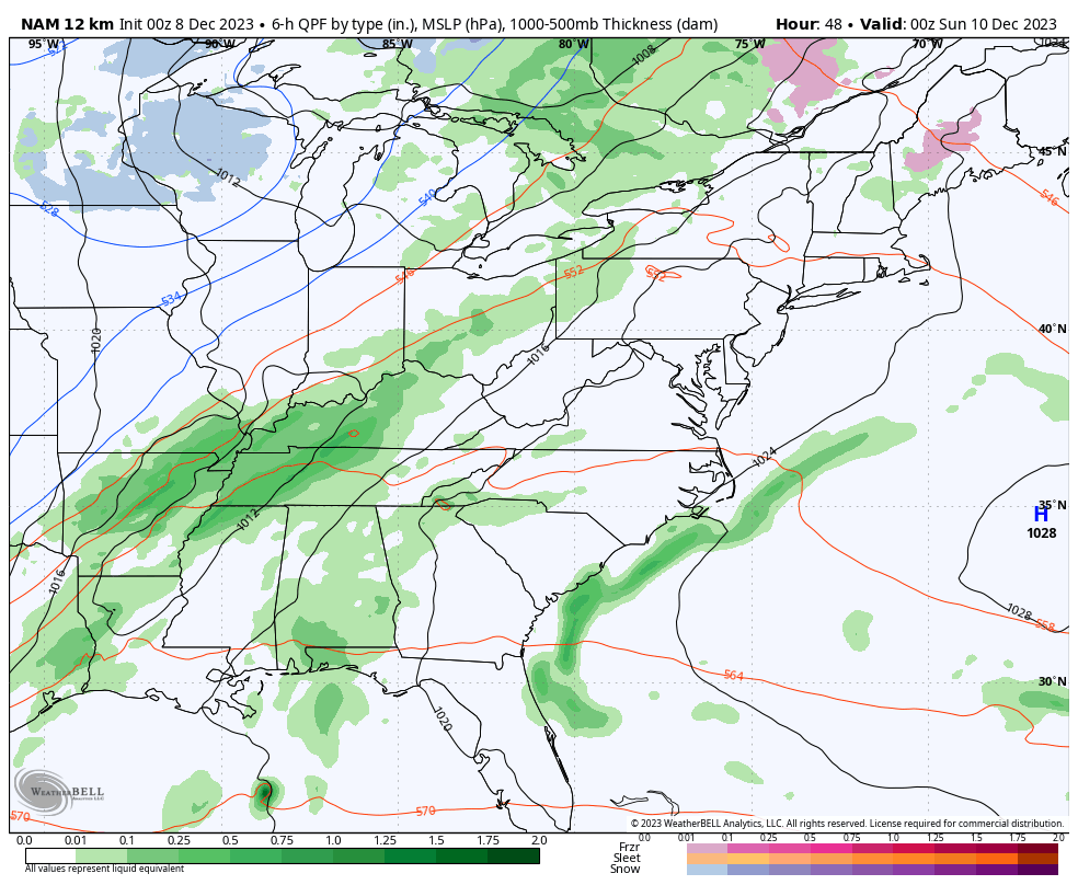
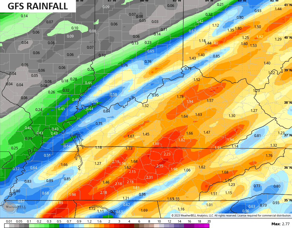
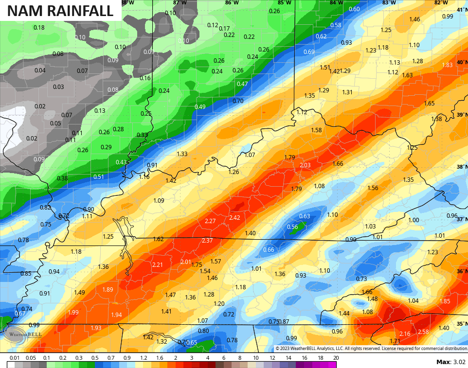
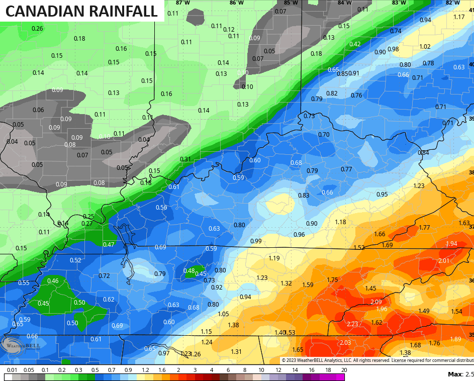
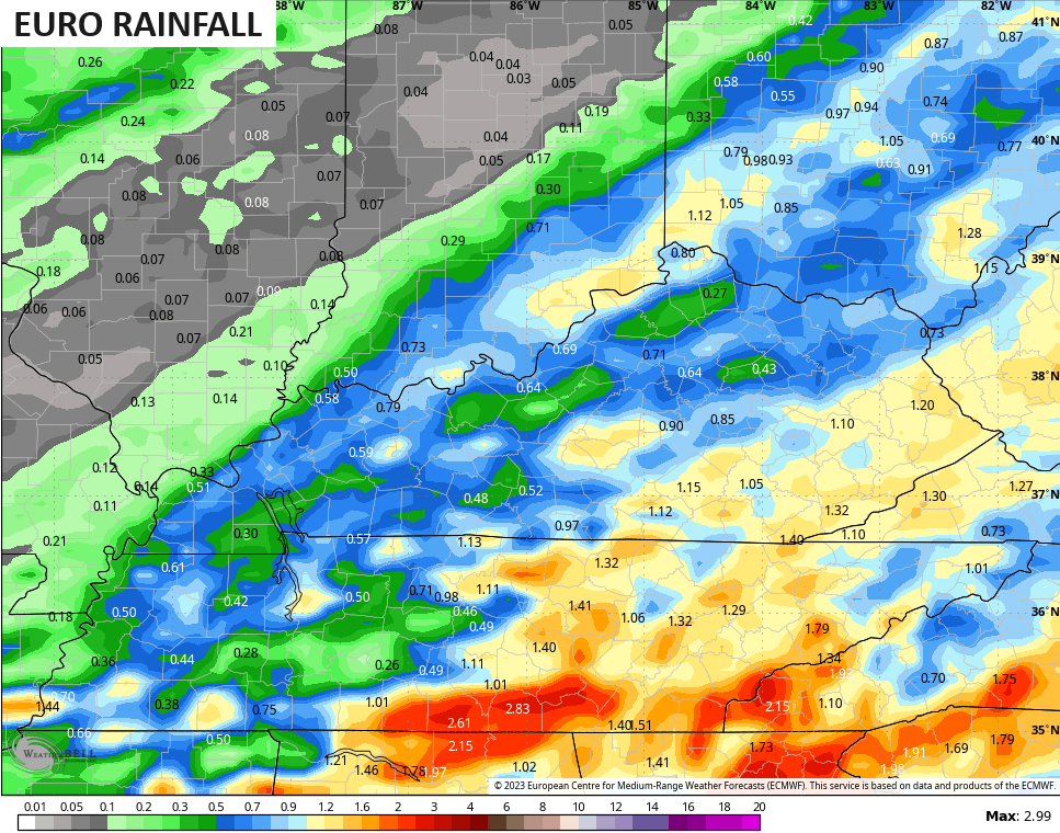
Rainfall from this system continues to be heaviest on the American Models like the GFS and NAM…
The Canadian and EURO models aren’t as jacked up with the rain numbers…
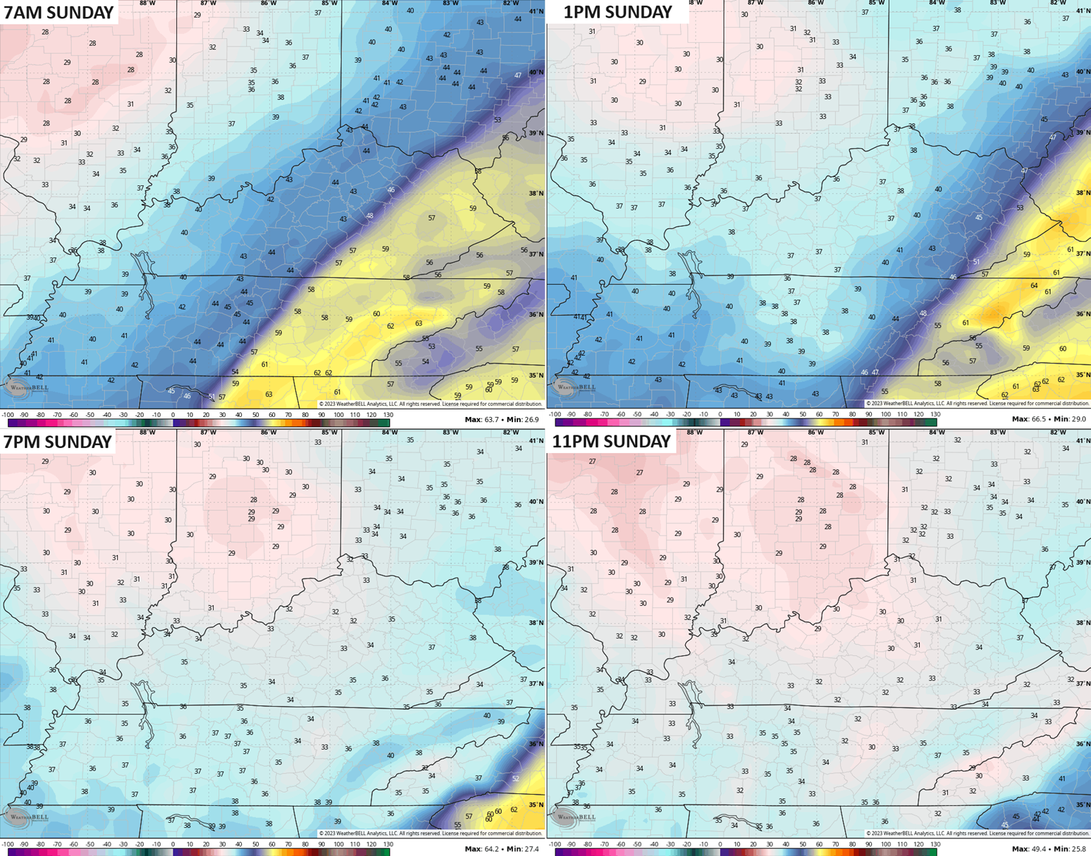
Let’s talk about the temp behind the Saturday night and early Sunday cold front. As you know, highs ahead of the front on Saturday are likely to reach the 60s. Those numbers come way down once the front passes. Check out the progression…
The weather after this turns pretty calm next week before ramping up next weekend into the week leading up to Christmas Weekend. This is the time of December I’ve been pointing to for winter to settle into our region. This change is also being backed up by the MJO swinging into colder phases and the longer range models having a consistent signal for cold and winter weather.
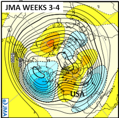
It’s a transition that sees lower heights developing across the south and southeast before expanding across much of the eastern half of the country as blocking starts to do some work up in Canada. You can see this by looking at the JMA. Watch the trough develop in the south in week two…
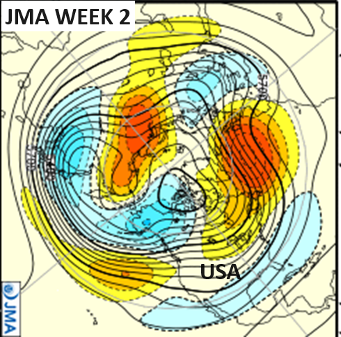
Now watch what happens Christmas week into the last week of the year…
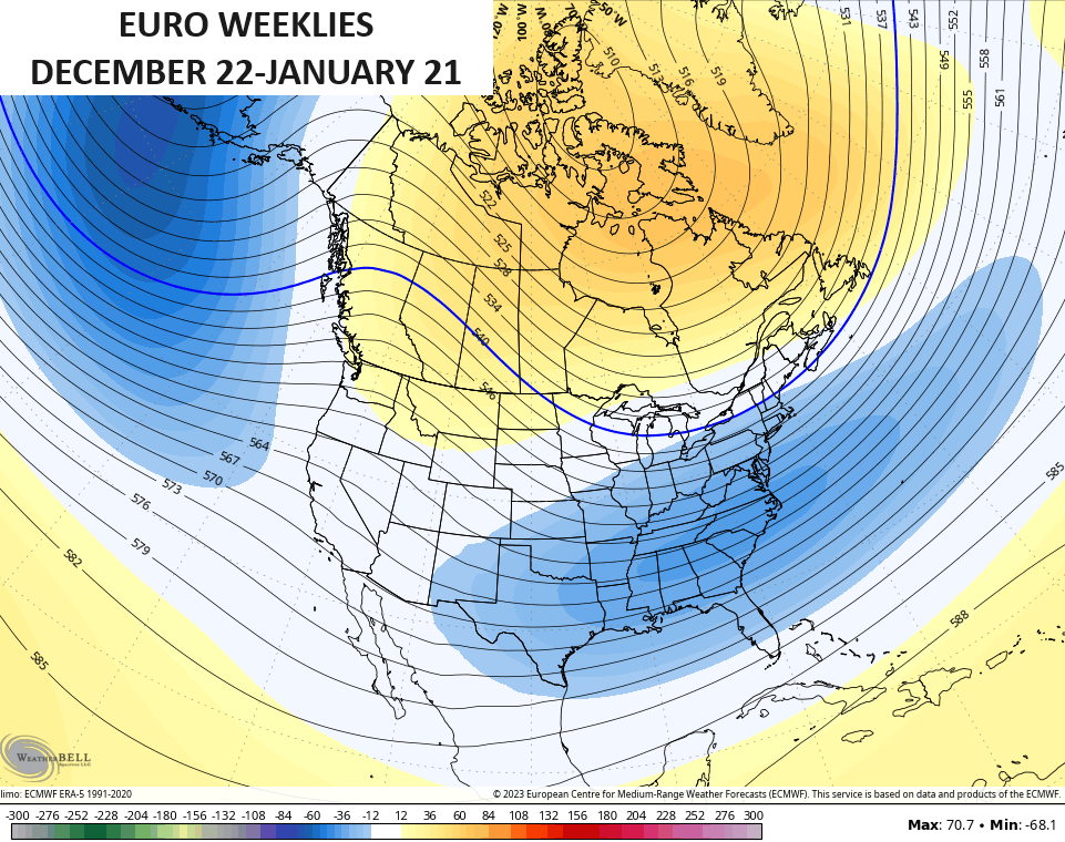
This looks a lot like what the EURO Weeklies have been showing for the end of the month and into January…
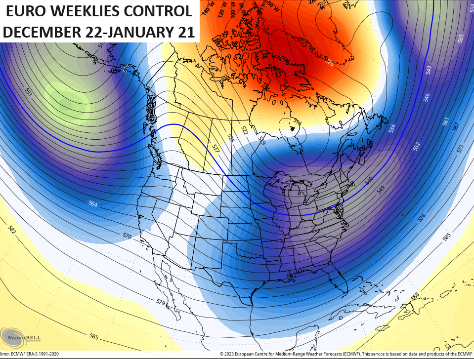
The control run of the EURO Weeklies continues to show an even deeper trough…
🥶❄️
I will have updates later today, so check back. I leave you guys with your Kentucky radars…

Have a fantastic Friday and take care.

Thanks Chris. Any prediction for severe weather makes me nervous. I wish that warm front would stay well to our south and we would receive more widespread Rains, and the chance of a secondary low forming on the cold front bringing a Rain to heavy Snow scenario for the entire State. It’s been several years since I’ve seen this happen.
Enjoy the weather today if you can endure the windy conditions from the dry southwest. Until we receive at least two inches of Rain, I’m very concerned of Wildfires and Forest Fires in my area.
Have a Great and Safe day.
Here is the link on the Blizzard of 1917, which occurred on the eight of December. A La Nina year that had a positive charged Pacific Decadal Oscillation, which caused the long, Cold and Snowy Winter. Very Rare.
https://www.weather.gov/lmk/december_1917_january_1918
good to see chris still onboard with the cold late December.