Good Saturday, folks. Our light snow maker did its thing and is gone and now we deal with a quick-hitting blast of cold for the weekend. This up and down pattern looks to repeat itself next week with a mild up before another blast of winter.
Let’s start with what’s going on out there today. Morning snow showers and flurries fade away across central and eastern Kentucky, but a few slick spots remain. Temps today range from the upper 20s to low 30s for highs with a gusty wind making it feel even colder.
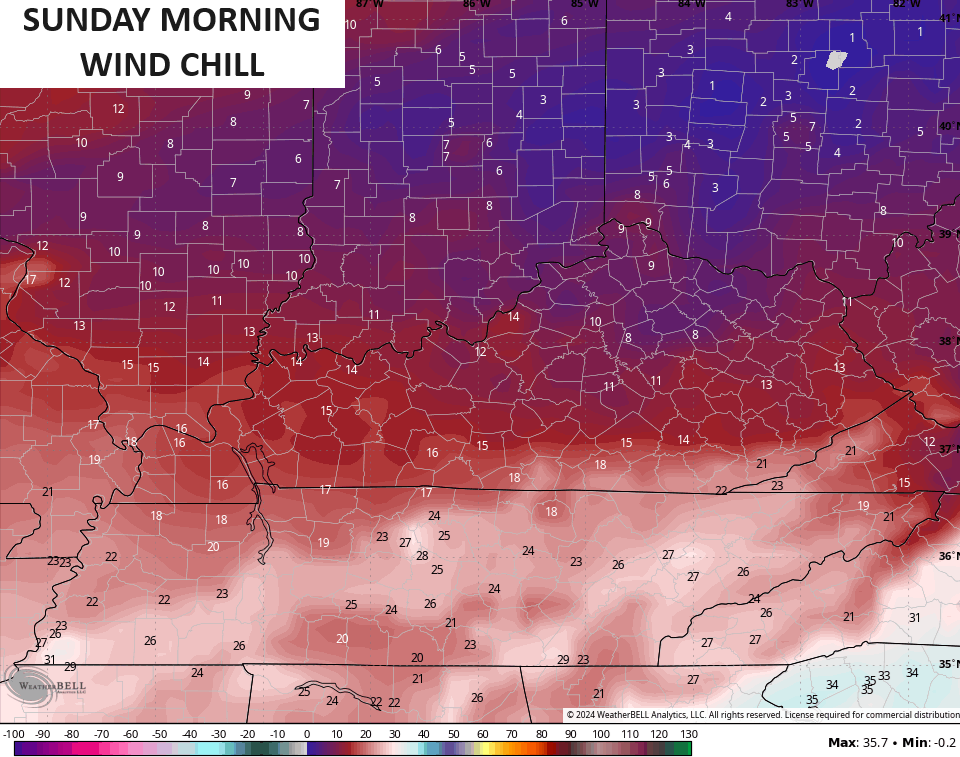
Those wind chills tonight and Sunday morning may drop as low as the high single digits at times…
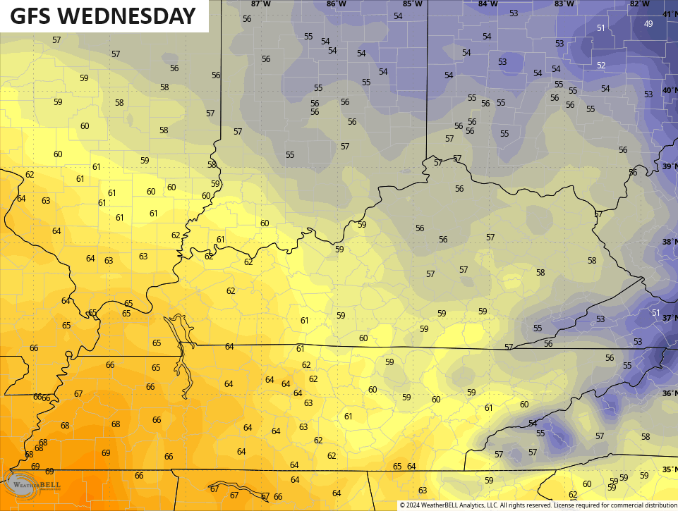
The rest of Sunday looks partly sunny with temps reaching the 40s for most. This starts a milding trend that takes us through the middle of the week when a strong southwest wind boosts temps toward the 60s for some areas…
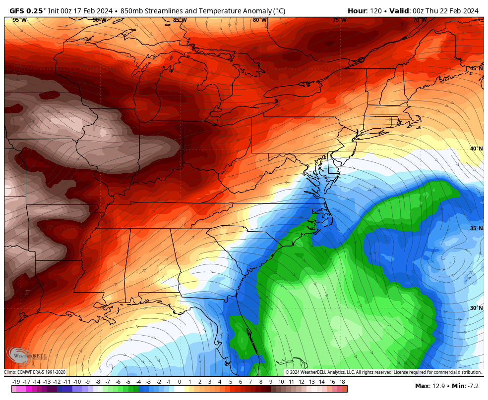
That milder air will get wiped out as a storm system moves through Thursday and Friday. That one brings rain and the chance for some snow along for the ride. Watch how fast we go from above normal to below normal once again…
This is one amazing back and forth pattern and it’s one that can get us into some trouble as we head into March. This much warm air meeting up with frequent cold blasts can fire up some big storm systems and we know March can bring some very wild weather. This particular pattern ups the ante on everything from severe storms and flooding to a healthy snow event.

Got a nice coating on gra ssy areas in Richmond and roads seem good other than maybe ice.
I basically had a steroid festive flakes event.
I received a whopping 1/4” of snow.
There was some decent banding just north & south of the city.
I might be around a total of 3” for the winter.
It looks like the roller coaster weather pattern will continue into the upcoming week.
Thanks Chris. Yesterday evening we had periods of heavy rain with a thunderstorm to add to the excitement. By 9:00 the rain that was left over, turned to snow and quickly ended. Just a coating of snow. Typical weather here for February. Total precipitation was .36 ” according to the Kentucky Mesonet.
I read the NWS service discussion this morning and it sounds like the rest of February will be mild, but the beginning of March winter weather may return. Really ready for this winter to be over !
Enjoy your Saturday ! Suppose to be Sunny. At least that something to look forward to.
.34” of rain at our house. Pretty layer of snow. Coming out of the high school gym after a basketball game last night, it was magical. Heavy snowfall. Snow-covered vehicles & roads. Slow traffic – but moving well. Daffodil shoots on the southern exposure are up 4-5”.
All the years in the nursery business, 40 years to be exact. Everytime Easter is in March we have a hard freeze around that time. Spring weather didn’t arrive until after the 15th of April. I went by this for a number of years with my selling and plantings.
By the way, we didn’t receive even a coating of snow, but it is cold and very depressing. One weather forecast I got right. LOL….
It was a very cold 12 degrees early this morning here in the SW Suburbs, with a NW breeze making the wind chill -3. That’s pretty impressive considering there’s no snow on the ground and it’s late in the season.
The temperatures Friday averaged below normal in the Chicago area, breaking an amazing streak of 25 days in a row of much above normal temps. Though, only a trace of snow fell at O’Hare Airport, and a tenth of an inch at the NWS Forecast Office in the SW Suburbs. It was our first measurable snow in four weeks.
Mike, I heard from my Sister, who lives in northern Indiana and pictures of an 8 inch snowfall that fell yesterday. In my home town in south central Indiana they received only 4 inches. Here in Maple we received none, just cold / dry air, but the Sun made an afternoon appearance.
Yesterday I was so confused with this storm… First, I though it would be more widespread precip shield.. but it was more streaky… and I noticed they issued a WSW for parts of Indiana and Ohio…but I was watching the radar and the precip shield was moving out fast for everybody…and I’m thinking, “how are the expecting WSW criteria snows looking at the radar with the end of the precip shield fully in sight?” It did snow hard but it was extremely short duration.. I suppose the we did at least (here) receive around the forecasted amount from the models 1-3..