Good Friday, everyone. Another round or two of strong to severe storms will likely impact Kentucky on this day after the big day. Today’s storms are ahead of a cold front that promises much better weather for our weekend. The longer range finds the potential for Beryl to impact our weather.
Let’s start with today and roll ahead.
Tropical humidity is out there ahead of our front and that means these rounds of thunderstorms will continue to be loaded with lightning and torrential rains. The torrential rainfall will be one that can cause more flash flooding issues on a local scale, so keep that in mind.
The storms may also produce damaging winds as they sweep across the state, especially this morning into the early afternoon. The Storm Prediction Center continues to highlight parts of the state in the Severe Weather Outlook…

There’s just enough shear available for another quick tornado spin up like what happened in Louisville on the 4th of July.
Saturday and Sunday look absolutely awesome behind the front! Humidity levels tank with temps in the 80s will team with a mostly sunny sky to give us a taste of the good stuff. Soak it up!
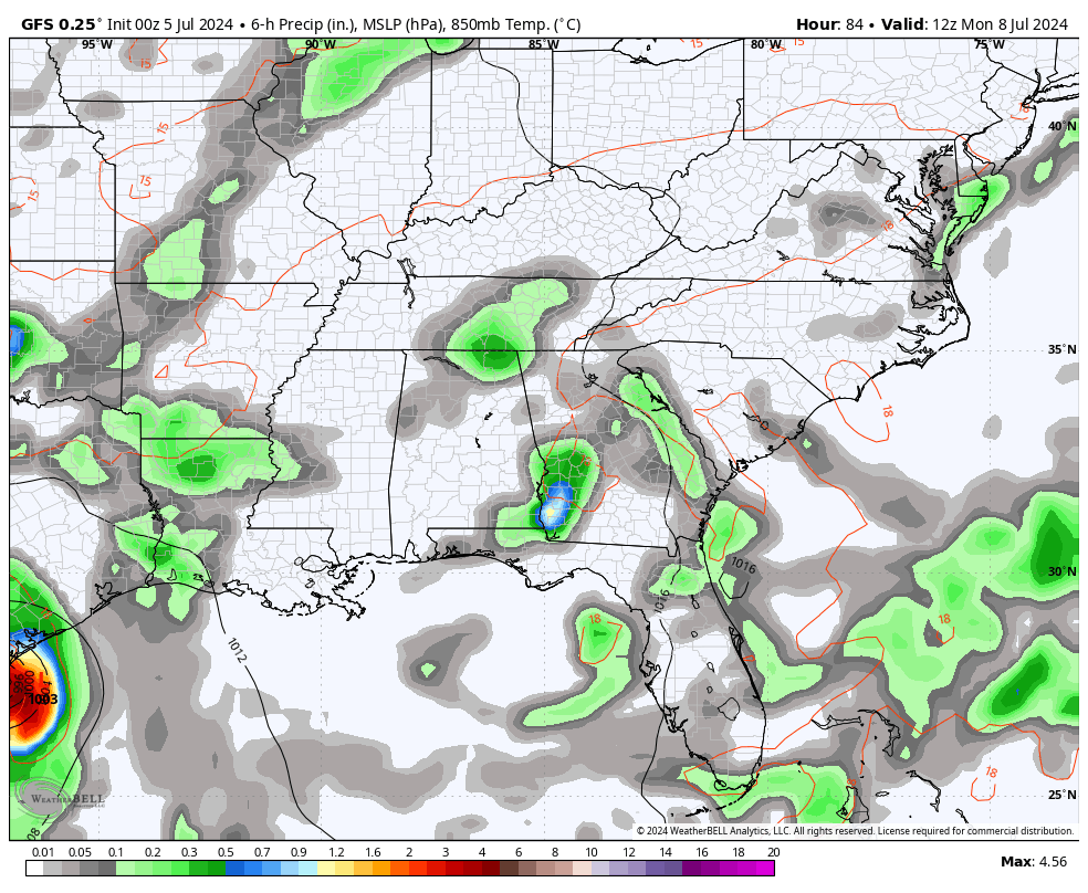
Steamy air returns for Monday as we get set for more rounds of showers and storms from late in the day through much of the week. We may even get some tropical moisture in here from what’s left of Beryl. That shows up on the GFS…
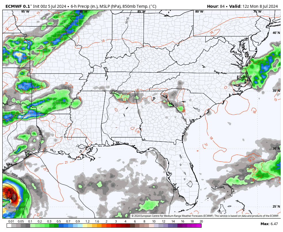
The new EURO is even more of an impact from Beryl…
Temps come down to normal to below normal for a spell before heat tries to take a big jump at us the week after next.
The overall temp forecast from the EURO Weeklies shows our region with normal to slightly above normal temps through the middle of August. You can clearly see the heat across the west and northern tier of states during this time…
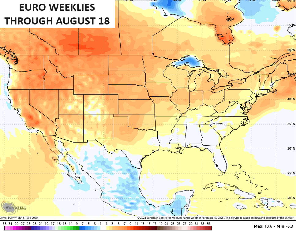
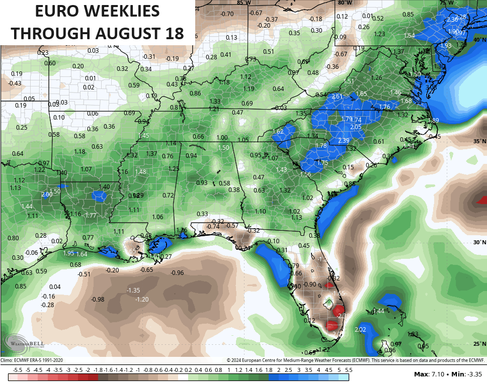
Notice how our region into the deep south is much cooler than the rest of the country? That’s because the same period if forecast to have above average rainfall…
Hurricane Beryl slams into the Yucatan today before emerging into the Gulf of Mexico as a Tropical Storm on Saturday. This will likely become a hurricane again before nearing Texas for a possible late Sunday or early Monday landfall. Here’s the latest from the National Hurricane Center…

The satellite shot shows our powerful storm very well…

Can some of that tropical moisture eventually wind up here in Kentucky or surrounding areas? That’s a possibility later next week. The various ensembles continue to show the chance for the remnants to lift our way…
GFS ENSEMBLES

GLOBAL ENSEMBLES

EURO ENSEMBLES

It may wind up just being some offshoot tropical moisture that we get in here, but it’s something to watch as we forge ahead.
Here are your storm trackers for the day after the 4th of July…


Current watches

Possible Watch Areas

Have a great Friday and take care.

Thanks Chris. Yesterday’s ‘ Fourth of July ‘ weather was very oppressive ( high temperature of 93 degrees, ) except we had a warm breeze from time to time. Still very uncomfortable. We had a brief shower in the late afternoon. My area of northern Taylor county is still in the ‘ pocket drought. ‘ No measurable rainfall since the the Summer started. I have my doubts that the remnants of Beryl will bring enough moisture to my area of the state. We shall see in the coming days.
Now that the ‘ Fourth of July ‘ is in the past, I focus on the coming Fall and Winter. With a strong negative Pacific Decadal Oscillation in place indicating a forming La Nina for Fall and Winter 2024 – 25. UGH !!! As being a Winter lover of Snow, I would prefer an El Nino operating in a positive ( PDO. ) Maybe that will happen in the Fall and Winter 2025 – 26 ? Hoping I will still be around to enjoy the Snow ?
Make it a great day everone !
Heat and summer win out.
Since June 27th our yard has had 0.05” of rain. Doppler shows time and again the rain sweeping across the region and dissipating as it got to us, or spawn huge cells just to our east and lumber toward West Virginia. We have stood outside and watched and listened as the shield deflected moisture around us. We’re ready for some moisture from the heavens!
We’re all ready. Even me.
A strong thunderstorm moving through the Bowling Green area right now has dropped 1.10 inches of rain, so far. Rainfall rates at times have peaked at over 2 inches per hour, nad I recorded a peak wind gust of 30 mph. Warren Rural Electric is currently reporting 422 customers have lost power.
Since Sunday we’ve picked up nearly 2.75 inches of extremely welcome rain, and there’s more to come.
Looks like I maybe in for some severe storms later just got a severe thunderstorm watch. If it doesn’t go around me we can use the rain. Did anyone see where Palm Springs was at 122 yesterday said they might set a record high even for them with a possible 130 in the coming days Wow!!
Jeff you would like it in Palm Springs LOL J/K Jeff 122 and possibly 130.
Not really. I have limits. 😉