Good Monday, everyone. We are kicking off a very active week with rounds of showers and storms to close out July and begin August. These storms will bring a lot of rain to the region, giving us a flash flood threat and some of these storms may also be severe.
We are watching the northwestern sky today for clusters of strong to severe storms developing and rolling across, especially, central and eastern Kentucky. The best chance for these storms is this afternoon through overnight hours.
Some of these storms may be strong or severe and the Storm Prediction Center is highlighting this potential with today’s Severe Weather Outlook…

These storms may be able to tap just enough shear to spin up a tornado or two. This is also highlighted by the SPC…

Damaging wind is the main threat from these clusters of storms…

A few of the storms may also have quarter-sized hail or larger…

The threat for strong to severe storms will be with us again on Tuesday as additional action drops in from the northwest. Here’s the Tuesday Severe Weather Outlook from the Storm Prediction Center…

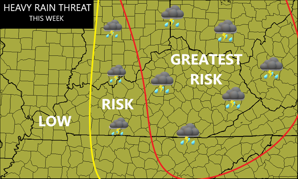
This same pattern looks to hang tough through the rest of the week as we are locked into a setup that features big complexes of storms developing to our northwest then dropping into Kentucky.
Here’s my latest thinking on where the heaviest rains fall this week…
We have to be on guard for flash flooding from any storm that goes up. My worry is we get into a short-term setup where storms train over the same areas one right after the other. If that happens… Ugh.
I will try to drop by for another update later today and will the latest on WKYT-TV starting at 4pm. As always, I have you guys loaded with your Monday storm tracking tools…


Current watches

Possible Watch Areas

Make it a magnificent Monday and take care.

Let it rain this week then it can be done for a bit.
Thanks Chris. We had about a half inch of a very weak rain shower yesterday afternoon. Every little rain shower helps, but I’m still waiting for that good soaking rain. Has anyone notice that we don’t have the typical afternoon and evening thundershowers like we use to several years ago ? The Earth’s climate is changing, no doubt from me anymore. The only thing we will notice is the days are getting shorter, but the weather pattern remains. In the future our most pleasant season may be our Winter months.
Enjoy the day everyone !
Probably the biggest change that I see Schroder is in the weather during the seasons of Spring and Fall. The transition from cold to hot and hot to cold is no longer gradual, with the result that Summer has effectively expanded by several weeks at either end.
The other major change is that instead of being restricted to specific seasons, severe weather can and will occur at any time during the year.
Your exactly right Joe. Summers are longer and Fall weather has replaced our Winter weather. One can’t go out on a Summer’s evening and enjoy the stars and planets that God created for us, because the atmosphere is full of smoke and pollution. Man over time has destroyed what we use to have in weather and other issues here on Earth.
Storm cluster threats I have been talking about for this week have already ramped up across Iowa and Illinois this morning.
This cluster is diving southeast quickly in Illinois and will drop 2″+ of rain in southeast Kentucky
As the storms get south of the Ohio River they been weakening with this weather pattern. A good thing, because of the stronger than normal Bermuda High. A bad thing if one needs rain.
Kind of notice he didn’t mention how hot it’s gonna be this week. My local weather man has 90-95 through out the week into next week as well. Of course providing that the pop up thunderstorms doesn’t cool it down
The cloudy, smoky skies ( pollution ) has held our temperatures down due to high pressure forcing air aloft to descend.