Good Wednesday to one and all. It’s the middle of the week and all eyes are on a hurricane down in the Gulf of Mexico. Francine comes ashore later today and will roll up the Mississippi River and impact our weather later Thursday and Friday.
Hurricane Francine is nearing the Louisiana coast and will make landfall by the evening. This system is interacting with a stalled boundary across the Gulf coast to produce a massive swath of clouds that will roll into our region as the day wears on.
Here’s the satellite shot showing all this…

This will have a healthy impact on the New Orleans area as the National Hurricane Center has continued to slowly push the track farther east. This system will then lift northward through Mississippi tonight and Thursday before edging back to the northwest a bit into western Tennessee and western Kentucky.
Here’s the latest information and track forecast from the National Hurricane Center…

Take out interactive radar out for a spin and watch Francine slam into Louisiana today…
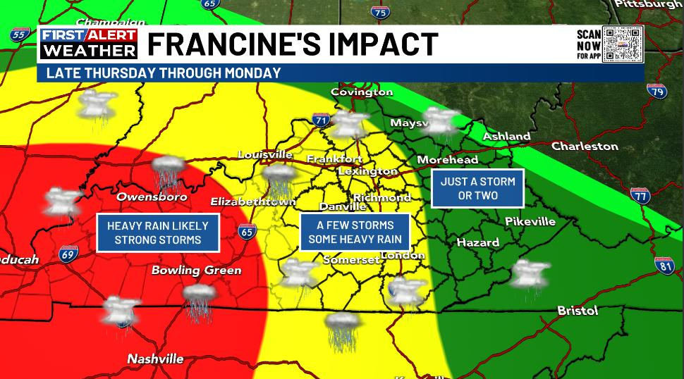
As we get closer to Francine impacting Kentucky’s weather, we are able to fine tune things a little better. The first spiraling bands of showers and storms arrives late Thursday and Thursday evening across western and southern Kentucky. This action increase as it spins counterclockwise around the remnant low moving into western Tennessee and western Kentucky into Friday.
The greatest threat for heavy rains and some strong storms will be across the west. A few spiraling bands of strong storms and heavy rains will show up into central and parts of eastern Kentucky with a sharp cutoff on the northeastern side of all of this.
Here’s a look at what I’m thinking at the moment…
This will get updated as the exact inland track becomes more apparent.
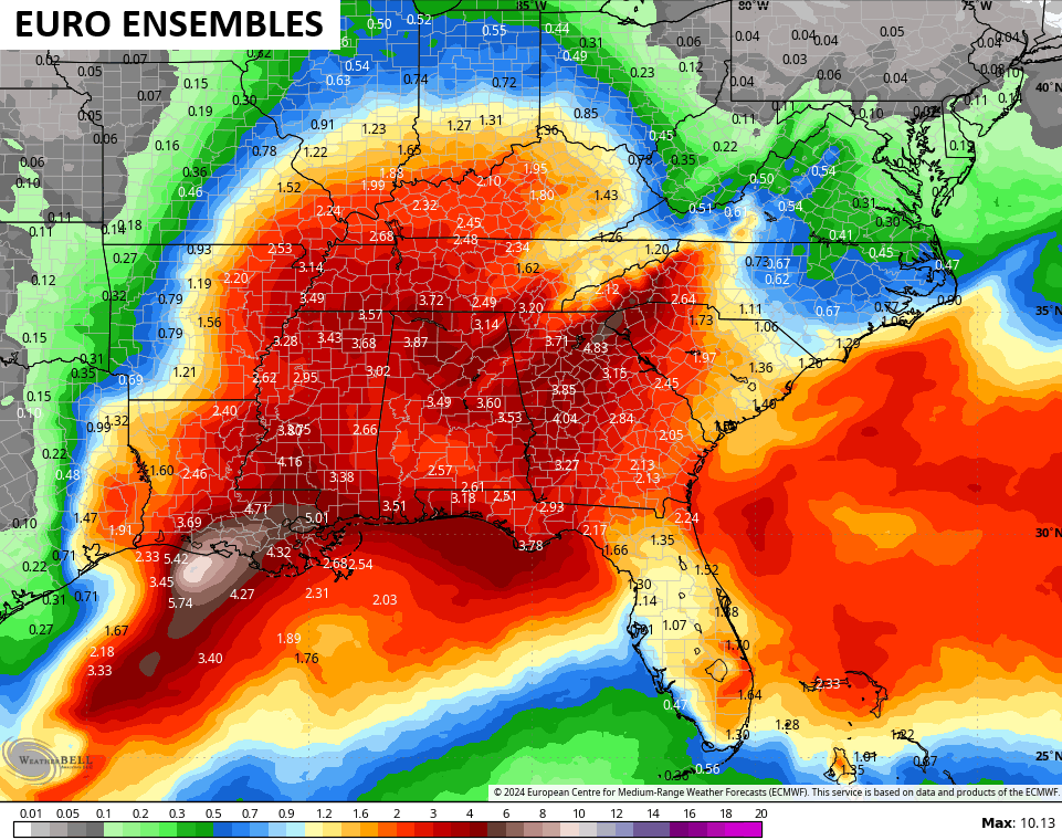
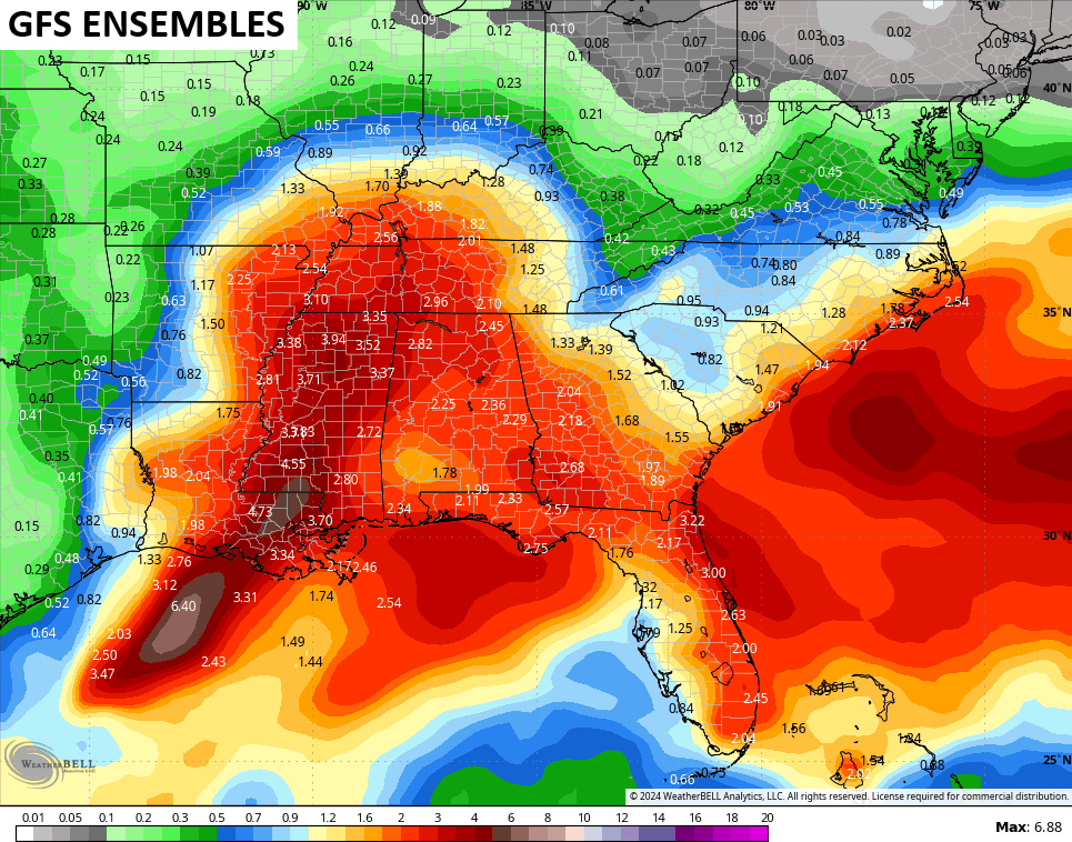
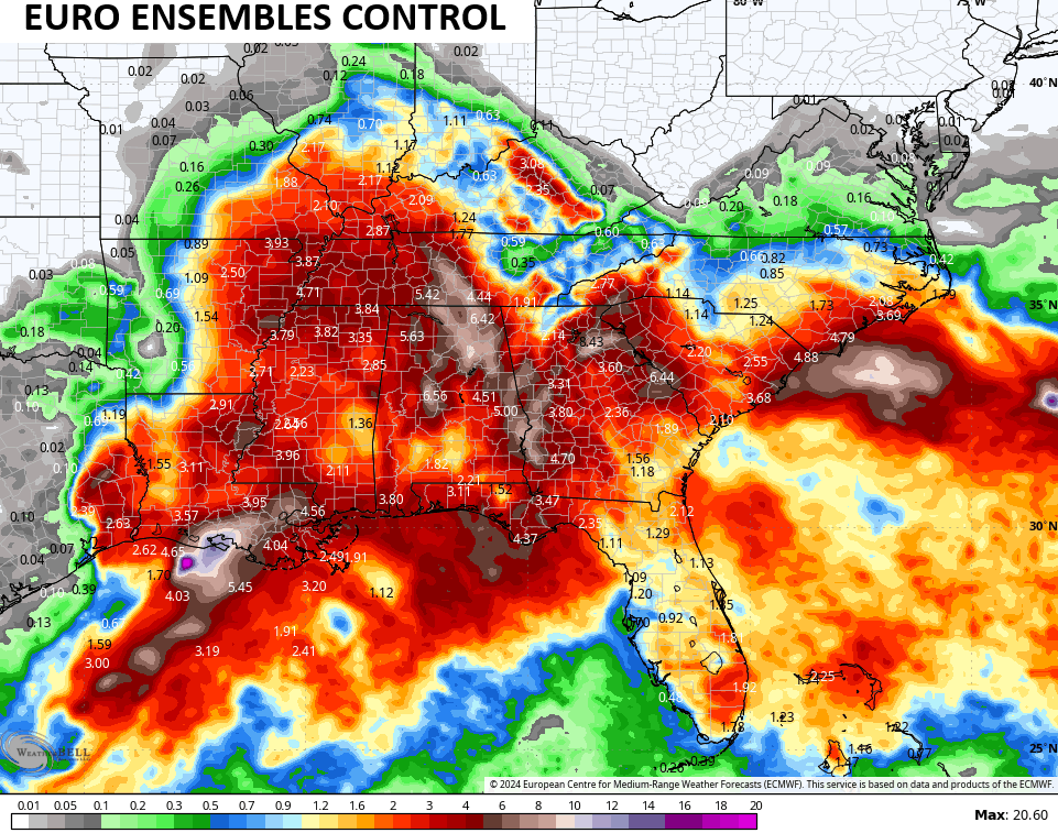
The latest from the various Ensembles match up pretty well with my thoughts…
We need to watch for a system developing off the coast of the Carolinas late this weekend and early next week. Tropical or not, it may back in from east to west and throw some rain into parts of our region.
There are two other big systems well out there in the Atlantic that may get named soon…

Have a wonderful Wednesday and take care.

Everywhere you turn this morning, the news and forecasts from all sectors can dampen one’s spirits. Not gonna let that take hold, however. Too much for which to be thankful.
Very true, and beautifully said.
So far this drought hasn’t touch what we experience back in the late 80’s that drought lasted for 2 years if I remember right.
That was a wide spread drought that lasted from December 1987 to 1989. It ended by the remanence of Hurricane Juan. Where I was in Indiana, we had an all day heavy rain event that accumulated to 5 inches in 24 hours.
Sorry, Hurricane Juan was in 1985. Very heavy rain event for the midwest. I don’t know what or when the drought in 1987 to 1989 ended. Must have been a lot of small rain events through the Winter.
as far how it ended, I don’t remember either Schroder
Hurricane Gilbert ended the 1988 drought in some states.
https://wgntv.com/news/the-drought-of-1988-was-the-worst-since-the-dust-bowl/
As is true about so many “dry spells” , it’s common to see strong regional differences, much of it terrain driven, which leads to one county having rainfall slightly below normal for the month, while an adjacent county is having moderate to severe drought condition. My weather station in central Warren County has recorded 0.03 inches of rain in the past 34 days, while the city of Bowling Green picked up 1.50 inches of rain.
What worries me is the flash flood risk from runoff due to torrential rain failing on bone dry, hard packed soil. We all need to keep eyes & ears open, especially in south and western Kentucky.