Good Thursday, everyone. The first winter system is rolling into the region today, bringing the snow showers and flurries today with a light snowfall coming this evening into early Friday. This kicks off a pattern that looks pretty wintry as we get ready to close out November and head into December.
Here’s a quick breakdown:
TODAY
- A few rain and snow showers are out there this morning with snow showers taking over this afternoon.
- With gusty winds of 30mph or greater, visibilities will be reduced at times.
- Most of the snow showers will be melting on contact.
- Temps are mainly in the 30s with wind chills dropping through the 20s.
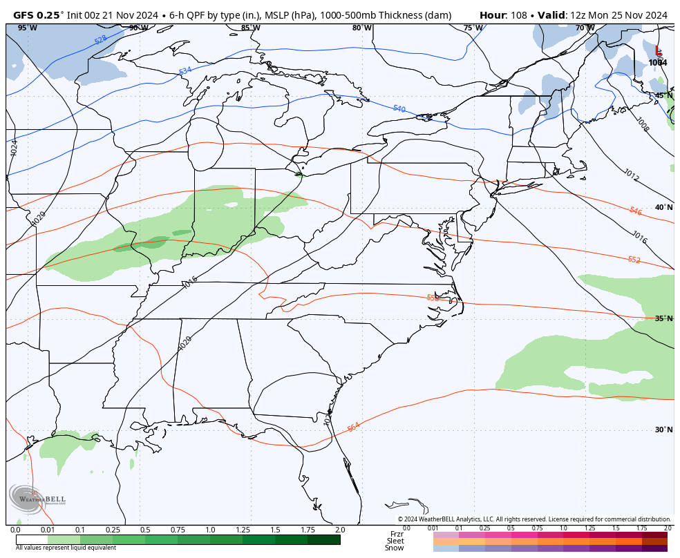
THIS EVENING AND OVERNIGHT
- Bands of light to moderate snows drop in from northwest to southeast. It will snow pretty good at times, folks.
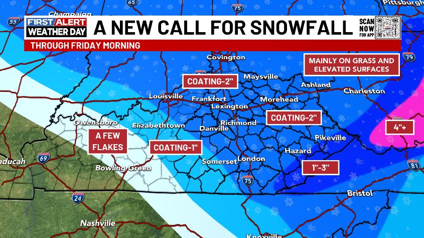
- The greatest concentration is central and eastern Kentucky.
- Snowfall is likely on grassy surface and elevated surfaces, but roads will likely just be wet.
- Lots of coatings will show up with the chance for an inch or two if everything goes just right.
- Areas of southeastern Kentucky near the Virginia border may pick up more than 2″, especially in the high mountains.
- Temps hover around the freezing mark with wind chills upper teens and low 20s.
- If temps can hit 32 or below, we will have to watch the bridges and overpasses.
FRIDAY
- Morning light snow exits southeastern Kentucky.
- A few rain and snow showers then show up for the rest of the day.
- Low clouds will be noted all day as gusty northwest winds continue.
- Wind chills once again feel like the 20s.
Here’s the New Call for Snowfall…
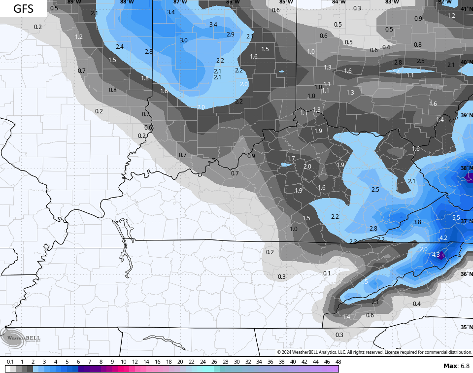
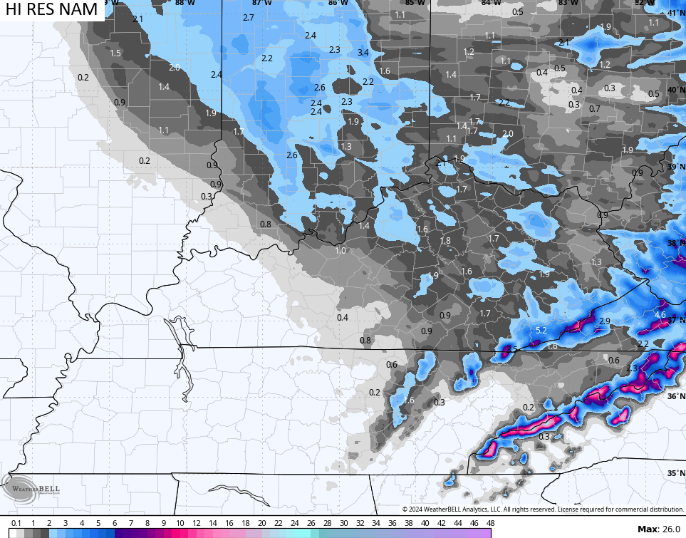
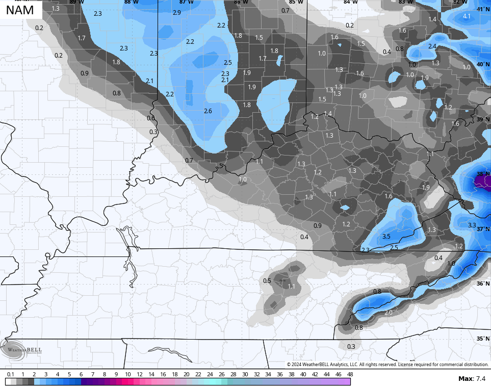
The forecast models continue to be incredibly stable with the snowfall forecasts…
Clouds will hang tough across central and eastern Kentucky into early Saturday before the clearing slowly gets in by late day. Temps are in the 40s.
Sunday looks like a nice day with highs in the 50s with clouds thickening by the end of the day. Those clouds are ahead of a cold front bringing showers in here Monday and Monday night with colder air coming in behind this.
An east to west boundary sets up across the region and it has some really cold air to the north of this. We have an increasing signal for a winter storm system or two to possibly show up over the long Thanksgiving holiday weekend. How the potential plays itself out and what impact it has on our weather remains to be seen.
The GFS is going with two systems on the latest run. The first moves through with rain and some flakes behind this as it moves through Wednesday through Black Friday…
The same model then brings a healthy winter storm rolling across the region into the northeast a day or so later…
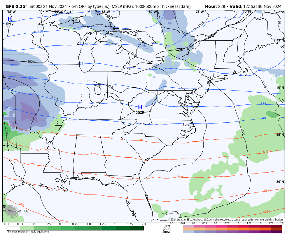
The EURO hasn’t really been seeing much of a system but that’s to be expected as the bias of the model is to really struggle with energy coming from the southwestern part of the country. That said, the latest EURO is seeing the big storm system possibilities during the Thanksgiving holiday period…
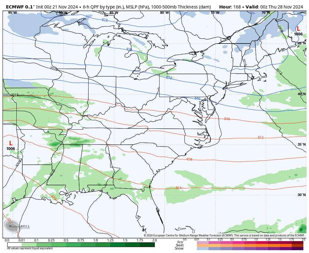
This is a pretty healthy signal that’s been there for several days and it gets louder as we get closer.
All of this is part of the pattern I’ve been yapping about. Arctic air is about to flex in a BIG way across the country in the closing week of November and that likely takes us through the first few weeks of December, at least.
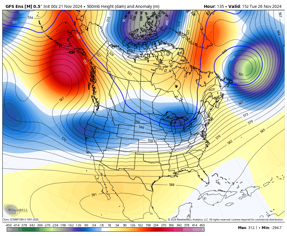
This kind of pattern turns much of the country into an ice box over the next few weeks…
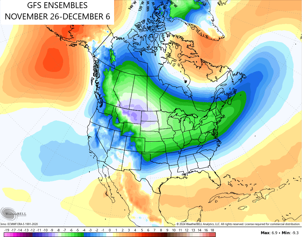
We haven’t seen a pattern like this to start December in a long, long time. You have to go all the way back to December of 2010 to find our last true cold and snowy December.
Buckle up, winter lovers.
I will have updates later today. Don’t forget to click on our Kentucky Weather Cams to watch the flakes flying across different parts of the state. Here are your tracking tools for the first blast of winter…


Have a great Thursday and take care.

119 days until Spring! 🙂
Thanks for the well detailed update Chris. I really appreciate all your hard work. Looking forward to your long ranged Winter forecast.
Have a Great and Safe Day Everyone !
That 119 days until Spring will be here before anyone knows it, as one ages Jeff, time goes faster with each year.
Not liking the snow today? Come to WESTERN KY where we’re open for business. Just drive west and you can escape the snow….we aren’t getting any snow this time around.
We’re getting our first measurable snow of the season also here in the Chicago Metro Area today, as a Winter Weather Advisory is in effect until early afternoon, in addition to a Wind Advisory all day.
An area of moderate to heavy snow is moving south from Wisconsin this morning, with 2 to 4 inches of heavy, wet, wind-blown snow forecast for much of the Chicago area, which will fall during a 2 to 3 hour time frame later this morning as temps remain below freezing. With the strong winds gusting over 45 MPH, visibility will be quite low at times.
Whatever accumulates will melt by this evening though, as temps rise to the upper 30s and the snow changes to rain and drizzle. Nevertheless, it will be exciting to see the snow falling heavily for a few hours after waiting for such a long time for our first snow.
Enjoy the first Snowfall Mike ! A typical La Nina Snow pattern setting up. Northwest to Southeast track. Western and South Central Kentucky will have to wait for an El Nino, with a positive PDO in order to have a Southern Storm track colliding with Arctic Air to produce a widespread Snowstorms, but that may not happen for many years, as the present reading on the PDO is a record negative 3.81.
Over time, the PDO has become a less reliable indicator of climate variability, a change which became evident in the late 80’s and has become the norm in recent years. Since the PDO is largely driven by changes in a perennial low pressure system over the Aleutian’s, the presence of ridging in that area has helped to keep the measure consistently negative. Part of the reason is the warming that has taken place in the North Pacific, which is causing an area of high pressure to develop over Northern Alaska and causes the path of the Polar Jet Stream to shift. This has also resulted in a strengthening of the Polar Vortex, trapping the coldest air gar to our north.
https://www.fisheries.noaa.gov/feature-story/understanding-ocean-changes-and-climate-just-got-harder
Schroeder, I figured you’d get a kick out of this:
Yesterday afternoon as I pulled into my driveway, I noticed another sign that our climate in South Central Kentucky has become flat-out weird, as my neighbor’s azalea bushes are in full bloom. I’m not talking about a few blossoms scattered here and there, but a full display that is what we would typically see in March and April…
in November!
Thanks Joe. I just learned something new about the PDO not being reliable, as it has been in the past. Great article ! I’ll not mention this oscillation anymore. Man has really mess up the Earth’s climate compared to what it was 100 years ago.
This is the first time I ever seen Azaleas and Rhododendrons bloom in October and November. I grew and sold these plants for over 40 years. If we have temperatures below zero this Winter, that will be the end of these plants.
Climate change is natural.
I hope that’s true Jeff, but the weather just doesn’t seem to be the way it use to be. I’ll quit talking about that too. I may take Meteorology off my hobby list, and pursue my other hobbies. I think that would be more healthy for my old age.
Take care All !
You can’t do that because once interested it’s very difficult to become disinterested when it comes to weather.. I mean, you can try, but I doubt it will work.
I can’t believe it’s friggin snowing a week before Thanksgiving… and it’s bone chilling cold outside right now…
Really don’t think we’re going to have a La Niña..Recently Enso region 1 +2 have warmed thanks to a huge WWB event..(Westerly Wind Bursts)..The whole North Pacific pattern has changed..Guess this is the reason we’re having this cold outbreak..Be interesting to see if this holds or we warm back up..Personally hope we warm back up but have a feeling this pattern may be with us for a while..
The current Sea Surface Temperature Anomaly chart (first link) helps to graphically illustrate the major changes in the equatorial and northern Pacific. Only a month ago, this chart showed much below normal water temperatures from South America’s west coast to the eastern Pacific, a clear La Nina signal, but today that signal is much weaker. In the north, the Gulf of Alaska shows much below normal surface temps, while the Aleutian’s to Asia are much warmer than normal, which causes a ridge to form north of Alaska. This shows up pretty dramatically in the behavior of the northern hemisphere jet stream (second link).
https://www.ospo.noaa.gov/products/ocean/sst/anomaly/
https://www.netweather.tv/charts-and-data/global-jetstream#2024/11/21/1200Z/jetstream/surface/level/overlay=jetstream/orthographic=-120.51,52.82,712
If you want a cold pac driven winter this is the change you want to see in the North Pacific..-EPO/-WPO/+PNA..Can’t remember the year but it was wall to wall cold with a -EPO..Maybe 2015..
Sounds right, it was one year, then back to abnormal.