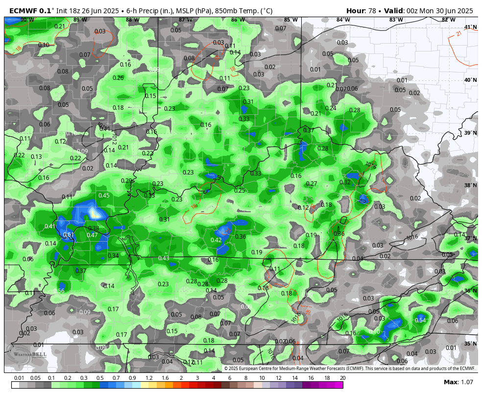
Good Friday, everyone. We are rolling into the final weekend of June with showers and thunderstorms causing a few more issues. While the storms ramp up in the coming days, the temps make a big drop to end the month and kick off July.
Pulse severe thunderstorms caused all kinds of issues throughout central and eastern Kentucky Thursday afternoon and evening. Areas of significant wind damage showed up, with Lexington taking it on the chin. Flash flooding was also a big issue for Lexington and several other areas.
Here’s a sample of the damage from my @Kentuckyweather Twitter/X feed…
Wow. What a thunderstorm! Finally have a warning!!! Fence was taken down. Wind was brutal!!!! #kywx @Kentuckyweather @JimWKYT pic.twitter.com/XRzWudsV69
— Lindsay Ames (@Linzay2122) June 26, 2025
@Kentuckyweather @NWS Barleys Pass in Lexington. pic.twitter.com/9ELqtXlCDF
— Paul Head (@Paulhead31) June 26, 2025
@Kentuckyweather @JimWKYT Trees & tree limbs down all over the place. #KYwx pic.twitter.com/Dqim43KsFY
— TW☎️ (@KYTW911) June 27, 2025
Result of a thunderstorm in Lexington Kentucky that wasn’t warned
(Not my property) @Kentuckyweather pic.twitter.com/9ZKltPI0hb
— Y0TELEX (@Y0TELEX) June 26, 2025
Courtesy of Dennis Hutchinson, this is Court Street in Downtown Prestonsburg KY @Kentuckyweather pic.twitter.com/4JKr2KBxPj
— Joseph Brooks (@JosephBrooks20) June 26, 2025
Storms going up out there today can produce similar results as the atmosphere is primed for pockets of wind damage and flash flooding. This stuff isn’t widespread, so I’m not sure if the Storm Prediction Center will have a Marginal Risk out, but they should…

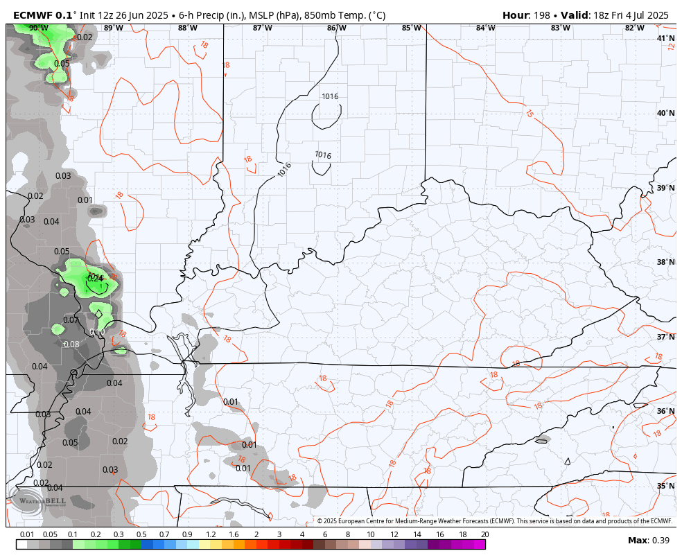
Those showers and storms carry us from Monday through Tuesday night as a fairly strong cold front moves in. This brings better weather in behind it…
As of now, much of Wednesday through the 4th of July on Friday appears to be dry. I say “appears” because the models turn stormy into the holiday weekend and try to get some of that action into the west for the 4th.
This animation from the Euro shows rounds of showers and storms from late on the 4th all the way through the 11th…
That setup may very well fire off some hefty complexes of storms that create more flash flooding issues.
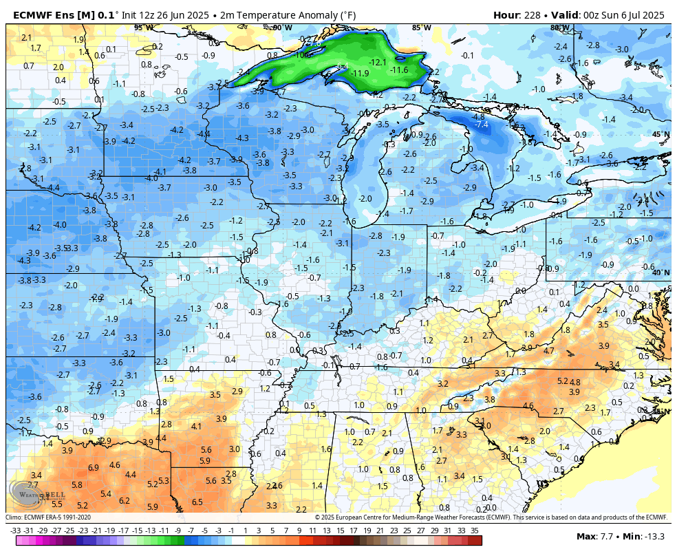
Temps for the 4th of July week return to normal and even a bit below normal. The EURO Ensembles suggest that hangs tough into week 2 of July…
I leave you guys with your daily dose of storm tracking tools…


Current watches

Possible Watch Areas

Make it a fantastic Friday and take care.

I think the cool down is overblown as is precipitation.
Who actually knows.
It’s so crazy how FAST those pulse storms can happen. When you watch them on radar it’s like nothing there then suddenly, it just explodes… It was like 94 and full sun and then suddenly dark/stormy… I was really surprised with this one as usually pulse storms have tons of close lightning strikes and loud thunder…I was seeing tons of wind, torrential rain but I only heard very distant thunder…
Mark, I’m on the south east side and we heard lots of loud thunder but we only had .02 rain and just a nice breeze. It looked like the entire city was covered with that storm and it cut off right over us.
Was this storm, that hit North Lexington a Tornado or a Microburst ? Things have really changed with the weather. It use to be just late afternoon and evening thundershowers. The weather has caused soo much damage to areas of the state this year, and I don’t see how things will get back to normal in the times we live in.
In my opinion, what’s going on with the weather can be traced to the persistent cold coastal waters in the east Pacific. An on going negative PDO, which translates that La Nina is still with us. NOAA said that we will be in ENSO / neutral through the upcoming Fall and Winter, but when will it reach neutral ( 0.00. )
Articles I found on the PDO / negative and ENSO / neutral. Expected to be another dry uneventful Winter for a large area of the CONUS :
https://climas.arizona.edu/sites/default/files/migrated_media/pdffanov12enso-neutral_5.pdf
Climate Prediction Center forecasts an 80% chance of ENSO-Neutral persisting through October, and a 42% chance of La Nina in the November to February timeframe. In other words, rinse and repeat…again.
Another factor for this coming Fall and Winter is the Polar Vortex has moved into Northern Europe, and is likely to stay put through the Winter months. This may be the most boring Fall and Winter Ever. We shall see.
OK wait.. Last winter wasn’t a bad winter…. At least here we had right at 2 feet of snow Jul-Jun… Not the best winter but certainly better than some other winters I’ve seen.
“Verify” has been our Word of the Week (thanks to Chris). I’ve been trying to use it in everyday conversation. So yesterday’s pulse storm that dumped rain and created wind damage, “with Lexington taking it on the chin”? It didn’t “verify” at our house in south Lexington (Lansdowne). We had 13-15 drops of rain and gusty breezes.
Another reason why the weather may be the way it is at this time, the Magnetic North Pole is moving from the Canadian Arctic towards Siberia at a rapid rate :
https://www.google.com/search?q=where+is+magnetic+north+pole+now&sca_esv=000223f181a12c46&sxsrf=AE3TifM2yM-V2lDwHvAyvFYOUeNrr1PQ2Q%3A1751031217549&source=hp&ei=sZ1eaL3EH6KnmtkP2bXt-Ac&iflsig=AOw8s4IAAAAAaF6rwTNqycj2UHOTeI5Qp3Q8_w4l3ZCW&oq=where+is+magnetic+north+pole&gs_lp=Egdnd3Mtd2l6Ihx3aGVyZSBpcyBtYWduZXRpYyBub3J0aCBwb2xlKgIIATIFEAAYgAQyBRAAGIAEMgUQABiABDIFEAAYgAQyBRAAGIAEMgYQABgWGB4yBhAAGBYYHjIGEAAYFhgeMgYQABgWGB4yBhAAGBYYHkiQmQJQAFiP1gFwAHgAkAEAmAGFAaAB1xeqAQQxLjI3uAEByAEA-AEBmAIcoAKyGcICCxAAGIAEGJECGIoFwgIKEAAYgAQYQxiKBcICEBAAGIAEGLEDGEMYgwEYigXCAhEQLhiABBixAxjRAxiDARjHAcICCxAAGIAEGLEDGIMBwgIOEC4YgAQYsQMY0QMYxwHCAhQQLhiABBixAxjRAxiDARjUAhjHAcICChAuGIAEGEMYigXCAg4QABiABBixAxiDARiKBcICCBAAGIAEGLEDwgIHEAAYgAQYCsICChAAGIAEGLEDGArCAgsQLhiABBjHARivAZgDAJIHBDAuMjigB8y2AbIHBDAuMji4B7IZwgcGMi0yNS4zyAfBAQ&sclient=gws-wiz
Another factor why the climate is changing is Solar Cycle # 25.
I’d love very little snow this winter.