Good Thursday, everyone. It’s another winner of a weather day across Kentucky with pleasant skies and pleasant temps. Once into the weekend, we kick off a much more active pattern featuring a lot of back and forth with temps. Beyond that, some serious winter is lurking.
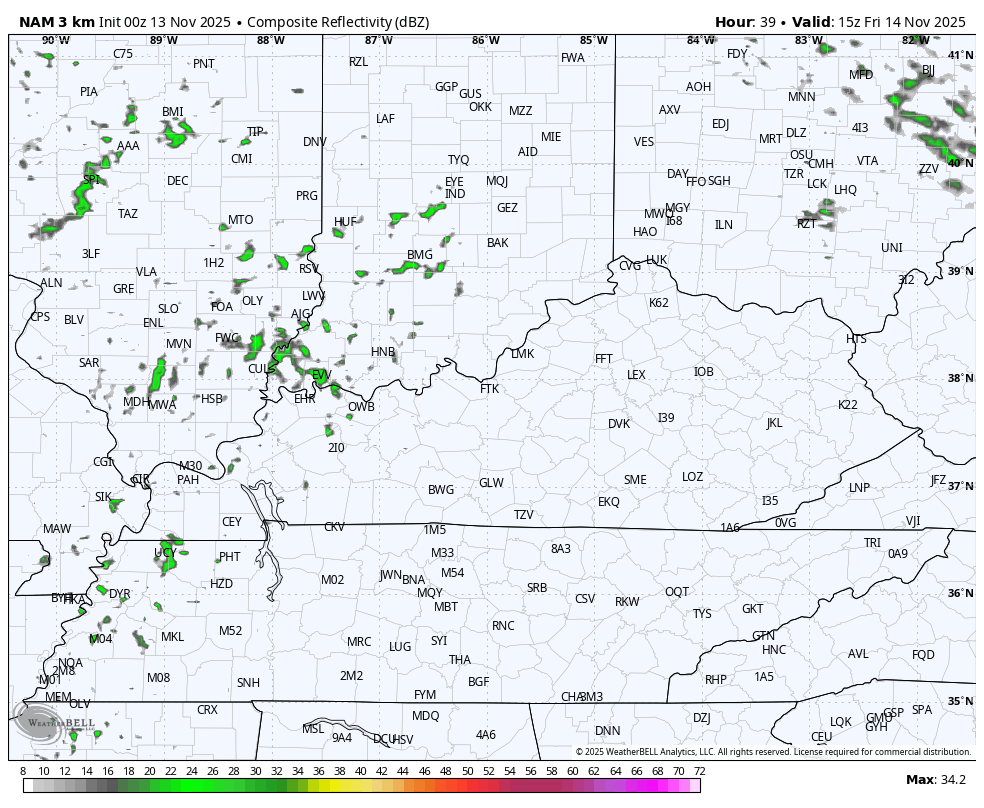
Temps today range from the middle 50s to the middle 60s with a partly sunny sky. Even milder air surges in from the southwest on Friday and this may have a few sprinkles or showers along and ahead of it later Friday into Saturday morning.
You can see this scattered action on the future radar from the Hi Res NAM…
Saturday’s temps range from the middle 60s to low 70s across the state with a strong southwest wind ahead of a cold front dropping in Saturday night and Sunday. This front doesn’t have much moisture but will knock our temps way down for Sunday and Monday.
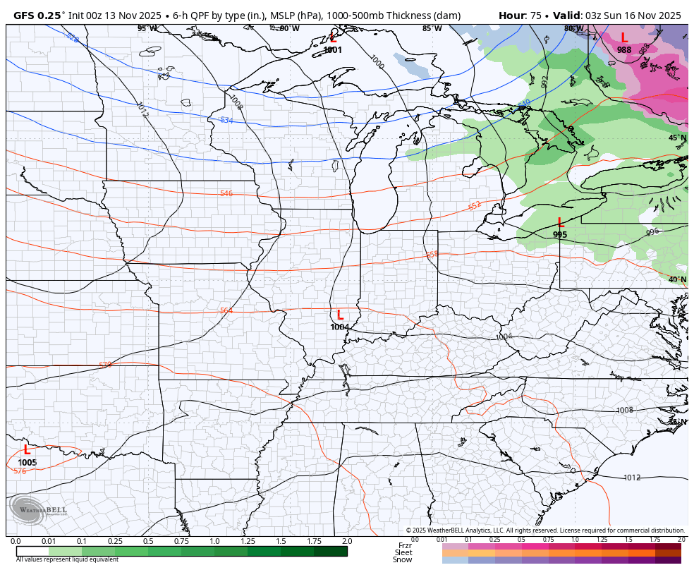
Low pressure then rolls in from the west with some chilly showers later Monday into Tuesday. The GFS looks like this with both systems…
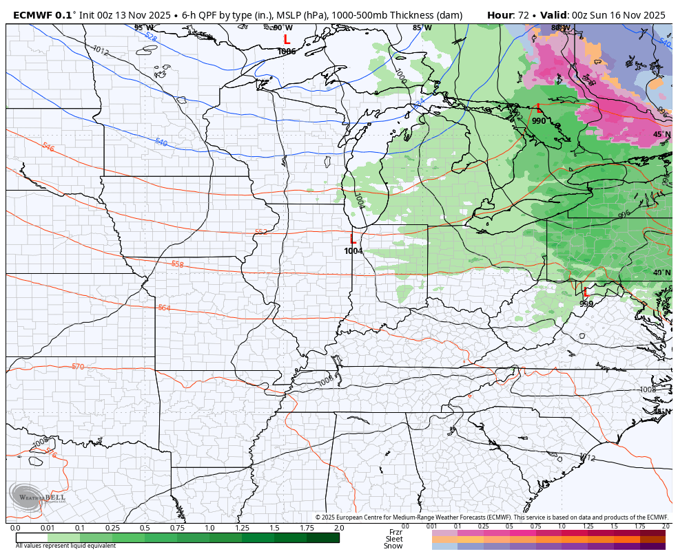
The EURO is a little stronger with both…
Several big storm systems are likely to roll from southern Plains toward the Great Lakes. The models are going to vary from run to run on how to handle each of these, but I continue to maintain we have to be on guard for severe storms and the potential for a lot of rain next week into the weekend before Thanksgiving…
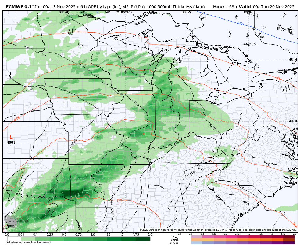
What happens in a pattern like this is that each storm tracks farther east as the cold pushes a little more and a little more before it finally takes hold around or just after Thanksgiving.
I’ve been talking about an early start to winter since back in the summer and haven’t blinked on this since. The signals continue to line up for significant blocking developing later this November and Into December, giving us the potential for early season arctic blasts.
The EURO Weeklies typically have a hard time seeing troughs and cold, so the fact they have been all in on December is telling. As a matter of fact, they are growing bolder with the colder as we get closer.
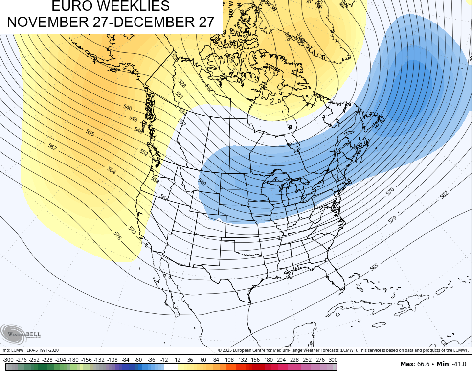
This is a 30 day height anomaly map from the 101 members of the EURO Weeklies. Seeing a trough like this in a 30 day mean is something…
The Weeklies don’t really give us a good idea of temp departures until we get much closer, but they are already seeing coast to coast cold during that 30 day window…
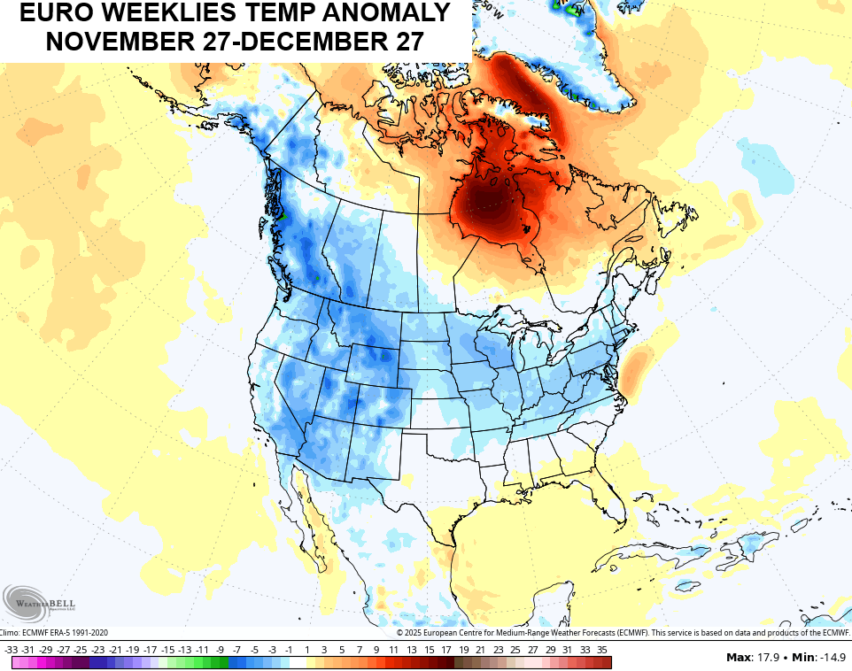
That’s very unusual to see for a 30 day average on any seasonal, let alone the EURO Weeklies.
They continue to show ample snow opportunities…
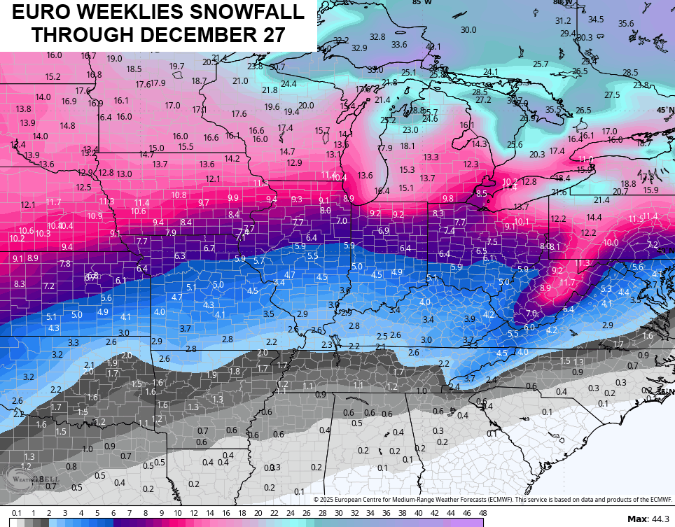
This looks like a pretty active storm track into December which may very well mean we find a WST or two before we get to Christmas.
I’ll have another update later today so check back. Have a great day and take care.

Winter can go away after Christmas for all I care.
The CPC has released their November ENSO report, which signals a 51% chance that a weak La Nina will continue through Dec, Jan, and most of Feb. We will see a transition to ENSO-Neutral in late Feb, which based on historical records, increases the likelihood for above normal severe weather during spring of 2026.
https://www.cpc.ncep.noaa.gov/products/analysis_monitoring/enso_advisory/ensodisc.shtml
ENSO / El Nino by June- August 2026, but will the PDO phase to positive ? The last El Nino, a few years back was cancelled by a negative PDO. Had no impact on the weather pattern across the CONUS.
I still say we will have a YO / YO Winter, with below normal Snowfall. Also, a very stormy late Winter and Spring. Hope I’m wrong folks.
https://climateimpactcompany.com/november-2025-enso-outlook-short-lived-la-nina-followed-by-el-nino-during-middle-third-of-2026-2-2/
Here is the link to the summary of the lake snow event across NW Indiana and NE and east-central IL Sunday night into Monday morning. NW Indiana and east-central IL by far received the most snow out of this, sparing the Chicago area. https://weather.gov/lot/2025_11_10_LakeEffectSnow
Thanks Mike, for sharing the Lake Snow totals. I plan to follow the Great Lake Snows this comming Winter, as this is where the most Snows will occur. One can clearly see where most of the Winter weather will be in 2025 -26. The Northern States will be areas to track huge Snowstorms. The Southern States will be under warm High Pressure most of the Winter. Kentucky is on the fence, like most years. I just hope we don’t have an Ice Storm, like we had in 2009. Over a month without electrical power.