Good Sunday, everyone. We have a really wild weather ride that’s upon us as Spring meets Winter, giving us everything from severe weather to snow in the next 24 hours. The severe threat out there this evening is taking center stage.
Here’s a breakdown of what to expect:
TODAY
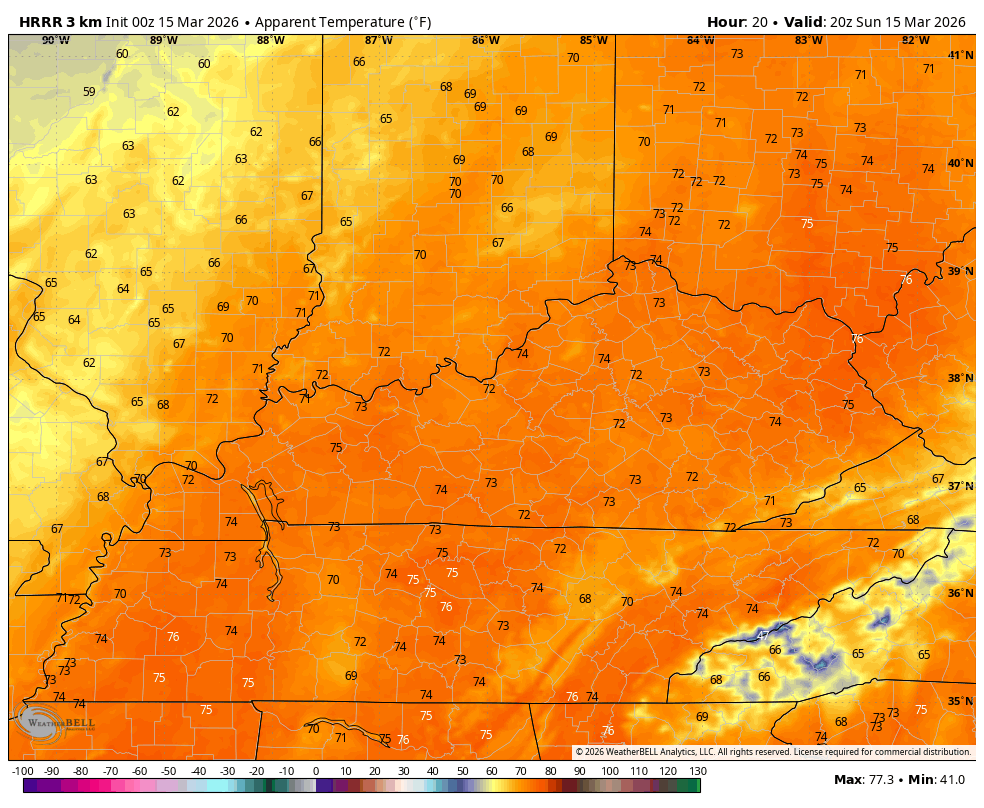
- High temps surge into the 70s across all of Kentucky.
- Winds will begin to crank throughout the day and should reach 40mph to 50mph at times this afternoon and evening.
- A powerhouse storm moves from the Plains to the Great Lakes, bringing a cold front into the west later this evening.
- This front will spawn a line of severe storms targeting western Kentucky this evening.
- Damaging winds and a few tornadoes will be possible in the west during this time.
TONIGHT
- The line of severe storms races eastward into central and eastern Kentucky through the wee hours of Monday morning.
- Damaging winds and a few tornadoes will be possible in central Kentucky.
- This line weakens as it moves into the east but may still produce some wind damage.
- Temps ahead of the front are 65-70 with a drop of 20-30 degrees in an hour once the front passes.
- Snow showers and flurries will be noted behind this boundary.
MONDAY
- Temps continue to drop from west to east with most areas staying in the upper 20s and low 30s.
- Wind chills will make it feel like the teens.
- Snow showers and flurries will be common, especially across central and eastern Kentucky.
- A few snow squalls can’t be ruled out and one or two of these may have a little thunder.
- Some light slush may show up on grassy and elevated surfaces from time to time.
- I’ll be watching for a band of enhanced snows trying to develop across eastern Kentucky. If that happens, a slushy thumper would be possible.
MONDAY NIGHT
- A few snow showers and flurries continue with light accumulations possible.
- Temps hit the teens, meaning the chance is there for a slick spot on bridges and overpasses.
- Wind chills reach the single digits by Tuesday morning.
Here’s a look at how all this shakes out on the future radar from the HRRR that runs through 8pm Monday…
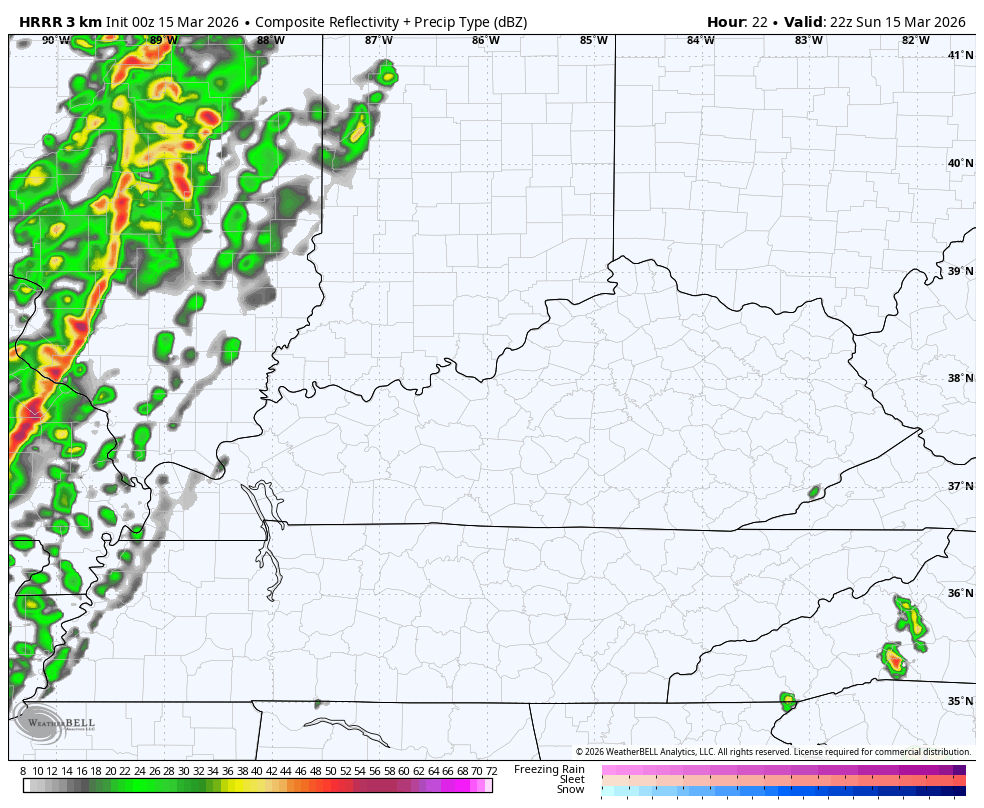
The Storm Prediction Center continues to put the severe weather bullseye on top of our region with today’s Severe Weather Outlook…

The risk for a few tornadoes shows up within this line of severe storms with the greatest chance in the west…

Damaging winds continue to be a MAJOR threat across western and parts of central Kentucky…

The temp crash is spectacular, especially when we factor in the wind chills. These numbers start this afternoon and go into early Monday evening…
Tuesday’s highs are in the 30s before we start to bounce back on Wednesday. There’s a slight chance for a rain or snow shower early Wednesday on the leading edge of milder winds. Those winds take us into the 60s for Thursday then 70 for Friday with a shot at the 80s next weekend.
Another update comes your way later today. Until then, here are all the storm tracking tools you need to start the week…


Current watches

Possible Watch Areas

Make it a sensational Sunday and take care.

A brief cool snap with light snow? No big deal.
I Think There Will Be More Wind Than Rain When The Front Arrives Late Tonight, Or Early Tomorrow Morning. Right Now, We Have Entered The ” Dry Slot ” Of The Low Pressure System Which Is Way To Our North. I Would Rather Be North Of The Low Pressure System In The Areas That Are Receiving The Heavy Snows.
I’m Surprised That We Are Not In A ” Red Flag ” Warning, Because The Forest And Fields Are Very Dry, And Any Fires That Break Out With The Awful Southwest Wind Will Spread Quickly. Whoever Is In Charge Of The Issue Of Warnings, Either Doesn’t Know, Or Doesn’t Care.
The nearest Red Flag Warnings are in OK and TX. Because of the heavy rains that are predicted to move through your region later on today, that’s probably why there hasn’t been a RFW issued for KY or nearby states.
The snow certainly won’t be a big deal for you guys in KY compared to what we’ll be getting here in Northern IL. There’s a Blizzard Warning in effect for NW IL, a Winter Storm Warning in effect for Northern IL, and a Winter Weather Advisory in effect for parts of NE IL, all for later tonight through Monday morning. Meantime, it’s near 60 degrees here in the SW Suburbs with possible severe weather expected later this afternoon throughout the Metro Area, as we are in the Slight Risk area. Also, there’s a Wind Advisory out for today. And by Monday night/Tuesday morning, wind chills are expected to be near 10 below zero. Good grief!
Mike, A Tornado Watch Is Out For A Large Area Of Real Estate Here In Kentucky. A Lot Of Watches Have Recently Turned To Tornado Warnings. Hope We Make It Through The Night, But It Looks Bad Right Now.