Good Thursday and welcome to October. The month is starting out on a very windy and very warm note, but things will change quickly as a cold front drops in on Friday. This boundary likely slows down, allowing a few more showers to continue into a cooler weekend.
Temps today reach the low and mid 80s in the east with near 90 in the west. Southwest winds will be very gusty, especially this evening and may top 30mph at times. This is ahead of a cold front dropping in here on Friday.
Showers and some rumbles of thunder will be possible from northwest to southeast throughout the day. We may very well have a near 25-degree temp spread showing up from one side of this front to the other. Temps drop through the 60s and may hit the upper 50s behind the boundary. Here’s the future radar from the Hi Res NAM from 8am Friday to 8am Saturday…
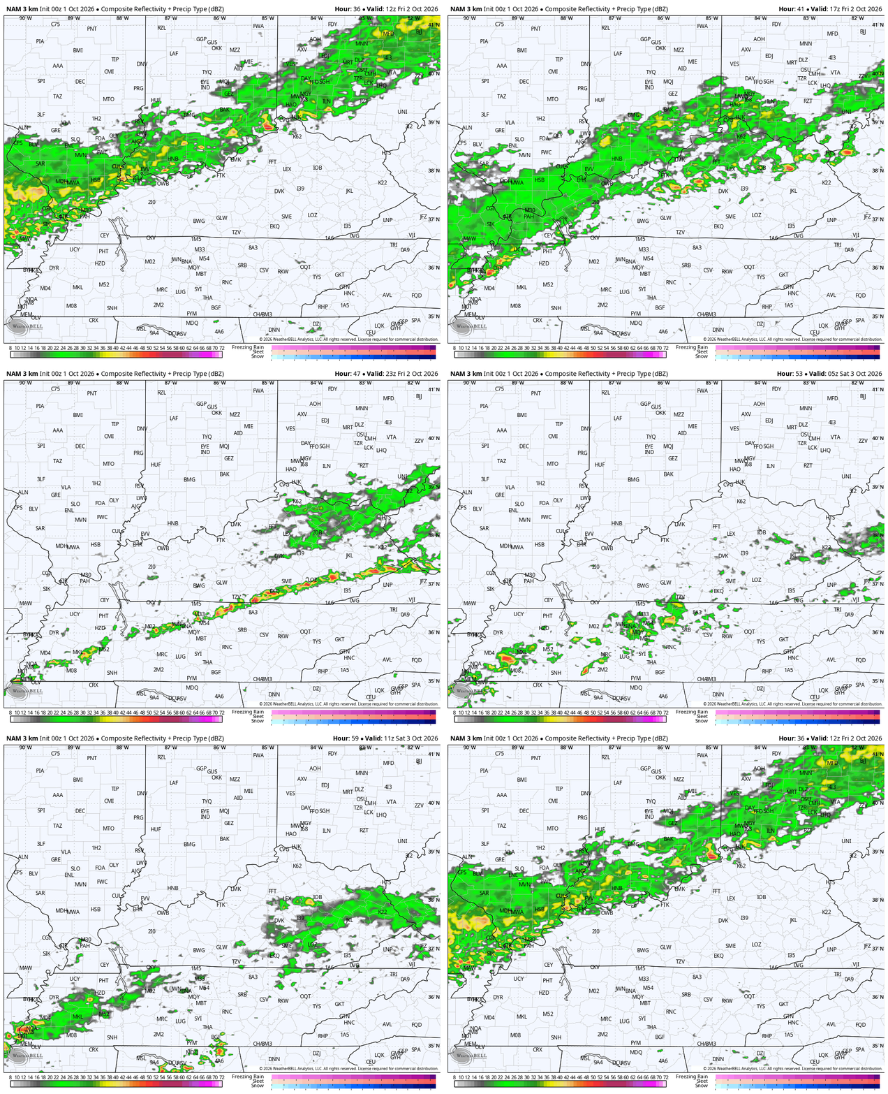
This front then slows down across the Tennessee Valley on Saturday with a couple of areas of low pressure moving along it. The first comes Saturday with the next one due on Sunday. Both of these will bring showers across parts of Kentucky.
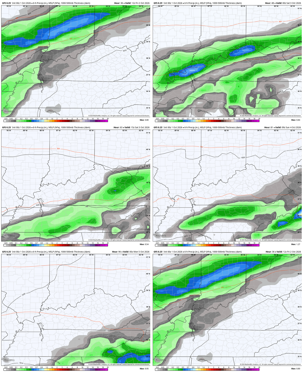
How far north these things get continues to be a work in progress. All the American Models have been really poor this year and are REALLY bad with how they handle the weekend setup as they have been way too far south and southeast. They are correcting back to the northwest and that’s something we usually see with them in the winter months, not early October, but here we are.
The new GFS is finally seeing everything I’ve described. This animation runs from 8am Friday through 8pm Sunday…
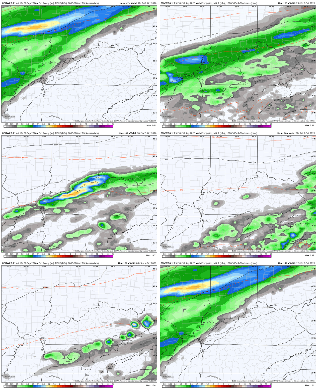
The EURO has been saying this exact thing for several runs in a row now…
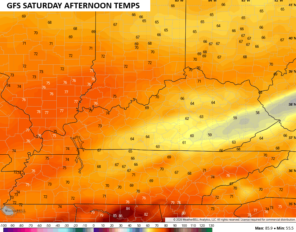
As I’ve mentioned, any areas seeing clouds or showers for most of the day on Saturday could stay in the upper 50s to low 60s. The models are seeing that possibility…
The patchy frost threat remains for Monday night as lows drop into the mid and upper 30s for parts of Kentucky. Next week as a whole looks super nice across our region.
In the medium range, we are seeing more and more recurving tropical action out of the Pacific and that typically corresponds to dips in the jet stream across the eastern US.
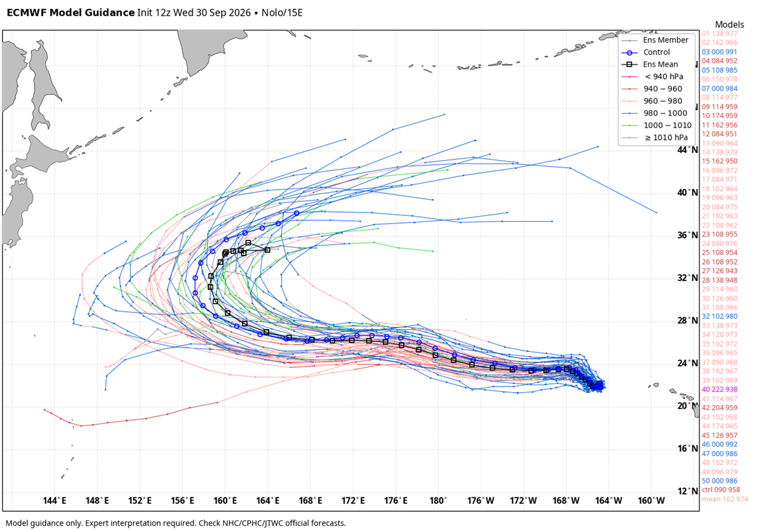
Hurricane Nolo is now well west of Hawaii and is actually forecast to recurve…
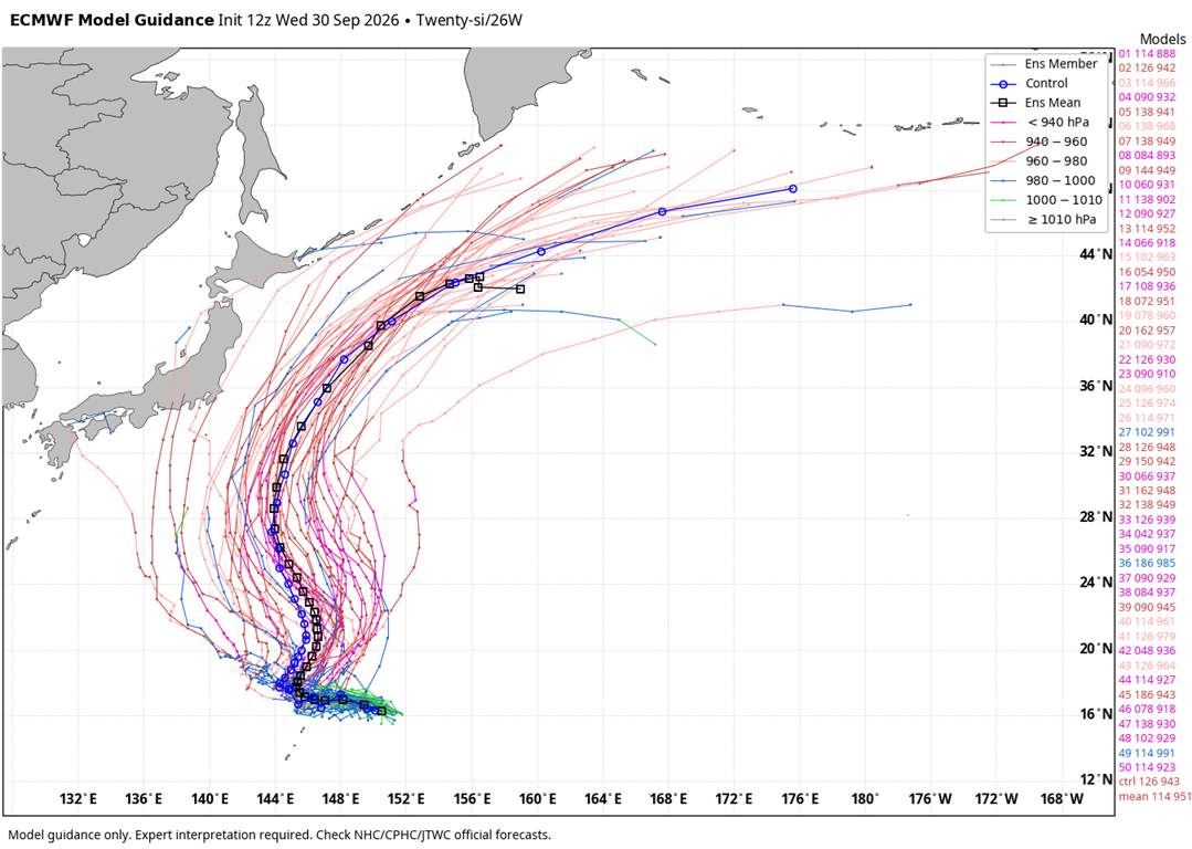
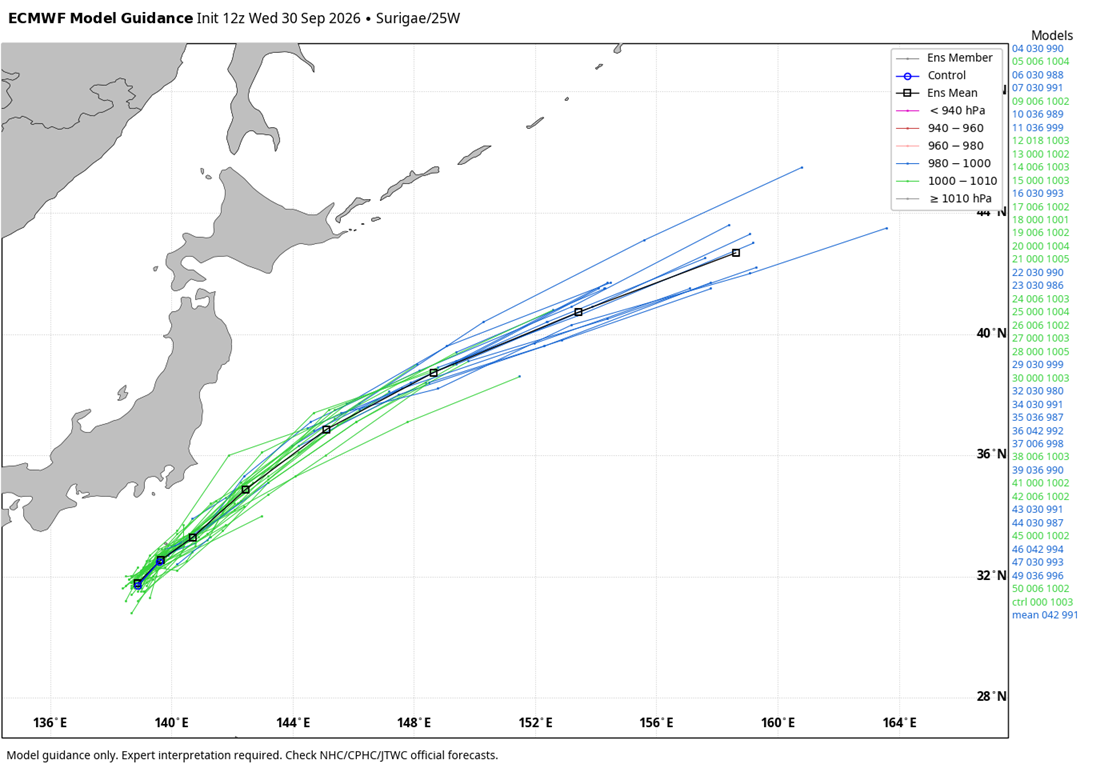
The western Pacific is where we usually watch for recurves and it appears we have two more there…
Unfortunately, we can’t get the operational models to stop spitting out false tropical systems down in the Gulf. Every time we see a model doing that, you can pretty much write off what it’s showing from that point forward.
I mean, we STILL haven’t had a hurricane in the Atlantic, the latest on record in the modern era.
As always, I leave you with your daily storm tracking toys…




Current watches

Possible Watch Areas

Make it a terrific Thursday and take care.

Models aren’t bad just because they don’t tell you what you want to hear.
You know your heating days are over and I know you don’t want to hear that either
Incorrect take.
I know darn well it’s fall. Spare me your nonsense.
Hope this rain verifys we should do need it.
We don’t need floods.
The likelihood of south central Kentucky seeing any meaningful rain during this transition is very low. Throughout Warren County the ground is parched and fire danger is high, with burn bans in effect in Warren and the surrounding counties.
The trend for Pacific tropical systems to recurve to the north then northeast is definitely present, and there is a greater likelihood that as these storms curve away from Japan, they will maintain their strength or even possibly intensify. This is due to the presence of abnormally warm sea surface temperatures in the northern Pacific, which can be see on the most recent SSTA chart. The low pressure area over the Pacific south of Alaska continues to strengthen, and will tend to push the arc of the polar jet stream farther north above Alaska. The path of the jet will then curve to the south and east, where it will be positioned to feed cold air into the upper plains and midwest.
https://www.ospo.noaa.gov/products/ocean/sst/anomaly/
Let’s see if the PDO responds to these recurving typhoons..According to noaa it sits at-1.22….Would like to see these recurving typhoons displace the warm pool of water off the coast of Japan eastward..Would it affect the ridging and jet stream in a positive way for winter in ky..I think it would..
I’ve been hearing more meteorologists take the position that the increased warming of the atmosphere and oceans is causing the PDO to lose its effectiveness as a predictor. I also believe that atmospheric warming is one of the reasons why it is increasingly difficult to lock in on reliable analog years. Looking back a month or two at the SSTA charts, it does appear that there is some movement of the warm patch towards the east.
For September, the average temperature at Chicago’s O’Hare Airport was 70.1 degrees, which is 3.8 degrees above normal and ties for the tenth warmest September ever.
O’Hare recorded 3.70 inches of rain for the month, but here in the SW Suburbs 40 miles away, 6.66 inches of rain fell, of which 6.43 inches came from September 17th – 30th.
Other than the heavy rainfall, there was no severe weather at all in the Chicago Metro Area for the month, a very welcome break from an extremely active year for severe weather and tornadoes here.
Mike, I believe that break may end by the second half of fall, as the super El Nino ratchets up it’s influence. What’s really got my eye is what happens at the beginning of 2027. Supposedly, El Nino is forecasted to phase into ENSO Neutral during the spring, and historically, a phase to neutral in spring increases the chances for severe weather. This would would line up with my current favorite analog years of 1997, 1998, and for those living in the Bowling Green area, the spring of 1998 was definitely memorable!
What Are Heating and Cooling Degree Days https://share.google/nh3WUI4Z8QRx2cDGI
Heating and cooling degree days define how much (in degrees) and for how long (in days) the outside air temperature deviates from a standard base comfort temperature, which is typically 65°F in the US. I suspect that the comfort temp will be increased before long.