Happy New Year! We’ve made it through another year together and our now 10 year old weather family continues to grow. I started my first blog back in 2004 and it has grown into the full blown weather site you see today. I’ve said it time and time again… you guys are the backbone of the site. Thank you! Here’s to 2014 being our best year yet as a weather family.
Ok… enough of the mush. 🙂 We actually have some serious weather possibilities over the next week. I’m tracking two snow systems and the increasing threat for the coldest air we’ve seen in years. Let’s get to it…
I have no changes on what I think happens with the Thursday snow system. Here are a few thoughts on it…
– Low pressure is showing up a little better with each model run as it tracks across the Tennessee Valley on Thursday.
– Most of the precipitation associated with this low will fall in the cold air to the north and west of the track. A touch of a mix will be noted at the very beginning of the snow… especially in the southeast.
– A period of moderate snow is likely to work across the state from west to east behind this low. Snow showers and squalls will then kick on during the late afternoon and evening hours.
– A general 1-3″ will be possible in central and eastern Kentucky. I think lighter amounts will be noted in the west. Can some areas do better than the 1″-3″ ? Maybe. I will have a new snow map out later today.
– Temps will tank toward the high single digits and low teens by Friday morning. Gusty winds could give us dangerously cold wind chill values Thursday night and early Friday. Check this out…
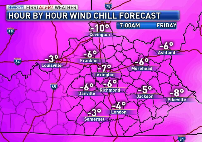
That’s just brutal, but may be just the tip of the iceberg… no pun intended.
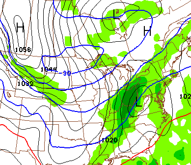
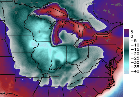
A MAJOR blast of arctic cold will enter the country this weekend and dive toward our region by early next week. There is likely to be some kind of winter storm develop ahead of this from Sunday into Monday. The exact impact of that storm on our weather will be ironed out in the coming days. I do expect it to put snow on the ground ahead of the north pole moving in. The GFS is picking up on the storm…
 The air showing up on the GFS is crazy cold and backs up what the European and Canadian models have been saying for many days, now. You may freeze just looking at this…
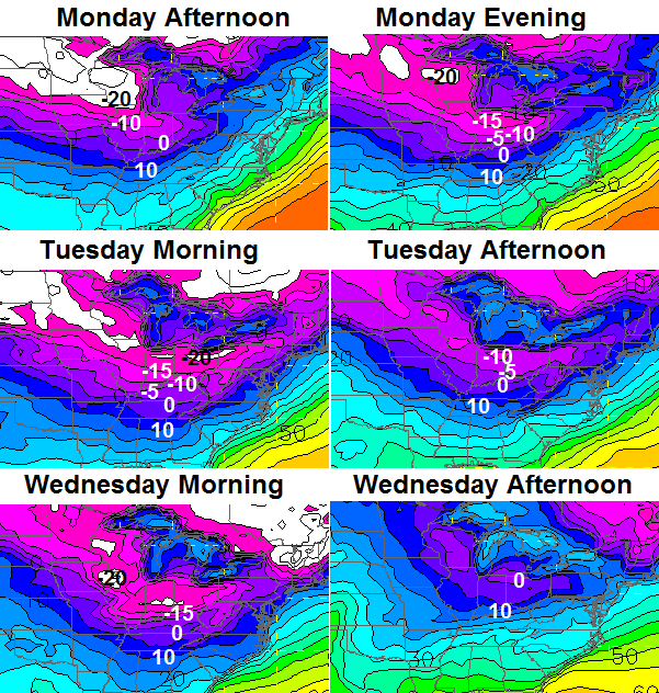
If we are to believe the GFS… temps fall from the teens through the single digits on Monday and wind up below zero by Tuesday morning. Highs only reach the single digits in the south and stay below zero in the north. Wednesday sees temps well below zero to start. That’s what the GFS is saying… but, I can’t really argue with it at the moment. The pattern is THAT extreme.
The Canadian model is a little slower and deeper with the storm ahead of the absurd cold…
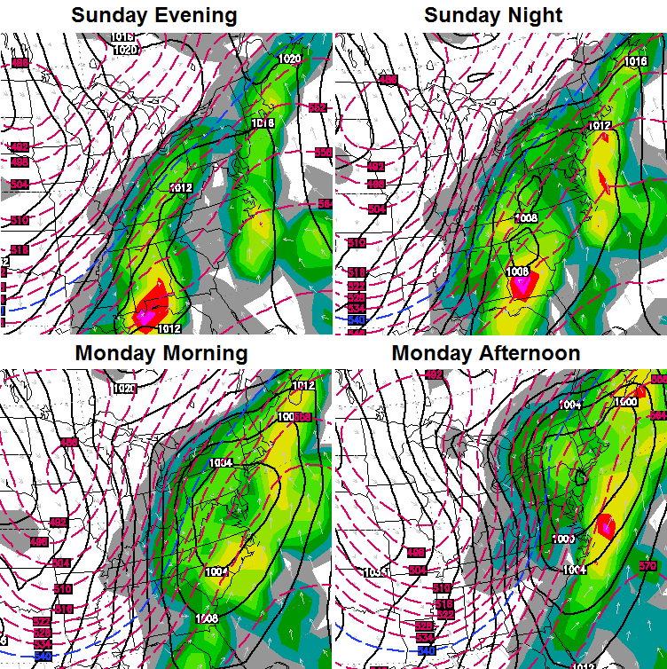
That’s similar to what the European Model has been showing in recent days. Check out the low temps coming behind that storm on the Canadian…
 Again… every single model takes our temps below 0 at some point early next week. They just vary on how low the numbers can go. We will figure that out as we go forward, but a lot of it will depend on how much snow we can put on the ground before the arctic opens up. We an only get the truly extreme cold numbers with snow on the ground.
Something else to take into consideration… wind chill numbers. This setup will have quite a bit of wind with it and that could give us ridiculously cold wind chill numbers through the middle of the week.
I will have updates later today. Happy New Year and take care.

That will be awesome if we can get about a foot of snow to go with it. Thanks Chris!!!!
Is the euro still showing a big snowstorm & below zero numbers next week.
Happy New Year, Chris! Thanks for all you do!
Chris,
Happy New Year and thanks for staying ahead of things for us!
FYI, has anyone reported an issue between the newer iPads and the WKYT charts on your site?
When ever you post using WKYT charts, my browser on my iPad 3 crashes, presumably as the WKYT chart loads. It doesn’t matter what browser I’m using on the iPad, they all crash.
Interestingly enough, there are no issues when I view the WKYT website directly or if I use my older iPad 1, which can’t run the newer iOS software. Your site with WKYT graphics also runs just fine on my iPhone 5.
So the issue is probably unique to my iPad setup or something to do with the newer iOS running on an iPad.
Thanks!
I remember the very first blog 10 years ago..wow time flies….hope we get some snow down here in Tennessee as well…happy new year…
thank you so much Chris. been following for 4 years and it’s a great blog-good peoples!
sounds like a bunch of snow and cold tracking on the way.
Happy New Year
Thanks Chris for the update! And for all you do! Hopefully we can see some snow ( a big un) this winter! Have a great New Years Day, everyone!
When is the snow supposed to start in the southeastern part of the state on Thursday?
Chris Happy New Years to you and your family. Happy New Years to all of Chris’s followers as well. Been visiting/commenting for 4-5 years now. Don’t comment as much in the spring/summer as I do winter, but it is the first site I visit every morning. It is fun to follow the comments and sometimes it can be annoying. Kind of like Kentucky Winters, you never know what you might get.
Thanks again and HAPPY NEW YEAR! THINK SNOW!!!!
Looks like Jackson office has dropped there totals from last night..Was in the 4 inch range previously’..Maybe they will up them again as the day goes on lol
http://www.crh.noaa.gov/wxstory.php?site=jkl
Current computer models showing a consensus of 1-2″ across most of the area for Thursday/Fri.
That seems about right. Were it not for warm air once again reducing totals, it would be double that. In spite of the cold air, the precipitation for this first event seems destined for our 33 degree rule.
Happy New Year fellow weather friends! Glad to see NWS actually coming on board with tomorrow’s snow before tomorrow. The fact that they are talking about snow covered and slick roads along with dangerous winds chills for E. KY is a good sign, at least if you like a white ground. Have a great day everyone!
Wow chris have you seen the snow totalscoming in for the 06z gfs they have louisville getting 6 inches and frankfort n shelbyville area in the 7 inche area. That might include some of sundays snow event ?? Im not sure ??
What’s the latest update what good is cold without snow?
the 12z nam should be out,the 12z gfs should be out now are in a few moments, the euro a little after 1
It’s not worth a dime. I hope we can get at least 4inches of the white stuff on the ground before the cold arrives. Thanks CB and Happy New Year evereveryone.
We can’t get snow unless cold 😉 🙂
But we cant get cold unless dry.
It seems almost certain we will have multiple days in a row with highs in the teens. The last time that happened:
2: 1/15 & 1/16 2009
3: 1/11-1/13 1997
4: 2/1-2/4 1996
happy new years fellow posters.
this could be a breakout year as far as snow goes.
if you want snow to linger on the ground for a long period of time. I guess we will have to deal with the extreme cold.
Thursday system is the appetizer. hopefully Sundays full course meal will be delicious.
NWS has most of KY in the dusting to 1 inch. Zone with higher amounts around Louisville and up the Ohio river, their thinking our old buddy rain will keep totals down in KY!
Hope they are wrong, and we can get a couple inches anyway?
We (some anyway) should see more than that, but the warm air will probably once again cut it down for a lot of us. For whatever reason, a lot of us can not budge from the 33 degree rule for most precipitation. 1″ to 2″ seems still a chance, with placement in the usual favored places.
If this first event turns out to under-perform from the outlooks, that would add one more to hundreds that do not pan out, yet alone over-perform.
Would be super cool to post good snow things instead of the usual mediocre to bad. Perhaps I just stop posting unless good news…. That sure would make a few that dwell here happy 🙂
Hundreds is numerically incorrect, but seems that many.
if you only post when a snowfall over performed, we would not hear from you for many years.
Of course the NWS makes a statement saying, “should the changeover the snow take place earlier, snow totals would increase.” As usual, covering themselves just in case what Chris is saying actually happens (as it usually does).
I’m most interested in the Sun/Mon system. We need a decent overachiever around here!
They are going more by the trend, which we must admit is hard not to lean towards.
CB appears to think the cold air will be around more with the precipitation. More than 1″ to 2″ then?
Betting 20 “Bubbacoins” 1 inch or less scenario pans out for Lexington. 😉
Trend-wise at least, that is good coinage 😉 All depends on the usual warm air factor.
The nws saying an inch or two, yet their very own forecast graphic showing 2-4 inches for many and an isolated 4-6 inches in Harlan and letcher county…… I believe all of EKY meets advisory level guidance. JKL is strange. Southwestern parts of Virginia are in a winter storm watch for crying out loud?????
that is crazy, we have television stations here in Louisville that have six different Mets on an individual network.
and sometimes we have 6 different forecast on that individual network.
Yep, and if you ask them why, you’ll get 6 different answers! Makes no sense to me. I mean, don’t they all see the same models or perhaps they throw darts and each comes up with a different “score”. haha!
12z GFS and NAM doesn’t look spectacular. Still showing some snow though.
Are you talking about for Thursday or for Sunday? The latest GFS for Sunday looks real nice to me.
Tomorrow
Bottom line here is that Chris was onto this snow “possibility” for our area before anyone else had mentioned it. Mad props to Chris!!!! If it pans out…. great, if it shockingly turns into an overachiever….that would be incredible, but I truly expect this to be the usual underachiever…. maybe even a complete no-show with cold rain only for many. With my expectations so low, I’m not gonna be disappointed yet again. I’m definitely with Bubba on this one and I feel the same way about the upcoming Sun-Mon “potential” which I feel will fizz out even more so than this one. I would like to be surprised but I just have more faith in trends than in any model.
Can’t shake the warm air factor for the first event. For perspective, CB has yet to go into threat or warning mode, so this ain’t exactly a big event. If CB mainly talks about the cold for next week, that could suggest ditto for that one too. Not seeing many of us if any go below zero unless there is snow and as CB said- how far down depends on how much snow.
Again the only way to bust the trend is an ACTUAL result. A million outlooks are trumped by just one result.
Looks like temps may hit 50 for Lexington today.
We’ll said bubba. There hasn’t even been mention of threat or alert mode. No tweets concerning 12z runs either.
this low depression that is moving across the Tennessee Valley should be a good snow track.
but reality says a minor event, that brings a nother major depression.
If mets start talking wind chills factor numbers to get to the negatives next week instead of straight numbers, we pretty much have our answer as far as snow.
I predict on the whole, January will be somewhat below normal in temps with a little above normal snowfall. I also think January will start of very cold.
What is your rolling average window for normal? If the past recent several years, neither is hard to get to 😉
I’ll say average temp of 30-32; snowfall 6-13 inches depending on location.
I was going to post how I hope it gets cold enough to snow. Then I realized BubbaG would just post about the warm air, 33 degree rule, and the trend so I decided not to. Just kidding and hard to argue with the results.
I do think that eventually the trend will bust. Seems like historically there have been periods both ways in Kentucky. Periods of years with colder snowier weather and periods with warmer and less snowy weather. Seems that Kentucky does get the moisture and that it would just take the right scenario for a big storm. The problem with this “trend” is that if it busts you will see plenty of missed forecasts and dangerous situations. These Mets and sites have shown they do not believe anything other than warm over 2 days out (I have seen the next day forecast drop over 10 degrees to freezing some places). Chris, he will be doing his thing. Showing models. Talking about the weather. And telling if he thinks something might happen or if he thinks the models lost their marbles. And making our year one in which we have insight into the weather.
Yep, Chris will make it hard for me not to visit this site every day of 2014. And multiple times at that.
Thanks Chris for all you do here. Have a happy new year to you and to all the others who post here on the comments.
Temp going to get close to 50 today. When is the next time we will be this warm? Get out and enjoy it!