Happy New Year. We have a lot of extreme winter weather to talk about over the next week and change. Wicked is the word as we roll forward.
Let’s start with the Thursday snowfall. This is going to be a high impact travel event through Thursday night for the whole state. The worst of the conditions will be across central and eastern Kentucky. Here’s a quick breakdown…
– The day starts with precipitation working in quickly from the west. Temps ahead of it will be above freezing but will come crashing down as the precipitation moves in. A quick burst of rain will be on the leading edge of the precip, but snow takes over quickly.
– Once the main snow shield works through by late afternoon… widespread snow showers and squalls will kick in. These will producing blinding conditions at times and cause hazardous travel conditions across the region. These flakes will be arctic in nature and that means it won’t take very much moisture to produce a high ratio snow.
– The latest call for snowfall has a few changes…
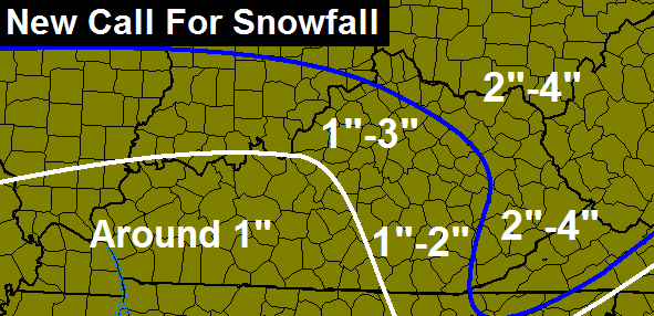
– I will put out a final call later tonight. There is still the chance for this system to ramp up into a little bit more before all is said and done.
– Temps will drop into the high single digits and low teens by Friday morning. Wind chills Thursday night and Friday will drop well below zero.
The storm system that moves in Sunday into Monday is likely to put snow on the ground and it could be several inches. The GFS continues to trend in that direction…

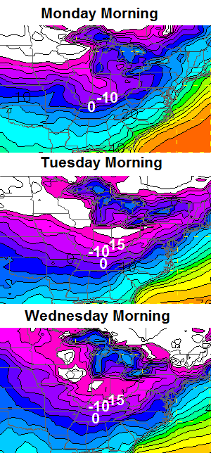
The blast of arctic air coming behind this continues to look BRUTAL. Check the numbers from the GFS for lows…
Wicked is the word! I will update things later. Take care.

When was the last time Lex had 3 or more consecutive below zero nights? And the most?
I think 93 was.
1996 had 3 straight days below zero. 1989 had four in a row two times within a ten day span. So, eight out of ten days were below zero. Before that you have to go back to 1899–the year Florida had a below zero temp, the Mississippi River froze over in New Orleans, and frost was reported in Cuba.
1-3 for starters, we’ll take it!
Cool! CB sees the cold air hitting about the same time as the precipitation. If the event hits as CB articulated, it will have a good shot to surprise. It should also mean a decent chance for early next week and double longjohn weather. Two hats too.
Ugh, my area moved from 1-3″ to around 1″. That’s OK because I’ll take it if the Sunday system gives us the mother lode!
I’m not greedy I will take 1 to 2 inches here in Louisville.
Sunday night is win I want some over achieve ment action.
I really hate the rain to snow events
Awesome Chris, I’m here in johnson county pulling for 4 inches Thursday night, if we do get that much. I’ll really be getting down with the big snow dance then pulling for a foot of the white stuff followed by by 5 to 10 below zero for a couple of days.
Around what time will the bad stuff start in eastern Kentucky? I need to make a quick trip to Prestonsburg tomorrow!
I keep reading “chance to ramp up” but the second map just lowered Madison from 1-3 to 1-2 inches. If that’s “ramping up”, I’d rather not have any more of it.
This weather is 12+ hours away and still no mention of an Alert Mode or Threat Mode. Hmm.
Nice shot posted on CB’s Twitter if you missed it; first sunrise of 2014 in Woodford County.
http://twitter.com/billcaine/status/418380690195898368/photo/1
Perhaps he should have added: or it might ramp down 😉
It is CB vs everybody else, since not seeing a similar forecast anywhere else. Yet at least.
Check the new NWS forecast out. 😉
Ahead of the curve as usual 🙂
NWS has a mostly rain event for Louisville on Sunday with a change to light snow on Sunday night. They are going with the warmer solution from the Euro and UKMET while they do acknowledge that the GFS gives us more snow than rain. Will be interesting to see how this plays out but lets get through tomorrow first. Here’s hoping for a couple of over achievers.
Oh my aching bones in this extreme cold. When you are young its fun and exciting as you get older not so much
Amen! I was born in the 50’s went through the snows of the 70’s and now every bone, joint and muscle in my body hurts and some places that I didn’t know I had hurts! On another point, a 3 inch snowfall when I was growing up didn’t stop anything as far as watches, warnings and so forth. If it was school week you just got up and go. I don’t understand calling off school for such little amount of snow. I went to a private school and it didn’t matter what they called for or how much they said we would get, you were expected to be there.
New follower from Knoxville, TN but formerly from Leslie County. Rarely any snowfall for Knoxville. The Plateau and Smoky Mointains get snow more often here especially the higher elevations in the mountains but Knoxville usually misses out on any measurable precipitation. Our meteorologists, especially at WBIR, really work overtime if there is any chance of snow regardless of how slight. Nice to see so many people excited about snow. If this were the forecast for Knoxville, we would be in full panic mode. We can only dream!
a whole lot of good people in leslie county…glad to have you on board
So, any chance this will hit prior to “go to school” time?
If we aren’t going to have snow/cold I’d rather have a day like today than cloudy and rainy. 47 and sunny. Loving it!
This one comes down to Chris vs. the NWS. Not even a special weather statement now for most of Central KY. Not sure why the discrepancy less than 24 hours out.
Will the Saturday warm-up cut down on snow amounts for Sunday or will it just come crashing in as all snow? Odd that we go from 40s to teens to 40s to single digits. Sounds a little too messy and unpredictable to be a sure bet for anything. Hope the cold wins out for a Monday day out of school!
WPC Operational Model showing 70-80% chance for snow >1″ but <2" for 00Z Fri down to around Berea and into eastern Mercer County. Thinking the advisory may expand down into these areas for their FA.
Still thinking a general 1-2" snow for the Lex metro.
These numbers, or probabilities, for the 00Z Fri timeframe have increased around 10% since the last update. Will keep an eye on trends as this looks to be picking up information about the storm.
Does anyone know how often this updates?
There was some talk a few days back about January 1994 should we get some snow cover prior to the Sunday system — is that still a possibility? I’ll take the snow, but they can keep the -20F up in Canada where it belongs…. Thanks Chris for giving us winter bugs an outlet, by the way.
WWA from LMK has been expanded down to include Garrard and Madison counties, as well as the LEX Metro area now.
CKY is always a border area though. Not more center of the flow. Uncanny but true. Systems go all around CKY unless ice. Trippy and wild at the same time.
Damm River…LOL
It sometimes saves us from bad ice storms sometimes that throttle Lexington (3 in the past 27 years I have been here), so take the good with the bad 🙂
Bring it on. I could use a couple more days of break before getting back to school.
i was wondering if the european model has backed off a little with the extreme solution for the storm or the artctic invasion or both….chris b. hasn’t mentioned it in the last couple of posts not that above zero with biting windchills and 3 or 4 inches on the ground isn’t extreme for this region.
Well he has been showing more GFS and the brutal numbers it is giving. And he has mentioned the GFS coming around to the Euro. I was wondering what you were wondering but I thought maybe he was using the GFS to sort of highlight how it has changed from not showing this to actually showing it in a stronger and stronger way.
I am wondering how these storms pan out. If we get enough snow on the ground that should pull temps down. It should also help produce colder temperatures Monday and Tuesday and I am wondering if that helps us up the snow ratio if a storm does hit. And then how would that effect the later in the week temperatures and the next storm. Seems like there is at least a better potential with this compared to some storms and cold in recent years.
Nice shots of wintery precip coming our way for the next few days. Most all storms shift to the north/west when they arrive. So look for cold rain for some out of both of the next to systems. Other side of the river will once again win out. Going to get really cold next week. Hope we can get a decent snow pack Thur/Fri to keep temps down for the next system. Thanks for the update Chris.
If there is rain with the next system, forget the sub zero temps for most.
Need the snow pack to get the real cold. We are so overdue. Looking at WunderMap Interactive weather and they are forecasting 3-5 inchs for the Etown area late next week. Snow/Freezing rain for much of the region into next weekend. The fun and games are just starting.
Not sure why folks put so much stock in the NWS. That’s why I follow CB. Last storm through here in Charleston we had no WWA and Chris had us in the 2-4 inch range. Woke up the next morning to 6 plus inches of snow and multiple accidents. The NWS finally put out a warning at about 5in the morning after the snow was falling. Keep up the great job CB.
I don’t think folks are using the NWS or other met references to imply CB might be wrong. CB tends to be ahead of the curve for the forecasts, but we just tend to see it earlier here.
Gives a sense of catch-up by the other mets 🙂
NWS seems to Nowcast winter storms, maybe a smarter approach with so many model failures in this area!
Where is the Like button? You are absolutely correct Bubba. CB is always days ahead of the pack.
Beggers can’t be choosers. I hope for 2 here in Lex. Let’s all be jealous of my friends and family in MA getting 12-18 inches from this system.
Don’t be. They are also getting much colder air as well. Not a fan of mega cold air and wind combined. I would cry when out in it, but my tear ducts freeze.
Right on when it comes to the NWS if it is Govt run there is noway I would put any confidence in it as an agency
Look at where the advisories are posted. Seems like the KY river is the dividing line again!
Darn topography! 😉
Hey–I’m 3 miles West of the river–I kind of like the topography! 🙂
so with this 1-3″……how much does the Clay’s Ferry area expect? I mean I want to get excited for snow. but I have a hard time doing that with this dang river effect. with that said… Chris, I appreciate all the hard work you put into this blog. I seriously enjoy reading it every day. us weather weenies would be lost without ya.
Safe bet is 1-2″, or 1.5 inches.
Looks like the fence will set up shot here on Sunday…Going to be a wet one for most with a little back side snow. Just what we need..
MEH…
“SHOP”
That would likely kill the sub zero temps. I thought the original outlook was around freezing or below for highs going into Sunday with snow cover and then the next system hits. Not a fan of super cold, so okay with me regardless.
will be interesting to see if the 00z models, hopefully they don’t throw any curve balls, unless of course they want to bring us more snow in the Ohio Valley!
Some of the models showing a very healthy snow for much of KY for the Sunday event! Let’s hope!
Bring on a moster snowstorm followed by below zero temperatures so it stays with us a few days. I have not seen one of those in a lone time.
I don’t think the snow tommorrow will be much to get excited about, maybe 1 inch tops for most places, I’ve noticed in Missouri tonight they are expecting 2-4 inches that way, maybe this system will surprise??
I hope we get this snow in southeast ky …. I just hate a forecast that starts out as rain my guess is we had better hope for the upslope because it will fall as mostly rain till dark tomorrow night
Well, I hope everyone is ready for the blowtorch that’s coming 🙂
Pun intended
I’m ready–I’m wondering if we will hit 57 at all in January–much less for an average high!
Do you have any predictions about the timing of this even for NE Ky? I am worried that we will get to school and then the snow will start to fall and then we will have to worry about getting the children back home in a hurry.
I think there will be a lot that go half a day
That’s the worst. It’s so hard to bug out in the afternoon with so many parents working and we have to find someone to send the kids home to. It’s very stressful.
I was wondering that myself. Last time it snowed during school morning rush was a mess.
Chris is the eur. still showing way below zero temps. and snow early next week?