Good Wednesday evening, gang. A Winter Weather Advisory is now out for much of central and eastern Kentucky Thursday into Thursday evening. A quick-hitting snowfall is in the works for Thursday as low pressure scoots by to our south and east.
Here’s a look at the Advisory…
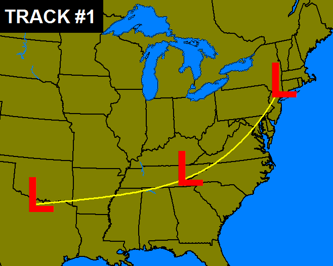
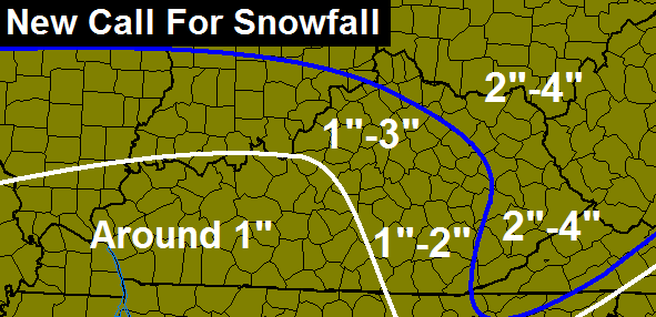
A general 1″-3″ will be possible across the region. Locally higher amounts will be possible in the far north and southeast. The snow comes in two waves. The first will be behind the area of low pressure from mid-morning into early afternoon. This works eastward across the state during this time.
STRONG northwesterly winds will blow up widespread snow showers and squalls. These can really create travel issues and put down decent snows during the afternoon and evening. Gusts of 35mph will be possible and that will blow around whatever snow falls where you live.
As arctic cold moves in during the afternoon and evening and this will take our temps toward the high single digits and low teens by Friday morning. Throw in the gusty winds and you may get this…
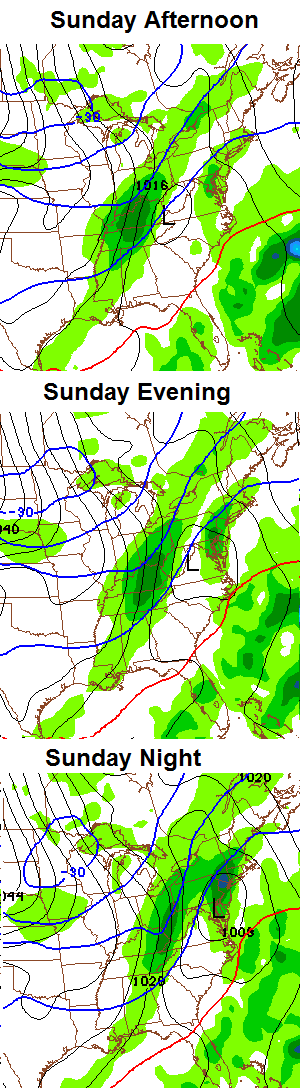
 All eyes continue to be on the extreme setup from Sunday into early next week. A major arctic attack is likely to send our temps below zero for a day or two. This surge of bitterly cold air is likely to be accompanied by accumulating snows. The GFS continues to place most of the state in the area of significant snow…
Stay tuned! Enjoy the evening and take care.

Well Chris you had west liberty in the 2 to 4 now you have us in the 1 to 3 now what is up with that….lol
it appears you have it backwards, he had you in the 1″-3″ and now has you in the 2″-4″
No at 6 he had us 1to3 on the blog he has us 2to4 I think
Bengals vs. San Diego should be fun to watch!
Go Steelers!
Bengals vs Steelers would had been much better. That idiot kicker from KC should had made that field goal. And then the refs not calling a penalty on SD for having 7 guys lined up on one side of the ball….Geesh…But, I guess the Steelers only have themselves to blame really. Blew a couple of games late….Go SNOW….I am sure the Bungles will find a way to mess things up as usual.
Winter, snow, cold, windy, wind chill, Brrr, negative, frostbite, ouch, excited, yay, yolo! Bring it all on!
🙂
lookin’ good-let the snow begin!
*Snorts in disgust* Hopkinsville! Nuff said.
The Swath monster has been sited to the northwest of Kentucky and headed our way.
Have noticed a little moisture breaking out south west of KY along the Mississippi River, If this could merge with the northern stuff coming in a decent thumping snow could happen in KY???
I know I’m wishing 😉
Local competitor saying 0.2 for most of jkl coverage area . Local higher amounts north. And se ky in higher terains above 2000 thurs into friday.
Looks to be cold next week. Everyone stay warm , try keep water pipes from busting
Probably correct
Winter+Snow=Magic
Very well said!
folks this tomm will be rain, to snow as it bout over for most of S/EAST/SE KY sorry even central. be dark before it cold enough. sorry but don’t get to excited bout tomm snow. need to hope something happensd SUN/MON as tomm is moving way to fast.
Typical rolo….nonsense
Rolo is correct in that if this does not pan out, it would probably impede the results of the next system. They both seem mostly mutually inclusive in regards to impact.
Oh really…I thought rolo gave a good explanation of probably what will happen,,I guess opinions are like donkey’s..Everybody has one..
todd if we could got these 2 together we had BINGO!!!
As far as the models go now what type of snow are we looking at for Sunday to Monday? Moderate to heavy or light to moderate?
Since Boyle County isn’t in a snow advisory are we going to be getting rain or mixed precipitation?
Scott co. Schools expecting it to be bad tomorrow. Already canceling school.
Looks like Mother Nature has a date for the New Year, and his name is Old Man Winter. We just might get that snow everyone has been waiting so many painful winters for. Too bad we will have to deal with some bone chilling temps behind it.
http://wxcaster.com/gis-gfs-snow-overlays2.php3?STATIONID=LVX
That looks like the 93 and 96 events. Not seeing that happen now, but I am blind to the trend.
This is the Thursday and Sunday events combined, correct?
Yes.
I’ve seen some decent snow in recent years but the bitter cold has stayed away. I think this might be the longest period on record without a -10 temp in Central Kentucky. Last one was 1996 and that came without a deep snowpack–maybe 3 inches or so. The arctic outbreaks I remember are January of 1985, December of 1989, January of 1994, and February of 1996. March of 1996 also featured a day with highs in the teens and a big snowfall.
I remember that one since had to drive from Richmond to Paintsville to pick my mom up the next day. There was a lot more than 3″ and could not see the road or boundaries the entire journey. I had to do it so my mom could watch or newborn son for a few weeks. Wifey went back to work and still was looking for a day nanny.
Quest mini van has real good traction control 🙂
To Todd’s point, nowcast (radar) showing merging sweet spot in Northern KY/Southern Indiana?
Aleady down to 34 in Frankfort, maybe a surprise phasing event coming in, Chris might have a more educated update on this later hopefully!
The National Weather Service in Louisville, KY is forecasting a high for next Tuesday, the 7th, of 12F. We will either need a decent snow pack, a blustery northwest wind or a combination of the two. It is easier to adjust forecasted temps up or down, and save face with the general public than it is to whip snow totals back and forth. Just my thought, and as CB says; “Stay tuned.”
Brian Goode WAVE TV GFS has weaker low. Goes more east. Euro has stronger low. Forces it more north. Still need time to gauge low strength. The new snowpack tmrw likely will give the GFS credit. Depends how much melts Saturday and Sunday.
the GFS has Louisville receiving 7.2 inches sunday through Monday.
I guess we need a good weak low.
If the current highs are correct for Saturday and Sunday, the snow will mostly melt. This is why non wind chill negatives seem dubious right now.
I’m seeing some snow and cold chances in this pattern unlike much we’ve had in recent years. Chris has been talking “extremes” and looks like we are getting ready to see just that.
remember its Kentucky it’s the little engine that could.
I do not take anything for granted.
00Z NAM is running. It is out to hour 21. Here is the 1/2/14 15 UTC panel (if it posts).
http://mag.ncep.noaa.gov/Image.php?image=data%2Fnam%2F00%2Fnam_namer_015_850_temp_mslp_precip.gif&model=nam&area=namer&storm=&cycle=00¶m=850_temp_mslp_precip&fhr=015&group=Model+Guidance&imageSize=M&scrollx=0&scrolly=0
As a school teacher I am worried about those wind chill temps for Friday morning. I hate to think about small children waiting for a bus in that kind of cold. I hope that those in charge make good decisions for the welfare of the children.
will say the SUN/MONDAY storm is looking better and better.
4 -10 inches statewide with low end SOUTH more as u ride northward and NE.
still don’t see more than 1-2 for some from Madison co north and east as rain going be main precip for S/SE KY unless ur in BELL,LETCHER areas ontop them MTS.
u notice QUICK hitting band of snow LIKELY behind this as it comes, folks that means ISOLATED areas MIGHT see a quick inch or so. that from a CB tweet the quick hitting, those that been round knows that means u better be lottery ticket luck to get anything much.
The forecasted low temperature in my area for tonight was 32 and it is already down to 26. I wonder if the overall temperature will be lower for tomorrow or if the temperature will balance out once the warm air comes in from the south? Be interesting to track.
25 now and still dropping. This is getting very interesting.
Will warm up as the moisture first starts.
I don’t want to be the gloom and doom guy, but isn’t it reasonable to say that, while the cold is headed this way, the models really seem to be backing off the snow? Right now the GFS is the only system showing snow on Sunday (for Louisville anyway) while the Euro and the Canadian are showing mostly rain. The NWS in Louisville is going with all rain.
The cold, as I said, is still there, but after a predicted high of 12 on Tuesday in Louisville, the next system warms us up and brings rain according to the models a week from today. I find it fustrating, to say the least, that such arctic air could be wasted, but isn’t the problem that just don’t have a negative NAO? With no block, the cold moves in and out and the storms can cut further north.
The NAM also shows snow, so apologies for that, but it still seems like the GFS NAM solution is being discounted by Louisville NWS.
Still plenty of time for the models to sort it all out. Not sure why the NWS would totally discount two of the four major models when making a forecast, but I’m sure if they continue to show snow they will be changing their tune soon enough.
if you want it to snow in Kentucky we have to earn it.
72 hours out I like the GFS
the euro and Canadian modelS have been doing a good job this year sniffing out moisture from 5 to 7 days out.
which means there’s going to be precipitation in the area.
Im looking at the NWS Louisville forecast. They have ‘snow likely’ with a low of 16 for Sunday night. From the sources I have seen,
I’ve been under the impression this was an overnight event…did that change?
When I type in my zip code, which is for north east Jefferson County, it shows a high of 42 with rain likely on Sunday with a chance of snow Sunday night.
maybe they have 7 different Mets in that office with different forecast.lol
I swear I’ve seen like 3 different forecasts for Sunday lol
Yep, but they all say some snow and cold are expected. The numbers are what’s different. One standout difference for tomorrow is 18 has made no mention of the key secondary snow later Thursday. Only the mid day.
Now they added early evening. CB mentioned the later snow is the key.
Stand corrected. 18 says less than an inch for all but northern Kentucky and essentially discount the evening snow. Say the mix will kill accumulation.
I rarely recall where 18 agrees with 27/56. I rarely watch 36 news. Not a particular reason other than habit.
It’s never a cut and dry forecast with winter storms in KY, players on board are always Dry slots, Verga, warm air advection, weakening low pressure!
Boston is forecast to get 12-18, I’m sure they will get 20 plus!
Go Figure 🙁
Chris’ map had Magoffin County in 2-4″ earlier…WYMT barely had us in the 1 inch category at 11 PM…. 🙁
Pretty big hit according to the GFS on sunday for pretty much all of Ky….Trouble is we in the bulls eye to early..So no doubt it will change..
The Euro forecasted the Sunday event days ago. I believe it’s better at long range. It’s not on board now but the GFS and NAM have picked it up as it gets closer.