Good Thursday, folks. Today starts a crazy period of winter weather here in the bluegrass state and for much of the country. The pattern is going to the extreme and it starts with a light snow maker and arctic cold winds blowing out there today.
Talk about a changeable day… today is so much of one that I have decided to break it up for you. Here we go…
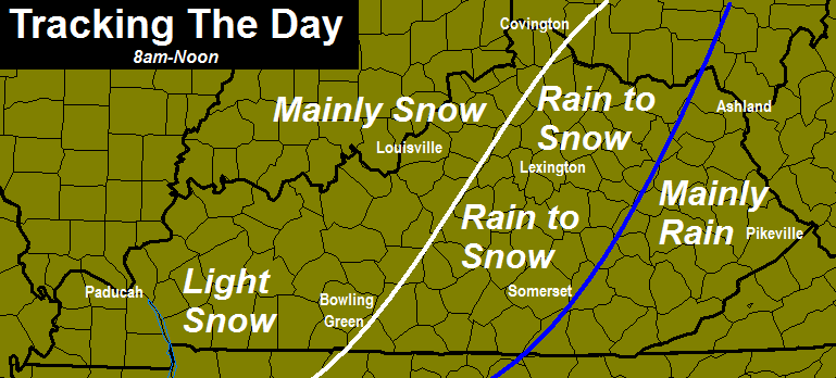 Low pressure during this time is tracking along the Tennessee border and has a band of light to moderate snow wrapping in behind it. That will scoot quickly eastward into the afternoon…

That band will work across eastern Kentucky and will give way to widespread snow showers and squalls that kick in on the cyclonic flow. You won’t see these coming… they will develop quickly right on top of us. Throw in an upper level disturbance diving in with strong cold air advection and these squalls can pack a punch into the evening…

It’s during the afternoon and evening that travel is likely to be impacted most. Winds gusting to 35mph will blow the snow around and the squalls will reduce visibilities to under a half mile at times. How much snow are we talking? I put out a last call for snowfall on WKYT at 11 and that’s the one of record. Many areas will pick up an inch or two with locally higher amounts possible. Again… much of that won’t happen until later in the day and into the evening hours. This is NOT a big storm and you won’t be able to make any snowmen. 🙂
Temps will start the day above freezing for most areas and then tank from west to east. A quick 10-15 degree drop will take place in just a few hours this afternoon and early evening. Most locations are in the teens this evening and will drop toward the high single digits and low teens by Friday morning. Factor in the gusty winds and wind chill numbers will drop below 0 at times.
From here… all eyes are on the big daddy blast of arctic air coming early next week. The arctic front will work into the state late Saturday night into early Sunday. I expect a wave of low pressure to develop along this boundary as it slides through. The GFS continues to show the setup that matches my thoughts…
I
That has the potential to put down several inches of snow across the region into Sunday night. If we can get just a couple inches out of that… look out. Temps early next week will approach levels we have not seen around here in years. The GFS lows…

The GFS actually keeps much of the state below zero for near 48 straight hours. Again… for that to happen, you will need snow on the ground. Without snow on the ground… temps will still head toward 0 or slightly below.
Oh… could another system deliver snow and ice to follow up the arctic blast by the end of next week? It’s a crazy pattern.
I have some tracking toys for you guys…

Current temperatures

I-75 @ Winchester Road
Lexington

I-75 @ Iron Works Pike
Lexington

I-75 @ Clays Ferry Bridge South
Between Lexington and Richmond

US 60 @ US 127
Frankfort

US 127 @ Frankfort
Frankfort

I-75 at MP 36
London

View of Downtown
Harlan

I-75 at MP 36
London
I-75 at MP 23
Corbin

I-71/I-75 at Buttermilk Pike
Near Covington

I-64 @ 3rd St. Exit
Louisville

Downtown Louisville @ 2nd & Broadway
Louisville

I will have updates later today. Have a good one and take care.

Thank you for the break down on the snow. Bring on the snow!!
I am with you Lisa I hope it snows hard in Berea. The kids don’t go back to school until Monday but they are still looking forward to snow…
Thank you Chris. Always the BEST.
Wow….I know this was not suppose to be a major snow storm by any means of the way, but when you put out a WWA for much of the region and you wake up to cold rain showers and see a huge dry slot between the two shields of precip it is rather disappointing. Most of Ky will only see a dusting at most (except extreme NKY). Should have stuck to my own thoughts and went with the trends of KY….The fence….Cold rain to little snow….Dry slots….Welcome to KY winters. Only get snow out of freak storms when no one is prepared. Not getting my hopes up anymore for snow here in Louisville area. Going back to the IBIWISI motto. Thanks Chris for you thoughts wish they would have developed like you suggested. It must get real frustrating being a met in our region of the world. Have a great day.
CB said last night as the map says now, it would mainly be rain for most east and then a quick change to snow as it moves west. Given we have not had a trend buster in five years (our last big clipper), it seems you should have never drifted from IBLWISI 😉
Was hoping the Sunday system would have a little more pep to it, but that looks like a few incher at best for us. Again, you need to be somewhere else other than here to get the main stuff. Ain’t it wild that even with heavier arctic influence it makes no difference for us? Warm air has it’s way some how.
I don’t’ see anything that wasn’t expected.
Not saying CB was incorrect…Just did not see NWS reasoning for WWA…I do snow removal. Having a ton of salt on truck for a few days without spreading is annoying. I expected a little more here in Lou. along the river. You guys in the South never had a chance.
Chris gets on them all the time for not issueing one when it is going to impact rush hour and from the reports lots of roads closed so you cant have it both ways
You are soooooo correct!!!!
Im glad Micah trimmed the totals a coating is more likely for the south then 2 inches but 2 ft would make me happier
The current radar is actually quite funny. Snow to the north, east, and west and a nice big dome of rain over Central KY.
Roads are solid ice, wrecks everywhere. Hal rogers parkway shut down.
thanks for the info
Heard 20 wrecks since 5:30 on scanner.
So thankful this is mostly a rain event Dislike big snow and I surely dread the extreme cold weather. I pray for older and sick during extreme weather. Have a great day folks and don’t forget your umbrella 🙂
The event is just getting started and for some it won’t be mostly a rain event. Wait till this evening 😉
It’s snowing at my house no umbrella needed! HA!
Most are saying dusting to less than an inch for all but north KY, so will be interesting to see what happens. For Monday based on trend and average of models from a few days ago, it looked then like the highest chance was an ankle biter and temps ranging for the state with lows near 0 to -4. Looks like that still has a shot. I would go though the usual fence blah blah, but I am as tired of typing as you are of reading it. Too obvious.
What little we may today get will be dangerous in spots, so watch out for the drivers around you!
CB’s forecast for today still seems closer to correct than the other mets, but I think they are banking heavier on trend. Kind of like, the model always say 2″ but we usually get 1″…. 1″ it is then.
Can we all now agree that the weather models are absolutely worthless during winter? The only difference today was instead of a cold rain, it’s been a cool rain.
To anyone traveling in Knott/Perry county this am the road is much more than wet, black ice everywhere,? freezing rain.
I am taking back what I said in previous post. Louisville won’t even get a dusting out of this system. All rain with cold air moving in after rain moves out. The Sun./Mon. storm will be a thumper for those North of the Ohio River. Ky will have a cold rain before it all moves out and we have the cold air to deal with. At least with no snow on the ground it won’t get below zero. But heck anything below 10 degress is freaking cold.
Looks like freezing rain for the morning commute and snow for the evening commute. Be careful out there everyone.
Currently 36 in Lawrenceburg, KY with drizzle.
cold rain on Sunday.
that’s my forecast
does anybody want to bet against it.
You are correct sir. No way I would vote against that. I said 2 days ago this would be a no show as well as Sun-Mon system.
NO…..You will win…
Today isn’t even a COLD RAIN, but a COOL RAIN instead. Winter’s over before it ever started, folks.
Anyone know how much Paducah has received? With those temps and what looked like a moderate band of snow on radar I’m wondering what it amounted to.
Temps right on backside. Ground covered here in WKY.
The 06z GFS looks like from 6-8″ for most of KY. Is that a total of today’s snow and Sunday’s??
I am sure it is not todays precip. All that is falling here in Lou is cold rain. Sunday/Monday will be more of the same. Rain for Ky. SNOW North of the Ohio River. Kentucky trends for past 15 – 20 years.
Yes, it is from now through 84 hours.
Sorry 120 hours.
from what I’ve read. the GFS was betting on a snow pack before Sunday.
do not be surprised if that models B comes warmer as we progress towards the weekend.
ok, I’ve been basking in the sun in the Bahamas the past 10 days and come back and read that January is going to arctic zone. Then I look at my area for next week and only see 2 days with extreme temps (Mon and Tue) … then warms back up ….. next Thu high of 51, Fri high of 53, and Sat high of 57 ….. I’ve asked this before and never get a straight answer, just snide comments — why is there such a big difference ??
you get your forecast from 2 different places
It is do to the fact that geographically Kentucky sits pretty much dead center of the Eastern Half of the US. Always between the Cold air dropping in and the warm air moving up out of the Gulf. It has been a general rule of thumb that the warm air always wins out over the cold. So when Ky gets in on a Artic blast it never hangs around very long. My case in point will be The following seven days of weather. Cold with chances of snow that will be rain events…COLD AND DRY….WARM back up with a chance of snow that will be rain. Get it…Not being snide….Just trying to prove that the trends of Ky weather in Winter have been just that for the past 15-20 years.
thank you …. I appreciate the response …. really the weather here is to take it one day at a time!!
Rain then snow flurries wow.
Wow, wasn’t expecting an ice event this morning severe enough to shut down roads and cause hundreds of accidents.. We have been having some very cold nights lately.. guess the ground temps are pretty cold and RAIN before daybreak was sure to freeze on contact.
The accumulating snow’s wont hit to later today with snow squalls/ snow showers. The evening commute for some will get nasty not everyone will get the squalls but the ones that do it will come down very intensely and will stick!! Temps are going to tank rapidly in a short order. Indianapolis is already down to 18 degrees and falling. Ripley county in Indiana has been placed upgraded to a Winter Storm Warning. With heavier snow squalls developing later on also look for snow covered roads and possible flash freeze developing. I know the winds will be gusty and that helps to dry the pavement up but with the little rain we already got with temps falling rapidly and snow squalls ramping up we all will still have wet roadways that will freeze up in a quick hurry.
Black ice throughout Johnson County. Roads are slick with numerous accidents. I think this has sneaked up on everybody.
After 9 years, experience has taught me to:
1. Doubt the models.
2. Fear the trend.
3. Respect and thank Chris for his efforts and expertise.
4. Enjoy the blog.
1/4 inch and counting…
MIKE….Well said……#3 especially….
Nothing to see here in Middlesboro. Temp has gone up 2 degrees to 38 in the past 30 minutes. I expect 33+ degrees until most of the moisture is out. Good luck to the rest of you for a dusting though. 😉
Neat tool for the Louisville people..Bottom shows snow..
http://wxmaps.org/pix/sdfgfs.png
http://wxmaps.org/pix/meteograms.html
I TOLD U, there was no mention of a LONG TERM RaAIN by aanybody but me.. there be as I posted last nite the lotto factor, meaning if u get under one those isolated snow shoers u might pick up a inch tonite.
It looks to me like CB’s tracking the day posts are pretty much going to hit the nail on the head, so you weren’t the only one mentioning rain.
On a side note, those red squiggly lines underneath half of your words are misspelled words. You can right click on them to change them to correct spellings.
Keep patting yourself on the back, Rolo. It gets you nowhere.
I’ll pat him on the back because he has been and will be right. 😉
He does nothing but flip-flop until he is right. Anyone has a 50/50 chance of getting something right when they do that.
TRUE DAT….Rolo can mispell all he wants…His forecast usually correct.
Giving the fact that most of the state isn’t suppose to see any snow until around noon-on.. CB’s 1-3 inches isn’t necessarily blown and it’s never surprising to watch upslope happen. We will see what happens with the showers and squalls. They can be very powerful.
Look at the radar, the moisture is drying up, there’s just not enough there for more than a flake or two. These back-end snows amount to absolutely nothing……and you can take that to the bank.
Calm down snow squalls and snow showers will be developing it’ll start looking wintery shortly.
no patting on back, 4 out 10 around state WILL see snow on ground. it will be ISOLATED as I said. the main precip going be out state, but the SCATTERED SHOWER stuff will indeed be around tonite. so the forcast we go by will technically be hit.
im not ragging on my boy when I make my post. I have learn not to BELIEVE any modelsetc no more when we are in winter.
BLACK ICE has ALREADY caused more trouble in MANCHESTER and suurounding areas than any dusting of snow will ever do.
troy this system not a warm air deal, it will snow at 34 degrees. but as far as laying then yea u need 32 below.
Evidently nobody saw the ice coming this morning! Multiple accidents and road closings in eastern Ky!
So much for ‘Blowtorch’ mania. Cold through the second week of January.
By the way, NWS Hazards Report for days 3-7 paints a blob of heavy snow for much of Kentucky for the January 4-5 time frame.
If that verifies (remember, Kentucky knows how to jinx these things), those expected arctic temperatures may go colder than what’s being forecast.
Double-digit sub zero readings possible???
Finally. Snowflakes mixing in at 10:00am in Valley Station.
Still raining and 34 here in Lawrenceburg, KY as of 10 a.m.. Freezing line looks to be at Interetate 65 as of now.
I swear some of you people are so negative ALL the time…it’s annoying
Ironic comment #1: “Negative people really annoy me.”
I agree with him. All the negativity is very annoying.
Check out the temperatures crashing on the mesonet.
Same ol same ol…cold air arriving too late for moisture…at least for Berea and this area
this next system more and more has a OLD SCHOOL LOOK to it, very exciting times ahead in the weather..
FLOYD exactly, NO MENTION ON ANY OF THE STATIONS OF THE ICE this morning in EASTERN/SE KY..
In my area of Louisville, rain changed to snow around 10 AM. Unfortunately though, it’s been a bust. Nothing is accumulating and the precipitation shield is moving through rather quickly. Any forecast in Louisville that includes rain changing to snow and then accumulating is tricky because the warm air never wants to get dislodged. That’s why I’m not optimistic at all about Sunday. It’s quite laughable, but it’s so Louisville to have a forecast for heavy rain on Sunday and a high on Monday of 15. That’s life in this area of the country. I might feel more optimistic if it weren’t the GFS that was in our corner, though!!!
Dome spotted: http://i.imgur.com/uVPJrYw.png
WARM AIR ADVECTION our old snow dome friend is in Central KY for a visit of snow chance eating!
If Frankfort gets a dusting today I will be surprised!
The snow squall upslope never does much in my part of the world, good luck east KY!
It has been very bad in Letcher Co. This morning. Wrecks everywhere, many roads were closed . Temps are on the rise so hopefully this will get better. Have a safe day!
The 12z runs of the NAM and GFS look very promising for this weekend
Now THIS is the blog I have grown to love! Drama, hubris, elation, deflation, positive, negative and everything in between 🙂
This blog sometimes can have a Jerry Springer vibe and that’s alright. Keepem’ commin’ 🙂
hubris. Isn’t that the Middle Eastern stuff you eat with pita bread!? lol
that’s Humus 😉
Humis to me tastes nasty. Bleh.
Oh, well then you’d love the angry texts I’ve gotten this morning “WTF no mention of ice or freezing rain”…”why are the roads are all %$# up?!…”, “changeover wasn’t ’till this afternoon!”, etc, etc. Not all of these people follow WKYT or this blog, so obviously the other stations didn’t mention it either.
I pray no one is seriously injured in all of these accidents.
Huge bust in Louisville. All Mets were saying most of our snow would be in the morning. I bet the Sunday system will be all rain.
This is for all the crying about no snow and the “dome” and why Kentucky sits on the fence. Well, it is because of these factors that Kentucky does every now and then get those big snows. Most on here aren’t truly old enough to have knowledge of the 60’s and 70’s winters, there were some cold and some not, then the 80’s and we had a bad 1984 and a 3 foot snow in April 1987. The 90’s saw the storm of the century and the dusting of 1998. In the 2000’s, we had a couple of decent winters with some good snows, in 2010 we had a foot of snow before Christmas and no electricity for 7 days. Now these are the events you remember but not the warmer winters, so you see because Kentucky sits where it sits, we get the extreme events, not the bad winters every year and you know what, I like that. Just wait, when it snows 1-2 feet, and it will at some point, maybe then you will gain enough experience points to enjoy Kentucky’s weather. Chris I enjoy reading you blog and have for years, I have also enjoyed the comments section, but some on here just don’t get it.
Don’t be too hard on people for complaining on here. Kentucky winters are psychologically hard to take, because most of the time we don’t have any snow to anticipate, prepare for, or deal with. If we did get regular snows, the monotony of winter would be broken up by preparing for it, dealing with it, playing in it, etc…
Yes we do get the occasional snow. But it is VERY occasional, and for most of the time in a KY winter there is very little to break up the monotony of either dry cold air or cold, cold rain. People gripe because they don’t know what else to do. Gotta keep your sanity somehow.
35 and raining in Versailles. It’s January 2nd and I’m done with winter. I want spring. Bryant, I want your blowtorch. Give me 55 in January and 65 in February and I will be happy. I would rather be guaranteed no snow than to play the model game all winter & get what we have out there right now.
I have been around that long and that is the point. We went from a few big events every few years since the 60s to several ankle biters every year (last two years not even those for some of us).
We in CKY went from an average of at least every two years at least for one big event, to nothing beyond a few clippers for sixteen years. Fairly significant gap (800%).
Cinncinatti under a winter storm warning for 3-5 inches of snow with blowing and drifting and temps in the single numbers by morning, maybe I will drive 80 miles north to see some real winter?
Frankfort rain and 35 🙁
Am I missing something that in spite of all the model talk, CB has yet to go into a threat mode discussion?
I look for him to go into threat mode tomorrow night or Saturday for the Sunday system if the models continue to trend toward snow. Really wasn’t a point to go into threat mode with today’s system since it was never forecasted to be above advisory levels for anyone.
These are difficult times for us snow lovers. Models are rarely correct, unless they pick up on warming trends it seems. Remember, gang, the trend is our friend. That’s why I’m ready to call for a statewide rain on Sunday followed by a 2-3 days of below normal temps. Nowhere near record cold, just the usual quick shot of cold air, followed by moderation. Sorry to burst the balloon, but this the current idea on some of the other blogs I follow. Yes, my blowtorch may have been dampened, but let’s not forget we have the rest of the month, and I’m feeling even better about trace snow amounts for Lexington for the entire month of January.
Happy New Year guys….
Just so painful to watch the precipitation start to dry up right as the cold air arrives. It’s bad when you can’t even get an inch or 2 of the white stuff. The only thing turning white around here is my hair. I’m sure Sunday will be the same. Please prove me wrong Mother Nature. It’s always wait til next time and when it gets here, squat as usual.
Bowling Green has had heavy snow with a good covering on the ground, If I remember correctly that area was suppose to be in the zone of least snow, now they are getting more than north central KY,
Crazy KY Weather!
sunday storm must not be looking too impressive. There hasn’t even been mention of winter storm threat mode.
Changeover has begun in Lexington. Still to warm to stick, though.
enjoy your 45 minutes of fame.
Great writeup from Louisville regarding the correlation of past sub zero weather and snowpack. It can get below zero with little or no snow cover, but not to a crazy extent:
http://www.crh.noaa.gov/images/lmk/pdf/Does_There_Need_to_be_a_snowpack.pdf
We have about 2″ of snow on the ground here in Boone County. It turned over from rain to snow around 5am or so. The wind is really ramping up now, starting to blow the snow around. Temp already down to 28 degrees.
Snow falling on Lawrenceburg but not sticking. It is almost comical to watch the temps crash just as the precip moves out.
Yep same in frankfort, the snow has started but back edge of good precip entering Shelby co.! Might get a deck duster??
Doubt we’ll even see a deck duster. Snow trying to accumulate on my deck. Sitting at 34 degrees.
It’s over folks, Wormer dropped the Big One.
BigPoppaSnow ( Now it’s going to get cold & not even rain)
still 35 deg and rain here at 12:30, Hoping we will get the change over before the moisture is all gone!
GFS is on crack? Judge for yourself folks……not a chance in you know where, will this map play out…. http://wxcaster4.com/gfs/CONUS2_GFS0P5_SFC_ACCUM-SNOW_120HR.gif
Troy, save that one so we can all laugh at it this Summer. If it’s 110 degrees then, we can always act like this happened. Hey, there’s an idea, let’s just start a collection of these models & point proudly to them…..”Yes sir, I survived the GFS Model of January 7, 2014″
BigPoppaSnow
lol That’s a great idea!
Calling for all rain sat-sun.