Good afternoon, everyone. This is a heck of a weather day across the bluegrass state. We started out with cold air trapped in the valleys of eastern Kentucky and this caused a mess with icy conditions. Western parts of the state got in on a quick snowfall and this heads east this afternoon. This will all be joined by a major temp crash, gusty winds and widespread snow squalls.
Here’s a breakdown…
– The rain to snow transition quickly works across eastern Kentucky early this afternoon. The snow will come down hard right after the switch and this will put down some accumulation.
– Widespread snow showers and squalls will fill in behind this band of snow and the radar will be covered this afternoon and evening. These snow squalls will cause big time travel issues for much of central and eastern Kentucky. Most of the accumulating snow will come from these.
– Temps drop through the 20s and wind up in the teens by early to mid evening. This rapid drop means an ice up will be possible. Gusty winds of 35mph will be likely and this will blow some of the snow around.
– Readings by Friday morning drop into the single digits and low teens…
 – Wind chills from this evening into Friday morning will drop below zero at times.
From here, we turn our attention to the storm system coming Sunday and the BRUTAL cold coming behind it. This will be the coldest temps we’ve had around here in many years. This will be life-threatening cold.
The GFS continues to show several inches of snow ahead of the cold…
The temps coming behind it speak for themselves…
Let’s get back to tracking what we have this afternoon…

Current temperatures

I-75 @ Winchester Road Lexington

I-75 @ Iron Works Pike Lexington

I-75 @ Clays Ferry Bridge South Between Lexington and Richmond

US 60 @ US 127 Frankfort

US 127 @ Frankfort Frankfort

I-75 at MP 36 London

View of Downtown Harlan

I-75 at MP 36 London
I-75 at MP 23 Corbin

I-71/I-75 at Buttermilk Pike Near Covington

I-64 @ 3rd St. Exit Louisville

Downtown Louisville @ 2nd & Broadway Louisville

Post the weather where you live and take care.

Light rain changed to wet snow about half an hour ago on the Franklin/Woodford Co. line. Nothing sticking yet, but temps have dropped since this morning. Be careful, everyone! 🙂
Snowing now in greenup county
I’m not sure we can make -10 without a good snow cover but it does appear a day with a high around 10 or so will happen. Here are the last times we saw a day with a high that cold or colder
14: January 15, 2009
12: January 30, 2004
9: January 11, 1999
8: February 4, 1996
4: January 18, 1994 (That high was at midnight–most of the day was spent in temps -5 or lower)
0: December 22, 1989.
The all-time record “low high” for Lexington is -3.
Wait? So even though the lowmax is -3, on Jan 18, 1994 had afternoon temps of -5 or lower ? Dear child, can you imagine it being -5 in the middle of the afternoon?
I don’t think that has EVER happened in western NC, at least where I’m from. Never to get above zero all day. Perhaps higher elevations, but even where I’m from was 2500 feet elevation. I think the worst daytime high temp there that I can remember was 16 degrees.
That’s right. I think it was still -10 around noon. The temps starting falling around midnight from a high of 4. That set up a night that will probably be in the record books for quite some time. -20 in Lexington, -22 in Louisville, -27 in Frankfort. I think Shelbyville hit -37! Hard to believe!
That’s why that 1994 storm was probably the worst winter storm in my lifetime Freezing rain, followed by sleet, followed by snow, followed by those kind of temps. Not sure that will ever happen again.
This transplanted Floridian sure hopes not.
The UK Agricultural weather center website has hourly reports back to 1993. They are missing some data but on January 18 1994, Lexington was 4 at midnight, -8 at 11:00 A.M. with a wind chill of -33, and -6 with flurries at 2:00 P.M.
I remember working on a horse farm in the mid 1980’s and the low temperature for the day happened in the afternoon, around 1 pm. I think it was -17. We went from barn to barn and broke water for the horses to drink, then made the rounds again as the water would re-freeze immediately. Fed them hot mash. Also remember we had a mare and foal had just shipped in from Florida. We lined the walls of stall with bales of straw, covered the metal grills with plastic, piled blankets on them, wrapped their legs in bandages. Not a nice welcome to Kentucky!
Rain and lower 40s in my corner of Harlan County. We were one of the areas affected by icy roads this morning. I believe there was at least one wreck on Highway 38.
Hoping to see some snow later today!
Bah, no sign of a snow threat mode for all this extremeness is nothing but a bunch of cold air blowing.
Signed Jaded Julip
GFS is on crack? Judge for yourself folks……not a chance in you know where, will this map play out….
http://wxcaster4.com/gfs/CONUS2_GFS0P5_SFC_ACCUM-SNOW_120HR.gif
that map also includes what falls today!!
Yes, which has been little to nothing for most.
changed over to snow a few mins ago and temp dropped from 35 to 34 deg so maybe we can get alittle bit of snow out of this!
Rain wow
It’s always the same. Rain backend 1/4 inch. Wow
Oh no! The temps are gonna be back in the 50’s-60’s by mid month. We better enjoy whatever snow we get today and the weekend.
If no huge snows are coming with this wasted cold I will glady take that warmup with a smile 🙂
it’s possible, realize that’s a ways away!
a few flakes mixing in here in Berea (Madison Co)
Temp down to 31 in frankfort, just a very light dusting with flurries at the moment, hoping for a nice snow squall later?
32 in Lawrenceburg with the sun trying to come out? Have a few flurries falling, and a very light dusting on the ground. Hoping for those squalls to kick-up as well!
Nothing but rain snow mix in the Maysville area.No accumulation! Your radar continues to show rain over all of Kentucky /South Eastern Ohio Where is the snow that you have been talking about for a week?
Busted snow results for Louisville, KY…. minor dusting on roofs for the last little bit this morning to about now. For someone who does snow removal/plowing/salting this time of year, these forecasts, models, and maps are what we base our event plans and preparedness on. I try to combine at least 5-6 different regional or local weather outlets/sites/blogs to see what’s up. Consistency, or lack thereof, is interesting.
To put it simply- it never works out, not even close. Can’t get a handle on it 5 days out or 12 hours before! The past few years have been silly… in 2014, you would think all available modern forecasting tools and knowledge would combine to provide some spot-on results. Local mets weren’t even realistic in their updates DURING the past 12-18 hours! Calling for 2 inches when it was still raining and 35 degrees at 11:00 today!! Absurd. And frustrating, because a ton of prep work and dollars go into being prepared for contractors and road crews. Oh well, we all shall wait on the next one! Wash, rinse, repeat. Off to empty out 4 tons of road salt and spend half a day servicing equipment while cold winds dry the roads. hehehe.
Thanks for the constant updates and time you dedicate to them, Chris.
The ville was only forecasted for a dusting to an inch? Seems like it was forecasted well
Actually, the Wave3 Weather Gods predicted 1-3, then went 1-2 and at 6 a.m. were STILL on the 1-2 train. We have nothing. They’re catching some grief already.
Look, I understand the nature (no pun intended) of weather forecasting. But these guys play it up. I’m sure they’ll say they nailed it. They are excited about SNOW, they want it to snow, and it all results in bringing traffic and talk to their station and sites.
Did you end up having to unload those truck or are you going to have to treat the roads now? Saw the tweet about the roads getting bad in Louisville so just wondering.
I am in Eastern KY. It rained quite a bit until a little while ago when it switched to snow. Coming down good at may place. There was water on the roads and that is freezing up at my place and I am sure most others. In-laws called to tell us the roads were getting bad over their way as well. Hope everyone stays safe tonight.
what BUBBAG SAID as far as SNOWFALL goes, no THREAT MODE means not chance at the 1-3 forcastred. but there will be ISOLATED areas who get in on the MARCH TYPE shower that pick up inch or so. u know those so hard u cant see then 15 min later sun come out. it not going be WIDESPREAD SNOW, IMO. tonite. ISOLATED snow squalls.
Yep a few lucky locations wil get an inch or two but most will see dustings, yet to see more than 1 inch on the ground in Frankfort this winter!
Key point being in spite of the stated extremeness for now and the weekend, not a mention of threat mode for snow. Extreme with little snow is truly just a bunch of cold air. Yep.
And then before you know it, rolo will be all like, “OLD SKOOL A COMIN FOLKS YEEHAW!!!”
*looks a few posts down* when you’re right, you’re right.
MESONETstill messed up hasn’t changed inhours..
As someone who’s lived in Louisville all of my life, I’m used to snow disappointments. So today, sadly, came as no surprise. For that reason, I’m not optimistic at all about Sunday. Forecasts that say rain will turn to snow and accumulate rarely seem to pan out here. The warm air gets entrenched and hold on to the bitter end.
I know the GFS still delivers plenty of snow on Sunday, but are the other models still showing rain?
NWS still saying rain/snow line could be in central KY or Central Indiana for Sunday, I know which one my money’s on! And its not frozen!
My money’s on liquid as well and now MJ, on his twitter feed, suggests a major pattern change in on the way around the 10th, thanks in large part to the MJO. If that pans out, would probably mean no cold again until the end of January due to the progression of the MJO. Yeah, not really.
John Belski, ever the snow optimist, isn’t too excited by Sunday. When you lost Belski……
Looks like CB has been backing off too. Real simple for me, if no threat mode talk, CB is not expecting much either.
watching the radar, it looks like this thing is moving out of somerset before snow even starts, at this rate, the sun will be out by 3pm
Still raining in Paintsville. Looking at the radar I just don’t see enough moisture for the cold to catch up with? The moisture will be gone by the time the cold reaches us. I’m so disappointed.
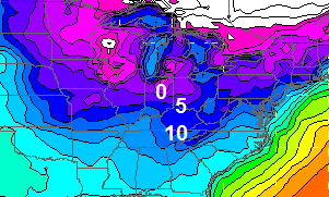
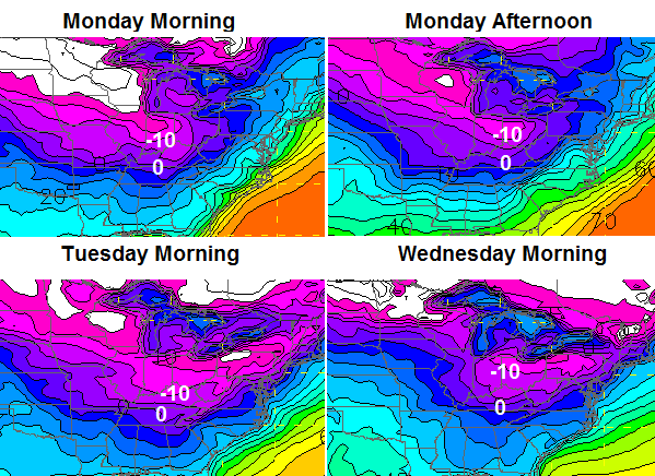
Could be the coldest air in two decades coming later this weekend into first part of next week.
WPC Discussion page – center of cold air in Ohio Valley with readings as much as 40 degrees below normal expected by early next week.
It is pouring the snow in greenup! Sticking to everything now
I’ve seen several times in the last few posts a forecast of “just” 1-3 inches of snow. Realize that if we got that it would be our biggest snow of the season and double our seasonal total. 0.6 inch in December for Lexington and 2 inches for the season.
trust me no COLD like this that coming will come without a THUMPER FOLKS!!! IM ALL IN ON A THUMPER for SUNDAY THRU TUESDAY. OLD SCHOOL is on the way!!!!!!!!!!!!!!!!!!!!!
OLD SCHOOL!!!!
OOK TO THE NORTH/NORTHWEST that were the snow BAILEY talks bout is coming from, the good ole UPSLOP/NWESTERLY WIND!!
How much snow do you think we will get Sunday-Tuesday Rolo?
Please do not trust rolo with your dinner plans much less a forecast.
his forecasts are right as much as anybody else
On the busts he has been pretty good, but on Old Schools I can not recall one. That said, I love when he posts about them. One day from a statistical perspective he has to get one right. 🙂 Or maybe not, at least if CKY is part of it. Such talk anymore now seems pure fairytale.
Of course you can say he’s right when he changes it 15 times in 12 hours. Just about every system that has came through he has said it would be an old school, all rain, and everything in between in the period of three days.
I’ll agree with you when the blowtorch comes haha
I say we get (minus) 8 inches of snow during that period. In other words, enough warmth to melt 8 inches of snow if there was that much around……which there won’t be.
BigPoppaSnow
6-10 INCHES
Thanks Rolo I hope your right!
Temps have really crashed now that the precip is gone. Down to 27 here in Lawrenceburg. I’d rather have a “blow-torch” than this kind of weather.
It will warm up, rain again, and then get cold for a day or two. It’s fairly obvious this is what it wants to do here in KY this winter.
Yeah, how much Rolo? I’m an old school kinda girl and like your optimism for Sun!! ⛄️
LOOK TO the NORTH/NWEST see that dropping southeast. there ur shining hope as its FORCASTED to blow up as it hits KY!! I didn’t say that but that what the forcast is based on. remembner we said yesterday this would move to fast for any snow much and only shot u have would be the ISOLATED SQUALLS, but Bailey says this evening it will be widespread and blow up. we will see.
What another joke in Madison County. 1-3″ lol! A few flakes and absolutely NOTHING stuck to the ground. Still another Dolly Parton snow.
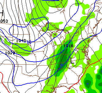
Yes, things will change…but NAM at 75-81 hours out painting at least a couple of inches of snow along the Ohio River. However, ice is also a potential prior to the transition. This is from the NAM, again.
Something is starting to fill in around Louisville on the wunderground radars. Maybe we’ll see some snow yet?
Temp has fallen to 25 in Lawrenceburg. Dusting of snow but brisk northwest winds. If this precip had been all snow might have had 3 inches. Not a big system but enough to enjoy!
22 in Frankfort, wind chills low teens, the cold has arrived as planned we just need some snow to show!
Root for the GFS on Sunday. The Euro puts the best snows well north of KY 🙁 The models, as usual, will go back’n’forth with the specifics, but somebody will gettin’ a white dumpin’!
As rolo said, watch the NW radar … it’s popping around Louisville! 🙂
Im in Louisville this week and it’s snowing decently right now and windy. 21 degrees and its got to be single digits windchill.
I am in Louisville and while it is snowing currently not much accumulation. I wouldn’t get to excited about a back end snow of this nature, the humidity levels have plummeted.
Geez louise people, quit your whinin’ and look to the northwest, good grief!
CB is gonna have to scold you people again LOL. 😀
You all make me wanna draw all the blinds and cry in my beer. Smile a little! 🙂
at this rate we might pick up an inch b.for morning.
do not get your hopes up Frankfurt or Lexington
Radar filling in some, but not filling in much in central yet, nice donut hole, must be the dome 😉
NWS latest saying the snow moving in from indiana is weakening and under an inch tonight at best!
Bring on the Sunday storm, this is just a cold wind with flurries!
Radar won’t tell the whole story… these are very high ratio snowflakes that won’t be picked up very well. Regardless… what the radar fill in in the next hour. 😉
Coming down pretty good in Frankfort now!
It has rained on Martin County all day. I am still waiting for the switch over to snow.
From LMK regarding Sunday:
“The GFS, after trending slightly warmer for a couple
of runs, has changed its mind and gone back to a colder solution and
gives a perfect surface low track for heavy snow here.”
Oh, snap!
If CB does not go into that mode, it is just words. Just words.
That said, even when going into threat mode it is just words for a lot of CKY 😉
Winning!
That mode, that mode. All the same really.
I think they were waiting for the other models to get into some agreement. The GFS has been all by itself lately. If the GFS verifies, 6-10 inches on some runs. Merry Christmas and Happy New Year!!
deceptively slick in lexington-be safe!
Gee..Tough crowd..I believe some in here would tie all weathermen to the stake and burn them..lol..Big flakes flying in the air right now in Perry co crossing into Knott with the wind really picking up..Never seen huge flakes like this before..Looks like coffee mugs flying through the air..Upslope kicking in..
Down to 22 in Lawrenceburg. Just saw some guy with a big truck spin out and run over the curb. A four-wheel drive doesn’t do you any better on ice than anyone else.
Dome-Busting happening in Millville, I believe! Snow came in from the west and it’s starting to get white outside! Thanks, Chris, for all the updates.
Well Bailey has nailed it, look at it filling in!!!!I was wrong, look for 2/4inches for sky and east ky 1/3 central
Wow 18 degrees in frankfort, on and off snow showers, donut hole trying to fill in around frankfort!
Meanwhile GFS keeps on trucking along for Sun-Mon event..May not happen but never seen the GFS go this long without waffling..
I will say here in Louisville this squall that is moving through has produced more snow accumulation than I thought.
And someone told me I was wrong that the radar wouldn’t fill in later in the day, this morning. Sighs
What? You mean to tell me one of the negative Nancy’s and Debbie Downer’s were wrong???
According to radar, London hasn’t had snow for over an hour, BUT everything is white, we just saw a truck slide across hwy 192, streets are getting snow covered, and blowing snow is billowing off of roof tops. OVERACHIEVER ALERT!!!
I have got no snow so far but we were not suppose to get till this evening hoping it changes to snow soon.I just saw Chris on wkyt looks like its coming down there,Chris send it to me lol.
It is trying its best it is sleet now.
Headed home from Lexington at 5pm, Richmond Road was slick and 75 too with swirly snow on the road and steady medium snow falling. I get to Clays Ferry bridge and like a light switch again. Not much on the other side. Crazy river effect.
It is odd how the river seems to control such things.
Our local met just said accumulating snow Sunday into Monday with brutal temps below zero…could it be true!!!!??
I notice that weather.com keeps lowering the expected temps for my area. They were not buying the cold or where at least not showing it in the forecast. Then they did the usual and started lowering the expected temps. Hit the upper 20’s then low 20’s. Next was mid-teens. Now, they show 10 degrees with a low of -3. They have even really lowered Tuesday as well. I put no stock in what they show but when they start to move to what Chris has been showing might happen with the models that usually indicates that the signals are getting pretty strong.
Frankfort might end up with about a half inch, but hard to tell with wind blowing it around, toe biter number 5 this year! Around 3 inches total for season!
CB spanked all you pessimist cry babies! Give the man some RESPECT!
Rolo already stepped up for the plate full of crow! Plenty of room left
At the table!
I guess you are the accountability police. Lol. You are just as bad as the so called crybabies.
Leg or wing Ben?
With chicken I am a leg guy but I am not sure crow would have much on either. I could be wrong though.
Only have one crow and MANY mouths to feed! 🙂
Haha nice.
That makes no sense. How about English please.
I will admit fire that I do need to be more positive. I should not had commented. My apologies.
I’ve been looking at models and i’m just super disappointed by what I am seeing for this Sunday storm. I was really hoping to see atleast 3 inches of snow here in eastern kentucky. But, that just isn’t going to happen. We’re going to get a rain even switch over and everybody knows how that goes.
As long as we dont get a ice storm, I’ll be ok with it, but I would like a couple inches of the white stuff.
There are 3 GFS analogs I’m looking at which match closest the 500mb forecast for late this weekend. One was a January 20, 2011 analog that produced 3.6″ snow for Louisville followed by readings in the mid single digits for the next 2 nights. Some of the other analogs show tremendous amounts of snow in excess of 6″ for several areas of Kentucky and Indiana.
I would have to research the weather maps for those dates to find out the position of the surface low and adjacent weather systems.
oh, dates for the outher ones?
Snow coming down harder than it has all day. Down to 19 in Lawrenceburg.
Again I want to say thanks for the job that you are doing keeping all of us informed of the dangers of this system. The rain started here around 4pm CST, and the temps have fallen 10 degrees. I will keep reading for more updates.