Update
Good evening, gang. Your friendly weatherdude will be going in to pull tv duty later this evening as the arctic front arrives. You will find me on your tube with updates later in the evening on WKYT and on WKYT at 11.
I continue to keep the same forecast rolling on with no changes. I want to stress… don’t waste time tracking snow or dry air from the low pressure system. Our snow comes from the building band of snow that develops behind it this evening and overnight. Snow showers and squalls will follow that up into Monday. Will this setup produce more snow the farther east we go across the state. How ironic would it be for areas under a winter storm warning to get less snow than areas that were never in the warning?
Road conditions will become hazardous as the temps drop and the snow kicks in. A flash freeze with snow on top is going to create a ton of traffic issues tonight and into Monday. Remember… salt won’t work with the bitterly cold temps that roll in tonight through Tuesday.
Those temps and wind chill numbers are going to be dangerous! Please respect this cold blast and take all necessary precautions to protect life and property.
Your trackers are below… take care.
Previous Update
Good Afternoon, everyone. The arctic front is pushing into western parts of the state and will roll eastward, but won’t clear the state until later tonight. It’s just a tad slower moving and that means our temperature drop is going to be that more impressive. Many areas will be more than 50 degrees tomorrow than they are today. Ouch!
Here’s the rough estimate of when the front reaches your area…

Overall… NO CHANGES to the thoughts I have had out for days, now. The change to snow behind the front is fast and furious and it’s going to snow hard for a while. This band of heavy snow will drop quick accumulations and will combine with a 20 degree temp drop in an hour to create a major ice up of roads.
Snow showers and squalls look more widespread overnight into Monday morning than I was originally thinking. These will have a serious fluff factor and could be similar to the ones we had a few nights ago. The GFS shows these cranking all the way through Monday evening…
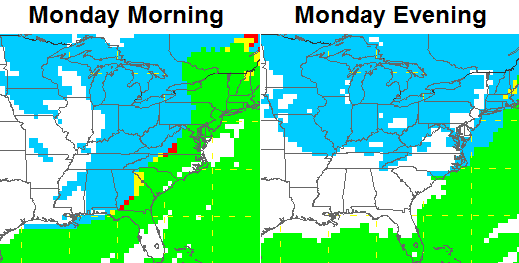
A general 1″-4″ of snow will be likely before all is said and done.
The cold coming in behind the snow continues to be the main story. Readings drop to below zero during the day Monday and will stay there through Tuesday morning. Record lows will be possible both days. Wind chill numbers will approach -30 at times during this time.
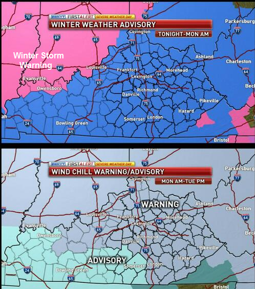
Here’s a look at the latest advisories and warnings that are out for the region…
Let’s track…

Current temperatures

Winds

I-75 @ Winchester Road Lexington

I-75 @ Iron Works Pike Lexington

I-75 @ Clays Ferry Bridge South Between Lexington and Richmond 
US 60 @ US 127 Frankfort

US 127 @ Frankfort Frankfort

I-75 at MP 36 London

I-71/I-75 at Buttermilk Pike Near Covington

I-64 @ 3rd St. Exit Louisville

Downtown Louisville @ 2nd & Broadway Louisville

I-65 @ 234 Near Bowling Green

I-24 MP 4 @ US 60 Paducah

I-24 MP 7 @ US 62 Paducah

I will have updates as needed and will likely grace your TV late this evening on WKYT. Have a great day and take care.

thanks for the update Chris.
here in Louisville right now the Sun is peeking through the clouds. as the radar shows it is raining. it might be a weird weird day here in the Commonwealth.
be safe and optimistic people.
Looks like a dry slot already forming behind the rain shield.
BPS
53 degrees on a South wind here in Lincoln county, what a bust! Just joking. 😉 We’re ready for the cold and snow. Everyone please remember to top off your antifreeze too.
Think Spring!
Better pray to the snow squall god that he may do what he did last time when the dinner was the appetizer and the dessert was the main course. (When we got little snow but the snow squalls saved the day and CB’s forecast panned out)
Is this the Blowtorch you guys were looking for in the CPC’s 6-10 day outlook. http://www.cpc.ncep.noaa.gov/products/predictions/610day/index.php
Thank goodness… I’m sick of this winterless winter already…
the rain and snow line appears to be about 90 miles north of Louisville.
as of now I am enjoying the Sun peeping out of the clouds
Yeah, I noticed the sun out a few minutes ago. The streets are sweating today. They were dry last night but a lot of salt on them. As the temp has climbed, they’ve gotten pretty wet, at least in my neighborhood. Anyone know what causes this?
you have to admit Louisville weather has to be the most unpredictable in these parts.
Always right on the edge. Going to be an interesting evening to see how things play out.
Salt attracts moisture. The dusty coverage on the roads is pulling moisture from the air.
Looks like a frontal event now for most of KY. Quick period of rain then flash freeze. Very little snow accumulation if any.
http://models.weatherbell.com/news/hrrr_current_east.gif
thanks Chris-good luck to your Bengals!
psyched for the approaching snow & cold.
Wind picking up in southern KY.
Looks like a little swath of rain is around Bowling Green. Winds have picked up here considerably and clouds are getting thick in a hurry! Temp is mild though. 52 right now at my house.
Is it the ice and cold air we need to be worried about?
Temps nearing 60 degrees now in many areas! That’s just a crazy temp crash!
So since 57 right now in Richmond and Winchester, does that mean no negatives? 57-50 = 7. Wind chill will get it down, but not the actual temperature. Everything is relative!
Actually it is getting warmer than 57 now. 50 degree swing from there is not negative temps. So we will have a 60+ degree swing to get us to the expected negatives? Not seeing that, but would be wild if it happens!
Yeah, this thing is turning into a huge joke. No way we get a 70 degree temperature drop (60 to -10), just no way. Expect a little rain this afternoon, some strong winds then temps into maybe the teens. Zero for sure, but zero snow, not temperatures.
BPS
4 inches or less means no negatives IMO just have to wait and see
That would be wild. I’ve never seen that kind of drop. It is 53 in Lawrenceburg. Actually a very nice day! Washed the cars, went for a job, and now am settling in for some football. Feels like March out there to me.
jog not job
Hey, to some of us, a jog is a job…..and a very difficult one at that!
BPS
LOL! Indeed!
Well, washing the cars was for sure the kiss of death! It seems like every time I wash our cars it rains the night or the next day. I”m being serious when I say that my left shoulder which has been operated on 4 times usually hurts when a winter front moves in and it is not bothering me at all right now. I hope that’s a sign it’s not going to be as bad as they are saying. Stay sate everyone.
I think we will be hearing mets tout the wind chills and not the actual temperatures. All joking aside, a 65 or so temp swing would be nuts. We shall see……..
Not a fan of super cold myself, since I worry about the critters that are left outside.
The models have done a absolutely terrible horrible job with this whole system
Agreed!
Especially the awful GFS.
61 and sunny in knott county
I just called my sister near Indy and told her to quit Hogging all the snow lol.She said it was really coming down and she doesn’t want it. I said please send it to us snow straved people in Ky.
I just pray no one loses their life.
Amen to that, Chelle!
Looks as thought the rain line has not moved east at all. It looks the same as it did at 730 this morning.
Going to get really cold later tonight…No Snow for Lou. Is my prediction. If any it will be a deck duster with a bunch of frozen puddles.
Look again towards western ky its moving. Carbondale Illinois was 34 with rain an hour or two ago now Carbondale is 27 with heavy snow and temps falling. Henderson KY reports of sleet mixing in with rain.
I looked through the records to try to find a 60 degree temp drop in one day. On 1/18/63 an arctic front plowed through Kentucky. Temp fell from 42 to -13 in Louisville, From 45 to -21 in Bowling Green and from 47 to -24 in Cynthiana (a 71 degree drop!). In November of 1911 Lexington fell from 70 to 14 during a day. It has happened but it is very, very rare.
They’d probably blame that on Global Warming today.
Rare, just like this event
Where do you find all your weather data and statistics? I always see you post historical things and I look soooo much online on where to find it.
Good thing some of you aren’t paid to do this. Your negativity is comical. There’s no need to take the weather so personal or say this system is a joke when it’s only 1 pm. Done reading the comments from here on out you all are clueless as anyone when it comes to weather
I didn’t live here in ’94 for the “SKIFF” any resemblance?
No–in ’94 it barely got above freezing the day of the big snowstorm and when the precip started it was in the 20’s and as freezing rain.
The front is pushing into Paducah as I type this
Yup the warm air convection has made the artic front angry its on the move now. Artic front has had about enough of the warm air convection stealing the show.
Good point. I wonder if the warmer air actually makes things more volatile. Maybe part of CB’s master plan 😉
Temps have skyrocketed today warmer than the models thought. Perhaps we are lucky enough that the temps don’t get as low as the models think?
Just had a 30 mph gust of wind here in Richmond, and it is getting cloudy now.
Just had a 30 mph gust of wind here in Richmond, and it is getting cloudy now.
Sorry for the doublepost!
Where’s Bryant? Today is a “blow-torch day” I’ve gone from 28 at midnight to 54 now.
Yep, you would think he would be basking in the heat today 😉 We hit 58 in north Richmond. Unless we get some decent snow sitting around, I think the big story is the wind chill and not the actual temps for negatives. Such a big swing though would be impressive to say the very least.
I must admit feeling dubious about my ankle biter call now, since need 2″ of snow for that. CB should be covered with the 1″ to 4″ call. Maybe I should have said toe to ankle biter 😉
CB is holding firm, so since he is a proven met, wise to listen to the man 🙂
The NWS is holding firm on the idea of 1-2 inches. Seems like big surprise is how warm it is today.
LOL, just got back from walking the dog, and realized I like this weather. If we can’t get the big ticket snows anymore, this beats 40 degree rain and mushy back yards with gray skies.
The NWS in Louisville has issued just about every kind of weather advisory that is possible…Winter Storm Watch to Winter Storm Warning to Winter Weather Advisory…can we maybe get a Heat Advisory before the afternoon is out?
I’ve never seen a Wind Chill warning with the temp at 55 degrees.
First time for everything
It’s currently 51 and mostly cloudy in Versailles. I trust Chris’ forecast 100%. I think a lot of people are underestimating what will happen when that front pushes through.
Why wont it post it comments!!!!!!!!!!!!!!!!!!!!!!!!!!!!!!!!!
Got 52 degrees here in St. Matthews, winds picking up from S around 20 mph and my surface pressure at 29.64 in. Lou Mayor Fischer has press conference at 3 PM, I presume about weather, not Charlie Strong. No impending signs of rain here yet.
Whatever model had the heaviest snow from St. Louis to Indy (I think the Euro) is winning out. Chicago had even had 9 inches. The St. Louis news says this will be one of the 5 worst storms in the past 50 years.
GFS still showing 2-4 for coal country. 55 degrees right now in Harlan county. Hoping everyone gets in on some snow. Keep a small stream flowing from your faucet. Might save you a big job. Sit back, sip some Kentucky bourbon, and enjoy the snow. Be safe.
GFS still showing 2-4 for coal country. 55 degrees right now in Harlan county. Hoping everyone gets in on some snow. Keep a small stream flowing from your faucet. Might save you a big job. Sit back, sip some Kentucky bourbon, and enjoy the snow. Be safe.
Irvine – Temp. a little over 50, wind gusting, some sun, and now cloudy. Wind has really picked up speed in the last 15 minutes. Chris, glad that you’re here to tell us what is comin’ our way!
Fulton County very western county in Kentucky temp has dropped to 35 degrees.
A question for you more knowledgeable folks. If the front is slower than expected will more moisture fall before the front? Appears that way on radar. I know the focus is on brutal temps and not snow, but that would lower totals?
actually I do not think the radar returns out west are not bad.
I think a couple inches is not out of the question.
at this time I will take anything we can get.
remember snow is an insulator.
Hard to say due to the flow (hence the mets all over the place). You can see though what CB is referring to. It is kind of like the wake from a boat. The boat is moving up though St Louis and Indiana, etc and the map looks like a wake is heading our direction along with the cold air. The wall of snow CB expects I think is the wake.
The “boat” path though is getting smacked and then will get super chunga cold. If anybody recalls 93, that snow was like snow cement once it settled in with the cold. Hard to shovel unless you did it while it had just fallen.
We need to get a nice snow even of 6 or more inches, but I wouldn’t mind 12 or more inches. It has only snowed a total of an 1 inch, maybe 1.5 inches, and the last 2 previous winters combined the snow totaled less than 1 inch. We are snow starved and need to make up for the lack of snow the past few years.
Nothing says a Kentucky winter like a near 60 degree balmy day, followed by a skiff of snow with 2 days of bone chilling weather, followed by yet another model busting rain storm. Depressing
Torch!
But the torch will go out for a 2 day run of cold temps. Only to be reignited.
I hit 58 a few minutes ago. This might be the warmest temp of January. I think this low pressure is stronger than anticipated. That’s what has caused the temps to go crazy today. If I remember right, the stronger the low, the further north it would go. They must be having some kind of storm in Central Indiana and Illinois.
Correct. Seems a lot of us might not go below 0 tomorrow and will not on Tuesday unless we get full snow cover on the ground.
We might be hearing a LOT about wind chill temps rather than actual temps, especially if we do not hit negatives for actual temperature.
Perhaps we are going into “snow globe” mode tomorrow. A lot of stuff flying in the air and not much on the ground but a toe biter at best.
Looking forward to CBs update 🙂
I had 1 above on Friday with just a small snow cover. I’m not sure what the wind chill was. I’m doubting Lexington will go below the -7 from 2003 or the -6 from 2004. It has now been 18 years since Lexington has hit -10..that’s the largest gap I can find in the records.
That Kentucky winter heartbreak.
Goes to show you should never get excited about what the models are predicting 48 hours or more from a storm. I’m sure the models have improved the past 25 years but they are awful in the winter.
CB,
Thank you for this website. I follow it often. I do notice you never upgraded from a winter storm threat to a warning on this site. Is that because you no longer believe the snow totals to be worthy of an upgrade? So we are expecting less than you initially thought?
Fingers crossed we get a surprise when we wake up.
Well, if anything, today sure is a nice day to open the windows ahead of whatever we get. It’s nice out.
The rain has finally made it’s way into Louisville. Belski is calling for a soaking rain for Louisville. Can the cold catch up with the precip? We shall see.
I thought he is the same person a few days ago that called for the low to drop 100 miles, so be careful 😉
What is the temp in Louisville? I have to drive over tomorrow morning to the East Side for work. 56 here.
It’s 52 at my house near Seneca Park but in the upper 30’s about 30 miles west of downtown. Pretty heavy rain at the moment.
At least Southern Indiana is not going to see 6-10″ of snow. Those folks get to share in our misery too.
Temp has dropped from 55 at 12z to 51 right now in harlan county. Hoping we get some snow.
54 degrees in New Albany, IN at 2:30. Will be interesting to see how quickly the changeover happens.
Why does nobody have a profile on here. Just click on the picture icon and create a profile!
Our once beautiful 4″ snowpack up here in Northern Kentucky has now been reduced to patchy areas that are rapidly melting. So sad. Oh well so far we’ve had 17″ this winter, so we only have 6 more inches to reach our 23″ normal snowfall. LOL
I’ve had 4 inches! A little in October, November, December, and January. Just enough to make sure I wash the car every week 🙂
Its amazing the contrast this year. I mean, you guys usually get a little bit less than us during storms, and you miss a couple that nail us, but you shouldnt be that far behind!
51 deg here at 2:30 wind is picking up some! But the timing of this seems to be after everyone gets in from church this eve so that is a good thing!!!!
Wow, 53 today here. If we manage to stay warm and then the front does quickly fly though that would be a fairly big temperature drop pretty quickly. Crazy weather in Kentucky.
Just saw a tweet saying maybe 50 degrees colder tomorrow. It was 61 here today, so 11 gets very close to what I predicted earlier, into the teens. No -10 in sight, so the pros miss by 20 degrees!
BPS
We got colder than that during this past event, so that seems unlikely for this one. After all, it is THE ARCTIC FRONT!!!!!!!
🙂 😉
Chris… my wife’s family lives in South Haven (Portage) Indiana… since 5 PM yesterday, they have gotten well over a foot of snow… still snowing and still getting colder!
Oh boy more blowtorch talk…..amateur comedy night tonight?
Just like the Bengals trying win a playoff game! Comedy 🙂
Marvin needs to go. Point blank. If the Reds can fire Dusty for postseason incompetence, Lord know the Bengals have plenty of reason. Last playoff victory: 1990? Unforgivable.
BUNGELS LIVE!
And now intercepted (just like our snow)….OUCH!
BPS
It’s funny how people bloviate about another bust before the front has even moved through.
Given the trend, it’s safe to “bloviate.”
Cincinnati should win. Seems that the team that turns the ball over the most comes back and wins so far in these playoffs. At least in the first two games have went that way. Bengals are getting their turnovers in and then should be ready for a comeback.
So much for wishful thinking.
I bet the fans would like a torch right now. That would suck paying all that money and sit in the cold rain to watch the Bungles do a Dalton.
That is a new phrase for messing up: Doin’ a Dalton. The Bungles offensive line has been offensive and their defensive secondary also been offensive. Both offensive in a bad way.
JEEPERS, he did it again as I was typing. Dalton did a Dalton!
The radar is sad, looking at back edge of good moisture just west of Paducah and moving north and fading!
Just a bunch of cold air and dustings! Bring on the warmer weather!
I said earlier you could already see a dry slot behind that rain.
BPS
Todd, were all going to get in on confective snow showers and squalls snow ratios will drop it wont take much to accumulate
Hope your right?
I thought most of the moisture would be behind the front.
Now now! That would be listening to what Chris said very clearly. That ain’t how pandemonium works 😉
Jefferson County has already cancelled school for tomorrow.
It is 52 and raining in Shelbyville.
Typical Kentucky Educational System overreaction!
I think with the temperatures and wind chills they always cancel like that here. I know that some students have to stand out and wait for the bus and in that cold it could be dangerous. Might be why they are already cancelling and might not be overreacting at all but I do not know about Jefferson County.
My point is, why not just wait & see what actually happens before cancelling school. These forecasts are so bad that we might be looking at 15 degrees & calm tomorrow morning & that wouldn’t be a reason to cancel anything.
BPS
As a parent and employee its nice to know things prior to 4:00am in order to have a contingency plan.
Sometimes I think they want to error on the side of caution since it would only be 1 day. I have lived here since before my 8th grade year. During my 8th through HS time many times we had school when the forecast called for bad weather. The weather would hit after we hit the bus or where at school (and not even to the first lunch at 11:00). I remember riding to school on icy roads and getting there over an hour late only to reload and make the slow dangerous journey home that first year. I can remember that happening a decent few times overall. And a few times they had buses stuck, on the morning pick-up, with students on them.
And recently, they cancelled school at the last second. Literally. Some of the drivers had started their routes. And we missed the next day as well because of bad roads.
A school employee in Knox co. hit black ice and was killed this week in a crash. Was heading to the school to cook that morning and must of got out before it was called off. Why wait and nowcast when all the experts say dangerous situation
Is coming.
Agreed! “Erring on the side of caution??” More like “Better safe than sorry.”
They should at least wait until the morning. What IF it did not get super cold or snow any. Possible.
Wonder in Madison will call school of premature again? They did that for an event a few weeks ago and did not exactly work out for them. They canceled school the day before and Nothing fell the next day.
I concur BubbaG, you’d think they’d learn to have a little patience & at the very least understand that the over-hyped forecasts are generally wrong more than right!
BPS
So what if the forecast is wrong. Would you want the death of a student or employee on your conscience because you wanted to wait to verify a forecast??? I would much rather them be cautious than foolish. Better to be in school an extra day or two than to make a mistake and put lives in danger.
And yes, I agree the forecasts are over-hyped.
well folks it just started snowing in Paducah this should give us an indication on how much snow is behind the front.
if we get 2 inches here in Louisville I will call it an overachiever.
trust me I am NOT moaning are complaining.
you take what you can get here in this climate.
by the way quarterback Dalton= weather models
the Red Sox finally broke the curse it took around 75 years. maybe before we all die we will break our winter curse.
WWITWB, just like with UK football, I don’t think I’ve got that many Winters left in me…….
BPS
60 degrees and a steady rain in Bowling Green right now. No doubt that we’ll be in the deep freeze, but in terms of snow, it’s looking as though Bowling Green residents will be left out in the cold (as usual…).
Yep, this looks way overblown (pun intended) but the TV stations get their viewers & the grocery stores get their customers, so I guess all is right with the Weather World!
BPS
What isDalton doing? A bomb on 4th & 3??
And now the Mesonet goes down, reliance on technology can have its frustrations.
BPS
Temps crashing causing mesonet site to go crazy lol
Temp in NE Louisville went from 56 to 40° in just 1 hour (2:30 to 3:30pm).
well at that rate it should be snowing here within 15 minutes
And from 3:30 to 5:30 it raised to 42°…
Go figure. Wacked weather!
I really hope dry slotting won’t be an issue for southern KY/northern TN. It seems this band of snow will be very VERY narrow. :/ Quite sad.
You’re right CF, just look at that tiny, tiny, tiny sliver of snow on the far west edge of the radar view. Pitiful, pitiful……
BPS
Paducah is down to 27 degrees.
if they’re going to receive an accumulation that sliver of snow better be coming down real heavy.
Ruh roh!
I wonder if the Bungles have pushed CB to the Dark Side for the next posting?
Nah… it is what it is. New NAM shows the 1″-4″. Forecast in good shape.
Chris I trust your forecast I’m not sweating to bad just really want some snow but if not oh well life is good… We all need to say a little prayer for all the people out there homeless with all this cold coming.my heart goes out to them i wish my house was big enoungh to take them all in…..
Reading the frustration on his Twitter feed toward the Bengals reminded me of how I felt last winter after so many consecutive busts for my area.
Hopefully, he will fare better than I did and stop before he gets to researching pagan rituals for influencing climate. >.>
I just saw another forecast mention that snow squalls will start firing later tonight. First time I’ve heard that other than from Chris. Fingers crossed.
I called for all rain in Louisville two days ago. I think I will be right.
I remember that & completely agree. Temps went way too high today, IIRC originally today was to be in the 40s max.
BPS
So did every other met (armchair or not) here in Ky. No one said it wasn’t going to rain. I said it was going to rain three days ago with snow accumulations North of the River. CB forecast of 1-4 with dropping Temps will hold true. As for the wall of snow heavy at times not seeing it happening.
Can’t believe that my kids are outside playing in 55 degrees and sunshine, with the snow just hours away. Hoping that the hint of snow developing in western TN is a good sign for London.
Just read the entire 4pm update from the NWS Louisville, they are seeing the drying trend on radar and dropping snow totals to 1 to 1.5 inches for most of KY!
I will be surprized if that much falls looking at latest radar trends!
Deck duster might be in question??
7th deck duster of the year if that happens. When it comes to snowfall amounts from Trace-1 inch Central Kentucky rules!
Todd!!!!! One more time snow showers/squalls will kick in to full gear later on tonight. Some might get a dusting others will get more.
Those are usually reserved for the east ky highlands, west of I-75 gets very little back side snow squall action, lived in this area way to many years to think anything different!
Oh well then carry on lol
Still around 50 degrees in the London area.Looks like the swath of rain has gotten a bit wider.Sure hope we don’t end up with ice all over everything after the rain comes through and the flash freeze temperature drop.I can’t believe how warm it has gotten today.If we go below zero tonight that is one heck of a drop.
I cant believe all the people out jogging in shorts.
Haha everybody jumping ship as always. Then tomorrow you’ll act like you knew it would snow the whole time. Wait and see. So far CB is right on with his forecast.
Here’s to hoping that is true!
This is true, but what would be worse though is if they are actually right and then you will see chest thumping like you’ve never seen before. Bashing CB, bashing models, bashing Kentucky weather, bashing ankle, toe, heel, and arch biters, and just bashing in general. They may start rioting before long.
He said don’t worry if its in the 40s today… how about well into the 50s. Don’t think your statement is correct
I could not believe all the people out in shorts.
Unless the look of the radar changes, the deformation axis in Southern Illinois/Southwest Indiana is the only real shot at accumulating snows for KY. This shows up well on the Evansville radar and looks to clip the counties along the Ohio River.
Agree, the low is moving north east and will take the good moisture with it, most of ky will be left out, I know backside flurries and squalls?????
18z GFS looks pretty good for E/SE KY. Showing 3-4 inches with isolated 4-6.
Really?
I’ve always been in the warm up and rain and then a quick flash freeze event. That seems to be playing out across most of KY. Low pressure center is currently near the Ohio River in southern IN, Very little moisture on the backside of the low will mean a snow shut out for most of the state unless some of the cold air can inject itself into the quickly into this system. That seems highly unlikely with all the warm air around though.
Some winters its just doesn’t want to snow. Sometimes it just wants to warm up rain and then get cold that seems to be the pattern we are stuck in here.
Does BigPoppaSnow or BubbaG have a degree in meteorology? I’ve never seen two people spew at the mouth and try to slam a person behind a keyboard more than these two slaps! I heard the Weather Channel has a couple of job openings…..Maybe you two world renowned armchair meteorologist should apply. Im sure Chris Bailey would highly recommend you! Keep up the good work Chris!!!!
Quote from last update
“I continue to keep the same forecast rolling on with no changes. I want to stress… don’t waste time tracking snow or dry air from the low pressure system. Our snow comes from the building band of snow that develops behind it this evening and overnight. Snow showers and squalls will follow that up into Monday.”
Sounds as if the snow will develop later that may come over our area.
Which is a nice CB way of saying for everyone to stop whining and complaining in the comments section!!!!!!!
We’re not whining & complaining, we’re just saying that we can look at radars, sats, the mesonet (when it’s working) & do a decent job of predicting the weather, too….and today, maybe better. If one of the pro’s wx forecasts ever comes true, we will give credit for that.
BPS
Sounds a lot like whining and complaining to me.
Yes, in this day & age, telling the truth bothers lots of people.
BPS
If it was the truth it would not bother me, but you all just spout out random things that aren’t true half the time. CB himself said to not worry about the line of rain that the snow would be building in behind it, yet you think you know more than what he does and of course complain 30 times an hour about how it’s all rain and you were right all along, blah, blah, blah. It gets really old! The comments section used to be a really useful tool, but now it is just turning into an all out gripefest.
Everyone has downgraded to an inch or less… CB will be the only one correct if he sticks with more. He just has a tendancy to overestimate 60% of the time every time.
Well said. I don’t mind people saying what they want to say and moving on. It gets annoying though to try and follow the comments section when the same people post the same whiny crap over and over. The whole smartest guy in the room routine gets old fast.
perfect!
I’m glad I’m not the only one that thinks this! I am thinking we are a (mostly) silent majority though.
yes!
You also must remember that CB isn’t just forecasting for you and your neighborhood. If he says 1″ – 4″ and you get 1″ and others get 4″, then he was right. He forecasts for many different counties and cities. He has been doing this much, much longer than most and knows exactly what he is doing. It’s a prediction, a forecast. He is THE BEST met, period. He is usually 100% right on the money. Thank you CB for what you do. Thank you for taking YOUR time to do this the right way instead of taking one model at face value. Your forecasts and caring for the people of KY are much appreciated… By most anyways.
I am always reading comments but never comment myself but wanted to get Chris’ opinion or someone else who knows more about weather to answer a question…I am a teacher and wanted to know would it be safe for kids to be out in this kind of cold? I remember one year I was out for cold but not this cold…thoughts?
umm did u get out and go to school when it was cold back in the day? r u still breathing ? lol
As long as they’re dressed right they’ll be fine. If it’s 15 degrees, there’s not a thing to worry about, but the nanny state is trying to eliminate all personal risk across society. Good luck with that. When I was a kid, if we went out & got cold, we came in…..it’s really not difficult at all.
BPS
Wind chill of -20 is something to worry about.
I don’t think it’s a good idea for them to be out in that kind of cold. Just a few minutes of exposure at the kind of wind chills we are forecast to get could cause frostbite.
I’m just glad the guys that landed at Normandy (D-Day in WWII for people that don’t know what that is) didn’t live their lives like that when they were children!
BPS
I couldn’t agree more BPS. Common Sense was actually common then. A lot of people in this area made what they had and didn’t care to work for what they didn’t.
Preach on CGM40, looks like we’re a dying breed!
BPS
Their mothers would have cut a switch on them for going out without their coats, hats, and gloves! They would not have survived long enough to have made it to Normandy if they didn’t have enough sense to know when to get in out of the cold.
Did someone mention D-Day and weather?
http://articles.chicagotribune.com/2009-06-07/news/0905110054_1_partly-cloudy-skies-low-tides-weather-updates
Interesting article, LD.
It’s actually kind of funny thinking how today’s meteorologists would have predicted the weather for an invasion like that. We’d still be waiting for the go-code 70 years later. That wx forecaster during D-Day had some GUTS!
BPS
Here’s a link to James Stagg….the man himself:
http://en.wikipedia.org/wiki/James_Stagg
BPS
I know that I don’t want my kids out in it, that’s for sure! So many kids walk to school now, and that would be extremely dangerous for them to do in those kind of temps. Even just waiting on the bus outside is not good. I think it’s smart to cancel based on extremely cold temps and wind chills. Why take the chance?
I am not sending my kids to school in this extreme cold. The funny thing is, the Lexington-Fayette county urban canceled trash pick up for Monday but the school superintendent has not canceled schools yet. Really??!!?
Just started raining here in Richmond a few minutes ago.
Only thing I am complaining about is the ton of rock salt I purchased New Years Eve for the supposed to snow 1-3 here in Lou in which we got rain and deck duster. Left it on there for the potential 6-8 GFS…snow that was forecast as early as Thursday with the issuing of a Winter Storm Watch Friday…New it was going to snow this weekend…Down graded to Advisory Sat. Salt Still there. Now I was hoping I would be able to get out this evening and throw salt. Not going to happen. I guess I will leave it on there for the Wed/Thur/Fri system that is suppose to drop some snow on Kentucky..HA Ha HA…..IBIWISI…..
This stuff is even more frustrating for you since messes with your business.
So as much as I wanted to see what they are getting in the Midwest…No thanks…Would have been our working in 0 degrees and below temps. That is no fun.
Statistical question:
So tomorrow temp is supposed to be falling to around -1 by noon, right? So, let’s say for arguments sake that we do only get 1/2 to 1 inch of snow. I wonder if temps like that have EVER happened with such little snow since records?
In 1985 we had very little snow on the ground and a day that stayed in the low single digits all day. Nashville actually got the snow (about 6 inches) and fell to -17. It was the day they had to cancel Reagan’s inauguration parade due to the cold.
I love your stats and info.
I’m speaking of extended below zero temps of course
CB’s speculation about the non-WSW areas receiving more in snow accumulation than the areas inside the WSW is interesting.
That last Paducah traffic cam is starting to turn artistic on us.
http://rwis.kytc.ky.gov/itscams/D01/current_0240107.jpg
R.I.P. KYMesonet
Temperature dropped down to 43 in Shelbyville but it has been rising for a while now up to 49 at 6:15.
Roads icing in Hopkinsville
54 Here in Corbin…Wind starting to blow…..
Why does Dodger get excited about snow chances only to get dusted again and again? Dodger is bummed.
It’s just the snow beast in us Dodger. BigPoppaSnow wants it to snow so bad…..2-3 feet…..even 4 inches will do right now, but as you said “dusted again & again.” It’s our lot in life……..
BPS
I am from NY where they hardly ever cancel school or work,but on occasion they do. We always dressed in layers,but I remember the cold well. When I moved here I was very surprised how easy school was always cancelled and also realized the natives here are just not used to what I am used to so I went with the flow. Instead of stressing how when or if the schools close just use your own judgement.If as a parent you feel zero and below is dangerous (and it is for all involved) then just make a parental judgment call and keep the kids home.If you work and make that desicion now then you have plenty of time to make other arrangements.Im watching so many parents stress across social media about not wanting to wait till 6 am to find out,well then dont. Just my opinion. Thank you Chris ,I follow your reports and find them very helpful !
I’ve been sitting at 43 degrees for the past two hours and in the last ten minutes the temp has gone up 4 degrees. Wind blown rain hitting the windows right now. What a weird day.
I was thinking the same thing KellyinLouisville.Such high temps seem so odd especially with such cold ones to happen within a few hours.Been an interesting couple of days for sure and I have to admit I am intrigued as to how this will all end up playing out.I suspect once the temps drop though we will see a lot of icy conditions and it will be a mess even if there should be no snow at all.
Temperature here has gone from 43 to up to 50 now.
I notice the game tonight was expected to be -7, but it is 3 degrees. That is a fairly huge 10 degree difference. Is the cold air moving slower, or is this going to reflect on warmer temps for us? Well, single digits instead of negatives. You would think where Green Bay is they would have the colder temps now.
They are spouses to be a lot colder than us and are not even below zero yet.
Supposed
Yep, that’s why I think it’ll only get to the teens here tomorrow.
BPS
Considering we were colder than that already, that would be rather anticlimactic.
It’s 50 here & not a place in KY under 20 yet. That’s some odd math you’re working with there!
BPS
My guess is single digits.
Interesting “front” line on radar. Is that the front riding I-65? Snow reported just west of Nashville. Also, keep your eyes on stronger band of precip developing in Tennessee. CB may have been talking about this with his last update.
Good post. We need more like this around here!
I just checked the hourly details at accuweather.com and we dont have a big chance for snow all through the night now.Seems to be rain or a mix for most of the hours.I am thinking we wont get much snow but may end up with a big frozen mess once all this rain freezes.I hate ice on everything and would much rather have snow.It could get very dangerous if all the rain that falls freezes.
I am glad people like BPS think they are God’s gift to manliness because they are so tough. Your weather “expertise” is fun to watch too.
Thank you sir, you may genuflect in my direction on Monday.
BPS
Couldn’t have said it better myself. Tough guy that whines about the weather like a little school girl
Desolation
You may genuflect tomorrow also, sir.
BPS
I normally agree with you on most things, Jeff, however I can’t on this one. It is not about being “tough,” it’s about having the common sense to take care of your self in extreme cold like what is forecasted. You should not have to receive advice from a meteorologist on how to dress your kids or if it is safe to go out, common knowledge should tell you those things. Everyone expects things to be handed to them on a silver platter and it shouldn’t be that way.
Go ahead and bash away.
I’m a paramedic. You would not believe the lack of common sense I see in the field. I just prefer to keep quiet most times.
I can only imagine. Thanks for doing what you do.
….. I thought you were the actor 🙁 …… 😉
All this talk about the good ol’ days and people being tough is hilarious. You’re talking about kids as young as 5 years old and temp wind chills we haven’t seen in quite some time. Not sure why people not in the school system get so jealous/upset when schools are called off. Common sense really.
All CB needs on this comment section is an ignore button so BubbaG and BigPoppaSnow can sit there, whine, and complain to each other without anybody else having to see it.
This was never intended to be a big snow maker. He has said 1-4 inches for a while now.
Can’t be a bust if it was never intended to be a big snow.
Temp sitting at 48 here in Lawrenceburg. If nothing else, this weather is crazy. It was 1 above on Friday at 0800, it hit 58 this afternoon. I wonder if it will go below 1 above Monday or Tuesday?
I believe you were correct WeatherDad. My temperature has dropped 3 degrees in last 10 minutes. Also, pressure has rose .03 in same period.
Anyone have any info on the KYMesonet site? Is it just me or is it not loading? Too much traffic?
Jackson has dropped totals for Pulaski. Now 1 inch total.
Temp has dropped 4 degrees in Fern Creek in 15 minutes. The cold front has definitely made it through here. Temp is 44 degrees and dropping fast!
Winds have shifted to the Northwest and I’ve dropped 11 degrees in the past half hour. Down to 38 degrees with a light cold rain.
Right there with you kellyinlouisville ! The temp dropping fast
I think just most people are so highly frustrated with our lack of snow we use this a forum to vent, the coldest weather in 20 years is coming and we are having a hard time squeezing out 1 inch of snow, meanwhile get to watch Indiana a couple hours north of here get 12inches plus again??
At this rate some south central Indiana places will have 5 feet of snow this winter and most of ky stays below 10 inches ??
of course Indianapolis will always have more snow in general because of geography there is no dome or some magic wall hindering snow here
Agree with everything you said except “most” of Kentucky stays below 2″ and there is a very good chance it will stay that way for the remainder of winter.
NOTHING TO SEE HERE FOLK GO HOME YOUR DRUNK
This post oddly resembles then grammar of Rolo.
the*
and yours didn’t LoL
Hey now. I corrected it, 30 minutes later, but I did. I’m just saying Rolo has been known to post under a different name.
Not sure why I keep coming back to read the blog and hope has changed for the good as far as snow goes. Guess I’m a glutton for punishment. I hate freaking Ky winters.
Amen…Been doing it since I found KWC five years ago. No other met in Kentucky does what CB does. Not that I don’t take in account what are locals have to say about what is happening as I believe Belski and Brian Goode both do an awesome job at calling the weather. Belski is Old School who loves snow and does not sugar coat anything. Tells it like it is. BG is a snow lover that is starved like the rest of us.
I visit KWC first thing every morning. Love the site very informative.
Starting to rain in Corbin …53 degrees and wind gust around 15 mph….Not even a cold rain….
* it
* it
Where is the Rolocoaster?
He is getting his goat ready for the extreme cold weather. Has to have other plans as he will not be able to build a Igloo for his protection.
In the teens in WKY already!
I know the cold is coming , but its kinda strange it is still 53 @ 7:52pm
Temp is now 40 degrees in Fern Creek. 8 degree drop in 50 minutes!
Snowing big fat happy snow in Cecilia KY 🙂
We dropped from 51 to 37 in 45 mins.
Temperature has dropped from 50 to 41 in about 30 minutes. Snow is getting close to Louisville.
For what it’s worth:
18z GFS: http://wxcaster4.com/gis-gfs-snow-overlays3.php3?BASEHR=18Z&STATIONID=JKL
18z NAM: http://grib2.com/gis-snow-overlays3.php3?BASEHR=18Z&STATIONID=JKL
I understand the venting, but I try to keep it positive when posting. I think the negativity has run some really good posters away I’m one of those geeks that used to create handwritten charts as a kid, so I’m as disappointed as the rest of you when the snow doesn’t come as predicted. I lurked here for several years and only started posting recently. Just talked to my grandson in Valparaiso, IN. He just shoveled two feet of snow….certainly don’t miss that part of the equation. Anyways, just poured myself a drink and rooting for a couple inches of the white stuff!
Agree 110%. It’s natural to be disappointed, but there is no point in the negativity that is posted here.
“I think the negativity has run some really good posters away”
Worth quoting. It is pretty obvious it has. I read here for a long time but rarely posted. And this comment section used to have some good information as well as quality comments. The good information is sparse and the negativity and meanness is dominating more and more. Oh well, its not my site.
And I will say this is happening a lot around the internet. You rarely find a site anymore that is not dominated by this stuff. I used to frequent another site that was like that. Many have moved on from there for similar reasons. What was weird there was that it started as talking/conversing then you had a group turn to constant negativity and mean and almost attacking posts. And they were always right. Unless they were wrong in which case they would move on to the next instance. Thus is the internet I guess.
Still CB does a great job and this site is about him providing information. And he works hard at what he does and actually does an excellent job.
with ya’ Dean. my Dad was a meteorologist in the service and I got hooked as a kid, mapping highs and lows etc. not nearly as sophisticated as things are now with the models and such.
I keep hoping for things to line up and give us a legendary snow…but the little ones are nice too!
We should actually go back to forecasting that away. Now casting storms across the country instead of spending thousands on Models that are incorrect until 48 hours before the storm. No hype just a good reliable forecast that is correct.
As Joe T mentioned earlier Jackson NWS has dropped Snow totals to a huge 1 inch. Incredible how consistent these systems tend to be for Pulaski and surrounding counties. Gotta agree with Bubba till the trend is broken don’t bet against it
The event we are witnessing is very rare in Kentucky, maybe this is the event that will set things in motion to bust the trend.
Good try Dale, but we have been saying that on here for years. Still has not happened.
So the mesonet goes out when we’re about to have an historic (or a historic) arctic outbreak. I mean, really??
Snow has made it’s way into downtown Louisville and into Oldham County.
Where….Near Audubon Park it is still raining.
Now snowing and sleeting at my house near Seneca Park in Louisville. Alas fellow snow lovers, the radar is not our friend.
Hasn’t been all day. Most of the precip will fall behind the Arctic air. Now that the Arctic air has moved through we will have as much snow as we what rain was projected. Small line of snow at the end. Typical Louisville/Central Ky winter weather.
I so wanted to see a wall of heavy snow.
Yeah I am right there with you. Even if it was the 2-4 predicted early yesterday morning. Not a trend buster but a covered ground for a few days would have made many of us happy. Lou winters have been very frustrating over the past two years and it might be three.
Yes, a snow tsunami would have been nice….
The front is blowing through Lawrenceburg. Temp is falling about as fast as my outdoor digital thermometer can register. Wind just gusted to about 40 mph.
Is that snow filling in on radar near Paducah behind the front like Chris said to expect? Gasp!
And with the temperature “plummeting” into the teens & rain pouring outside, BigPoppaSnow says………Good night & good luck.
When it started raining at 5p we were at 55f and it had dropped until around 8p to 48f. Since 8p we have now climbed back up to 52f. I’m in Northern Garrad right off of 27 on 1845.
The temp has climbed back up to 49 here in eastern Lincoln co. Weird.
Front has blown threw east frankfort, temps dropping, but don’t like the DRY slot west of Louisville! Less than 1 inch unless those magical snow showers and squalls show up later??
so bummed ….. my hubby is a lineman and just got called out for outages and will be out working all night in this mess …. please pray for these electric guys, they are so unappreciated and give all they got getting everybodys power back on.
Hope it will be a quick fix and hopefully he wont have to be out when the cold rolls in,
Where is the power out SummerBreeze
parts of Pulaski & Mccreary
Only just now beginning to rain in Harlan County. We’re in the upper 40s/lower 50s as I type this. Still holding out hope for snow!
Changeover happened 5 minutes ago at my house. It’s now all snow. RAP model I followed this morning said changeover by 8pm give or take an hour. Spot on. Good short-range model. However, it only spits out less than an inch for my location here in Valley Station. Umph.
Light snow with Big Flakes Audubon Park area. Only going to last another ten or 15 mins. Then a break. Nice band setting up over western counties. Should give us a quick dusting when it arrives. Hopefully the dry slot will fill in.
Just switched over from rain to snow in east Louisville (Jtown).
34 and snow in Shelbyville.
Any word on the KY Mesonet site? Is it not loading for anyone else?
Thanks for the update CB! Old man wind sure is beating my window right now! I wish it would just blow on through!! Scares me!! LOL!
Basically a severe thunderstorm in Lex right now. Wind howling, rain pouring. .
Im n downtown louisville and its been snowing for exactly one hr and everything is covered even the streets
All snow now in Boone County…already a light covering on my back deck.
Chris absolutely nailed the timing of the front rolling thru Lex. It showed up nice on the radar with the fine line rolling across the state. Well done as usual Chris.
I give up….schools cancelled, stores are packed as if it was black friday, all for some cold rain and wind…..
On the NWS weather app on my phone, I see a remarkable distinct green line about 30 miles in front of the ‘blue’ precipitation. Could that be the gust front?
Snow building now in southern KY heading toward Somerset/London. Also snow looks to be building back in western KY, possibly trying to merge with frontal snow. Wind starting to howl in London. Here we go!
Very gusty winds and hard raining here in Richmond. It sounded almost like it had hail in it! The temp dropped about 4 degrees in maybe 5 minutes.
It is really getting cold here in Louisville with a strong northwesterly wind and a decent snow. Car is iced over and the ground is now covered with a light dusting. Dogs didn’t want to go out but coaxed them out for one last bathroom break.
Snow has started in Lawrenceburg. Temp down from a high of 58 to 36 now–22 degree drop so far is pretty impressive.
….waiting for those bands of snow behind the system….when do they evolve?
Looks like it’s starting to fill in
Big snow flakes are mixing in with the rain here in Versailles. It’s now 35, and it was 38 ten minutes ago. I think we’re in for it.
It is coming your way. 31 in Lawrenceburg with wind driven snow. I’m only about 3 miles from the Woodford County line.
The change over was quick! The ground is covered now. Just ran outside to lift up the windshield wipers on our cars so they don’t freeze to the windshield, and by the time I got back to the front door I was covered in snow. Crazy!
Well the wind is picking up and we are now in the 40s,hopefully we will get some of the white stuff before it is over.I just spoke with my sister in Indy she has about 10 or 11 inches bummer lol and is under winter storm warming and my sister in law a couple hours away in Richlands Va is under wsw I must not be living right lol.Ky Weather Chris I don’t envy you doing this Job but you do a great one Thanks.
Snow in frankfort, temp 32, come on radar it’s be nice time?
Snowing in stamping ground!
52 In Corbin…The wind is really really strong…..
Holy Moly snowing hard in Lex now
big ole flakes in lextown
It’s snowing big flakes here in southern Woodford County! 🙂
Snow has Pretty much ended in Frankfort! Deck duster!
South east ky will get a decent snow out of this! DOME in Frankfort area remains strong!
KH on Wave just said maybe a few more flurries for the ville but nothing more than that. I ended up with a few frozen flakes on my patio furniture but nothing more. Nothing falling from the sky anymore.
Deck duster in frankfort to!!
I get it now! Chris focus is on Lexington and eastern KY! Those folks will get the 1-4 criteria he put out! I guess us folk in west central are in no mans land when it comes to his thoughts??
Grab a snickers Todd, you’re not you when you’re hungry!
BEER 🙂
I don’t think we will …. it’s still 52 and looking at the radar its going to be out of here before the temps drop enough to snow
Snowing in Crab Orchard which is not far from London.
No such thing as a dome.
BS it lives!
Correct, it’s a fence!
In the pics the flakes look dfferent than other snowfall like long skinny flakes wonder why that is?
It’s crazy how we got flurries now Lexington is getting nailed with snow!
The DOME ground 0 tonight is Frankfort!
Yeah, it snowed here for about 15 minutes tops. The roads have dried up with the wind so no flash freeze as the temperatures have dropped very slowly. I’m officially ready for Bryant’s blowtorch. The cold without snow isn’t much fun.
IM with ya, this winters teasing snows! I’ve seen enough, blow torch sounds good and its cheaper on the wallet 😉
The power just flickered here at our house in Versailles. The street lights are still out. Sure don’t want to lose power in this cold.
The snow rate reminds me of the 98 storm. Of course this won’t last nearly as long but is intense at the moment……..Perhaps an inch when it’s done? Radar sure doesn’t look good to the west.
Per CB…”I continue to keep the same forecast rolling on with no changes. I want to stress… don’t waste time tracking snow or dry air from the low pressure system. Our snow comes from the building band of snow that develops **BEHIND IT THIS EVENING AND OVERNIGHT.** Snow showers and squalls will follow that up into Monday. Will this setup produce more snow the farther east we go across the state. How ironic would it be for areas under a winter storm warning to get less snow than areas that were never in the warning?”
Is it really that hard for some of you to understand language written this simply? As many of you, I’m frustrated as well with the busts this winter for my city. However, for the love of all that’s holy, wait until the forecast period is over before you make a judgement on its outcome!
.
Amen!
Sounds like Now Casting, and throwing darts over a large area so you can’t miss 😉
The dry slot appeared just as I predicted at 1:00 PM ET & the temps will stay within a few degrees of my forecast. Going ahead & taking an early bow….A busy tomorrow ahead at work.
BPS
You also said “zero snow”. Plus he temps aren’t even close to their low yet.
Somewhere in the wreckage of that thinking there is a trace of logic.
Someone get a shovel. BPS is using his keyboard again.
The truth hurts, but if you’d listened to not only me, but several others, you wouldn’t be so disappointed now, would you?
Wall of snow? We said it would, at best, be paper thin.
BPS
You nailed the no snow for me. Had maybe 10 or 15 minutes of light snow and nothing more. Looks like anyone west of Frankfort saw nothing more than flurries.
I’m not disappointed, he said 1 inch and that’s about what I’ll have. Nobody had this built up to be a blizzard but you I guess. He has been saying 1 inch for days. The cold is the bigger story, and those won’t peak until tomorrow
Wall of snow will be where ever the media drives to it, they will find the corner of justification somewhere in KY 😉
I don’t think we were looking for a blizzard but 10 minutes of snow is kind of a joke. There was a wall of heavy snow advertised with this and west of Frankfort it was anything but. Let’s face it, other then the coming temps, no one, including the models, handled today very well. Not bashing anyone, just stating the obvious.
Inch where I live with the snow squalls yet to come. We shall see if Captain Told Ya So is right with his prediction that the lows tonight will be in the teens. He’s already missed with his snow “forecast.” His BS is the gift that just keeps giving. At this point seems more like a troll than anything else.
So the wall of snow for folks the further west is a Japanese paper wall?
Not even that….an illusion, actually.
BPS
Holy snow Batman! I’m going to bed now and give what may be to the morning ride to work! Sure was a sight to see! One last look and I am off!
Snow completely stopped in NW Lex.
If our weather west of you is any indication, you won’t see any more.
Yes probably other than scattered snow showers tomorrow
Dodger says it’s brrrrrr outside! Went out to feed my dogs and they were howling!
Very windy here in greenup!!
Hardly a dusting in Shelbyville.
Wind and rain in Knott county sounds more like a severe thunderstorm without the thunder, major wind
Good to know that some of you at least got a flurry or three and/or a dusting…..here in Bardstown….rain stopped around 7pm…it got windy…things above ground (the truck, etc) are icy. I saw about 4 flakes, but can’t be sure, because we have a large flock of birds that like to roost out back on the power lines and trees every evening…I am now going to join the ranks….dare I say?!- of BubbaG….at least HE stands a better chance than Nelson County/Bardstown of seeing something more than I saw today. Literally. I just heard of it “snowing HARD!” within 5 miles of either direction of me about 30 minutes ago….some even had almost an inch….what do I have?? I have 3 sets of muddy paw prints on my kitchen floor…..
Same here in Sadieville…had about 10 min of big beautiful flakes, then nothing…just a light touch of snow on the car. It’s still really windy, and much colder than an hour ago.
Snowing pretty hard in Williamsburg. Temp has dropped 14 degrees in the last 90 minutes
Looks like temps will be above zero tomorrow, for all but the north, based on CB on 27. Makes sense based on the temps earlier today and not much snow. What are the wind speeds for tomorrow?
I wonder if the wind will actually help dry the roads out some and not be as bad if there were less wind?
Walked out to the road at my house and they are dry from the wind. No flash freeze as the temps fell really slow at first and had time to dry. Of course this is only my little observation for my little neck of the woods.
Same here. Roads are not bad and just a smidgen of snow. I think my ankle biter forecast and my -4 low might be a bust in the wrong direction.
…eastern Louisville = freezer burn insignificant smattering of stray flakes, dry roads, no flash freeze here either as the wind dried stuff up, don’t see any building bands of post-frontal snow….but, who knows?… I’ll wait until morning….I still believe.
My rationale being we have not had much snow and the snow coming after that will be dry and hard to stick on roads. The snow must be coming down in patchy walls since we at best have .25″ of snow in north Richmond and barely snowing now.
I was expecting more water on the roads, but the wind seems to be helping out. Not suggesting the roads are not slick, but seems nowhere as bad as expected.
Which is a good thing. Icy roads are no fun.
Cold go away, if the snow does not want to play, we have seen this to many days, and our brains have become use to the TREND that stays!
OK good nite on that one! Stay warm!
Chris – just watched your weather segment. So WWA were expanded to the west for tomorrows snow showers. That’s interesting. White out’s are dangerous but so cool looking!
I think we might be in snow globe mode now. Not much on the ground, but blowing all over the place due to the dryness. The wind ironically appears to have helped as far as flash freeze concerns. Appears to at least. Folks should still be careful driving.
Nope those are wind chill warnings and windchill advisories. No winter weather advisories for just flurries.
I told you guys from last night when I posted the NWS downgraded to an inch or less tell me what are you looking at now?? stick a fork in it this baby is dead
Yes we all know by now. You seem to have to fulfill the urge to remind us on the hour, every hour. Thanks for your dedication, we appreciate it.
yet you are still here hoping for a miracle
At this point I’m just entertaining myself. No hope here, I actually agree with you, but I’m not continually beating the dead horse….let it go already.
btw, you’re still here as well. 😉
You got that right. What do you think, one of the biggest forecast busts in what….15 years?
Well, I thought it would be 80% about the wind chill and 20% about the ice and snow! but seems to be 99.9% about the wind chill and .01% about ice and snow. JMO based on where I live.
It is actually sleeting some here more than snow. IF the roads are safer, I call this a good bust 🙂
In relation to my call of an ankle biter.
Snowing big flakes in Clay County. It started at 11:20 in the Laurel Creek area.
Heavy rain for a while. Everything wet and now high wind and sounds like some mix hitting the window. Going to be and icy mess. Fingers crossed no power outage. From the radar my area may actually get in a decent snow on top.
Wow……I almost never comment on here but ” some” people get soooo mad over snow ..lol …I think ill put my energy into something alittle more worth it ! Think about it …. you sit there with your rude personal opinions then bash everyone for staying positive and hoping it all works out. Shame on you …..stick a fork in that! Complain to your wives and let this continue to be a fun educational site for people .
Amen!
What make you think that all the complainers on here are men? Just Saying!!!
On to the next one….
Cause only a man would say that lol… im just kidding
Chris said on Facebook he was in Twitter Jail again couldn’t Tweet and wanted to know who had Bail.I told him the blog was getting it together and Rollo was bringing it down lol.Ps the wind here is awful.
Just wanted to say that I am not at all disappointed with the snow here in southeastern ky. It has been snowing pretty steadily for 3 hours and I suspect light snow showers and Flurries will move in the next few hours just as cb reported. Sorry some of you were disappointed… (I’ve started ignoring certain names on here cause they sound like pessimistic broken records) but we may all see more light snow showers the next couple of hours.