Good Wednesday, folks. We’re about to move out of the deep freeze and into a very ugly looking pattern that carries us through the next week. This is a break from all the ugly winter weather of late… but it’s only a break and it actually doesn’t look that impressive.
The cold of the past few days was among some of the coldest in the past 10 to 20 years. Lexington and Frankfort recorded the lowest temps since 2004 and parts of southern and eastern Kentucky had the coldest air since January, 1994. If you weren’t impressed with how brutal this cold was… there is no help for you. 🙂
We will start out today in the single digits across central and eastern Kentucky. A few of the colder valleys in the east may flirt with 0 or a touch below…
Today’s lows

Current temperatures

Highs this afternoon will warm into the mid and upper 20s for many. Low 30s will be possible in the south and west as clouds increase during the day.
This is ahead of a weak system pushing into the region from the west and southwest. This is likely to throw a period of light snow or a light mix from tonight into Thursday…
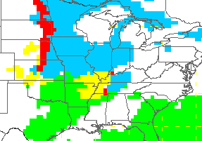
We will keep a close eye on that because we do have a frozen ground. Anything that doesn’t fall as light snow could cause some icing. Thankfully, this looks rather light.
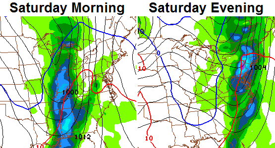
Friday turns milder with readings working well into the 40s. This ugly pattern throws another system at us late Friday night into Saturday. This will send temps a few degrees warmer for Saturday and should give us a nice little drink of water…
The air behind that doesn’t look very cold, but it could be just cold enough for some flakes behind the front. This is a pattern that will throw a weak system our way every day or two. Each of these will likely take on a more wintry look than the one before it.
The air behind these gets colder and that leads us back into a pattern that brings wintry systems our way. The Canadian Model is excited about the middle of next week…
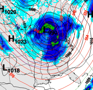
The pattern just after that is going to head back into a very cold one and one that is likely to produce a lot more snow around here. I will have more on the flip back to winter later today. Enjoy it and take care.

17 degrees warmer than this time yesterday in Lawrenceburg. From -7 to +10. If that keeps up for the afternoon we should hit close to 30 today.
I think we’re getting used to the cold. 13 degrees on wake up for me this morning, a month ago, I would have been like “where’s the wool coat?” This morning it was, “yeah double digits! Short sleeves or not?”
WOW…Blowtorch…
How did the Canadian Model do on the last event?
Based on early gridded verification, the Euro and Canadian identified the winter weather threat prior to the GFS latching on. However, both the Euro and Candian slowly adjusted westward and warmer as the event came closer. The NAM clearly did well with the low-level temperature and precipitation forecast (about 24-30 hours prior to the event). GFS caught on to the NAM, but by the time the GFS was getting right, the storm was already here. As I’ve have stated before, the Euro usually gives you the heads up but is not that good once the storm is about 72 hours out. GFS tends to do well with storms in the 36-72 hour time frame. NAM has consistently verified better within 24-30 hours.
All of the models are usually to fast in the long term. This is why you see them correcting themselves as the storm gets closer and this is why you usually see the northward or more northwestward shifts in their solutions.
So in other words we need the long range models to show a storm several hundred miles south of ky that way the northwest shift as the storm approaches will keep us in the snow?
Thanks Chris! I might be able to go to work without long johns for a day or two! May have to trade them for galoshes! 😉
Our parking lot at work is not nearly the skating rink it was yesterday, and with some sunshine, it can only get better, hopefully.
Everyone have a great day and stay warm! Be safe out there!
Thanks again Chris for the updates.
I will not get my hopes up…
I will not get my hopes up…
I will not get my hopes up…
dangit… I got my hopes up 🙁
Funny!!! sorry but again, same story line, gets cold yes for 2 days, then rain, temps climb into the 50’s!!! front goes by, few flakes, no big deal (At least in Richmond!!!) Nobody has to correct me because the actual weather is the truth! It has been doing this for a long time!
However, if the statement “likely to produce a lot more snow around here” = a trace to 1 inch, then ok, I think that probably is correct, but of course after the low goes by with the rain.
Same story….Just like my Bengals!
True – BUT………..The O N L Y difference in that trend is the brutal temps we just had…….that has NOT been the trend since the 90s. Quite the opposite………..So who knows, that could be a hint of something changing in the trend……….
Just like the bengals going to the playoffs, yes three years in a row, but cant win one! Haven’t since the 1990!
Yes, it got cold, but the southwest trend of the lows continue to be the key! Trend, I’m starting to dislike that word. But its the truth!
Touche’
But trend doesn’t mean constant.
Arrogant much, BengalFan?
I notice some people mention how (in early Jan), the sun is getting higher, days are numbered for winter, etc.
So basically for them, Winter is pretty much over after Christmas? MmmKKK
The coldest/warmest temperatures are about 1-2 months after the winter/summer solstices. There is always a lag. Sun angles become more of an issue in like late Feb/March.
That’s like saying summer is almost over after the summer solstice in June–when July and August are always hotter.
That is an excellent point.
We’ve already reached our lowest average high temperature. The average high will begin climbing within a couple of weeks, so in many respects winters’ days are numbered.
The average high by the end of February is 50 degrees in Lexington. If we don’t get a good snow in the next several weeks, then our best window is gone.
We’ve been looking for storms in November, December, and January. We are rapidly approaching the warming side of winter. Hopefully we get a good snow soon.
For Kentucky, the best snows do not occur in November or December. Anyone who has lived here long enough knows that. Our best snows usually occur from late January into early or mid-March.
You can’t just go by “average” temperature for the year. It doesn’t mean you have missed anything just because the “average” high starts to slowly climb toward spring.
For the ones that give up easily, some of the biggest storms and snows in my life have happened in March with the storm of the century and April 1987 when we measured 36″ of snow. Someone commented they don’t want a snow then because they melt in two days, well these didn’t, so don’t bail out of the ship when the trip just started.
I totally agree!!!
However the ship that we are on keeps making the same trip over and over and over and over, riding the southwest winds to Rain / backend snow( inch at best–at least here in Richmond).
But yes, I do like thinking of trips that we USED to have in Feb, March and even in April!
36 inches of snow? Your not from around here ( central ky) are you.
Dorton in Pike County and yes w measured the snow with a yard stick.
we
Even the higher elevations of northern Alabama got, IIRC, around nine inches of snow from this remarkable April 3, 1987 event. In fact, Birmingham received their latest measurable snow on record and it’s still known today as “The Dogwood Snow”.
To show how much wx can vary in our part of the world, this April 3 1987 snow storm happened on the anniversary of the April 3 1974 “Super Outbreak” that left over 300 fatalities from Alabama to Canada. Kentucky had over 70 deaths, including 31 in and near Brandenburg from an F5 tornado.
Anyone noticing the snow developing on radar today? Reaching the ground??? Clipper trying to do something here? Any info about this?
Probably not reaching the ground. Temps have remained around 30 here in Versailles. Hopefully we can get a little burst of snow tonight that would stick. Probably just wishful thinking.
Maybe something to keep our eye….
http://i.imgur.com/oKze5tw.jpg
will lead to bigtime rain!
No
No know about rain but I’ll take that any day of the week and run with it..That’s the type of setup for Old School as rolo would say..
Looks like that phasing might actually occur in a spot to give KY a good snowfall. Not that I trust anything 10 days out, but still–fits the pattern and the call for another arctic outbreak around 1/20.
Get this nasty stuff outta here. Ready for spring
I for one could care less about 0 weather snow ok but heck
With 0. Good site Chris. But they sure are a lot of pipers
On here that just gripe. they know half as much as
You do an still think they know it all. Keep up the good
Work on KYT and this site.
The snow poor megalopolis in CKY should probably expect to see a lot of OPS this winter.
Other People’s Snow
Just sayin’.
Bubba–I’m in Central Kentucky and had 30 inches in 2009-2010 including snow on the ground most of January/February. I think you need to say you poor folks East/South of the River 🙂 My “poorest” snow season in the past five years has been 11 inches, and that was 2011-2012.
In my world – Richmond – we have not had more than 9 inches of snow total in an winter in the 9 years I have lived hear and never more than 5 inches at any one time. Crazy local weather…
thanks for the update, Chris!
thanks to Chris Mercer for the always cool stats and to Ready4Snow for something to look for SNOW wise- good, good stuff.
felt downright pleasant out and about today…
No amount of “bring on spring” changes anything.
Verga moving into western KY??
Chasing the Big Snow. A new book based on peoples desperate needs to see any type of snowfall.
…been busy with my ruler… 1.5 inches of snow and counting for the year, for my part of Richmond anyway. What’s your total? Who’s got the most? The least?
17.5″ here in Northern KY for the season. 🙂