Good Wednesday, evening. Breaking News… temps hit the freezing mark across many areas of the state today. Anyone else ready to fire up the grill?? 🙂 The mild up isn’t going to be the greatest in the world and isn’t going to last very long.
It’s actually coming with a bit of a price as some light snow is cranking ahead of it this evening across western Kentucky. Here’s regional radar…

A light wintry wintry mix is possible across the state on Thursday. This will be on the cusp of a bigger warm up for Friday and early Saturday. Temps will approach 50 in some areas by Friday and early Saturday. That won’t last long as a cold front works across the state on Saturday.
That front means widespread rain and gusty winds for Saturday as temps drop quickly from west to east. We could even see a passing flake into early Sunday.
A system early next week is trying to take on more of a wintry look on many of the models. The European Model is among them…
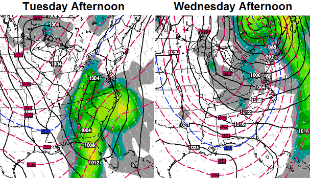 That’s a nice shot of cold that comes in behind that system and shows how wimpy this mild up is shaping up to be. The real deal cold looks to return next weekend into the following week.
Take care.

Thanks Chris. Now, GO CATS!!!!!
C A T S…..CATS CATS CATS!!!
I need next Friday to be nice, i have Luke Bryan tickets,after that who cares lol
Pffft
NWS Memphis has a Winter Weather Advisory out for its coverage area, including western TN. Not that much expected, but unfortunately a little freezing rain could mix in with the snow. Indeed, Little Rock is seeing freezing rain now.
Light snow currently being reported at Cape Girardeau MO as well as at Paducah.
Pffft
Just saw the weather ad on Wkyt that directly compared Bailey’s forecast of this now-departed arctic blast to the voice of reason himself. Can’t say I’ve ever seen that kind of ad on TV before…wow.
I saw it to, definitely ballsy, but risky too. Could definitely bite them later, its impossible to 100% predicting the weather.
“be” …Pffft 🙂
Nobody said anything about 100%
Guess I’m just thinking of a possibility that wkyt could be wrong and it could make them look bad
I will say that the “voice of reason’s” news channel had the forecast for this past Monday set at a high of above 30 and a low in the 20’s until FRIDAY (three days before) it hit -25 wind chill when every other station had it at single and negative digits well over a week in advance. Talk about waiting until the last minute to pull the plug 😉
I saw that too! I think that was a bit over the top. I’m not into bashing other folks. Actually made me lose some respect for WKYT.
I disagree with you. For too long we have had to listen to Bill Meck spew irrational nonsense about WKYT. I say GOOD JOB!
In a mood Andy?? Lol
Pffffttt
LoL one to many pffts there my bad 😉
Any of the stuff on radar around Louisville hitting the ground?
Check out the Ice *volcano” pic and video of Yahoo Falls in Southern KY. I wish I knew how to post picture on here.
http://www.Facebook.com/visit.mccreary