Good Thursday, everyone. We are tracking a bit of a wintry mix across parts of Kentucky today. This mess is on the leading edge of some milder air that moves in for the next couple of days. This is part of a short-lived mild up that is on the ugly side with clouds and showers.
The action we see coming in today will feature some light rain, light snow and a touch of sleet. The highest threat for that mix will be in the west, north and central areas. My concern is that we have a frozen ground and road temps that are well below freezing. Even with air temps that go above freezing… we need to keep a close eye on the possibility of a slick spot or two developing.
Here are some tracking tools…

Current temperatures

Winds

I-75 @ Winchester Road Lexington

I-75 @ Iron Works Pike Lexington

I-75 @ Clays Ferry Bridge South Between Lexington and Richmond 
US 60 @ US 127 Frankfort

US 127 @ Frankfort Frankfort

I-75 at MP 36 London

I-71/I-75 at Buttermilk Pike Near Covington

I-64 @ 3rd St. Exit Louisville

Downtown Louisville @ 2nd & Broadway Louisville

I-65 @ 234 Near Bowling Green

I-24 MP 4 @ US 60 Paducah

Milder air pushes in for Friday as thermometers head toward 50 in some areas. This will be ahead of another system that rolls eastward on Saturday, bringing showers an gusty winds to the region. The models are a little faster with this than before and that means we try to dry it out a bit by the end of the day. That’s when temps fall a bit.
From there… we watch another cold front drop into the region by late Monday and Tuesday. Several models are developing a wave of low pressure along this front to our east…
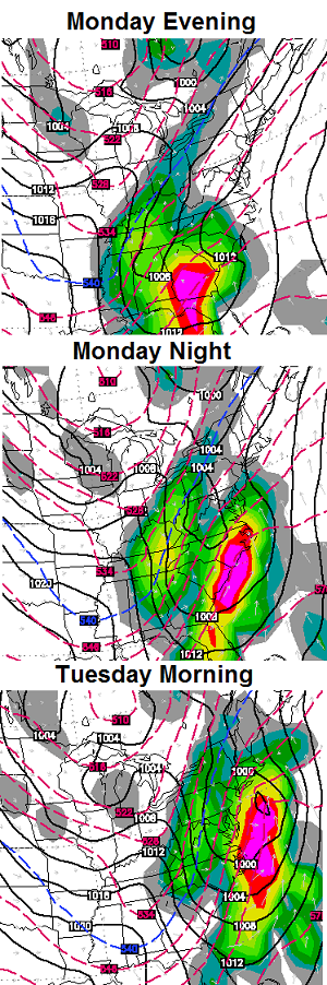
That’s the Canadian Model that looks a lot like recent runs of the European Model with that system. The European Ensembles are showing a fairly healthy trough digging in during the same time…
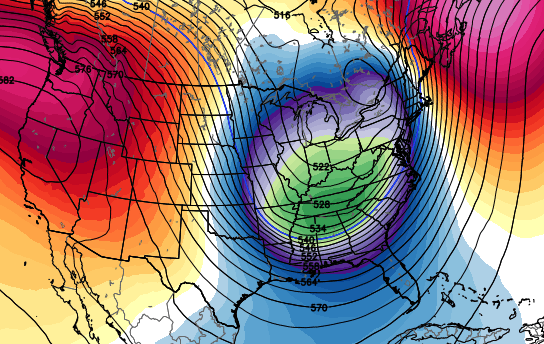 The pattern is loaded with “diggers” that try to become something bigger as we get closer. More on all that later today.
Have a good one and take care.

Nice snow surprise. Have more snow out of this than the Sunday “storm” that didn’t produce anything in Louisville.
I know this isn’t weather related, but i’m curious how the UL fans felt about rehiring Petrino; I for one couldn’t understand why he left in the first place – he had everything going for him and possibly been a national title game by now, but can’t change the past; I am glad to see it, always thought he was the perfect fit for the Cards – hope he hires Brian Brohm for Qback coach.
As a WKU grad, my guess is that WKU officials are breathing a sigh of relief that Petrino’s “extra baggage” may end up staying closed during his short stay in Bowling Green. Seems WKU was rolling the dice; hire an excellent coach (at least in football) and hope he will be gone before doing much damage off the gridiron.
As a side note here in Nashville, Vandy’s James Franklin has apparently agreed to accept the Penn State head coaching job.
I wanted Narduzzi from Michigan State. How many chances does Petrino deserve? He left UL for the NFL. He left the Falcons before the season was even over because he was a coward. Went to Arkansas and slept with horse faced women. Got a job at WKU. Now he is back at UL I hear everyone say it’s his second chance,more like fifth chance.
Dihard Cards fan here!!!! I would not have chosen Petrino from an ethical and moral standpoint he should not be coaching anywhere….But for the Football coach in him he is one of the best out there on the offese of side of the ball. Just hope he walks the straight and narrow. I am not one for kicking you when your down, but on the second thought is he a freaking cat with nine lives. Sure seems that way.
Oh yeah!!! THINK SNOW actually it is snowing…
I have very DEEP concerns and will echo the sentiments of others when I say I hope his personality does not create a weight that implodes his desirability as a football coach. He has some ‘healing’ to do when it comes to how he treats those around him. I am VERY surprised by the hire and fear that the friendship between U of L’s AD and Petrino may have clouded judgement. We will see….its just football, its not like its WEATHER! 😉
Looks like we are going to get to at least mid-January and still no decent snowfall for the majority of Kentucky. Maybe the streak will be broken, but outside of the north, this has been below average for many.
Bigger diggers are better wetter…
Wetter equals flooding rains 😉 No thanks have had a couple of those this season 😛
just yesterday you said that the trend would hopefully change,,,,no rain…but the TRUTH is real…Southwest lows bring rain..no snow!!!!!!
my post consisted of 3 letters yesterday the p the f and the t and there was multiple Fs and Ts
you read an awful lot into that LoL 😉
If they dig big, they hold cold… 🙂
And being from Laurel Co(now living in Sevier Co TN tho), I’m very familar with how easily it floods down you’re way. I totally understand ’bout not wanting anymore rain.
0.4″ at my house in Valley Station
Was not expecting anything last night according to one of local Mets I listen to.
No problems other than the subdivision roads were surprisingly slick at times.
I hate two completely different forecasts for same day! The forecast above for Saturday says,
“This will be ahead of another system that rolls eastward on Saturday, bringing showers an gusty winds to the region.”
NWS says:
“Partly sunny, with a high near 53. West wind 10 to 14 mph, with gusts as high as 20 mph.”
Should I flip a coin? 🙂
I gave it a second look and I guess Chris is referring to the east end of the state as ‘the region’, cause that forecast is for the Purchase area. Looks like it will be out of here by Saturday morning, but hang around the eastern side of the state.
Reading the NWS page today about records, and it says January 9 in 1978 Louisville started a 49 straight days stretch with atleast .50 inch of snow on the ground! WOW! The good ole days!
How would anyone like to experience these kind of temps?
Day 1: High -3, Low -15
Day 2: High 0, Low -17
Day 3: High 1, Low -4
Day 4: High 2, Low -12
Day 5: High 2, Low -20
That was what happened in Lexington from February 9-13, 1899. Now that is a cold sanp!
Scary cold, power failure with that kind of stuff could be deadly!
I’m sure most people made it fine in 1899 just have to be prepared.
Most homes if not all back then had fireplaces, that’s not the case today!
agreed but they have kerosene and Propane heaters to replace fireplaces and can be put in any home 😉 just saying
Here is an interesting read
http://patriotpost.us/opinion/22623
Great reading. Thanks Andy.
Winter can still rule in March (after all–spring begins March 21). Check out the stats from March of 1960. Lexington had 3 inches or more of snow on the ground from March 3-18. I think a 15 day period of that much snow on the ground would satisfy most snow lovers. The total peaked at a foot on March 10. There was even an inch left on March 22. So almost the entire month had snow on the ground.
Must have been very cold with the high sun angel at that time of year.
It’s noteworthy that even more southernly cities have had their biggest single storm snows in March. As examples, take Nashville and Memphis (March 17 1892 for both cities, about a foot and a half) and even Birmingham (about a foot of wind-driven snow during the infamous March 13 1993 blizzard).
Super storm march 1993 is a great memory for folks from Lexington and to the south and east!
Not so much to the west of that, Frankfort got about 2 inches and I remember being so disappointed how we missed such a historic huge snow storm!
I was a kid in Morristown TN at the time. An incredible experience for my family and I to say the least! All of us huddled around the rarely used fireplace for light and warmth until power was restored. Snow drifts nearly up to window level on some houses. One of the strangest sights was a neighbor’s garage with several inches of snow INSIDE the garage despite main garage door being closed, but there was a gap of just a few millimeters on the floor that still allowed the wind driven snow to pile up inside!
I lived in Morristown at that time also. That’s a storm I’ll never forget. Nearly 22″!!! The years prior that storm always produced at least one snowfall of 5-8″ (sometimes more) every year. We were used to getting snows then and it was great, but since that storm there has been a near complete snow drought. 2-3″ seems to be a big deal now. Seems as though that was a turning point for our winter weather. Really depressing as a snow lover.
Reports of sleet in southern Kentucky and even as far south as Murfreesboro TN.
I stepped outside a while ago; only a very light rain at this time near Nashville, but my work colleagues said there was some sleet earlier (unfortunately, I have an interior office here at work).
Local met here in charleston pulled a line from CB and said he guarantees a big snow for our area before this winter is over. He’s usually a pretty reserved met so I wonder what they all see that makes them feel this way?
I dont’ remember Chris guaranteeing anything ?
A few flakes of snow starting to fall in Frankfort!
This is one of the first times I’ve seen temperatures drop as a system moves in from the south/southwest. Is freezing rain/snow a growing concern as the system moves into eastern Kentucky overnight?
It was pouring sleet around 2:20-2:30 pm in downtown Nashville today but nothing stuck.
On a separate note, I really hope signs of blocking emerge soon. This +PNA is in vain without a really -AO/-NAO.
Sleet bounces 😉
Yea, the -AO/-NAO helped bring that white Christmas in 2010 for places like Nashville, Huntsville, etc.
BTW, I’m also in Nashville.
Surprised CBs station are doing smack talk ads on TV about how he got the cold air forecast a week out while others were a lot warmer. I’m sensing some Brick Tammler rebuttals and some Anchorman style street fights. Yeah baby! 🙂
Brick Tamland.
I was surprised by that as well. I think people should just make up their mind as to who is more reliable with the forecast. I think CB is more right than wrong, but I am certain there have been times “the voice of reason” nailed the forecast as well.
Well, this man is NOT amused and he IS brick Tamland:
http://www.youtube.com/watch?v=MpM_RS-7dGY
34 in Lawrenceburg with a mix of sleet and snow. I wonder if the surface temps are still cold enough for something to stick?
Really big flakes are falling here and the roads are turning white.
Deck dusting of sleet and snow in Frankfort temp 34!
I have more snow from this then I did from the “winter weather advisory” and “wall of snow” when the arctic front blew through the other day. At least there is still a bunch of salt on the roads.
Lot of salt, but no snow. We have literally not had 10″ of total snow combined now for the last two full winters, plus this one so far.
Frankfort had about 6 inches of snow by this time last year during a very mild winter, about 3 this year, so cold has been around this year but snow results are very weak!