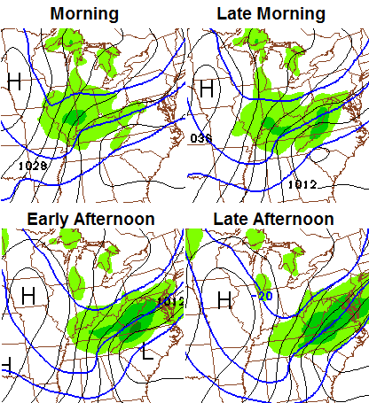
Good Monday, everyone. The potential for accumulating snow on Tuesday is on the increase as a wave of low pressure develops along our arctic front. This sets the stage for a harsh period of winter weather across much of the eastern half of the country.
The trend among the models has been for a strong wave of low pressure to develop along this front. That is even being depicted well by the NAM and GFS…
NAM
GFS 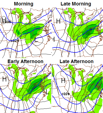
The Canadian Model is also on board and is a bit snowier…
Cutting straight to the chase… the models are showing the potential for widespread 1″-3″ snows with more in the east and southeast. That “more” in the east could push storm criteria of 4″ or more. If the models continue this trend later today… then an upgrade may be needed.
Again… those are the model depictions, but we are now within 24 hours of this event and the trend is for a bigger system. BTW… this is NOT a clipper. It’s a storm developing along the arctic boundary.
I will have more on this around noon.
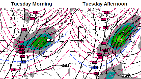
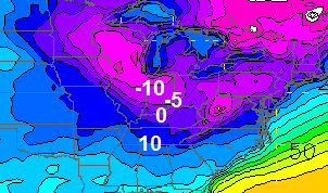
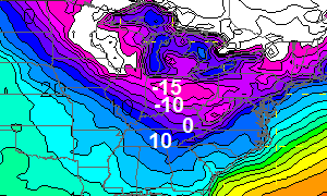
Some serious cold comes in behind that as temps drop into the low and mid teens by late Tuesday afternoon. Readings may hit the single digits or flirt with 0 by Wednesday morning. Check out the GFS numbers…
Another system dives in from the northwest on Thursday and may have a band of light snow with that. The GFS takes temps toward 0 and below behind it Friday morning…
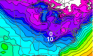
 The Polar Vortex is likely to take another run toward the United States early next week. This is likely to send a shot of even colder air our way. Look at the temperature departures for Monday on the GFS…
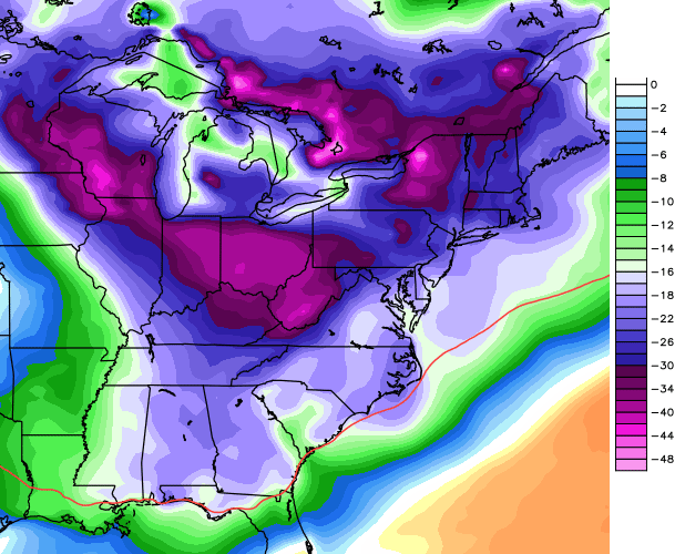
Here’s what that looks like with the temperature forecast for Monday morning…
I will update things by early afternoon. Have a good day and take care.

Woooohoooo!!! So what your say in’s there’s a chance… (movie line)?
Thanks Chris for your dedication! The weather today was awesome! Got a good hike in with my family today!
Dumb and dumber lol. Love that movie. I myself am ready for spring thunderstorms 🙂
“Just when I thought you couldn’t possibly be any dumber, you go and do something like this… and totally redeem yourself!”
I’ll take 3 inches of snow CB. Beats clipper systems.
http://www.weather.com/maps/activity/travel/usweatherday9_large.html?clip=undefined®ion=undefined&collection=localwxforecast&presname=undefined
Fail for posting TWC link
I was thinking the samething!
That is for Tuesday, January 28th???
http://www.weather.com/maps/maptype/tendayforecastusnational/usweathernight8_large.html?clip=undefined®ion=undefined&collection=localwxforecast&presname=undefined
Looks like my afternoon drive to Columbus should be fun.
06z NAM
http://mag.ncep.noaa.gov/Image.php?fhr=033&image=data%2Fnam%2F06%2Fnam_namer_033_850_temp_mslp_precip.gif&model=nam&area=namer¶m=850_temp_mslp_precip&group=Model+Guidance&imageSize=M
http://mag.ncep.noaa.gov/Image.php?image=data%2Fnam%2F06%2Fnam_namer_036_850_temp_mslp_precip.gif&model=nam&area=namer&storm=&cycle=06¶m=850_temp_mslp_precip&fhr=036&group=Model+Guidance&imageSize=M&scrollx=0&scrolly=0
http://mag.ncep.noaa.gov/Image.php?image=data%2Fnam%2F06%2Fnam_namer_039_850_temp_mslp_precip.gif&model=nam&area=namer&storm=&cycle=06¶m=850_temp_mslp_precip&fhr=039&group=Model+Guidance&imageSize=M&scrollx=0&scrolly=0
Thanks Chris. Won’t need the long johns today but sounds like long john weather the rest if the week for sure! Brrr! Have a great Monday everyone.
Jackson NWS not at all impressed, going with a broad range of 1″ snowfall totals.
Do you blame them after the last faiil by everybody?
Not all. Major issue, once again, will be dry air to overcome.
Their new map they just posted has 1-2″ ranges from London to Whitesburg on north of their coverage area. They said in the discussion they were going to let the day shift guys analyze the 12z models before making a decision on any advisories.
Not unimpressed, just using precaution. However, as Chris stated, this is not a clipper.
For the past 3-4 years Jackson has been spot on for my area.
If we don’t get any southern stream storms to cooperate over the next 5-6 weeks, this could be much of KY’s best chance to get a decent snow this season.
Euro last night had a closed low in texas around day 10…Ten days out but you never know..Both GFS and Euro are pointing to something in the long range..At least there showing possibilities..Better than nothing..
If the large upper trough does indeed develop over the eastern US, which it looks like it will, then the southern stream will be crushed. We will have the cold here in place, but our snow will be from these small clipper type systems…and that is what a LOT of the long term models are showing.
Anybody notice that the link for the blog update in Chris’s twitter has the word duno in it lol 😉
This one may be in the Goldilocks Zone. It appears to have enough cold air things in KY could be interesting, but at the same time it isn’t far enough south for the NWS Jacksonville, FL to be forecasting significant rain chances for at least the southern part of their coverage.
great! thanks, Chris-safe travels.
something cool to track- I like it.
think SNOW
Thanks Chris,have a very safe Trip and post us some pics of snow.
Weather person on another site said this was another clipper coming.
NWS LMK calls it a Saskatchewan Screamer.
If it yields more than a couple of inches, I’ll scream.
Nam continues to show a little kindness to Eastern Ky..If you consider a few inches of snow kindness…Just hope the moisture is there..Not dried bones like the last..
Two things stand out: Warm air today (and it’s pretty warm down this way, and dry air. I think this will undercut totals in a big way. So, 1″ amounts being projected by the NWS seems to be a good bet.
go with the theme of the winter <1 inch 😉
No big deal for the Louisville area. However I did run by my salt supplier and picked up another 1/2 ton. Rock salt is running thin and had to make sure I have it just in case we get some wintery precip. Should throw a few hundred pounds this evening. With the cold air moving further south our chances of big snow is slim to none. Southeast ridge will be showing up again mid February so we will go from plain cold and dry back to cold rain. Yippee!!!!!! Just what KY needs!
Good planning on your part with regards to your salt buying. 🙂
Yes, I saw that Winter Storm Watches are up for locations from the Appalachians east. Eastern KY could reach Watch criteria.
Even though this may become a storm event, I’m still going to review the RAP short term model as it performed well during the last clipper. But now, it may be wise to take one more look at the most recent run of the NAM (12z), which I haven’t done yet. The 06z NAM spit out about 1.7″ for Louisville on average.
And just like that…NWS Charleston WV issues Winter Storm Warning for northeast KY and other portions of its CWA for 3-5″ snow. Just issued about 15 minutes ago.
Northeast ky is under wwa while wv is under wsw
Yeah, I noticed the map. Their Warning product included northeast KY in its text for some reason. Nevertheless, I would not be surprised if that part of Kentucky is upgraded to warning status in future analyses.
no, the winter storm warning is for West Virginia. However, in their discussion they stated they wouldn’t be surprised to see snow totals increase!
Not one of the 1-3″ forecasts have panned out thus far this season in Lex. Highest snow so far has been 0.8″ I just would like to at least get a couple of inches. Last year there were four 2″+ snow events, heck, even the winter before featured a 5″+ unexpected winter storm in March, so that makes me feel ok that theres still time, its just running out quickly once we get into mid- February.
I’m with ya, Frankfort largest snow was last Friday close to 1.5 inches in my yard, a 2-3 inch snow with cold air coming in would atleast give the Kiddos a few good sledding days!
Latest GFS has our little wave getting ever so slightly stronger..Northeast looking good..
🙁
Dodger is hoping for a nice snow but realizes these things don’t often go as planned. Dodger keeps “snow hopes” in check!
Jackson NWS is now backing way off snow until tomorrow evening, so my question is, what are the other offices seeing that Jackson is not?
Um, no they did not. Their last update said they adjusting their forecast to start the snow later tonight (late Monday night and early Tuesday morning).
Thanks MJ here is hoping we can crack the 2 inch mark for the season in Knox. So far outside of 1 cold snap this winter has been hoe hum around here.
Two things I am seeing: 1.) Mild air currently in place. 2.) Fairly low relative humidity.
This is starting to look like another Kentucky snow bust in which amounts are small if any.
Easy there, dude.
People are so quick to run their mouth…thanks for all you do Chris, looks like greenup could see a decent snow!
Not a clipper, but a storm. In my humble opinion this is when we will get a decent snow…when we were least expecting it!
The National Weather Service has Grayson looking at 2-4″ of snow and Chris Bailey has 2-6″. Using my ham plant dome fartometer, I converted measurements and found that we are expecting approximately 2-6 snowflakes.–said my wife.
The National Weather Service has Grayson looking at 2-4″ of snow and Chris Bailey has 2-6″. Using my ham plant dome fartometer, I converted measurements and found that we are expecting approximately 2-6 snowflakes.–said my wife.
Sorry about the double post. My wife says I need to explain. The Ham packing plant in Grayson emits a great deal of smelly air pollution that we believe heats the atmosphere resulting in much less snowfall than predicted for our area. It seems that most systems split and go north and south of Grayson almost every time.