Good Sunday evening, gang. Your friendly weather dude has had a busy day and am just now getting around to updating. This post is about the arctic front that drives in here Monday night and Tuesday. This is likely to spawn a wave of low pressure along it and could bring snow to much of the region.
The NAM for Tuesday…
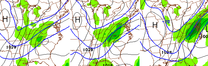
The European Model… 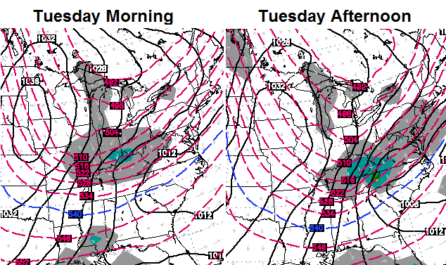
The Canadian Model…
The arctic temps will have bring a serious fluff factor to whatever snows fall. Want to know why this one will work out and become a nice snow maker? Because I will be out of town for much of the coming week. No worries… Minneapolis has lots of snow and bitterly cold air, so I won’t be shut out. 🙂
Have a good one and take care.

Thanks Chris! Don’t forget us while you are gone. Have a great trip!
Thanks Chris, maybe some real snow will follow you back home 🙂
You haven’t been shut out yet this season I don’t’ see why things would change 😉
Funny, Chris 🙂 Any thoughts on timing? Will this be an overnight snow or Tuesday morning? Basically, will we possibly be out of school all day Tuesday or could it be more an early release situation? I know you can’t nail down the moment of arrival, but just looking for a ball park time line.
If they didn’t get the last snowfall correct as it wasn’t happening, how in the world do you expect them to get one right next week? And a better question….since we’ve received about 1 inch total so far this year, why would you believe it’s going to snow at all next Tuesday? I’ve got to see snow falling, sticking & not melting by morning before I believe it.
BPS
Yet you keep coming back for the forecast?
lol Get ’em! Down with the haters!
BURN!
Chris please tell me that you will keep us updated we can’t get alone without you this week
How’s that forecast of yours telling everyone that we wouldn’t get below the teens during the polar vortex? Great call on that one. lol
Oh, yeah, buddy…go where there’s snow and leave us starved souls down here…. j/k! 🙂 Enjoy your trip!
Please bring us some snow back with you,but leave those frigid temps up there..lol Have a nice trip!
Have a good trip Chris…and maybe bring a big big snow back home to Kentucky???? 🙂
The 00z NAM is a bit stronger with the clipper tomorrow night into Tuesday Morning.
Stay warm! You will keep us updated, right?
Models continue trending in developing a decent storm Tuesday Morning, eastern Ky in the game now for several inches, waiting for 00Z GFS
Ugh, depending on a clipper is depressing. Dodger says let’s get the southern jet fired up and ready for takeoff before it warms up! Dodger!
Hello Chris. Just wanted to drop by and say, have a very great time on your trip. And, a safe one too. Chow for now.
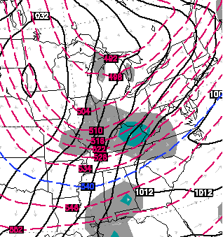
00z GFS Snowfall
http://wxcaster.com/gis-gfs-snow-overlays.php3?STATIONID=RLX
Have a great trip Chris and enjoy the snow up there.
this is one them SUPROISE possibilities for SE/E KY as this could be even bigger than Bailey sees. this is going be a RAPIDLY strengthing sytem and if it slows down little SE/E KY could get a WSWARNINGissued. u in central ky on back u might get snow as well but this mainly a SE/E KY snow.
4-8 for LONDON west