Good Sunday to one and all. The clipper that worked through here last night turned into a wimpy one. While areas across the north picked up around an inch… that was about all she wrote across Kentucky. The dry air proved to be a killer. Now we turn our attention to a frigid week ahead as arctic fronts sweep in from the northwest.
Let’s talk about what happens today before looking at the upcoming week. We start with some slurries and snow showers across the east. That action scoots on out of here and leaves with a nice afternoon. Winds will gust up as the sun returns.
Those same gusty winds will blow colder air in here late Monday as the first arctic front approaches from the northwest. This will bring rounds of light snow with it into Tuesday…
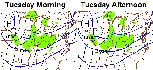
Temps on Tuesday will drop into the mid and upper teens. Gusty winds will make it feel closer to zero at times. Single digit lows will be possible by Wednesday.
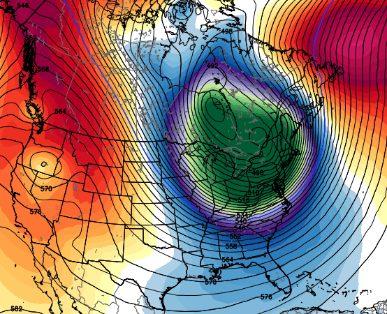
All of this is part of a pattern that will feature several systems diving in from the northwest through the week and into next weekend…

The core of the bitterly cold air looks to stay just to our north during the week, but we stay plenty cold enough. Highs in the teens will be noted on a few days and lows could drop close to 0 on a night or two.
Those impulses dropping in will each bring snow chances our way. Timing those is always the key, but it looks like they arrive on Tuesday, Wednesday night and again during the weekend.
Watch the one over the weekend as it has the best chance to develop into a full blown storm across the eastern part of the country. That one is also likely to tug the polar vortex back into the northern part of the country early next week…
I will have an update later in the day. Make it a good one and take care.

chris bailey, this comment is in no way intended to bash you or make fun of you but some times we lose 1 and some times we win 1 but the best part i like about you when you miss a forecast is you admit it and you try to find a way to explain it which you have done so but i do have 1 problem and that is you, my friend are way too quick to bash other nws offices if they don’t go the way you are forecasting or the way you are seeing it play out. last night the nws in charleston, ( which i think just down right stinks) did not have a wwa out for 2 counties in ky and you made the comment that you would like to see them explain that to the public…….could it be that the nws in charleston actually sniffed the dry air out and knew that the blob of snow showing up on radar in western ky. would all but fizzle on its way eastward and that is why they had no wwa out for the far eastern ky…….no matter how good i am at something, there is always room for improvement…….you are by far second to no one the best met. out there and you are the 1st 1 i go to for all my weather needs…….thank you for allowing me the time to talk to you and please, every one out there in blogging land….this is not a bashing so no rude comments please…..god bless and make it a blessed day.
You ever think about emailing CB privately instead of “constructively” critisizing him on an open forum? It would be more discrete and have the same effect you are looking for. This isn’t meant in any way to be critical towards you To ney.
*Toney
i wasn’t bashing him…i made that clear and i wasn’t critizsisining , ( i know i spelled that wrong) him, i was only pointing out to him something i did not agree with just like he did on the open forum by bashing the nws, which i do all the time but sometimes the nws is right and more times than not they are wrong but i am sorry if i offended any one at all but i think i will just stop posting period because it is getting to where you can’t even state your own opinion on here unless you are being watched…i have always followed mr. baileys blog since the beginning and i will always follow it but i promise this is my last comment cause i knew when i posted that comment this morning, despite my best pleas, i knew someone would take it the wrong way…..best regards!!
They were right but I would side with the trend and say that was luck that the dry air ate the snow. They (that specific NWS office) appears pretty bad from seeing there advisories and hearing from people in their coverage area.
Sorry Toney. I apologize for being critical. After rereading your post I can see I misinterpreted it. I promise I will quit worrying about being the internet police.
Not only did it not snow it actually rained sometime overnite
No, no, no, here’s the 24HR forecast from yesterday through this morning.
http://i.imgur.com/KIafVI1.jpg?1
Obviously, the temps never reached high enough yesterday evening and overnight to rain. Don’t look at that evil Mesonet either, it just spreads temperature lies!
Thanks for the sarcasm
Well, this is a weather oddity. It is colder in parts of Central Florida this morning that in Central Kentucky–even with snow on the ground in Central Kentucky. One of my friends told me it is 30 in Port St. John, Florida–and it is 32 right now in Lawrenceburg.
On another note, we are just past the midpoint of winter. We are near normal in temps (around 1 degree below to just at normal) and above normal in snowfall in the northern half of the state (excluding Lexington) and below normal in the southern half of the state.
Another next weekend storm somewhere in the east and all we get is cold air. Give me one 10 incher and 40’s the rest of the season instead of these “potential” snowmakers that is a dud and cold air.
As long as the snow would last more than a couple of days I could agree with your logic 100%.
From the Louisville NWS @ 3:10 am
Our uneventful clipper system is quickly tracking east. Guidance 24
hours ago was in good agreement that 1-2 inches of snow was likely
across portions of the forecast area, thus warranting the issuance
of a Winter Weather Advisory. The rather poor job of numerical
guidance handling the dry lower atmosphere, the warm-air advection
ahead of the surface low, and certainly my interpretation of this
data and past trends this winter did not produce a good forecast.
Very refreshing to read, that met should be applauded for his honesty and owning his mistake and not blaming just the models. Let’s hope that sort of sentiment becomes contagious.
Guidance about 18 hours out was picked up by the short term Rapid Refresh Model that little or no snow would affect the Louisville area. But, by that time, the numerical models like NAM and GFS had already given the NWS office the decision to put the advisory in place.
It sure did….good call on that post yesterday Mike.
Is my experience unusual? Richmond got no snow in the past week at all and has a total of perhaps 1.5″ for the year. What’s your experience?
Who has had the most snow in Blogland (KY)?
Who’s had the least? Any complete shut outs, anyone without even a deck duster so far?
Same as yours Mike
I have had 5 inches for the season in Lawrenceburg. About “normal” for this point in the season. That has come in about 10 total snowfalls though..so 1/2 inch each average. Largest snow was Friday–about 1.5 inches. Nothing to write home about.
Clippermania!!!!
Yes, Berea reporting in with zero accumulation for the week of clippers.
Believe it or not Mike, NE Louisville has received 10.7″ for the year. Not bad considering most of blogland has been shut down again 🙁
In Flatwoods, KY, I have measured 8 inches of snow so far this winter season. The first event gave us an inch, the second gave us another inch, the third gave us 3 inches, the fourth gave us a surprising 2 inches, and the last two gave us a half inch each. 1+1+3+2+.5+.5= 8 inches.
I’ve read this blog for a while but never posted. Everyone talks about “negative comments”. I’ve yet to read one comment that was targeting Chris Bailey. But several people do question the forecasting. Last night was the prime example. For 1 solid week we heard how the “weekend storm” (which seems to always be forecasted, but doesn’t happen) will be a larger clipper. Well….we got 1 maybe 2 flurries and now our temperatures are almost at 40 degrees this morning. Go figure. Now I read this morning about, you guessed it, “next weekend”. Why should I believe that? Call me a “Debbie Downer” or negative, whatever. The fact is that hyping is not meteorology. One guy on Accuweather has stated for the past 2 weeks to not listen to anyone pumping up a major eastern storm during this pattern because the NAO is still positive and will remain positive for several more weeks. That equals to NO STORM for us folks.
thanks, Chris.
doesn’t look like we got much of anything overnight in Lexington.
that’s the way weather goes…looking forward to some more chances this week and maybe, just maybe we’ll get a good SNOW in here to go with the COLD.
Thanks Chris. Sounds like this week is going to be a cold one for sure! Maybe we can get some snow to go with it! Snow or no snow it’s gonna be interesting. Have a great Sunday all.
What I have noticed with the dry air issue is that the computer models are becoming increasingly poor at factoring it in in regards to precipitation forecasts. This is NOT the fault of the meteorologist, but shows there needs to be improvement at detecting dry air and altering precipitation forecasts accordingly. This shows why school should not be called off a day ahead based on a forecast snowfall that may not come. If it snows, then call off. When I lived in KY, I saw a lot of times school was called off over snowfalls that never materialized.
The mention of cold in Florida is interesting. I live in the same county as Ocala and had 23 F this morning. The birdbaths froze solid. One thing about Florida is that the computer models are very poor at factoring in dry slots in regards to forecasting summer thunderstorm activity. When a dry slot is present, the sky actually changes color here in the summer. If I can actually see a dry slot, shouldn’t there be some way the forecast models could detect them?
Thanks for the update Chris. As much as I would love to see a big snow just as all of you, I’m really to the point that the weekly letdowns has brought me to the place that I would rather it just warm up and stay that way the rest of the season. Not sure what “normal” snowfall thus far would be for my area, but as it stands now here in Middlesboro/Harrogate area, we are somewhere between 3/4″-1″ since October (spread over several dustings)…..a very abysmal amount even for this far south. I just wish for a warm, dry late winter and Spring.
Does it look like we will get a big snow this year in southern KY? Cold seems to be the big story so far. My kids have never seen a snow over a few inches in their lifetime. 🙁 Could this be the year??
this comment is to toney…….chris does a great job with forecasting weather. Sometimes he hits sometimes he misses like all mets and i can see by your comment that u agree. But i will have to say that im almost 100 percent positive that those two counties u speak of were left out of the advisory because they always are. Chris always wonders why they are never in the advisory or are always the last to be put in one. Bottom line is if u keep excluding them form the advisory eventually ur gonna get it right ie clipper.
Carter County wasn’t included in WWA on Friday. Only around an inch fell, but the timing and impact were important. Caused some brief problems on the roadways. NWS in Charleston does a poor job with winter forecasting in the northeast corner. I often wonder why those three counties are included with the Charleston office. I have the same question when it comes to tv programing. I live @ the Carter/Rowan line. I can be in Lexington in well under an hour. Both Huntington and Charleston are farther. I’ve never been to Charleston, and only to Huntington a couple of time (in my 40+ years). Yet, my “local” programing comes from those cities. So, now I grumble with the NWS and The FCC.
i really don’t understand the WWA overall for an inch or 2 of snow ..I think that in itself is wimpy..i know that kinda snow is a big deal anymore around here but I don’t think it constitutes any kind of advisory
I’ve seen widespread accidents when a half inch of snow is on the ground. Sometimes, a winter weather advisory is posted not just for amounts, but timing and impact.
The Charleston Office will hardly ever post a WWA for less than 2″. So when they don’t post a WWA for the NEKY area it’s because they haven’t met advisory criteria which is 2″
But I do think their criteria for the WWA should be revised and should be impact based and not total based!
So CVG is now at 22.4″ of snow for the season, normal is 22.2″. We are now above normal for the whole season in Northern KY.
Can’t say winter is a joke in KY until northern KY is dis-owned. 😉 lol
I disown you 😛
Nothing here in my area of Knott County either. Accuweather is showing us with .78 inches for Tuesday with nothing the rest of the week besides cold air. AW is pretty good on the precipitation side but not temp wise. I believe CB is the best when it comes to forecasting temps. We have had some local meteorologists come in and do career days where I work and all of them say snow is the hardest type of precip to accurately forecast.
I had the double-wammy at my house. Not only did I get no snow, the snow I had melted (over-night). What happened was the polar opposite of what was forecast. Not being critical, just making a friendly obervation :).
could have had rain like the SE folks did then that would have been the triple 😉
Wow, I am really tired of these under-performing clippers. We need the southern jet to get involved somehow, some way with this cold snap. The maps I see in this post are not conducive to any southern moisture. I know some of you will say “oh it’ll just warm up enough to give us rain anyway,” and you might be right. However, I’d much rather have a chance at a big snow than 10 degrees and dry as burnt toast!
The thundersnow of Friday morning will probably be the highlight of the winter in Frankfort, last night proved that models can’t predict snow in this part of the world just a few hours in advance let alone several days!
Snow gods are still lame in this part of the world!
I drove from Versailles to Frankfort Friday afternoon and have to say you guys did a lot better in the snow department than we did.
There’s plenty of cold, but there’s still no sign of any southern stream energy breaking through. That’s why 2010 turned out so well, especially in February. Unless one of these clippers “pops”, it looks like nuisance snows. We have had plenty of moisture when the precipitation has been rain. Go figure, right.
If it snows it snows, it not then no biggie. Enjoy life regardless! 🙂
I always enjoy life , just would enjoy it a whole lot more if we had a big snow. I have 12 year who cannot remember what it is like to sled down a big hill with a decent snow pack.
12 year old child
I’ve got sleds here in the basement for great-nieces & nephews that have more dust on them than we’ve had in snow this year. It’s just pitiful…….they’re in their early teens & haven’t really seen a big snow!
BPS
Not sure why NWS has only 39 degrees as a high for Lexington tomorrow. With ample sunshine and warm air avection from the south, temps should reach at least 45 degrees tomorrow in Lexington.
Just use today as an example, nws forecast high was 33. Already at 36.
The Euro has been on a pretty good system for the 25th-27th time frame. It has had it for a while now. Be something interesting to track over the next week.
GFS has had that system too, then lost it, (which the GFS always does. Has a storm, loses it, then brings it back) So my thoughts are that the GFS will bring the storm system back. The CMC and NAVY models have also been hinting, but are no longer so extreme. Nevertheless, I’m watching……and I’m sure CB is too.
And just for eye candy, hours 312-336 on the 12z GFS are glorious with an apps runner around here. Now we all know that that’s WAYYYYYYY to far out to even mention in the meteorology world….but it’s some nice eye candy.
I’m surprised Chris hasn’t talked about these possibilities unless he’s “afraid” people will take those as gospel and then moan if they don’t work out. And can’t really say I blame him for that. Talking about dustings is getting stale.
Sun seems to be getting stronger, it has did a number on Frankforts snow today!
NWS sounds snake bit after last nights snowless system, their saying the models are showing chances of snow this week, but models are not handling moisture amounts very well!
Sounds like the same ole models we have gotten use to for years around here! UNRELIABLE !
Yesterday marked the point of winter when average highs start their upward trend. It’s been over a decade without a significant snowfall for most of us, and this years snow total has been very small for most of Kentucky. Maybe the dome breaks down, but we are three weeks into January with very little snow. Once mid-February gets here average highs get back into the 50’s. It starts taking the perfect situation to hit for temperatures and moisture to get together once we get to that point in the season. Maybe it happens. Hope so.
I just wish that my grandchildren could experience a snow like the “good old days”. The snow we have had for some time in my area is far below having enough for: making snowmen, building snowforts, sleigh riding, and good old snow ball fights. A skiff just won’t do it!