Good Tuesday afternoon. Looks like much of central and eastern Kentucky is a winter wonderland today. I see numerous reports of 4″ and a couple of 5″ and 6″ amounts. The snow keeps falling and some areas may wind up with a little better than half a foot.
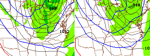
I have been hawking a harsh winter pattern taking shape for the past several weeks. That pattern is here. Bitterly cold temperatures and plenty of snow looks to be the rule for the next few weeks, at least.
Temps tonight will drop close to 0, if not a bit below. Highs Wednesday stay in the teens as another light snow maker dives in by Wednesday night…
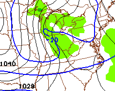
That brings another shot of high winds and bitter temps. Lows Thursday may drop below zero with highs back in the teens.
The next snow maker drops in by late Friday into Saturday…
That’s followed up by a system that may try to ramp up into something more to end the weekend…
 That will usher in even colder temps for next week. Below zero readings should be noted on more than one occasion. Yes…more snow chances will push back in.
This has the potential to be a memorable pattern that’s talked about for years.
Enjoy the cold and snow and take care.

What are the chances FCPS (Fayette County Public Schools) delay or cancel tomorrow based on the weather, road conditions, and forecasted bitterly cold temps?
Based on the precedent they set from just a few weeks ago you would think there would at least be a delay tomorrow.
I am sure they will be on a delay because some roads are horrible.
Fayette schools are closed for WED
I figured they would. A lot of the side roads are bad. Was just out and seen the road crews still out clearing roads.
We can hope it changes and gives some measurable snow to the southern tier of counties.
We can hope. Did you get anything today in Knox, Andy? Nothing but rain with a few flakes mixed in here in Middlesboro……the usual…
We had a covering about 9 but since it has all melted/washed away.
We have an inch or so in London. It’s still coming down pretty steady here.
Maybe in the the next few years we’ll finally get our big snow! I truly don’t believe it’ll be this year though.
Congrats to you folks who did get a nice snow today!
Man, you all have been getting hosed all winter down in Knox county. In London, we’ve literally been on the cutoff of anything decent. I have about 2″ of wet snow on the ground.
I have wet slippery mud here 🙂
It is a winter wonderland here in Lexington! Blowing snow all of the place and C O L D!! Still snowing pretty decently at the moment.
Thanks, Chris. Just wish we had gotten in on some of the beautiful snow everyone is sending pictures of. As usual, Somerset gets the shaft once again…..we get the cold but not the snow. Ah well, props to everyone who IS getting the beautiful white stuff. Maybe before the winter is gone we can get in on some as well. Stay safe and warm out there, everyone and Chris, yo9u be careful up there. They may try to keep you and then we would have to fight them! 😉
London working on around 2 inches so far. Just made the perfect snowman! Will there be more wrap-around to come? Where is the low on radar?
Poor Whitley County didn’t get snow again. I love snow! Why do you think we are in such a bubble from the rest of the state? We used to get lots of snow in the 80’s.
The latest little band pushed our total to 3.3 inches in Lawrenceburg. Still snowing, temp at 19. 8.5 inches for the season now. A far cry from what I had in 2010–but most of that fell in late January and February.
measured about 3″ in east lexington on job site 10 AM. dropped like 8 degrees in less than a hour-chilled to the bone.
looks like 4″ at the office still flurries coming down.
really nice work on this forecast Chris!
here’s hoping we can pile a little on and some of the snow starved like Andy & Coffeelady get a good ‘un soon!
Snowing in Perry county but temps not cooperating maybe an inch accumulation
I live just north of Hazard, and I live on top of a hill. Here at my house, it looks like at least 2 inches or a little more. It’s still snowing, and the trees are beautiful!
Down to 17 now here in Lawrenceburg. Bitter cold wind chills. 3.5 inches of snow. Close to warning criteria, but the winter weather advisory was well warranted. Most media outlets, including “the voice of reason” forecasted this to be a 1-2 inch event. Great job by Chris and LMK for actually forecasting the “higher” totals. Everyone screams “bust” if they get 1 inch less than forecasted.
I measured 5 inches here in Morgan County!
Joe Bastardi tweeted a short time ago the 12Z GFS is outrageous as far as cold goes, but doubts it can stay as cold as long as the run suggests.
Although I know we’re likely to be let down in the end, I’ve got my fingers crossed this next three week period could be the “one”. With the central Russian ridge and the Alaskan ridge potentially hooking up over the top, we could see some long lasting and brutal cold.
Fingers crossed at this point.
Only if that comes with lots of snow 🙂
Sun is out in Louisville and the snow is melting on the streets in my neighborhood.
did you get anywhere close to our 6″ on the NE end? I’m about 5 miles south from Goshen.
Looks like 4 or so in the Lyndon area.
good deal, Robbie. Crazy, our last 3 systems (Fri, Sat, today) have been 2 over-achievers and 1 under-achieving dud, amounting to nothing.
I’m near Iroquois Park and we had about 2-2.5 inches. The roads look much better now.
Loving this snow day here in Lex!!!! Got tired of seeing all the nice snow pics my family post on Facebook from the northeast. I get a little jealous. Be safe everyone and stay warm!
5 inches and still snowing here, so disappointed 🙁
I’ll gladly trade my 0″ with your 5″!
Be gladly give you the snow 🙂
lol. If I had a dump truck, I would come get it! 🙂
Maybe you will get 8 inches next time, keep the faith 😉
Maybe be and barb can hook up and drink a cold beer together when it warm’s up..lol
huh huh you said 8 inches
2, 4, 6, 8 or 10 inches, you can keep it 🙂
So happy you got 5 inches of snow Barb since i couldn’t get it 🙂
Andy, you can have it 🙂
Maybe an inch in spots in Carrie of knott county
My situation is much like briarhopper’s… we have maybe a half-inch or so on the ground in Harlan County. Temps are still in the 30s here. I’m disappointed, but happy for those who got a nice snow event.
Thinks the only way we can get snow is to send Chris to Minnesota? How long are you going to be there?
Looks like we’re gonna end up with just a hair over 3 inches here. Maybe we’ll get a nice snow this weekend to go ontop of this one. I know, I know I’m only dreaming.
This storm kinda popped up out of the blue, so maybe a good pattern developing for snow chances?
Use this link to see video from Harrodsburg, Kentucky around 10am.
http://www.facebook.com/photo.php?v=1456867924536376&l=6099901461482782291
got about 4 1/2 inches of snow here! My 3 boys have had a great time playing in the snow today!
We got close to 5 inches here in morgan co…
Congrats Marsha
Andy I wish I could send you some snow I would share my with you
Got a little over 5 inches here on top of the ridge here in greenup county!
Knox Co. just about got shutout once again. Even with the dome in place 2013-2014 winter has been the lowest snow total up to this point that I can remember. Maybe all added together we have about 1 inch total for the year at my house.
On the bright side for the ones without snow, at least the temperatures will not get as low tonight.
May only miss by a degree or 2 but it will still be cold
and i thought the same thing when the vortex came down but i was wrong we still got below 0
Notice I said “as cold”. Yes it will still be cold.
Snow is ending here. Shelby County received between 3-5 inches which I believe gives us our biggest snow since March 2012.
4-5 inches of heavy wet snow in Pike County! Experiencing heavy snow since about 11 a.m.
Got about 3 inches in the topmost area of Knott County.
Still decent snow echos developing on radar along the KY-TN line between Bowling Green and Nashville. So maybe a little more measurable snow, including on the Tennessee Plateau??
Back to snowing again in Nashville, been off and on, didn’t really stick this morning and what did melted. Now that it’s much colder, perhaps a better chance of the snow sticking.
Got almost 4 inches in St. Matthews Louisville. About 2 in Bardstown.
Thanks for keeping us updated..:)!!!!!!!!
At 2 inches in Carrie of knott co, last little burst laid down a quick half inch
Cold as he double toothpick. We’re oh we’re
Is spring at. If I don’t get big snow all I want is hot sunshine.
It is still snowing in Burgin. I have no idea how much we have but it is so beautiful ! The roads look very bad. Be safe and god bless.
IBIWISI ALERT – latest ECMWF model for next ten days that Bastardi posted shows up to 10 inches of snow for portions of KY.
I’m not holding my breath…
Bastardi just tweeted out the new Euro’s projections for snowfall over the next 10 days. I suspect it includes some of what’s fallen today, but it would have the entire state smiling.
Well, maybe all except for Fulton County…
So probably another 6 inches
Just shoveled my driveway to get the ice underneath the snow to melt. Sure is a heavy snow. I love to see this beautiful white stuff, but I just hope everyone stays safe & stays warm. We have about 3 inches here in n.e. ky. with the temperature about 22 degrees and falling.
I’m hearing a lot of reports of up to 4 inches of Snow in the Frankfort area, maybe 2 or 3 in my area, and wouldn’t you know it we finally get a nice cover of snow and the wind blows most of mine next door in a ditch, thanks wind you blew it 😉
For the life of me I can’t figure out why people love these bitter cold, dangerous snowfalls. They get upset and mad when it misses them. I’m not bashing CB but it’s just hard for me to understand how people love human suffring…yes that’s right…Do you like doing without electricity and warmth, limited food supplies?, Not all of us have money for generators and the such…Snow is pretty and THAT IS ALL…Look how many accidents and loss of life has occured on the recent interstates, and in the cities, fire deaths, travel problems,and much more…People don’t think about that enough…sorry folks, call me what you will…I HATE SNOW!!!..ENOUGH ALREADY! BUT I do appreciate Chris for all he does to bring us these warnings.
Looks like Floyd, Magoffin, Morgan, Johnson and Pike were the spots that received the larger a mountains of snow. I have 6 inches of snow and still snowing lightly. I’ll never make it off this mountain top tomorrow 🙁
that was mounts of snow 🙂
Come on Barb, a couple huskies and sled and your in business! Stay safe!
my Sadie, is a German Shepherd, she could pull me around, she’s that big and strong 🙂
beautiful dogs. hopefully you wont be stuck at home too long
Wow The Snow is still Falling in Pikeville,and blowing snow.We finally got a Good one.I have played all day.Andy you are next.
we can hope Crystal Thanks
I do hope for you Andy.
Andy, you and Barb need to swap addresses.
There you go Mike
A good 6 inches here on the Powell/ Wolfe County line and it’s still snowing.
We were just a hair shy of 3 inches in Versailles. Not complaining , 3 inches looks like a lot compared to the minuscule Amounts we’ve received in the past. Maybe Chris should go out of town more often, the dome over Woodford county flinched just a bit.
Campbellsville where my son goes to school got zilch . Only about 60 miles SW of Versailles.
Things finally calmed down here on the Boyle/Garrard line about an hour ago. Just light snow now. Measured in multiple spots. 5-6 inches in all areas, with 5.5 inches being the most common. Really pretty stuff. I was surprised at how much we got this afternoon.
I live in Louisville and work in E-town. More snow in Louisville when I left home at 6:30 (about 2 inches) than E-town has now (dusting). Hope I can get home! Sure to be pretty when I get there.
Seeing a big temp spread in the forecast for this weekend, some have us in the 40s, others in the 20s, Interesting to see how that goes??
6 inches at my house in Lancaster.
Snowfall forecast for Berea was in the 1-4″ range, with 2-6″ just a little to our east. Accurate measuring gives a total of 4″ of snow today, so the forecast was indeed accurate this time. The view outside takes the sting out of all of the previous busts. As a bonus, the %$# sun didn’t come out and ruin an otherwise beautiful winter day.
4″ for the event and 7.75″ since Oct. 24th.
A tad over 5 inches on my deck in East Morehead.
2.5 here at the house……..funny thing the lot I take care of in the highlands had at least 3 inches and the one at chamberlain lane and Westport road had 4 – 5. The further east the more snow. Hopefully these next three systems are overachievers.
Thanks the update CB!
I can vouch for that…I am about 3 miles East and a bit North of Chamberlain/Westport and we had right about 6″.
Based on south Lexington, it looks like Richmond got about 1″ more snow if not a tad more. At least 4″ seems correct, if not a tad more. This easily equals or exceeds all we got last winter and is interesting since defies the normal results (Lex almost always gets more).
CB might be on to something with a bigger system than this for later in the week. As always said for these type of trends with cold air: Snow begets snow. Should also make temps a few degrees colder than expected as well.
Bubba is ALIVE!
I have semi-retired. Only post if more than ankle biter chances or big ice. Tired of posting the same things. I’m not even retorting when some of the usual suspects post silly stuff.
Much respect BubbaG
And Snow begets snow then i guess I’m out of luck
You add much joy to the blog, hope winter inspires you for more great whit in the days ahead!
You can’t leave us…
Hoping the pattern overall pulls snow in for the state with enough to make a snowman, but might have to settle for prime sled conditions instead. Some already have that even with a few inches, due to the ice coating under the snow.
Not leaving, but easing back. Be safe 🙂
We have 4 inches of snow in Clay County in Laurel Creek area.
2-3 inches in Leslie County, i suspect 4-6 inches in higher elevations toward Harlan Co, upslope component has kicked in, snowing here at a decent clip…will probably end up with totals of around 3-4 inches county wide once upslope snow showers decrease in intensity
Yes, we in Harlan County started getting heavier snow showers around 2pm or so. It’s still snowing as I type this.
1.7 inches officially in Lexington. I would have guessed more than that……but I guess it’s hard to tell just by looking
South Lexington appears to have 3″ and Richmond has at least 1″ more. Very slick on side roads in Richmond.
Congrats on your ankle biter Bubba i barely got a coating
Yep, 4″ is still an ankle biter. 5″ though is a shin tickler. 6″ or more is a shin kicker.
Last knee knocker was in the late great 98.
NWS updated their official total to 2.0 inches for Lexington. Still seems a bit low. I would say Lexington got about 3 inches on average. The NWS does account for that at least with a range of non-official observations from storm spotters. They had 2-4 inches listed for Fayette.
5 inches of snow in my neck of the woods of Pike County. Road conditions are poor, if you don’t need to travel then stay home.
checked the office and home in Lextown – 3″ & 3 1/2″ but hard to tell with the mini drifts etc. a lot deeper.
roads really slicked up again too.
I wished everybody could have experienced the snow! It really is beautiful..official total of 4.9 inches here on the ridge in greenup ky! Looks like the forecast for the next few weeks look favorable! God bless!
Video of wind driven snow in Harrodsburg, Kentucky about 10am. Roads that have not been plowed and salted since the wind are in terrible shape.
This video is just over one minute in length.
http://www.facebook.com/photo.php?v=1456867924536376&l=6099901461482782291
Still snowing in Pikeville.
There were some pretty serious snowdrifts in downtown Lexington. I was walking down North Upper after lunch and stumbled into a two foot drift. Wind really whipped things around between the taller buildings..
With the wind blowing around, it’s hard to get an accurate measurement here in Laurel. We had a period of heavy snow this morning which dropped 1-2″ of wet snow. Then we had a prolonged period of light to moderate snow for mist of the afternoon. That band probably dropped another 1-2″. All told, we probably have 3-4″, but I have some pretty deep drifts in my front ditch.
Congrats i may be able to find a 1 inch drift somewhere around here
9 degrees in Frankfort, might drop below 0 tonight!
Somerset got a coating at best. 🙁 So tired of living in a dome! Just one good snow is all I’m asking for!
Looks like on radar a few counties in EKY is under some more strong snow bands..May pick up another inch or 2..
Some snowfall totals/maps/pics from NWS Louisville (click here) and
NWS Nashville (click here).
A reminder via the NWS Louisville homepage that our area can have spring-like wx with stronger twisters even in January. On this date:
21 January 1959 → A tornado packing F3 winds killed three people in Grayson County along its 7 mile long path. The storm struck Neafus, Spring Lick, Goffs (Steff), Short Creek, and Caneyville.
Probably safe to say that even most warm wx people like myself will take the snow and cold over tornadoes.
As the Texas A&M men prepare to take on Kentucky in Lexington this evening, goes to figure that College Station, TX does not experience our wintery conditions all that often.
But winter wx is not completely unknown down there, either (click here).
I’m up on a hill but the yardstick shows just short of 7 inches here at my house in Eastern Pike County and still snowing at a pretty good clip.
Update on Perry/Knott county snow 4+ inches overall amazing temp drop of 6 degrees in 1 hour around mid day