Good evening, gang. Wow… what a period of extreme winter weather we have going on. Record lows were set this morning with thermometers going well below zero. Richmond made it all the way down to -15 degrees! Lexington sets the first wintertime record low since February of 1996 with -6. My “bold call” of the winter forecast from early November was that Lexington would set a record low this winter. 🙂
The bitterly cold air continues to pour into the region and shows NO signs of letting up. Another blast arrives tonight with a period of light snow. Readings by morning will be around 0 or a touch below… wind chill readings will reach -15 at times. A Wind Chill Advisory is now out through Thursday…
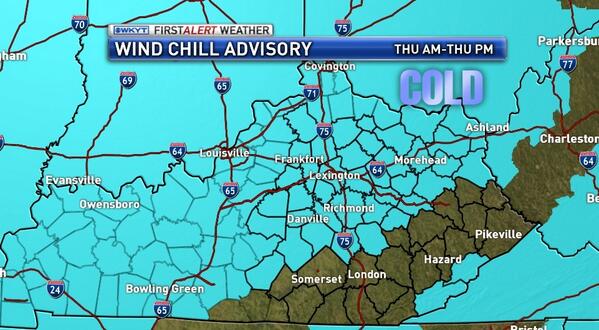
Don’t ask me why there is a sliver of counties not included in the advisory. The “cuteness” of these advisories is getting old.
Highs Thursday may not get out of the single digits for some areas. Lows by Friday morning head toward 0 or a bit below.
The next snow maker arrives late Friday night into Sunday…
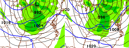 That will bring widespread accumulations to the region with 1″-4″ likely for many in central and eastern Kentucky. Gusty winds will blow that snow around and create terrible driving conditions.
The next system arrives late Sunday in the form of a monster arctic front. This should produce another round of light snow, but will deliver even colder air. Yes… even colder air!
It’s possible for much of the region to spend several days in a row without temps getting above 10 degrees. Below zero temps are VERY likely next week!
See you guys later tonight. Take care.

Thanks for the update Chris, Just a question here, a lot other weather outlets are calling for 40 degree if not warmer weather Sunday ahead of the next cold outbreak wondering what your thoughts are on this??
I wonder the same thing. The ever wrong Weather Channel has 46 !?!
wow!
thanks, Chris.
Thanks for the update, Chris. Hope the trip is going well.
I’m freezing. Not complaining, as we need cold for snow. I want more snow.
I have never stayed in Minneapolis/St Paul. But despite being somewhat of a nervous flyer, I have been traveling a bit more for business reasons in recent years and thus have connected through the MSP airport a couple of times. Besides the 1960s era main terminal making you want to peace-out 😉 , you also get an idea how much winter is a part of Minnesota. Many terminals across the nation have new cars on display by local dealers, but the Minneapolis/St Paul terminal can also have dealer displayed snowmobiles by the airline ticket counters!
While Minnesota does have brutal winters, their summers couldn’t be better. I went on a wilderness camping trip there many years ago during August. While Kentucky sweltered in the 90’s under the August sun, Minnesota was in the 70’s with much lower humidity. I would take their summers over ours any day. However, they can keep their winters.
One word about Minnesota summers. Mosquitoes.
Okay more than one word.
Mosquitoes The Size Of Your Head.
Have some very light snow falling in Nichvegas
What area of the state are you in Emerson?
Im mm in Nicholasville, just south of Lexington
Ok thanks was’nt sure
I’m sure we will be in school until June 25th at this rate. 😀
Relax…it’s all relative.
A couple decent snow bands showing up in Indiana, maybe a SURPRIZE inch tonight?
isn’t any inch a surprise ? lol
Alot of folks in seast KY would agree, not so much in northern KY!
lol You hit the nail on the head with that statement Todd! Actually, shocked would be a better word though.
That’s what she said!
Always is in Nelson Co/Bardstown…LOL! 🙂
I seriously LOL’d at that one.
Looks like I’m going to have to sell my motorcycle.
l don’t know but for some reason, I love seeing frozen, snow-covered ponds and lakes. To you all long-timers ky residents, do the lakes and ponds freeze often? Or is this usually something rare or uncommon? Last year, I only remember one time a section of a pond was snow covered, but now its all, and for a long time too.
Israel, I’m 32, and I can remember in the 80’s and 90’s, I could walk on the ponds and creeks here in the winter… It’s been several years since I’ve seen them freeze like that…
Not happened in a while
Ponds always freeze, smaller lakes almost always as well. Large lakes especially those with some sort of a current (dammed up river) are harder to freeze.
I live across from a 20 acre lake here in Northern KY and it takes it a lot longer to freeze than small farm ponds, but in the 12 years I have lived up here in Boone County it always freezes over eventually for some period… even in the winters of recent when it didn’t go below zero.
Temps holding in the low 20s since this afternoon here in knott co
Thanks Chris! Cold. Cold. Cold! Hope we get the snow to go with the cold! Stay warm tonight everybody!
Burrrrrrrrrrr!!!!!!!!!!!!!!!!!!!!
I surely am dreading to see my electric bill with all these cold arctic conditions…and things aren’t looking up too good for the next few days…er weeks maybe? Sorry folks, I just ain’t fond of snow, ice, frigid weather and all that comes with it… Wished I lived in the deep south at times…but was born and raised in Ky…We’ve had the worst winter that I can remember in a long time…It seems like SE KY gets in on the action about all or most of the times.
Wee another coating on the way
Played in the snow earlier with the kiddos! It was pretty rad!
Joe Bastardi is comparing the coming days (next week) to the Arctic outbreak that occurred inauguration day 1985. That’s some serious cold! I remember that time well. -24 degrees with a big snow on the ground in Morristown, TN. Here is a really cool, in depth explanation of his thinking from a video on his website http://www.weatherbell.com/saturday-summary-january-18-2014
Interesting stuff, has most of KY with a foot of snow on the ground by Super Bowl time!
1985 featured a very serious cold snap for most of the SE. Coldest temps since 1899 in many places. I think Lexington hit -18. Temps were lower in Middle and Eastern TN due to a snow Lexington didn’t receive. It dropped into the single digits as far south as North Florida.
That would take care of the python problem in Florida today!
As in wild pythons slithering around? I hadn’t heard of that! That could potentially be as bad as the gators!
Yeah, it was by far the coldest day in my memory. I would love to see the snow we had at that time but not the temps.
I was out of the country then so missed that. Not sure where CB got that Richmond was -15 this morning. Unless that was some spike in the early hours, it was -3 around 6AM.
The mesonet station in Madison County.
Band of snow developing just south of Indy, NWS is thinking about a special weather statement addressing a possible inch or so of snow in southern Indiana and northern KY!
Hopefully this fires up and gives Ky a nice little snow tonight?
Snowing in greenup!
Where’s mr blowtorch? Bwahahah
This is one time i wish Bryant was halfway right..Dreaded electric bill’s..Worrying about frozen pipes Etc,Etc..I just hope we get at least a foot or more of snow one time so winter can be over with..Time to start thinking about gardening..
Bryant is still around. He has conceded already that he was wrong. He a good feller though.
Looks like the 00z NAM is matching CB’s thoughts for the next 84 hours.
http://wxcaster.com/gis-snow-overlays.php3?STATIONID=JKL
Most, if not all of this is for Saturday too.
That convective squall of snow along the cold front seems to be enhancing a bit as it heads south. Won’t last for long, but Belski mentioned that it produced heavy snow and whiteout conditions further north in Indiana, and someone on Wave’s facebook said they received a quick inch. Could be a fairly intense half an hour or so if you’ve gotta be out late for anything tonight. Looks to move into Louisville in the next half an hour or so.
If we get an inch out of this it will double what i got yesterday
Looks like Louisville to Owensboro is the sweet spot for this squall line coming in, Frankfort area on the edge at best, some lucky folks will get a quick 1/2 inch or more in a short period in the sweet spots!
Really starting to come down in NE Louisville.
Heavy burst!
You are ground 0 for snow this year! Congrats!
Loving it!
Can barely see the house across the street in J’town (louisville). Stepped out for a minute to flurries and as winds gusted through started pouring extremely fine snow. Quick coating on the roads and pavement.
Looks the squall line has choked comin toward frankfort, oh well, hoping for more snow this weekend, but 40 s are showing up for Sunday more and more?