Good Wednesday to one and all. We have a brutal stretch of winter weather underway here in the bluegrass state and across much of the eastern half of the country. Wicked cold temps and more snow is on tap for the next week, at least.
Today starts out with many thermometers below zero across central and eastern Kentucky. Here’s a look at the numbers from the Kentucky mesonet sites…
Today’s lows

Current temperatures

Thermometers this afternoon will jump into the mid and upper teens for many. Winds will be very gusty ahead of another shot of arctic air blowing in tonight. This may produce a band of light snow as it sinks in…
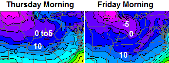
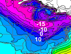
This keeps the bitterly cold air around. Check out the morning lows for the rest of the week…
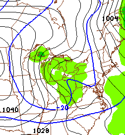
A potent system will swing in Friday night into Saturday and will likely bring widespread accumulating snows to the state. This could be another 1″-4″ system taking shape…
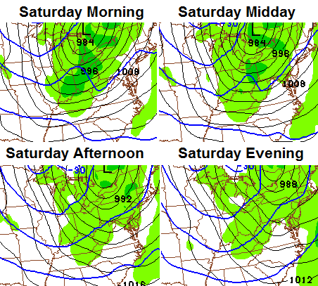
Travel on Saturday is likely to be ugly with the snow and gusty winds. Temps will drop back into the low and mid teens by the late afternoon.
Another system will swing in quickly by Sunday into Sunday night…
That one will try to develop into something bigger than the models currently show. Regardless… it will unleash another brutal blast of cold…
 This pattern isn’t going to be going away anytime soon. It is likely to carry us into early February, at least, and could feature bigger events as we move on.
I’m not sure when I can update today, but I will give it a try at some point. I will be able to fire up twitter through the day, so follow along.
Make it a great day and take care.

Epic early morning journey’eh!?!
Woooohooooo!!!!!!
So satisfied that I got the at least 2″ system I was looking for. Chris seems right, been hearing a lot of other mets say this pattern will carry into February. If we have all this cold, we’re BOUND to have a strong southern system somewhere in our area, but then again, weather is weird…..
Any one know where that blowtorch guy is?
Bryant has already “gracefully eaten his words”, but I for one wish he had been right about the warm temps, snow or no snow. I really hate this extreme cold.
Does anyone know why Chris is up north?
I don’t know……….But the transition when he returns will likely be a very easy one.
-6 in Lawrenceburg. Lexington has officially gone below zero for the third day this month. Most in any season/month since 3 in February of 1996. Record low is -5 for today.
Not much snowpack at my location, temperature is a balmy 2 degrees at 5:00am
I did not get to post my final snow total…a whopping 1.5″ in Valley Station in southwest Jefferson County about 10 miles southwest from Louisville Int’l as the crow flies.
My season total stands at 7.3″, while Louisville Int’l is over 11″ now.
That is wild Mike…you are at 7.3″ in SW Louisville.
SDF is at 12.4″ and Worthington Hills (NE Louisville) is at 16.5″.
What a range for the same city!
-2 this morning for the ride in to work. Totaled 5 inches of the white stuff.
-2 in west liberty it’s cold
-9 in Lawrenceburg; -5 in Lexington. Coldest morning in 10 years.
What’s up with the -13 on the mesonet for the Richmond area?
That’s probably the correct value. I have -9 in Lawrenceburg, it is -7 in Frankfort, Lexington just went to -6
I know it’s -6 at the airport in Lexington……But what’s crazy is that it’s only -1 at the mesonet. What is up with that? In addition to that, I find it odd that is colder in our area right now than in Minnesota…..I realize it’s because we have a snow pack, but so do they, I’m sure. Seems ODD.
That mesonet low for Fayette County is odd. Look at all the readings surrounding it.
The temp at my house in nw lex now shows 2 degrees lower than when the polar vortex rolled through.
Thank you Chris
Bring on rounds two, three etc
Maybe we’ll get a big snow for all the blog
folks!
Brrrr
So temps bust on the warm side Monday and the cold side this morning what a weird pattern.
2° as I get ready to leave Columbus.
Be safe. I’ve heard that much like doctors, EMTs make terrible patients 😉
LOL yes. I got back about an hour ago to Danville.
Some valley areas here in e. carter co, have hit -6 this morning. With about 3 to 31/2 inches of snow on the ground it sure is dangerous out there.
WKYT forecast low was 3. Home thermometer put the temp at -14. Only 17 to 18 degrees off! It’s interesting that we end up so colder than when the low temps were part of the urgency of the last time.
-15 means Madison takes the Mesonet crown last night. I swore I saw dire wolves and white walkers this morning at 6 AM.
Love the Game of Thrones reference!!!
Winter came!!!
Something is definitely wrong with the Richmond reading. lowest reading I had last night from downtown Richmond was 1.3. This is from a reputable, accurate weather station. Another station I can see broadcasting on underground in Richmond had a low of 3.6.
Thanks Chris. Love how you take the time to post, even when you are way up there in the northern frozen tundra. 😉 Sounds like fun and games for the next week at least. Long johns are going to get a real workout. Hope we can get some of that snow down in the southern part of the state before all is said and done.
Everyone stay warm and safe today! Bundle up if you have to be out.
(This morning, I personally feel like Ralphie from a Christmas Story…’can’t put my arms down.) 😉 Have a GREAT Wednesday everyone! Thanks again Chris for all you do.
A balmy 1 degree here in London, with 2-3 inches of snow on the ground. If you guys want more Winter, I’ll predict the Blowtorch for February as well. Apparently, I have the power to make the inverse happen. LOL
lol
it is still at minus 1 degs at 8:50am with abt 5 inches of snow on the ground!!
Beautiful and chilly morning here in Clay County. The snow just blankets the ground. It is -2 outside at my house and we have 5 inches of snow.
Make sure all your cases of pop don’t freeze.
Can you just imagine how cold it would have been during the polar vortex if we had a blanket of snow on the ground. Just like someone mentioned, why is it so much colder here with snow on the ground than it is to the north with snow on the ground also?
Folks, we’re in the middle of what COULD be a very memorable winter. Chris has been saying that for weeks and I just read another met I follow who says the jet should split in two soon with juicy southern storms back on the map! Of course, that always means the possibility of too much warmth for KY and a cold rain. I understand that BUT my fingers are crossed that with this irregular cold and winter that KY just might be in the sweet spot for some white gold from the southern jet. We can all HOPE!
Trend always wins. It still hasn’t been broken here
Trend doesn’t always win. Sometimes the trend is broken. And this winter, there seems a higher chance of a trend-buster than in the past.
Agreed.
Agreed…But…we are overdue for snow on snow on snow…..Just hasn’t happen here in the Lou area for at least 20 years…Looks like the talk of warm air brings it north. Rain for most of Ky Sun/Mon
-6 low in East Morehead.. Stayed there for about 2 hours… Brrrr.
Had 4 here in knott this morning temps seem to be warming pretty fast in the sun, I say mid. 20s is possible today
Headed to Red River Gorge this weekend….wondering what the snow pack is like in the Powell, Menifee, Wolfe county areas. Coming from central KY where there is only a dusting…..Thanks!
We got right at 6 inches on the Powell/Wolfe line.
My home thermometer got down to three degrees overnight. I have two inches of snow in my backyard. (I’m in Harlan County.)
So CB, who’s in a more frozen tundra now? Lol Reason why we’re colder currently than Minneapolis is because 1. Winds are lighter allowing more effective radiational cooling and 2. We’re closer to the core of the cold high pressure, its more south than west. Think about how warm Alaska is also!
Any correlation between CB leaving the state and we get hit with what I would consider an “old school” snow storm? Don’t know but I find it interesting. Ha Ha!
Hey thanks Chris for all you do. Out here in the country just south of Mt. Sterling my backyard weather station got down to -8.2 last night. Now that is cold, thank God we did not have the winds too, the wind chill only got down to -12. We ended up with about 4 – 4.5 inches here. It was just difficult to accurately measure. Everyone stay safe.
Bailey gets these long-term and longer-term patterns right about 80-90% of the time, and I will take those odds over almost anyone else out there.
NWS in Louisville not impressed with snow chances in the coming days, if anything they even have us warming up this weekend with a chance of rain Sunday??
Again, they are always late to the cold party, Chris always nails down the pattern before these folks ever do!
Todd I do agree with what you are saying, but I also remember the NWS saying 1/2 inch for Lou Sun into Mon changed there tune throughout the day on Monday to WWA even put Lou. into a Winter Storm Warning for a portion of Tues Morning.
That is my point, they kinda Nowcast each event as it developes, Chris is seeing a accumulating snow for Saturday with temps dropping into the teens,
NWS is saying mid 30s with no mention of snow?
NWS Jackson also not impressed. Via their discussion….Estimating just over 1″ north of I-64 and 0.5 inch, all points south. Just have to wait and see.
Officially this morning went down in the record books in Lexington. -6 was the low breaking the record of -5 from 1970. The Cold Max for today is 19 from 1926. I believe that will be broken as well. That is actually the warmest cold max of any day in January. Chris said in his winter forecast he thought Lexington would record its first record low of the winter season since 1996 this winter. Good call Chris!
All I want to say is this kind of cold is total insanity. I want absolutely no part of it, even if it does come with snow.
Hit -8 this morning at my house in Northern Jessamine Co. We are going through the propane fast as the furnace is running most of the time. Just hope we don’t run out before the next shipment arrives!
NWS has NKY getting around a half inch tonight. Flurries in the south.
Headed to Red River Gorge this weekend….wondering what the snow pack is like in the Powell, Menifee, Wolfe county areas. Coming from central KY where there is only a dusting…..Thanks!
I would say the valley’s are fairly heavy and cold… ridges light? From past experience for what it is worth… Remember that cold air is heavy and dense!
Brian Goode from Wave3 Louisville said at lunch time news this extreme pattern may go until atleast valentines day period, WOW, this might compare to the late 70s winters yet? BOTS 🙂
3 below zero temps in Lex the most since 1996. 1994 had 5. 1989 had 8. If we get beyond that then we are in late 70’s territory.
Updated snow totals/low temperatures from NWS Louisville (click here) and NWS Jackson KY (link here).
A stronger system is forecast for Sunday as of now, but the bad news is the models are trending it further north of KY!
We could warmup Sunday toward 40 degrees, then just flurries on the back side of that for Monday with the cold stuff returning, Hope this trends further south in later runs! We shall see??
Chris will have the last word on this! Bring on the snow!
I think that theres a good possibility that it will trend a little bit further south, because of the snow pack, but will it be enough to give us a skiff or a little bit more? I guess we’ll find out in time.
I predict we won’t be seeing 40 in Louisville for the next two weeks.
This will not be a rainmaker. But, if you like snow, it isn’t going anywhere anytime soon. Some people may get sick of the white stuff by the time this pattern is over with.
I’m not one of them 🙂
im gonna go out on a limb here .. tonight and this weekends snow im predicting a dusting to 6 inches area wide for each snow …that should cover everyone
Hey Chris
Noticed a big northern jump in most the afternoon runs of models for the weekend. Should we be worried or is this just a temporary glitch and will come back south.
Thx
Funny how TWC has frankfort reaching 26 today, NOT!
current temp 15!
starting to spit snow here in Louisville. can you say overachiever.lol
Whatever falls will at least stick! 🙂
Temp reached low 20s here today, sun worked over a great deal of the snow in spots sun hits
NWS in Louisville really buying into the warmup for Sunday as of now, their hinting at temps running toward 50??
WKYT has us in the upper 20s both Saturday and Sunday!
Let the games begin! 🙂
I read that in the forecast discussion. Remember how high temps busted the day the first arctic front came through? I think I fell from 58 on Sunday afternoon (the 5th) to -2 by the same time on Monday (the 6th) to -7 by Tuesday Morning (the 7th). I wouldn’t bet against the warm air.
Oh I think it’s very possible to get that warm in this area, but just fun to watch who caves first on the cold VS warm forecast 🙂
Planning on a Red River Gorge trip this weekend and wondering what the snow pack is like in the Menifee, Wolfe and Powell county areas. Coming from central KY where there is but a dusting. Any info appreciated. Thanks!
I just watched a video from Bernie Rayno from Accuweather and he’s thinking the possibility is there for the storm system on Sunday and Monday to dig further south than the models are currently showing. This would put most of Kentucky and possibly down to I-40 in Tennessee in snow. Granted he didn’t seem to have confidence at this time in this happening, but pretty much said he doesn’t buy into the models with the low tracking further north. What the more southern track has going for it is that the models didn’t see the track and intensity of yesterday’s system until around 36-48 hours before it happened. Even with the northern track it looks like areas just south of I-64 and further north could see some snow.
thanks so much to the amateur mets filling in with great info!
alos a shout out to the folks who tweet the great pics that Chris retweets. some beautiful work!
come on SNOW…we’ve really got the COLD
A few snow flakes falling in frankfort, so its reaching the ground here already!
Lexington set both a record low and record low max today (-6/15). It is rare to do both on the same date. The last time it happened was October 8, 2000.
I was going to ask that question but I found it already, but here’s another, last time it did that in the winter???
Based on the NWS discussion, I guess the message of the day is this. Just when it looked like an epic pattern (at least for this area) was about to set in, the GFS finds a way to warn things up to turn a snow storm into a rain storm with a few flurries on the backside.
The GFS stinks, but that has been the pattern all winter. Every big cold shot has been preceded by a storm that tracks to our north, floods the zone with mild air, and gives us the old rain to flurries forecast. Yeah (not really).
Don’t put too much in the GFS yet. Give it another day or two.
The other models have moved in the same general direction, so booo.
A sugar coating of snow has fallen in Frankfort, tiny flakes still coming down at this moment!
Its Official. Propaganda of Global Warming = Dead
Except for the fact that global warming can inadvertently be causing the very weather we are experiencing across the “world” (not just here at home) today. Not saying that I buy into global warming/climate changes, but it can’t be discounted just because we are getting some cold temperatures.
I discount it because of the very fact that the “science” has been debunked and its very financially motivated data has been exposed. Climate has always cycled and changes come with each cycle, been that way since…Forever
Very much agreed about natural cycles, but I do believe that carbon emissions have to play a part in those cycles today (speeding up the process, be it warming or cooling?). Whether the part they play is bad or not, and to what extent is what I question.
Question should be Do they actually play a part? Our atmosphere has amazing capabilities which filter out these emissions. Its our increasing Technologies that allow us to see more of the weather phenomena and environmentalists have used that to create fear and unnecessary panic about our “Carbon Footprint”