Good Saturday evening gang. Today was about as wicked of a winter weather day as you can possibly get around here. You don’t need me to recap it all since you are living it. Where do we go from here? I thought I would drop by for a bit to touch on that.
Temps tonight will bottom out around zero or a touch below in the colder spots. Wind chill readings will be well below zero.
Sunday is a very windy day as another arctic front approaches from the northwest. This won’t get in here until late Sunday night into Monday. That will allow for temps to shoot well into the 30s ahead of it. This front is likely to bring a pretty good burst of snow behind it Monday morning…
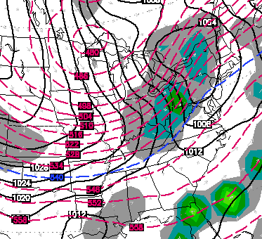
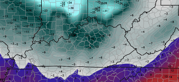
Light accumulations with that can cause additional travel troubles. Winds will gust to 30mph at times as thermometers fall all day long. We will be in the teens by the afternoon and in the single digits by early evening. This leads us to what I think is the coldest night of the entire winter. Readings by Tuesday morning can approach -10 in much of the state.
The Canadian Model is going nuts with the lows…
The sad part is… something that extreme can’t be ruled out!
I’m looking more and more at February turning into a WILD month. The pattern I see taking shape can bring major storm systems our way with a few arctic blast still to go. I do NOT think we have seen the biggest snow of the winter.
See you guys later tonight. Take care.

Dodger says HURRAY for lots more snow! Great job, Mr Bailey! Dodger!
Chris man I hate snow and cold.I’ve had enough of this.I can’t handle this weather anymore man.please forecast some warmer weather man.
Well, the KY folks who have bene hollerin’ for snow should be pleased with this one 🙂 If not then y’all need to move to the Lakes and Mountains of West Virginia where we’ve got 14″ on the ground and a lot more on the way by way of Lake Effect!
I agree,I’m from eastern Ky.but living in Lesage,Wv.for now.We had 14 inches before a blizzard with thunder and lightning came through.I can’t wait to remeasure in the morning!
Anyone wasn’t t guess how much snow cover will we loose tomorrow in CKY?
Okay… Let me try that again… “Anyone want to guess how much snow cover we will lose tomorrow in CKY?”
Out of the near 4″ of snow we got today. more than half melted this afternoon. I would imagine there won’t be a trace left by tomorrow afternoon. Was beautiful while it lasted though.
a very nice squall line moving out of nky into wv with thunder and lightening being reported …nice
I thought today was pretty nice in Lexington. The mid 30s and warm sun was very welcome.
This evening, however, sucks 🙂
Snowing again in Pikeville ,I guess it won’t last much longer.Thanks Chris for all you do please get you some rest.
Interesting to have these temperature swings when we finally get a great snow. At any rate, I enjoy the contrasts. Looks like we’ll be out of school at least Tues-Wed for extreme cold. Wondering if we’ll be out Monday, since we’ll likely have a lot of melting tomorrow.
cold front with some snow is suppose to sweep through early morning with temps crashing all day, so probably.
I like to see the snow come but I am not one for liking it to hang around to long.My driveway is shaded and steep so it takes forever to clear with just a small amount of snow or ice.The sun today was welcome.Probably got rid of about half of what was on the driveway.Hoping tomorrow will get rid of the rest of it before the next round comes.
I am getting tired of the really cold temps too.Costs so much to heat.
We’ve been keeping the thermostat at 65 for most the winter. Still expensive :/
Dodger says listen to those complain about lack of winter. Get winter and now complain about heating bills. You might consider moving. Dodger!
Not complaining.I like all seasons but sometimes I get to the point I am ready for it to change.Feel the same when we have 90 to 100 temps in the summer.Even the cold is nice but we have had days and days of it so yes temps in the 20s would be better than zero or minus for me..as for snow a little dab will do me.Won’t see me on here wanting lots of snow.
I have a lot of concern for the elderly especially that have limited income to pay for heat.They try to cut back to save money and that isn’t not a good thing for elderly people to do.Most have circulatory issues.
Even if we warm up tomorrow. ..The ground temperature is still very cold…idk if the snow will completely melt.
Those teachers and kids our going to start rooting against you if you don’t start forecasting spring!
Not at all disappointed in the snow we received here in Louisville today. Did not like the 40 degree temps that melted all the snow.
Heck I have less snow now than I did this morning before it started snowing.
Hope CB is right on his thoughts of more snow and a big one. The bubba buster is a coming.
I shall remember my fateful New Year’s Eve at Target when I stared straight at a new metal snow shovel and decided it was doubtful I would need it. My sons and I used two regular dirt shovels and one plastic snow shovel. It took longer and was less successful with those.
Why is the temp going to drop to zero and then back up to 40 again? Seems it would not get that cold tonight.
Or may not get that warm tomorrow it works both ways
True, but going by CBs post.
The last time our driveway had that much drifted snow was 1998, but that was two to three feet of snow over the whole thing. This was 8″ to 18″ deep.
I remember back when you could go to target or walmart or any hardware store and get any kind of sled or plastic snow disk you wanted along with snow shovels and salt. I haven’t seen any sleds in stores the last few years.I had to clean a lot of dust off some snow toys today. I’m glad we saved them hoping one day we might get to use them again.
No demand, no stock. That says it all about the lack of snow to actually have fun in, through the years in many areas.
thanks chris, still read your blog,old wsaz fan of yours!
I’m a happy camper! Really interested in hearing more about the weather for February!!
We still had 3 or 4 inches left from last weeks snow, and got abt 4 – 4 1/2 inches earlier today then we had THUNDERSNOW this eve and got abt 2 inches in abt an hr, So abt 6 to 7 inches fell today and we had 5 inches a few days ago, Awesome winter here so far!!!!!
It seems like we got the best of it sue! I measured 10 inches on our ridge a few minutes ago..it only got up to 32 today
that Thunder snow was crazy! But beautiful!! We may have more then 7 inches it was so hard to measure with the way it was drifting, I had abt 10 – 12 inches on the rail on my deck! My kids got to eat snow cream for the first time today! they loved it!!!!
Chris re tweeted my pic of the snow on the my deck
I hope we haven’t seen the biggest snow as 2 inches is nearly insignificant but hey at least it was enough to measure this time.
And the folks in North Dakota said they were expecting to worse winter they’ve had in years. With temps at 45° in Williston yesterday I’m ready to go back and warm up. Lol
-16 on Tuesday morning? Someone call Wisconsin and tell them they can have their weather back!
Noticing large coverage of blizzard warnings/winter storm warnings stretching southeast, now into Illinois. Is that a sign of things to come for tomorrow night?
fingers crossed!
From what I can tell on the model runs the heaviest snow will stay north of Kentucky in Indiana, Ohio, Michigan and states eastward from there. Parts of central and most of eastern Kentucky will see snow showers pop up along the cold front as it moves through. Not a lot of accumulation with this one.
18z GFS
http://wxcaster4.com/gis-gfs-snow-overlays3.php3?BASEHR=18Z&STATIONID=JKL
18Z NAM
http://grib2.com/gis-snow-overlays3.php3?BASEHR=18Z&STATIONID=JKL
wow! thanks! as for school on monday, looks like black ice would be the only reason for being out. according to those maps, snow may not be an issue, especially after probable melting tomorrow.
Read someplace that 1/2 inch or less as the system comes across.So hopefully not to much.
Pretty much what Jim Caldwell said on the news this evening. Still looks impressive on the radar.
Two comments: First, the snow squall accompanying the front dumped three inches of snow in fifty minutes at our house five miles north of 1-64 in Ashland Ky this evening. Second, if Chris’ comment about February materializes, it suggests to me it could also be a wild tornado month too.
Thunder Snow! St. Albans, WV 6:30p.m. Active snow storm and windy conditions. Additional snow accumulation 3″. We have a total of 7″ on the ground.
Was nothing more than a morning nuisance in knott co, roads where in good shape by early afternoon
We got nearly 4 inches if snow here in my part of Pulaski County. It was snowing so hard when it started that within 45 minutes, when I went to work, we had over an inch. So beautiful seeing it snow like that! Would love to see a great big one still, but at least we have had some this winter. Chris, once again, you proved why you are the BEST weather dude around! A big thank you to you and the whole KYT weather team! Kudos! Stay warm everyone.
Coffee I am so happy you got snow.
I am for a big one if I do not have to dig out to get cars out. Ain’t it funny how you tend to latch on to the good things? Digging out today from “Drift Central” reminded me of the negative side of lots of snow. A malcontent I be.
I am moving back to Alaska where it’s warmer. 😉
My area of Louisville received about three inches of snow, but the temperatures spiked quite a bit this afternoon. Since I don’t live at the airport, I don’t care what their reading was. Having said that, we reached at least 38. Probably an inch or so of the new snow melted and the strong wind got rid of some of the snow as well.
It seems Louisville was about the furthest east the warm air penetrated so those in LEX and FFT lucked out. If the temperature does spike towards 40 tomorrow, I suspect much of the snow in the Louisville area will be gone before the super cold air arrives. The NWS is calling for 43 for a high.
East and central KY gonna get a cold RAIN next weekend. Dodger says get a good look at that snow ya got now. It won’t last past Wed. Dodger!
Bubba says talking in third person has a very Silence of the Lambs- Buffalo Bill vibe. Ruh roh, Bubba just did it too! Doh, did it again!
Agree strange, Mr third person??
Yep some sites have temps in the 50s and rain to start February off.Actually the whole month seems to be forecast to be in the 40s and 50s.But a lot can change for sure.
This pattern reminds me of February-March of 1996. 80 degrees one day heavy snow the next. Hopefully UK will play like it is 1996 🙂
When we get to mid-February average highs start hitting the 50s. Starts taking the perfect scenario for temps, moisture, time of day, etc…. to all come together. I would rather get our dome buster in the next couple of weeks and move on. Once March gets here (especially after this kind of January) I will be ready for the warm days to outnumber the cold. Don’t want a repeat of last year where it was mid-May before we started warming up.
Your weather forecast is the most accurate one out thier right. I am a UPS driver in eastern ky and weather has a big impact on my job.i check your forecast at least 3 times a day. Keep up the good work.
Crazy thunder and lightning snow came through cross lanes wv around 6:30. Dropped about 3 inches in 35-40 minutes. Hardest I’ve seen it snow in a long time. Have about 7 inches on the ground. Roads are rough going in many spots.
If that map is representative of morning low temps; that is stupid, stupid cold. I don’t think my car will start in that. Car blanket anyone?
WHAS and WLKY both suggesting very warm afternoon weather for Louisville. Both have highs at 46 degrees.
Sounds about right. Snow, we hardly knew yah!
If the sun comes out, it will get slush funky tomorrow. Hope we get a lot of wind to help dry things out before the cold air sets in. Safer roads and kids back to school on Monday! 🙂 Had we not had these warm spats, the kids would be out another week. Kids and teachers need to be collaborating in school. This is true.
Heat MISERS!
test