Good Sunday, weather weenies. We have a relative heat wave moving into the state today as temps surge into the 30s. That’s right… the 30s constitute a heat wave nowadays. Make sure to run out and soak it in because the coldest air of the winter is on the way.
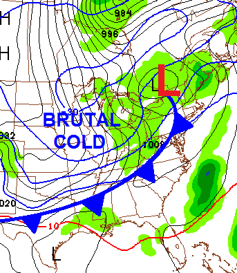
Calling this air mass the coldest of the winter is saying something considering the amount of brutally cold temps we’ve had. But, that is indeed the case and that’s a scary thought. The arctic front responsible for the latest round of brutality arrives on the scene late tonight and early Monday.
It is likely to have a band of light snow and very gusty winds behind it…
That can put down some very light accumulations for some and it could be enough to cause a few more slick spots on roads. The GFS is a bit more robust with the Monday Morning snows…
The cold air is center stage as temps crash through the teens into the single digits in the late afternoon and evening.
Tuesday morning is when the absolute bottom may fall out of your back porch thermometer. Below 0 temps are very likely and we could see some areas hitting -10 or lower. Highs Tuesday will stay in the single digits and we could see another round of 0 or below by Wednesday morning.
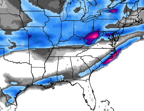
I’m watching for a light snow maker for the end of the week and then something else is going to try to form for the weekend. The setup over the next 10 days will feature systems rolling just to our south and east. These can put down snow around here. Check out the Canadian Model 10 day snow map…
Looking farther down the road… I mentioned earlier how I thought February was looking to be a wild weather month. I believe this to be the case because the arctic air across the country isn’t going anywhere. I do believe it will be oriented a little differently than what we’ve seen lately, though. Throw in the increasing chances for SOME milder air to show up across the southeastern states, and you have the recipe for wild. The latest 45 day temperature anomaly map (in Celsius) from the CFS shows what I’m talking about…
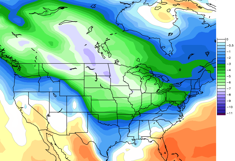
That is a pattern that will likely crank out some BIG storm systems rolling from southwest to northeast in the eastern part of the country. As stated… I don’t believe we’ve had the biggest snowfall of the winter, yet.
I will update things later today. Have a good one and take care.

Temps surged into 30s near 40 yesterday , temp is holding around 16 here in knott co I figure mid 40s for highs today
Milder air is also a recipe for Freezing rain..Just look what the Canadian is spitting out..I know it’s long range but it’s a good example what can happen when you start to flirt with the freezing line..
http://meteocentre.com/models/gemglb_amer_00/PT_PN_204_0000.gif
Looks like the the weekend system CB mentioned above in his post. We don’t want that!!!
So instead of negatively tilted systems, bringing dry cold from the “eh” of Canada, (sorry to my Canadian friends); we’ll have positively tilted ones coming up from the “oh” of Texas and the Gulf?
Considering the south winds already cranking per the Mesonet sites, I believe most areas south of I-64, or any areas without snowpack, will easily climb into the 40’s today. Better enjoy it!
Andy Rose you will hit 40 today.
I dont see a 40 degree rise on temps i say mid 30s
Knox Co Mesonet already shows 28F! Better break out the shorts!
Biggest snows in this part of the state have always been in Feb. Just sayin’.
We are now above are normal average for snowfall her in the Lou. area. Hopefully we go way way above normal before end of March. Like someone said above, we have seen some of are bigger storms in Feb and March. The set up in the bottom chart is pefect for an Apps runner….Heck hopefully all the system that roll through over the next month become Apps runners. Ice will also be in the mix as you know we can’t get away from icing in some parts of KY.
Stay warm after today and THINK RAIN!!!!
I really have a hard time believing the temps rising 40 degrees as the NWS is suggesting
It’s in the low 20’s now……..if the temp gets to 40 today, that’s not a 40 degree temp rise.
Sorry but the low was 7 if it gets to 47 as predicted thats 40 degrees
Already 39 here in Knox Andy. Looks like it may make a run at mid-40s. Lexington was 12 degrees warmer overnight than the lows wkyt had predicted.
I went to town and it was quite a bit warmer there than at the house. I hope the kids go to school this week Bob but unless they get the roads cleared today I don’t think there will be unless they get creative.
Wow…Knox Co. Mesonet up to 52F now. Even I didn’t think it would get that warm. South winds doin’ their magic.
48 here in Grayson, in NE KY. I would never have believed it. Snow is melting quickly but some side roads that had the snow packed into ice are still covered.
Thanks Chris. Gonna get out for a bit today and do a couple of things. I do not look forward to the brutal temps and I have to be out in them off and on so I am thinking the long johns will be mighty handy. Everybody have a great Sunday. Thanks again Chris for all you do.
I thought it was going o be like 5 this AM?
If I read correctly, we were supposed to be around zero last night, but we were in the upper teens. Given this big difference, would that not also extend into the flow of today? Seems 40’s are an easy target for a lot of us. What am I missing here? Just asking.
We also got a lot warmer during the day yesterday.
The Mesonet low temps beg to differ. My own should 3 degrees last night. How was it only in the teens in Richmond last night?
However, yes the temp high forecast was noticeably off yesterday and the forecast for today is only 28 and we’re already at 35. There never seems to be an explanation for when this happens. And, yes, I realize it’s heresy to even point it out in the first place. 😉
The Mesonet appears to be under the influence in Richmond.
We were at 7
NWS forecast for Somerset for today and tonight:
Today Mostly sunny, with a high near 46. Breezy, with a southwest wind 9 to 18 mph, with gusts as high as 29 mph.
Tonight A chance of rain before 2am, then a chance of rain and snow. Increasing clouds, with a low around 26. Southwest wind 6 to 11 mph, with gusts as high as 18 mph. Chance of precipitation is 40%.
We actually hit 39-40 yesterday Chris after the snow.
Seems there is a temperature disconnect as far as this weekend. Even when considering the average.
Expect to lose a large chunk of that snow pack in Lex today.
Yep. Perhaps some mid to upper 40s to melt the snow and wind to dry it from the roads before the cold air arrives. Catch is I have noticed there is a LOT of salt in places. I get why you would want it on hills stops and turns, but saturated everywhere? Worse I recall seeing and easy to mistake for snow or ice in the distance.
Not talking salt coverage, but OVER saturation of the stuff.
They do that here with every event so much so you cant see the paint on the roads
Where I travel in the Cincinnati area, there was so much salt on the roads before yesterday’s event that you couldn’t see the lines marking the lanes.
That warm front today means business. It’s already in the low 40’s in western KY. I think locations in south central KY will hit 50 today.
Only in Kentucky, specifically Louisville, can we have a four inch snow, a three inch snow five days later, spend just five hours above freezing, and yet lose almost all of the snow by the end of the sixth day. Crazy.
As for the upcoming period, fingers crossed. Hopefully we’ll end up with a good storm, but I was hoping for one of those record breaking periods of snow on the ground. That’s not going to happen. It might get close to 50 in Louisville today. Unbelievable.
I think ice is a bigger possibility than big snow, based on how the warm air has factored in and how these systems have played out in the past years.
It’s a balmy 37 degrees in Greensburg, Ky. Thanks Chris for keeping us “weather weenies” informed.
Knocking on 40 with sunshine in knott co well before noon, upper 40s seems very possible
It’s gone up 7 degrees in one hour in Lincoln. With clear skies approaching, mid 50s look possible to me. That’s a pretty big miss on the temperatures if it happens. It’s already 38 here at 11:30!
Looks like temps are going to hit on the high side today. So long snow. The Canadian snowfall map kind of sums up the season. Southern Kentucky is showing to be in the low to no area again. Wonder if the temps are going to bottom out as predicted this week? The weekend came in much higher than predicted.
Still confused why CB is not picking up on the temps for yesterday and last night were a lot warmer than forecast and today is going to likely go into the 40s for much of the state. Either that or my reading comprehension skills have gotten worse.
I’m already at 48 so low to mid 50’s seem possible. I only dropped to 24 degrees last night, a huge miss on forecasted lows. I had about 7 inches of snow on the ground yesterday morning and am now down to less than 2 inches. Warm southerly breeze plus bright sunshine equals a snow eater kind of day.
Hopefully he hits on this in the evening post. I would also like to know if the lower portion of the viewing area is going to be in on the “historic” cold. Some other sites are showing the Lexington area to be cold, but my area is only showing mid-single digits for lows and mid teens for highs. Still cold, but not near as cold as we had a few weeks ago. My preparation for the upcoming cold will be a little different if lows are -5 instead of 5 above.
We are probably going to hit the 50s today in Knox Co.
Major BUST in high temps today, KY hates a good snow cover, get ready for a dry cold week, doubtful this next batch is record cold without the snow cover! Might layout in the sun today!
CB has significantly missed the temperatures now for yesterday and today for high and lows. Glad he did, since this will melt and dry out a lot of the snow on roads and especially my driveway. Already has helped big time 🙂
When you think of it as a positive instead of the others who use it as an excuse to be jerks, then that is all good.
The warmth and wind today is an ally to the snow moving weary, but perhaps an enemy for some expecting to be off school tomorrow. That is unless we get a little snow before.
The counties with all the hollers probably will miss school until March. Hoping it is a joke.
My road was completely snow covered and is now a quarter way melted. If all the snow melts on roads, seems like school would be in session tomorrow BUT what could stop it is the light snow forecasted tonight-tomorrow morning. If its an overachiever, or hits hard during morning rush hour, schools will likely close again.
I love this “heat wave”! Really does feel nice outside for a change. Sorry, Chris, but I really do hope your forecast for extreme cold this week is dead wrong.
46.8 here and the roads are still covered, but I do live in a hollow where it will not until next weekend at the earliest.
Rain tonight will take care of it!
All 20% chance of it
Knott county by the way
60s today in West ky?
Anyone else notice the snow along the gulf coast stretching from Brownsvile TX to Florida.
37 here in greenup..it’s cloudy tho so snow melt is very slow
I think us here in northeastern ky got the brunt of the snowfall
This warm weather today proves a good snow cover means nothing if it wants to warm up! 60s in west KY, WOW, 70 degree temp swings in this state in just a couple days??
Looks like a nasty wet pattern next weekend into next week.. I wonder if it will be raining/snowing on the Superbowl?
Yep, already seeing the rain word with mid 40s next weekend showing up, Might be a nice change, these small snows with extreme cold is getting old!
Best snow of the year fell in Frankfort yesterday 3 or 4 inches, now to see it melt today really sucks! Reminds me of March!
If this takes care of the roads today then I am all for it. CB is awesome even if things happen that we don’t always expect with weather. I can only imagine the complainers if he was around during the ’98 “dusting” and blogged about it.
He called the snow with the most accuracy, so got that.
The models must be horrible with temperatures. It’s 40 in Harrison County. I don’t see temps getting as cold this week as originally thought and that’s not complaining because below 0 is tough on water mains and water pipes.
With the mid 40s and sun I bet the car washes ar raking it in today.
I never understood why people wash their cars when there is still salt on the road.
Not a weather person just your average person with a question. How much snow would this be for everyone, especially Eastern Kentucky?
http://mag.ncep.noaa.gov/NCOMAGWEB/appcontroller/Image.php?image=data%2Fgfs%2F12%2Fgfs_namer_240_850_temp_mslp_precip.gif&model=gfs&area=namer&storm=&cycle=12¶m=850_temp_mslp_precip&fhr=240&group=Model+Guidance&imageSize=M&scrollx=0&scrolly=0
http://mag.ncep.noaa.gov/NCOMAGWEB/appcontroller/Image.php?image=data%2Fgfs%2F12%2Fgfs_namer_252_850_temp_mslp_precip.gif&model=gfs&area=namer&storm=&cycle=12¶m=850_temp_mslp_precip&fhr=252&group=Model+Guidance&imageSize=M&scrollx=0&scrolly=0
http://mag.ncep.noaa.gov/NCOMAGWEB/appcontroller/Image.php?image=data%2Fgfs%2F12%2Fgfs_namer_264_850_temp_mslp_precip.gif&model=gfs&area=namer&storm=&cycle=12¶m=850_temp_mslp_precip&fhr=264&group=Model+Guidance&imageSize=M&scrollx=0&scrolly=0
Sitting at 51 right now in Knox Co. First snow of the year over 1 inch and it’s 50 the next day. Hard to believe as cold as January has been that it hits 50 degrees the day after a snow. Only in Kentucky.
I was looking at the NWS and they are issuing a hazardous outlook for central Kentucky and south central Indiana for bitterly cold temperatures Monday into Wednesday. So I guess that we will still have the cold temperatures after this front comes through…thoughts??
Everyone south of a Louisville to London line already in the 50’s today. Even some 60’s showing up. South winds and warm air advection blowin’ away the cold, at least for one day.
If where already getting such temperature swings this early one can only wonder how severe thunderstorms will be in the spring, the battle lines will set up somewhere and it could be ugly??
Not sure where WeatherUnderground gets there extended forecast but here is what they show….Starting NEXT Saturday Night….Very Interesting to say the least…..
Sat Night -Showers in the evening with rain becoming steady and changing to freezing rain overnight. Low 28F. Winds NW at 5 to 10 mph. Chance of precip 60%.
Sunday-Snow during the morning will give way to a mixture of rain and snow during the afternoon. High 36F. Winds SE at 10 to 15 mph. Chance of precip 70%. Snow accumulating 1 to 3 inches.
Sunday Night – Expect periods of freezing rain. Low 27F Chance of precip 80%.
Monday – Freezing rain in the morning will transition to showers of rain and wet snow in the afternoon. High 37F Chance of precip 60%.
Monday Night – Light snow during the morning, tapering to a few snow showers during the afternoon. High 29F. Chance of snow 50%. Snowfall around one inch.
Tuesday – snow. Low near 15F. Chance snow 80%. Snow accumulating 3 to 5 inches.
Tuesday Night – Snow during the morning will taper off to light snow . High 23F Chance of snow 70%. 1 to 3 inches of snow expected.
Wednesday – Cloudy with some light snow. Low 12F. Chance of snow 60%. Snow accumulating 1 to 3 inches.
Wednesday Night – Light snow during the morning to a mostly cloudy sky during the afternoon. High 26. Chance of snow 40%.
Thursday – Partly cloudy in the evening followed by periods of snow Chance of snow 40%. Snow accumulations less than one inch.
Thursday Night – Snow showers early. Peeks of sunshine later. Chance of snow 40%.
Friday – Cloudy with some light snow. Low around 15F. Chance of snow 40%. Snowfall around one inch.
Friday Night – Light snow during the morning will give way to mostly cloudy conditions during the afternoon. High 26F. Chance of snow 40%.
Saturday – Mostly cloudy with a chance of scattered snow flurries. Low 13F.
Saturday Night – On and off snow showers will become widely scattered flurries by late in the day. High near 30F. Chance of snow 30%.
Sunday – Scattered flurries and snow showers. Low 14F. Chance of snow 30%. Snow less than one inch
That would be over a foot of snow, something tells me that won’t happen 😉
We can dream can’t we…..Baily said shots of snow will be more often over the next couple of weeks…..After the cold moves out.
This is for the Lou area…
if anyone is expecting any met. to come out and say how wrong they were on the temp/snow or anything ,dont hold ur breath…now if they hit it on the head , you ll hear about that in a hurry
Well, I personally would like to see that on this blog, if it really is an educational tool. I don’t have an issue with a met being wrong, but educationally speaking I would like to know why. 30s were predicted. We’re pushing 50. How come?
How come? WAA…warm air advection underestimated.
I would like to see all the people on here who foolishly criticize Chris Bailey use their real names instead of calling themselves “Realist” or “Big Poppa Snow”.
Ya know, unless you are posting your own forecast, you really shouldn’t be criticizing anyone’s. There is a lot of unwarranted and unnecessary bashing on here.
You’re right, MJ. I already know that I have the meteorology acumen of an aardvark, so instead of kvetching about a “bust” or Chris being wrong on occasion, I just roll with whatever happens.
with ya, Jeff!
I don’t get all the negativity and nit picking. I’m pretty happy with the snow and cold we’ve had so far. Chris has done very well with his forecasting.
-bonus points for using kvetching!
Do you get part of CB’s payroll check or something? Give it a rest, it’s the Internet, where everybody has a say.
How about you give it a rest?
54 in Pikeville
47 in my part of knott county but I’m in a place where the sun will not shine again til march!
Mid 50s here snow cover has took a beating here in knott co. Major temp bust
50 in Lincoln County & it was supposed to be in the 30s. Wish I had a job where I could be that wrong & still be employed!
OK, despite the major temp bust…that’s uncalled for. So, you are saying you are PERFECT in your job? You’ve NEVER made a mistake? Give me a break.
Some people just have to be ignorant douchebags. They have nothing better to do with their lives than hate on others.
Like you’re doing here? It was meant as a joke, buddy, relax a little.
I’m not hating on anyone, so your comment is invalid.
Well somebody else must have posted this from your comment above: “Some people just have to be ignorant douchebags.”
Whatever, the forecast is still a MAJOR BUST.
I think it is obvious to most the temps were a big bust, but the concern is the way your joke came across. Sometimes words alone do not convey intent or true meaning. That is my deep thought for the day. I feel sick now.
I’m pretty sure Chris sail a mild surge would push temps well into the 30’s. I realize that is not 50 but he did see the mild surge coming.
Hey watch the language please! There are kids in school that read this blog along with there school teachers.
What kind of job would you posses that you wouldn’t have a job if you were wrong? I hear that all the time. I have doctors, teachers, work foreman’s, and so on who are wrong on a regular basis, yet they still have a job.
You are officially under my watch!
60F in Bowling Green @ 3 p.m.
wow- only in KY!
ready for another round of winter!
Wow hard to believe all of the haters. CB has been way ahead of all the Mets this year on the cold and snow. His forecast is more point on than my local Mets here in Charleston which is why I continue to follow him. If not for him many times people would be caught off guard during bad weather relying on the national weather service.keep up the awesome job CB.
Could’nt have said it any better myself!
What haters? People asked legit questions since yesterday if the forecast for temps made sense, so expression towards this is understandable…… Well, depends on how conveyed, so your point is noted.
In some haters defense, if it were area that got diddly and ditto so far, venting is natural…….. Then, again CB said no venting on the blog, so again your point is noted.
Self centered me is just a happy camper it did warm up and lots of wind to dry things before the mega freeze kicks in 🙂 Removing snow when single digits or below can be futile. Less ice to deal with too.
How about a run at 50 with snow on the ground? 48 in Lawrenceburg. Everyone busted on this forecast today. Never underestimate the power of warm air!
50 in Frankfort, even the heat miser forecast I laughed at from Louisville the other day said 46 today, turns out he was much closer to being correct, Chris has a tough job forecasting our flip flopping weather in KY!
On a positive note, I will still have a snow drift or 2 and some driveway piles of snow left for the next cold spell 😉
sounds like a quote from MJs tweet
Yep. It just took the two combined snows to give us the biggest drifts in many years to make me appreciate it’s powah’!
If we do get a big snow chance, all I ask is no big wind to cause big drifts. No big ice either, but that is another one of warm air’s powers. Boo!
WOW…55* here in McCreary Co…..I think I like it!!!
Crazy weather we are having indeed. nearly 4″ of snow yesterday…..55 degrees and all that snow melted today except for a few extremely shaded spots. the warmth has given me Spring fever even though we have a couple of months left of winter and some cold shots.
52 degrees in London. Is it bad that I don’t want the snow to disappear so quickly? Just wish this week’s cold had a little bit of snow to go with it.
Have you seen this from GFS for next week?
http://mag.ncep.noaa.gov/NCOMAGWEB/appcontroller/Imageanis.php
While little chance, a big storm will hit again, even though some will deny. When will it? Of course that’s the big question, who knows. But I would say I have to agree with Chris’ comments that its more likely with this relaxing of the pattern and the setup forthcoming.
if its a week away it means nothing unless its ice as BubbaG says
Some heavy bands of snow breaking out in Iowa ahead of our next arctic blast, all is not lost, east KY could get a 1-2 inch snow when this front gets here!
The weather turns warm and blog turns ugly, can’t blame some folks, they final get a decent snow and Blow Tirch shows up and takes it!
Keep the faith, Chris says the best is yet to come snowfall wise!
Seriously…instead of being negative on the blog, GO OUTSIDE! Maybe some fresh air will help. 🙂 I was thinking that this warm air may help set up a nice squall line, or some good instability for snow. We just need another nice coating for this cold spell coming. Hate to just have cold and nothing to show for it.
So CB nails the snow forecast and the Negative Nancy’s and Debbie Downer’s can’t stand that so they have to trash him for not getting the temperatures exactly right today? I mean I can maybe understand your anger somewhat if he said it was going to be 70 today and it turned out to be 30. It was WARMER today than he thought! How is that bad for anyone??? Calm down, enjoy the sunshine and quit bashing the man!
Give it a rest it’s just the internet! Everyone has a say! 😉 🙂 😀
This is not a bash to any specific met but if we knew the wind speeds today and knew winds were from a certain direction, how were temps missed 8 hrs in advance by 20 degrees? You would think if you busted on the morning lows all the mets would at least correct the daytime temps???? I don’t get that at all.
This will make some of the snowless KY areas jealous, Winter Storm watches up in southern Alabama, Central Georgia, and most of South Carolina for snow and Ice??
Those who criticize Chris Bailey are just mad because they didn’t get “enough” snow….
Those who criticize NWS are mad because they don’t “forecast” enough snow…
These are just my personal opinions, but the two meteorologist I respect/trust the most are CB & MJ. They may differ on small details, but they both now their profession very well
Go Steelers…!
Did anyone notice there was no wind advisory issued fri night or Saturday? Winds gusted to 55mph!!!! Looks like LMK missed that one
Looking ahead and wondering what’s on the way can be fun, especially if your kind of weather is forecast. Today is a good day to get out and get some sun on your face and take a little walk around….I did and I feel much better. Whatever is on its way, I’m sure we’ll deal with it, and our weather guy will let us know as best as he can.
i don’t think its as much bashing or anything like that as it is why did this happen ,or what was missed ….bc missing temps by 15-20-25 degrees is not normal ….and secondly I think others would like to hear once in a while “hey I was off” or “I missed that by a mile” if that happens to be the case…im more of a fan of the stand up person that admits a mistake or wrong , than standing up and telling ya they were right
Bryant told us all it was going to 50 in January, he just thought for the whole month.
OMG people, whether it be bashing or not, let it go already! So Chris missed the forecast on the temps today…it happens. He’s still by far the most accurate met in this area. No one, nor no computer model in the past or going forward will EVER be accurate 100% of the time at forecasting the weather. It’s a mathematical impossibility…..mother nature will always have a curve ball to throw from time to time.