Good Sunday evening. Our extreme weather pattern is on full display again today as thermometers soared above and beyond my thoughts. I gotta admit… I didn’t mind that because it was nice to shake off some of the ice. Unfortunately, this won’t last long as another bitterly cold air mass dives in.
We’ve talked about this one for a while now, so there’s no reason to beat it to death. Temps tomorrow drop through the teens after some early morning light, accumulating snow. There could be a moderate band of snow across the eastern half of the state. We head below 0 tomorrow night with wind chills that will be back into the danger category.
To further illustrate how extreme the pattern is… A snowstorm is going to rock the deep south in the coming days. Snow will fly from around New Orleans, across the Florida Panhandle to the outer banks of North Carolina. Check out the NAM snowfall forecast…
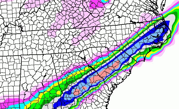
That’s showing more than a foot of snow for areas lucky to get an inch of snow in the winter. Talk about mass chaos… those southern folks would freak! 🙂
I have been yapping about the pattern for February having a wild look and I am trying to drive this point home much the way I was hitting this months bitter cold well in advance. The next few weeks will likely find us in a pattern featuring several storm systems riding in from the southwest.
These will be loaded with precipitation. For fun… check out the snow numbers from the GFS through the first 10 days of February…
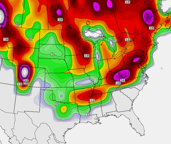
I am only showing that to show where the mean storm track is likely to set up. We will have bitterly cold air across the plains and Midwest with regular cold around here. Throw in a southeastern states warm up and you can crank out some BIG systems. The GFS Ensembles temperature departure maps (in Celsius) show that nicely before the bitterly cold returns… 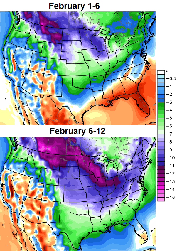
Buckle up for a wild month to close out winter!
Take care.

Wow! Thanks Chris. Looking forward to seeing your thoughts on the weekend. And for the next few days too.
you guys in the southeast of Kentucky
gotta love that snow map.
I kinda like this climate patterns today
it snows one day
melts the next day
then it snows again
Yea Chris I have family coming from tn Friday do you think we are going to have ice or snow Chris I hope you can answer my question…
So my comment earlier about WeatherUnderground and copious amounts of snow for next week was not as crazy as it sounded. Snow or freezing rain everyday from Sat to Sun. Up to 15 inches on the high side and 8 on the low. MIGHT get real interesting around here if all this pans out.
Gonna keep on thinking rain.
If the warm air had not busted the snow party this time much more than expected, I would be pumped- rare for me 😉 Catch is it DID bust the party, so have to consider it a factor. We all know if ice and snow are battling, which would probably win. Boo!
Rain would win of course by sneak attack LoL
Dang, how warm did it get? I feel like a goober now with all the shoveling I did. Any areas that did not have at least about 5″ of snow or shade are gone.
Students and teachers, best be getting into school mode! I would not have even thought saying this last night and be remotely serious.
Tell me about it. I plowed two of my lots that don’t report back until Monday morning. Wore myself when I really didn’t need to.
As a teacher I am so ready to get at least ONE day of school in!! And considering the temperatures forecast for Tuesday and Wednesday, we might only get one.
*sigh*
True story…same here. I think this blog is an unofficial teacher support group. Enjoy your day!
If school is in, there will probably be a lot of sleepy eyed students that were expecting to be off. The small snow CB talked about is the faint chance some might have in counties likely to have school.
All the surrounding counties have already called school off for Monday.Supposedly all this melted stuff is going to freeze before morning and possibly a bit of snow coming before daybreak.
I did a lot of shoveling because my drive is shaded.Thankfully it all melted after I removed the snow otherwise it would likely still be there.
Still would have had the drifts in the driveway, so positive spin is “only” 50% of my shoveling was a waste of time and effort. Did not expect this.
Looks like GA. And SC. Are stilling our BubbaBuster….That just doesn’t, get it…
The irony is too much. This means they are probably a lock for a big snow. Catch is they usually get the heavy kind that knocks power out if big snow.
Third attempt to post….hope your server is ok, Chris. Anyone know if there is any reason for Laurel County to not go to school tomorrow? (county roads not clear, possible overachieving frontal snow, upslope snow showers before school time?)
Server has had a workout this winter. I’m honestly a fool for not selling ads on this thing. With the numbers we do, I could do this and nothing else. 🙂
It’s true! Thanks for all you do…we really appreciate it down here.
I think you should. Really.
Its a shame that the deep south will get more snow in 1 event than i have seen all winter
Mmm-Hmmm
Is that a bullseye of 2ft over eastern ky or is it more?
Not sure I understand the “pattern” on that GFS snow map. I see the snow but don’t see the typical southeast to northwest track. Nevertheless, I’m very glad to see the southern jet coming alive. Of course, the Paducah NWS is talking mostly rain for this coming weekend. Guess we’ll see how this all plays out.
I would say i’m moving to Florida, but nowhere north of Key West is safe; and by the time I get theremI won’t have a place to park my car.
FWIW, the southern storm has been trending northwest with each run of the GFS since midnight
I was just about to ask if my eyes were deceiving me. I’ve noticed a bit of “want to” in a westward push of the precip in the past couple of days but really noticeable now in the past few runs. Might be more of an interest for those of us over here in swva but still probably something to watch.
Andy, notice how the light snowfall on the map above lays out? I know it’s basically nothing, but notice how it is showing snow to the west and southwest of Knox. To the North of Knox, and to the east and southeast of knox. Amazing how a map can make an upside down “U” all around Knox Co. Been that kind of year here and wouldn’t surprise me if we are not right on the snow/rain line with all these storms heading northeast.
just be a rain line 😉
NO school tomorrow Knox just called
Dang, wish I still lived in Atlanta. They are looking at the possibility of getting more snow than we have had here. However, on a good note, at least I don’t have to be on the roads there. I lived there during the ice storm of 2000 before the Super Bowl…..pile ups everywhere! Those people have no idea how to drive during inclement weather, whether it be ice or snow!
I find it strange the weather Channel isn’t in full alert mode yet since they are based in Atlanta, Jim Cantore can just film from their parking lot ??
lol. He sure can, except TWC is in Marietta (North burb at the Perimeter) and looks as though the track, in that map is from Midtown to the south.
Last map I looked at it was middle and south Georgia that will get the snow and ice.Middle Ga up to six inches,mostly sleet in the southern area and north Florida.Don’t think Atlanta is suppose to be getting much except cold temps this time.
There is an updated GFS run which shifted everything in that area North and West,
Anyone want to guess at snowfall tot as lsuren for Berea????
Just for fun of course ..
wow! looks like a really wild ride for the rest of Winter.
here’s hoping we can get one of those fabled old school snows!
thanks Chris.
So, I am wondering if todays temperatures help the front product more snow. Dewpoint is 30 and as that front pushes through and temps drop that could help snow output. Seems that when temperatures rise like this and then followed by much colder air we tend to get some form of precipitation. I also know that with the last few systems one overachieved here with humidity and dewpoints up. The others, basically nothing with the extremely low humidity and dewpoint.
I also wonder how school will go next week. I know some around my area think Monday is a go and looking out the window I have to agree. Still decent snow in the yard but the road is clear. Guess it depends how much, if any, snow we get here. NWS says the snow should hit around 6 a.m. with a temp. of 31. They expect it to be 18 by noon.
I like Chris’s last line “Buckle up for a wild month to close out winter”. Hope that is an indication that winter is going to go out when it’s supposed to this year. Had little to no snow last year, but cold and cool weather stayed with us up until May. Most of the time March, April, and May is decent temps with only a few days of cold here and there. Last year was cold and cool with only a few warm and dry days every week or so. I can deal with winter, just want my snows in Dec. – Feb. and then move on to spring.
Agree, lets hope spring shows up in early March and stays, a few more good snows and I have had my fill 🙂
temp never made it to 38 today here in athens oh ,only made it to 33 now 29
nice 5 1/2 snow fall on the ground as well
Shewww. Glad Kentucky isn’t in the deep south 🙂 I’m sick of snow!
Chris says the largest snows are yet to come 🙂
I’m praying that isn’t the case, keep that snow in Indiana and Ohio!!! oh wait… lets not forget Georgia 🙂 The only good thing about snow is snowcream 🙂
Winter storm criteria in Georgia is anything more than 2 inches, nothing to get excited over unless you live in the snowless south!
As long as those 2 inches stay out of my area 🙂
And you said i could have snow
yep, you for you, andy
Hi Barb,what part of the state do you hail from and did you get any snow?
Floyd county
Interesting how folks fret over model guidance and then take it verbatim if another location is in line to get a good snow.
Because for some reason it usually pans out 😉 Real mets have stated that the general Kentucky area is the most problem plagued for accuracy with winter events known as snow.
Rumour has it that the models are showing a big change in the February jetstream. Going from the predicted extreme cold to a more milder and normal scenario. Wondering if Chris is still on the extreme cold train? Would love to see more snow this winter.
That other station in Lex is on the rain train this weekend, 40s Saturday thru Monday with rain!
Can you blame them after today? Seems a fair estimate.
The southern jet is going to come alive with more warmth and precip working north. Cold intrusions will continue and somewhere in the “middle” will be a storm track with rain to the south and frozen precip to the north. Where that “middle” is going to set up is the big question. The further north you are the more likely you will be to see frozen precip.
John Belski throws hot water on a cold February, at least for now.
When you lose Belski, that’s never good.
He didnt really say cold cancel for Feb, just that the first week isnt looking as it once did. He basically talks about the subtropical jet getting more active, along with the cold shots still coming.
February will be colder than normal.
I hope you are talking about cold first half and a more normal end, which would still make it colder than normal. I’m looking forward to low 50, normal highs in the middle of February. Don’t want a repeat of last year when winter wouldn’t leave. lol
The NWS is good at predicting the weather a day or 2 in advance, but are not so good at it a week out. We’ve all seen that pretty much this whole winter.
Hopefully the higher than forecasted temps we got today will prevent us from going below zero tomorrow.
I still would like to know the accuracy of the Mesonet. Seems no way Johnson was zero last night and us around here were single digits to zero. Makes no sense for such huge changes from 30s and 40s to 0 and then to 52 without a significant system pushing it. Not adding up, especially with cloudy skies at night.
Seems not to be kosher IMO.
Like the Richmond reading showing ten degrees colder on a semi regular basis. If the average temp around that reading is much warmer, that reading then is biased and not an adequate representation of the area. More an anomaly or bad data point.
Chris, I love this blog, but can you please do something to clean up the language in the comments section? I used to let my son onto this page. No more. I thought the idea was to share weather reports and thoughts–not for personal attacks.
If you see specific instances…let me know and the person will be banned.
Jeff Hamlin says:
January 26, 2014 at 3:38 pm
Some people just have to be ignorant douchebags. They have nothing better to do with their lives than hate on others.
Jeff is one of the more sane folks, so must have been a pressure point 😉
Seems posting the exact quote is just as bad as being the original. Good intentions has that effect sometimes.
Who else uses language like that on here? Who do you think Anonymous was referring to?
The point was the language being read by kids. You bumped it up to current again.
And you are still defending it…
LOL Beth is obsessed with me.
Pointing out you posted it again 😉 I don’t even defend myself.
Hamlin likes to play internet tough guy sometimes, and his sacred cow attitude toward certain things can be annoying at times, but he’s harmless and certainly not worthy of banning.
As to the “keep my son off the blog” sentiment, I’m sure I could get an instant ban by simply quoting from the most popular book in the world. Perspective is important in all things.
LD I do not play internet tough guy nor do I have a sacred cow attitude about anything.
Give me a few minutes to get some quotes.
Radar looks juicy in northern Illinois, if this makes to KY and is cold enough for snow, Overachieving event possibly!
Wouldn’t be surprised if at least mid to late February doesn’t trend warmer. Most of the time things average out pretty close to “normal” and with a cold January I just don’t know how long it can last without us going above normal for a stretch.
You need to focus on what’s happening in Kansas City. We usually get what they get
Laurel County, and most everyone else along and east of I-75 is out of school tomorrow. I guess we may go back on Thursday????
Temp went down to 36 in frankfort, now back up to 37 with clouds moving in, looks like it will be a rain to snow shower event later tonight!
Seems like some different thoughts out their on weekend event and temperature and precip types? Sounds like normal KY weather which is rarly normal 😉
Nam completely loses any precipitation for Kentucky tonight.
Very interesting, since Jackson NWS just said a better chance if snow for east ky tonight, 1 inch totals will be common!
GFS still has it and looks like it even strengthened some in northeastern KY.
Temps spiking yet again, up to 43 now in frankfort, up 7 degrees in half hour?? I guess it wants to finish off what little snow we have left!
End of week and next seems mainly mix and rain. If we did not have the big warm spikes I would be more optimistic. The good news is less chance for ice now.
CB, if the models understated the temperatures bad this time, seems for short term they are likely to do it again.
Referring to systems with precipitation.
Hey Chris – moved from KY to SWVa and still love following the blog. More often than not, I can get a better weather forecast from you than the guys out here. Anyway, any chance this storm hitting the south has a chance of moving to the west some and hitting us here in the Roanoke valley area…more specifically Blacksburg? 🙂 Moved to the mountains, and have yet to see a decent snow…
Just some fyi…..the NWS currently states a high of 35 degrees today (Monday) and dropping. I hate to tell them that it is 48 degrees currently, making that the “high” of the day unless the temp goes up again. lol
What part if the state are you in? My weather app says I’m at 44, but my home thermometer is showing 35.