Good Monday, everyone. Our break from winter only lasted a few hours and we are now back into the thick of bitterly cold air. This round is courtesy of another arctic cold front diving through very early today. This will unleash another below zero night for many.
The front will have a narrow band of snow showers and squalls with it this morning. I’m not terribly impressed with this, but we could squeeze out a light accumulation across the east. The big news will be the wind and cold that follows.
Temps will start the day in the upper teens and low 20s then fall into the single digits during the evening. Wind gusts of 30mph or greater will make it feel much, much colder. Here’s all you need to track the day…

Current temperatures

Winds

Overnight lows will head toward 0 and below for much of the region. Areas along and north of Interstate 64 look to be the coldest with readings between -5 and -10. Wind chill readings may wind up at -15 to -20. Ouch!
Highs Tuesday will remain in the single digits for the northern half of the state with low teens in the south.
As we get the bitterly cold stuff… a MAJOR winter storm will blast the deep south. Anyone want to head to the beach for a snow chase? Check it out…
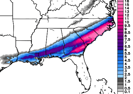
That’s impressive and will be a huge weather story. This just adds to the historical nature of this winter across the country.
What about for us?
I’m watching a system scooting in for Thursday and this could bring a swath of light snow with it. The pattern will then become very active with systems moving from the southwest into our region on a regular basis. The first will come over the weekend and could be messy around here.
One or two of these will likely smack us with some healthy snows as we head into February.
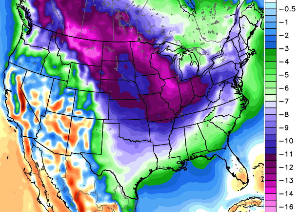
Speaking of… the models are growing colder and colder for the final month of winter. Check out the 5 day temperature departure (Celsius) from February 6-11…
 February is ready to rock and roll. Make it a great day and take care.

The ‘big bad wolf’ arrived just before 3:00am at my location near Louisville.
Winds were really strong. As a trained weather spotter, who has felt winds of 100 mph (with Hurricane Charley in Florida), I can make a fair estimate of wind gusts approaching 50 mph here in Valley Station. And it was not just one gust. There were several gusts like that for about a half hour.
And the temps are tanking. What a shock to the senses.
It’s at 25 degrees now as I write this comment.
Mike, our outside temperature appears to be sitting (best I can tell in the dark! 🙂 ) right at 32 and the winds are really picking up! You are right about the shock – I let the dog out and one of those wind gust just hit me full on and it felt like it was zero again! Poor dog turned tail and ran back inside too, after having voluntarily stayed outside for a greater part of the day today! LOL! He is even getting a bad case of cabin fever since his daily walks have been interrupted by this cold and ice. It will be interesting to see what we end up with during this coming round of winter!
Nashville TN hit 64 yesterday! It was easily in the upper 50s when I turned in. I’m also a trained wx spotter; I’d estimate a few gusts at around 4 am were around 40 mph.
It’s now 25 degrees.
Chris, as always, thank you for all that you do for us. This winter has been a challenge for so many in so many different ways – and based on this latest post, it seems that it’s not over by a long shot. Hope everyone stays safe and warm during the coming days and weeks! Take care, everyone! Have a great week!
It seems the front is getting here much much later than expected
Still in the 30’s in knott county this morning
Looks like Myrtle Beach will move ahead of Knox Co. for snow totals this year. Unbelievable. Lol
Thats happened recently cold snowless winter
Yeah, that stinks but hopefully our chances at big storm snows are coming. Of course, southern jet stream storms always bring the chance of it being too warm to snow. It’s always a delicate balance for good snows in KY.
Morning all. Thanks for the update Chris. Went to bed last night with it 44 degrees and woke up this morning to gusty winds and 30. Only gies downhill from here. Those poor folks down south wi really be shut down as they have no capacity to deal with much snow. Maybe that one is a hint of something coming our way before winter is done. (Always the optimist.) ;). Stay warm today everyone and have a great day! Thanks again Chris for all you do.
Is the snow on the radar hitting the ground? ?
It is pouring the snow near the Pike County line. Not sure about main roads but side roads are quickly becoming white…again!
Yes thanks so much for all u do…u have been the best weather dude for the winter…now just predict a long warm summer.!!!I have a pool…
No snow here in knott co so far but those winds are wild
Just read where NWS in jackson issued a WAA this morning at 3:36 for a half inch of snow and blowing snow..lol
that’s ridiculous
We aren’t use to that big of snows around here so they didn’t want to catch us off guard. 😉
I wonder how big of a snow drift we can get with a 1/2 snow…
3/4 inch drifts. Better get out the tire chains. Lol
so its past the advisory expiration and have not even seen a flurry.
With temps below 0 again tomorrow many schools will be cancelled once again. Wonder if the state could just declare it an emergency day or something since 90%+ of schools in the state will be out.
*Haven’t posted over the past week/half: have been enjoying the snow and cold!
Yesterday was nice to feel, but really would love a cloudy 28 degree BIGTIME snow! Chris is hinting that we haven’t seen the biggest snow this year and “One or two of these will likely smack us with some healthy snows as we head into February”…However we have to break the TREND of the SOUTHWEST…Just like yesterday the SOUTHWEST winds brought more warmer air than thought….Look at this weekend(first of FEB..probably 40 and rain). Lets hope somehow-someway we can get a southwest Jet Stream to bring a Big time snow, Heck GA, FL,SC and NC might do it, Hopefully we can!!!
Agreed. Cool if CB is right, but seems mix and ice have better shots of being main players for a lot of us. The warm air was a force that the models underestimated, so why would they not do the same thing just for the short term?
Very much agreed. I can see the northern half of the state getting into some more snow but if the trade off means we in the south getting ice Or heavy Rains I Hope THE Rest Of The Winter Is dry For All instead.
Buddy, I don’t even see that Ice/or mix will be a “Player”..I think it will be RAIN! At least for most of KY! Probably snow in top three NKY counties.
BTW, radar at this moment show snow for all of Madison Co,,,Must be up in the sky, cause its not on the ground. The V word!
Radar looks great here as well. Not hitting the ground though. Humidity 41% dewpoint -1.
30.8 as of right now here in Topmost of Knott County. I am sick of these single digit and below zero temps but I will not complain about the snow.
Snow this morning caught folks off guard here outside charleston. Dropped about 1 inch and got roads slick. They are now letting schools close early. Crazy stretch of winter
inch of snow and people go crazy…what is wrong with people these days
might have only been an inch but many roads in this area are still snow covered. On top of the ridge by my house there is still over 1 foot of snow. Most school buses were hours late getting to school.
weather apps like bing and weather watcher dont seem to show the cold for the pikeville area. then again, bing weather has never been in agreement with chris. however chris has always been spot on!
Looks like my old stomping grounds in NOLA and the Miss. coast are going to get a half inch of ice and 3-4 inches of snow tomorrow. That will be freak out stuff down there.
Frankfort area went from a nice 4-6 inch snow cover Saturday morning to a few patches here and their by Monday morning, wow, Mother Nature sure knows how to spoil a snow party, Chris says more to come so let’s close out winter with a thumper!
Looks to get very interesting around the Ohio Valley over the next week. Have heard/seen anywhere from Cold Rain / Ice / Snow for most of Ky. Southwest systems with a East West flow will bring a major ice threat to someone. Hope we can stay on the cold side of things and not the cold rain side.
The trend says the fence shows up along the Ohio River with the misery of a Wintery Mix for most of Ky. Of course NKY will get snow.
THINK RAIN!!! Actually I really am for this week. Have to travel to Indy Friday-Sunday and would hate to have to cancel the trip for Snow Work.