Good Monday afternoon, folks. The powerhouse arctic front slammed through here this morning with highs winds, biting cold and some snow in the east. This front is slowing down a bit as it pushes to the southeast and it may be just close enough to bring a bit of light snow into the southeast Tuesday morning.
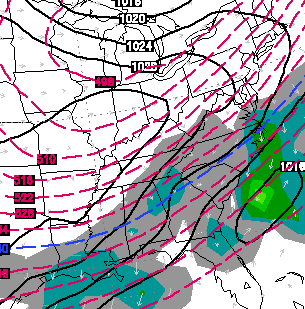
The Hi-Resolution NAM is showing this well on the simulated radar…
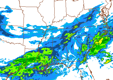
The Canadian Model is similar…
This means a couple of things…
– First, it could bring a period of light snow to our far southeastern counties.
– Second, it keeps clouds around much of the area and that is likely to keep temps from bottoming out overnight.
– Instead of 0 to -10… any clouds would keep us in the 0 to +10 range for many.
I will watch the late afternoon trends and have updates on that on WKYT-TV starting at 4. Take care.

Thanks Chris!
Hard for me to tell the difference between 5 and -5… Just sayin’… anyway, we are prepared for the cold now thank to the previous cold snaps. Everyone stay safe though, we aren’t through this yet.
I commute by bicycle to work everyday… here’s the difference… at five above, the warmth from my breath and salt in my tears keep things manageable. At five below my eye lashes freeze together and my breath forms icicles on my eyebrows and helmet!
Thank you for all you do to keep us updated!!!
I’d say school will be back in session tomorrow as well. ( for CKY that is)
Already is for most schools. But I’d say most schools will be out tomorrow. CKY will be closer to the 0 than that the 10.
Yep, Fayette County is back in today, but with a high of 1 at 7 and a windchill of -10 to -15 and a daily high of 12, I don’t see us coming in tomorrow.
I had three parents who walk their kids to school today, none of them dressed warmly enough for the weather so I honestly hope they call off for temps that cold! :/
I’m sure people will comment and say that is their problem, but many people don’t have the resources to clothe their kids properly. Not to mention if a bus stalls out on a back county road with no heat. Too many potential problems to have school tomorrow. I could see a few delays but even then there isn’t much difference between 7 AM and 8 AM.
Exactly! Our parents for the most part are doing everything they can to get by and I can’t fault them because at least they’re bringing them to school. We can offer the children coats (and have) but it’s still not really enough for these temps. And yes, having a bus wreck or stall would be bad on any day but on a day with those temperatures could be disastrous.
I wouldn’t mind a delay at all, at least the sun would be out, but definitely like you mentioned, so many potential problems to risk it!
I’d the temps were going to be as cold as thought they would close, but Madison had school on the day with similar temps for the last cold spike. Considering the amount of days already missed and likely missing a few more days for frozen stuff, it would seem a surprise if school is called off for non road related reasons.
Not saying I agree, but seems more likely with less cold temps forecasted. A wind chill advisory would make the decision a lot easier for superintendents.
Or whomever else makes the call for counties.
Weird that typo corrections I made are in another reply post. Phone posting sux lemons.
Good to know that this “artic outbreak” is probably not even going to be as cold as what we had last week. Still going to be cold, but if we can get through a couple of more weeks, the brutal cold chances will go way down. Average temps are on the rise and I personally cannot wait until mid February get here and average highs get into the 50’s. I would take a dome buster though. lol
Depends on location. Despite the slowing down of the cold front, there still will be areas to the north where skies will clear tonight. If so, the temps there may still go well below zero.
Perhaps one factor that might keep things a tad “warmer” is that much of the area’s snowpack melted when temps spiked unexpectedly high yesterday. However, CVG airport in northern Kentucky is still predicted to tank at -8 overnight.
Thanks for the update;
I wish it would have put the brakes on earlier (sit us all in ky at 28 degrees, then low come up from gulf and give us something to talk about!….
This makes more sense considering the huge temp delta not picked up by the models already for the weekend and the system delay today.
Will the models correct, or will they continue doing this? Makes met jobs even harder than already are in this state.
I’d = If
close = closed
Speaking of a “Wind Chill Advisory”, why does most of East & North Kentucky have one right now while Central Kentucky does not. Seems like temps will be pretty similar (winds too) in these areas tonight into tomorrow.
Was wondering same… Perplexed by this since i saw the map this morning…
just shows how unpredictable forecasting the weather can be …. its just a hi-tech guessing game and some are better at it than others …and for our benefit CB is more right than wrong
You know what else will help keep the temps warmer? An almost complete removal of the snow pack that was in place. Remember all the on-air talk during the 27 live coverage Sat.morning about how ” the high impact snow coming down will be with us all week on top of the snow we already have on the ground.”
Anyone who watched it had to be scratching their heads just a couple hours later as the sun and temp spikes cleared away most of the snow by 1-2 PM the same day and then just kept on rolling on Sunday. I’d love to see a scientific autopsy post on what exactly happened. Those were a welcome part of the original WKYT blog and the first few years of this site.
Even the warming channel was too low for temps yesterday. I hope that forecast temps miss again tonight. Big difference between -10 and 5 above. I like that CB is seeing things not getting quite as cold as first thought. I would like to see a dome buster, but don’t need -10 temps for that to happen.
Temperatures are already at 18 at Lex. NWS had the high at 13 for today. This unexpected warmth may indeed preclude us from getting below zero tonight!
It would be an interesting betting line that’s for sure. Set the line at 0 and predict over/under. I think Lex gets close, but areas north of 64 will be right at 0 or just below.
Perhaps the domino effect due to warn air could also impact precipitation at the end of the week and onward……
A cruel last laugh from the Torch? Sure it ain’t a 50 plus degree average, but the 50s sure spoiled the snow pack and forecast party. Word.
Question? If this front stalls out too much, and slows down way more than expected..Then what is the chances of that gulf moisture thats going to slam the south east states moving more NW??? Just wondering here, long shot???
Well, that depends….if you live anywhere around Corbin, Somerset, Barboursville…………..NO CHANCE!
LoL
Adam, I was thinking the same thing! I suppose stranger things have happened!
Well, that sucks.. i was looking forward to some sunshine the next few days..
Hello
Strange as this may sound, despite the cold and the snowy periods we’ve had, it still feels like most of Kentucky has been left out of the fun. We missing the signature storm that would make this winter truly one for the record books. Maybe it’s just me, but clippers aren’t big storms.
We are sitting at less than 3 inches on the year in Knox Co. Saturday was the first snow of the year that had been greater than 1 inch. Hate to think with all the arctic cold this year that it will be on the low end for snow amounts. We have about three or four weeks before I personally want winter to be a thing of the past. Once we get to March, I start watching the forecast hoping to see 60 degree temps.
I here ya bobt. Same here in Laurel County. I am pretty much on the Laurel/Whitley County line. Makes me sick to see it hitting all around us and we get NOTHING. I am almost in SUMMER MODE if this is what we are going to have for winter. 3 – 4″ all season long is ridiculous.
I am hopeful that spring tornadoes are not bad this year!!!
I also wonder about the effect of this pattern on severe weather season. Any of you more-qualified folks care to weigh in on that?
Let me get this right. Lots of snow has fallen in Northern Kentucky northward into Canada. Now there is a snowstorm moving into the deep south and accumulating at that. Here in South Central Kentucky…….NOTHING! This is insane. All this cold and ABSOLUTELY NO SNOW on the ground. How is it north and south of here gets DUMPED and we can barely get an inch from time to time?
SOUTH CENTRAL/ SOUTH EASTERN KENTUCKY this is the new norm for WINTERS! ARGGGGGGGGGGGGGGGGGGGGGGGGGGGGGGGGGGGGGGGGGG
Schools closed today with no snow on ground? CRAZY!
The warmth this past weekend REALLY took a TOLL on the snowpack. The once 6″ of snow in my yard ALL melted yesterday. Now the NWS doesnt even have us going below zero here in Lex at all! So much for the 4″ storm on Sat only to melt the next day. *sigh*
With little snow pack on the ground after saturday * Sunday’s high temps. I don’t see us going below zero tonight, even with a clearing sky.
Going into February looks to produce more drama for the region. Other mets are starting to jump onboard.
Hopefully they are correct. Next weekend looks real interesting. Of course that is a week and five days away.
Dodger says look at that winter storm in the deep Deep South. If the coming southern jet storms miss us to the north, Dodger gonna be super &$/%#¥€< not happy!!!
Release the Kracken!
Of course that winter storm in the deep south is an “ankle biter” by Bubba’s standards. Most of the winter storm warning areas in the 1-3 inch range–some just for a light mix of ice and sleet.
The state record for snow in Florida is 4 inches–I think that is safe.
……… Release the Kraken anyway!!
A lot of the state still has not got a decent snow this winter. Let us release our frustration as vengeance just like Liam Neeson did! Go get em’ Dodger!
http://www.youtube.com/watch?v=7SqC_m3yUDU
NWS starting to sniff out a SE KY light snow for Tuesday. Wonder if this will amount to anything.
http://forecast.weather.gov/product.php?site=NWS&issuedby=JKL&product=AFD&format=CI&version=1&glossary=1
On the 18z GFS and NAM runs it looks like the GFS increased the snow while the NAM decreased. Not surprised since it seems like those two models are always opposite.
Here’s hoping for an early spring. Hope things dry out a bit too
most schools around here are planning on being in school tom! Bundle up your kids in the morn!!!!!!!!!!!
Madison has school, but a two hour delay due to no wind advisory. No snow pack or clear skies as CB stated equals about ten degree less cold.
we still have snow on the ground here and we are under a wind chill adv here until 1 pm tom. We got abt 7 inches of snow on Sat alone, and had 5 inches just before that so still have a good snow pack left, Our temp is down to 10.8 deg at my house currently at 9pm, We shall see how things look in the morn, but at school today they said we would be in school on norm time.
wind Chill advisory
Looks like almost all schools here in wv have called off school for tomorrow,
so I am boggled by the no wind chill advisory for CKY. anyone have any thoughts on this. the wind will push wind chill into the negative territory but no advisory?
The wind chill has to be forecast to be -15 to -24 with at least 10 mph sustained winds to get an advisory in Central KY. -25 or lower brings a warning.