Good evening, gang. Bitterly cold air is back in the bluegrass state as readings head toward zero or a bit below for some. Wind chill numbers tonight will drop to -10 for some areas. Brr! The pattern going forward continues to look super duper busy.
A winter storm will hit the deep south over the next few days. That’s a crippling storm for millions of people. We could see a touch of light snow graze southeastern Kentucky on Tuesday.
The pattern revs up later this week as we get ready to track a series of storm systems… the first few look messy. Number one arrives as early as Friday…

That brings a wintry mess through the weekend and may have a bigger system waiting for early the following week….
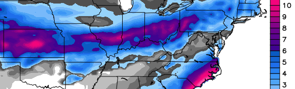
GFS 8 day snowfall forecast:
Watch the models grow colder over the next few days as they get a sense of the amount of arctic air across the country.
Moral of the story… February is likely to bring a lot of nasty weather our way. To repeat… I do NOT think we’ve had our biggest snow, yet.
Take care.

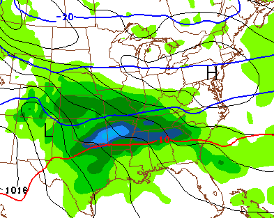
See that 1 little gray dot down in southern KY surrounded by all the bright colors? That’s BG. Can someone explain why we never get snow? Lol or even why a prediction would look like that with a small circular area of very little snowfall? What makes the maps show this?
It’s actually probably a good thing not to be in the bullseye this far out. It will change a hundred times.
At lrast your on the darker gray and not the almost white gray
Thanks Chris. I feel for those folks in the Deep South that are even less accustomed to snow than we are. They will be paralyzed! Maybe we can get a southern storm to hit us all in good old KY before winter is done. Just one big one for everyone, please!
My baby sister told me that the local mets are predicting up to 2 inches of ice and 3-4 inches of snow. She lives in East Texas. They have nothing but pines. Can you imagine the mess that could create?
CB, I admire your defiance of the evil trend! Some of us technically got a biggish (though short lived) snow via two several inch events. (Richmond 4″ + 4″) Those of course drifted anywhere from .5″ to 24″, depending on what stopped the snow blowing around.
That lasted as long as snows to our south do. About a day for the total accumulation. I guess the snow figured, better to burn out than fade away. Must have been a Neil Young fan 🙂
Still hoping for that “BIG one.” My 11 yr old twins think these ankle biters are awesome. SAD! Lol
appreciate your dedication Chris.
I’m wishing and hoping for the BIG SNOW too…. looks like we have few shots coming into February!
and some of the stats folks can tell us more but it seems like February has been a pretty good snow month in the past.
The GFS and Euro are very wet! We seem to be going into a warmer, much more wet pattern with cold shots. GFS has been giving us TONS of moisture whether it be snow or rain, and yes, it does give us a lot of snow snow but cold shots are not as long-lived as these past ones. I have to agree with CB that I dont think our biggest snow has fallen yet. (Hope he’s right) This pattern is ripe and loaded with heavy snows, just dont know where they’re gonna set up.
Do you any hope that we will get some snow in Todd County with this upcoming system?
Chris, when on Tues. is southeast Ky suppose to get snow? We have no school again tomorrow, but teachers are reporting. We still have roads that are bad from Sat. storm. Didn’t melt any today, and sounds like it will not melt much tomorrow either. Thanks for all you do. I love this site, I check it several times a day for your updates.
The system that going to hit the deep south keeps trending N/W on all the models..Nothing for Ky but like CB said far south eastern Ky may get a graze..If models keep this up then the precip may increase..Anyways something to keep an eye on in the Southeast..
The other thing to watch for is the dreaded Southeast Ridge. If it shows up, some say it may, it will really put Ky on the Fence. But before it comes we have to deal with Ice. I see Ice in our near future….
I’m afraid the fence line is going to come into play again. Like the post above, CB indicates a wintry mess. For the last 15+ years, Kentucky has been a transition zone for a lot of big snows. Seems like we are stuck in a cycle of rain with left over snow just before the system exits. We need a dome buster, or I say let the groundhog see the shadow.
Fence dont affect is it will just rain;)
Fingers crossed that the coming systems find their way through the TN valley and not the Great Lakes!
I’ve had enough winter. You’ll thank me when the heat bill comes in! 🙂
Nope natural gas gas wellhope winter lasts forever 😉
What?
I read that Charleston, SC is under an ice storm warning for up to .50″ of freezing rain. There will be lots of new palm trees to see this summer. My family in Charlotte expecting at least 3 inches of snow. Maybe that system will graze us a bit and hopefully this weekend will be snowing or sunny. Extreme arctic cold has lost its novelty. Time for daffodils. Everyone stay warm tonight 🙂
I picked a fine time to travel to Savannah
00Z GFS trends toward the NAM in bringing swath of light snow to southeastern Kentucky, with temps as cold as they are, would not be surprised to see up to an inch, possibly squeezing out 2 inches in higher elevations
I tried posting this about three or four times but it wouldn’t post. Looks like the GFS and NAM are spitting out between 0.10 and 0.25 QPF for areas around Harlan and Middlesboro. Could be interesting. With the moisture coming out of the south/southwest it should moisten up the atmosphere a little better shouldn’t it?
however, the cold dry air could play a role, as in past systems, and prevent the snow from reaching the ground
I dunno..If i’m reading it right looks like RH is gonna be pretty high tomorrow..Could be a nice little surprise if we keep getting more interaction between the northern and southern stream which creates more lift..
00Z NAM
http://grib2.com/gis-snow-overlays3.php3?BASEHR=00Z&STATIONID=JKL
18Z GFS
http://wxcaster4.com/gis-gfs-snow-overlays3.php3?BASEHR=18Z&STATIONID=JKL
The 00Z is looking similar, but is not fully through yet.
The snow in the northern part of Kentucky on the GFS must be for 4 or 5 days from now.
Charleston SC looks to get a bad ice storm on latest run..Looks like maybe .75 qpf..
00z gfs is odd with the next system. Starts out as light/moderate snow early Friday in central kentucky then changes over to rain as a stronger low takes over. Might be one of those dynamical cooling situations where central kentucky gets a wet slushy snowfall.
Looks like we are in for a few rain storms over the next two weeks. Most if not all the models are taking the upcoming pattern to the northern tier. Then it will get cold with another DRY arctic blast. I did say DRY.
Now that they have all waffled to the North lets see if they can waffle back to the South over the next few days.