Good Tuesday, everyone. We have a bitterly cold day in progress across the bluegrass state and a few spots will have to deal with a bit of light snow. All of this continues to be part of a nasty winter across our region and for much of the country.
The batch of light snow looks to be confined to southeastern parts of the state and could leave behind some light accumulations. Here’s a look at the areas most at risk of seeing some snow on the ground…
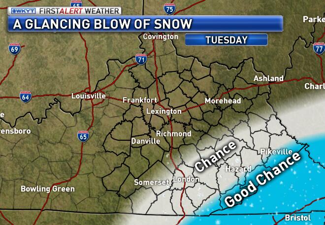
Here’s regional radar to track the light action…

Temps will continue to be the big overall story of the day. Readings this morning will range from -5 in the north to 5 or so across the south. Gusty winds will make it feel -5 to -15 degrees at times. Highs today will reach the low teens in the south and high single digits in the north.
Today’s lows

Current temperatures

From here we watch our weather pattern kick it up a notch and that’s saying something this winter. We are going to see a series of systems impact our region over the next few weeks. The first one arrives by Friday and carries us into the weekend. This looks messy with snow and rain and a mix at times. We will see how it plays out as we get closer.
The next system has more potential early next week. The GFS continues to be a colder model that puts us in line for a lot of wintry weather over the next week to 10 days…
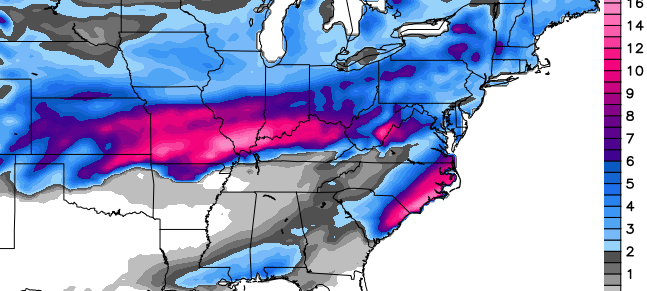
The Canadian Model tends to wrap systems up a little too much. In doing so, it takes the heaviest wintry precipitation just to our north…
UPDATE… the new European trumps the GFS…
We will have NO shortage of winter storms to track in February. As I have stated before… get ready for a rock and roll month ahead.
I will update things later today. Take care.

Lol, Canadian model picking up the doughnut hole (AKA Dome) over CKY. Spot on!
brrrr…wish old man winter will wake up and quit snoozing and move on lol i think all this cold weather will do good for the ground puts nitrogen back in the ground kills of some bugs like fleas ticks some mesqueitos and never know might make them fish bite a little better this year…ty chris
Once again temps much warmer than expected here. I hope winter storms actually mean snow and not rain like the 1st part of winter
Thanks CB! The catch of course for Fencetucky is if any of those potential coming systems have the words “ice”, “mix” and “rain” attached to them 😉 We know what most of the precipitation form would likely be if those words are part of it and sadly it is not “snow”.
Not until the Monday system. I believe the set up will be of the norm around here with the FENCE setting up along the Ohio River. I am traveling to Indy Friday-Sunday. Looks to be snowy, I will try and drag some back with we.
Very cold here this morning.The thermometer on the back porch is on zero.Water pipe almost froze.Turned it on to barely a trickle.Left it going and it finally ran freely.Have my pipes wrapped but there must be one spot that is out of my view that isn’t wrapped well enough.
This winter is draining me emotionally and its not helping the ole checkbook either.A cold day here and there I don’t mind but the duration of it this winter is wearing me down..My boohoo for the day.lol
11 here in Carrie of knott county this morning .
Thanks Chris for the update. These models are going to waffle for the next four to five days. Just yesterday the Euro looked like the Canadian and the GFS was 100 miles to the north. Anyway you look at it we are in for a wild ride over the next couple weeks. Hopefully the cold air wins out this time and we get snow snow snow. Have a great day everyone.
THINK RAIN!!!
Thanks Chris. It’s 4 degrees and cloudy here this morning. Got enough layers on to dress two people as I head out to work! Next couple of weeks look interesting for sure. Have a great day everyone and stay warm!
Watching the wkyt 7 day this morning it was good to see we are getting back to normal. Below 32 dry, above 32 wet. Back on the fence again.
But as usual we are on the wrong side Bob
Glad the models were a bust on the arctic temps. Only a few northern counties got below zero last night. For those concerned about SE Kentucky having snow this year, today’s system looks to stay well south of us. Andy we could drive south today and see snow and head up north this weekend for some snow. Guess we can say not a far drive either way to see the snow. Its always all around us. Lol
Some of us need the Euro to be right so some of us can get close to normal snowfall for the year
Thanks Chris. We love your updates and how well you keep us informed. It sure is a cold morning here in Berea , and I dont see it getting much warmer after our schools 2 hr delay. Keep up the good work
I’ll be in Knoxville today, so I’ll at least get to see some snow!
Low of 5 this morning.. Clouds from the southern storm must have helped. Clearing tonight, though. Wonder how cold we’ll get?
Almost hit zero this morning. 1 degree higher than the forecasts for my area. No school. Wondering about tomorrow. Was told they are going to delay 2 hours which is fine. But tonight is forecast to be basically as low as last night which means the morning will be just as cold. Roads are clear so it was not the roads. Wondering if they actually go through with the delay or actually cancel outright.
Cloudy is the forecast for today with a high of 13. Looking at some hourly forecast it seems that mostly cloudy for today and then clearing starting about 9 tonight. If the clouds keep temps down and it clears tonight could bottom out lower than this morning.
Good thing my heating fuel ran out early this morning. We are on the list. Have been for a long time as I checked and ordered before the first arctic outbreak since I knew it would take them a while. They were filling those who where out first for obvious reasons. Now, they cannot deliver because of “icy roads” that have been clear since last week. Oven and electric heater did conserve some and made it last longer. And this is weather related as I am afraid it might snow in my house tonight. Or at least get a nice arctic frost. Gonna have to work to keep the pipes from busting.
As for the snow down south I wonder how that effects temps overall. Would think that would keep the southern air cooler and help keep our temperatures down a little. The way Kentucky weather is though it is hard to tell.
Hope everyone has a great day. Thanks Chris for the great blog. Looking forward to your thoughts on how things play out this weekend and next week. Really hope we see less arctic type air and maybe just a nice cold snow. No ice.
I expect mainly rain this weekend BUT as Mr Fudd would say, “next week could be ‘bery inta-westing'” 🙂
Yeah, that 2 hour delay for Madison was certainly helpful. 1 degree warmer and the wind chill virtually unchanged.
I know. If they do a delay here tomorrow it will make no difference temperature wise. Might as well go on time.
As for the wind chill the NWS for my area said that they are cancelling the wind chill advisory. Says the advisory was lifted because wind chills were not at advisory levels. I know for my area they predicted a wind chill of -10. Right now it sets at -8 and this is after a 1 degree warm-up. And we had been in that advisory. Where my mother lives was in it as well and they are now at -9 wind chill. Was forecast for -12. So some of these areas maybe should still be in an advisory I would think. Of course it makes no difference. Still just as cold. No need to tell me.
Ain’t no delay tomorrow so far in Madison. It could be 5 degrees colder than this morning, but no delay yet. Real good Madison county. Winning! Not.
“get ready for a rock and roll month ahead”…I just hope this isn’t the high’s and low’s based on watching the models. I hope its Chris’ thoughts that we are going to get bigtime snow!
I really don’t care to just watch models tell me its going to snow and then to fail!!!!
Would like to hear Chris’ in depth thoughts for next weeks snow potential. He correctly forecast both arctic outbreaks nearly a week beforehand. I’m just wondering if the set-up is there for something major around these parts next week. The longer range on these models just increase peoples’ hopes for snow only to crush them in the end. The next major winter storm is always one week away.
Also, the current storm in the SE has trended to the North and it seems like that has been the trend for sometime now. Chris, do you see anything in the models that point towards a track favorable for major snow in this area? Or will areas to the north keep cashing in this winter?
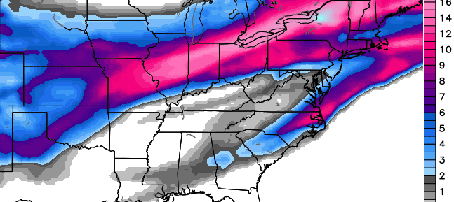
Both the Euro AND the GFS show a snowstorm next week around the Tues-Wed time frame for ky. But we all know this is probably model fantasy and the track will shift north, just want a really good dome buster. Hope the models are on to something…
I would love to see the Euro verify. It has been a long time since the Huntington area has received over a foot of snow in one storm. However, the models seem worthless on a storm track until 60 hours out. If conditions look favorable and the storm continues to be in our vicinity on the GFS and Euro throughout the week, I may have some hope for this one. Seems like this should be the winter to break out of the pattern we have been in. Still holding onto some foolish optimism
thank you Chris.
very cold -1 by my vehicle thermometer. just seems colder today.
Bring on the big SNOW, looking forward to what the models and Chris hash out for next week.
which model has been most dependable this winter or is it a wash?
Officially 0 this morning in Lexington. 5th day at or below zero this month–the record is 7 set in 1970 and 1977. Ironically, we’ve had enough warm days this won’t finish as a Top 10 coldest January.
The Torch got the last laugh. Though lost the January temperature war, winning this last battle was a snow melting killah’. It appears to also have collateral damage for early February too.
the thoughts are always a big snow or more snow …but for different reasons it never seems to pan out
Got my daily dose of pessimists today. Keeps me on my “fence” 😉
I work outdoors and today seems about as warm at 14 here as yesterday did in the 20s. No wind today makes all the difference
It’s interesting to see that some parts of the deep south are going to get a larger snowfall than most of KY has had all winter, it only takes one or two cold spells down their to give them a Epic event, we have muliple Epic cold waves with small snows at best, something’s gotta give us some snow love one of these days??
Very few parts. We’ve had about 8 inches this month in Central KY. I would doubt many folks in the deep south will get that much. Now, if was in Southern KY, I’d be upset!
I’m mean in one event, I see some areas down their are in-line for 6-10 inches of snow, that’s even more than our northern KY snow belt has gotten in one event!
Feb 9-10, 1973 was one of the bigger snow storms the south has ever experienced. Augusta GA, Columbus GA and Auburn AL all got 14 inches. Macon GA received 16.5. Even bigger amounts in the Carolinas.
Interesting link (here) about southern snows of the past.
Unusual winter for many, not just in our region. Even areas that do not get large snows are in for a wallop.
And it’s not just about the extreme cold and weather conditions. Alaska has had extreme warmth.
Seward’s 61 degrees yesterday matched places like Atlanta and Houston.
I’ve noticed even Barrow has been warmer some days the Central KY. That’s crazy!
In DJF, I pay the $20 a month or so to read and watch Joe Bastardi’s thoughts. So today I watched his video with great interest based on the maps presented here. Needless to say, I hope the GFS and Euro are right on the money. Having said that, and maybe I’m not understanding fully what he said, Bastardi indicates the upper air pattern is more suggestive of a lake cutter, the bane of Kentucky’s existence.
To be sure though, this has been a winter unlike any we’ve experienced in 25 years or more so the usual misses may not be the right way to go. Having said that, the atmosphere has wanted to snow on us this year, but only lightly (clipper mania). The real axis has been Indy to Chicago and that makes me wonder if the cutter idea is probably where this goes.
with southern systems–lake cutter is a great bet. Because the trend for southern systems is actually a cookie cutter for this area.
On cue, the new GFS looks to take the low for the storm on or around the 5th right over the top of Louisville.
booo
What do you mean by lake cutter?
A storm that begins in the southwest and tracks towards the Great Lakes. That leaves Kentucky and Southern Indiana on the warm side of the storm.
Ok I see. Hope that’s wrong and we do get a good snow this year!
it was -1 deg here this morn, we have had colder but still cold enough, all the schools around here had planned on going to school today but most had to shut down due to water mains breaking,
Lucky we didn’t get the -10 to -15 as advertised just a few days ago. Still very cold out, but 0 degrees a lot less damaging than -15 below. Maybe we will get a dome buster, but it just seems like we are still going to be a transition zone for the southern storms. Amazing that Georgia can get snows out of these systems, but we have not had a good one hit in over 15 years.
Seems like our cold is always retreating when we get moisture to come our way, we rarly have fresh cold fronts coming in with arctic air the same time the moisture comes in, we need a arctic front to stall in southern Tennessee or northern Georgia and then have a low pressure ride right along it!
The power is the 33 degree rule is formidable. So much so, when we do get a decent snow, the warm air finds a way to melt it in 24 hours and THEN get cold again. Uncanny.
I Know right, Sunday blew my mind how warm it got after most areas got their best snow of the year, a warm up Saturday coming with rain only to see it get colder Sunday with I moisture!
NO moisture 😉
It was Richmond’s best snow in five years (counting the two 4″ snows together that accumulated). The only thing left now are the big drift areas and snow piles.
Just talked to my folks in the Chattanooga/Cleveland TN area, they have been getting moderate snow there. Mom has a snow day.
I’d hate to have to drive up Lookout Mountain today 😉 .
My brother in north Georgia is also reporting snow there as well.
Temp map is wrong. 22 degrees here in my part of Knott county.
Try to go to the mesonet site itself sometimes it doesn’t refresh here
I just checked it does show 10 and its line with the rest of the area
Showing 21 here in knott co bob
I think we must be accurate then lol!
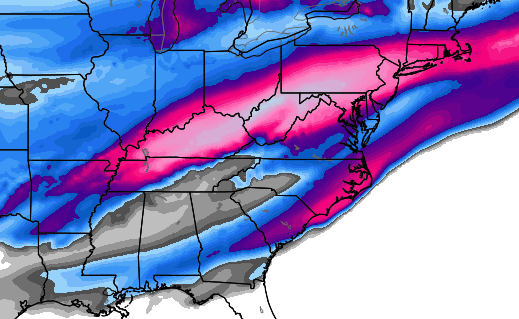
According to the maps on Weatherbell, the GFS and the Canadian both track the heaviest snows from Indy northward on the 4th and 5th. The low on both tracks almost directly over Louisville and the temperatures look like they could rise well into the 50’s if not the 60’s, at least briefly. I’ve not been able to see the Euro maps yet. I guess Indy’s the one in line for the memorable winter for snow, at least so far.
The T word supports this path since played out this way all winter for most systems.
People are envious here, but snow has gotten very old to most folks that keep getting it. I look at snow like a tasty cinnamon roll. Tastes great, but gets old real quick….. Cinnasnow.
We are talking about a system that is a week out and has made land yet. The models will continue to go back and forth with this until probably Monday. But if I had to look at something long range, I would use the Euro. It has been the best in that area so far this winter. By the way, the only long range foecast that has really verified is that of the Farmer’s Almanac, and it says that February will be the most wintry month for our area.
hasn’t made land yet… sorry
See the thing is, if it comes from the gulf, it usually goes to the right or the left of the appalachians. Rarely, does happen but rarely does it go up the spine. With counter-clockwise rotation, it will pull warm air into parts of Kentucky. We get decent snows if they track up the east side of the appalachians or move up the coast. Then moisture can spill over the mountains into East Kentucky into cold air.
If they track the west side of the appalachians, then warm air *can* nose into East/Central Ky and Louisville can get good snows.
That is why clippers are usually better for East Ky as they hit the appalachians and dump snow as they are lifted. (upslope)
The snow is picking up here in Harlan County; it’s sticking on porches and cars, and beginning to stick on the ground as well.
Radar looks promising right now, but snow not making it to the ground in Knox Co. Par for the season.
Snowing here
Snow looking closer to Clay County on radar, but now snow falling yet. How long has it been snowing in Knox Co.?
Maybe 15 or 20 min i suppose its really light and really fine
Keeping my fingers crossed for a BIG one to hit! I WILL not give up hope!!!!! lol
I have hope as well. Looking at the models there is something big showing coming up. Actually looks huge if it pans out. But that is out to next week and things change so fast. Still, hope is there and I will cross my fingers with you.
Cannot wait to hear what Chris has to say about the upcoming events and how he sees them might play out.
starting to flurry in London.
Joe Bastardi said February looks to be the worst winter month.
The problem with him is he’s so east coast focused. I watched his video this morning and most of his comments seem aimed at the “snow geese” in the northeast. In all of my years reading his columns and watching his videos, I can think of just two or three times he’s directly mentioned our area.
And his view can change on a Rolo dime. Speaking of Rolo, where is the Goat Whisperer?
Quit subscribing to Bastardi a few years ago. Never could figure out why he’s so in love with himself. Weather Channel, Accuweather…all of them pretty much ignore our area anyway.
Agreed on Accublabber and Warming Channel.
If it makes anyone feel better about Kentucky’s snowfalls a lot of time, the Carolinas, parts of GA, and AL are having their forecasts busted by dry air as well; they have a much lower frequency of wintry events, along with a closer proximity to moisture. The impressive radar down south is largely going to moistening the atmosphere, the dreaded virga. Would suck for this to be your only chance at a snowfall and see that happen.
That being said, Atlanta and a few other cities have overachieved with a few inches and things are absolutely shutting down in the area. Traffic cams out of Atlanta are crazy, 30-min commutes taking 4 hours.
Anyway, here’s hoping we get our own snowfall in the coming weeks!
Just made it home from Knoxville. Knoxville is a mess….several inches of snow in several areas. Roads getting nasty with heavy snow now falling in Middlesboro now with nearly 2″ so far. Looking at the radar, we get up to 4″ out of this!!!
Snowing again, coming down lightly, my road is already covered. Sick and tired of snow! GRRRR
tired of August too much heat I cannot get out of my house.
my air conditioned bill is too high. mosquitoes are biting my legs at night.
deal with it
there is only one more month to go. the lifespan of a butterfly.
Snow likes you Barb, might as well make friends with it 😉
I am glad you folks n southeastern Kentucky r picking up you’re well deserve snowfall.
I thought we deserved more than just some light flurries.
Thanks!!! About 2.5″ here in Middlesboro. Hopefully, the entire state, including Andy and excluding Barb, will get “the big one” before the end of winter. Then everyone can be happy!
Noticed driving around the hood today in frankfort, the north sloping yards still have plenty of snow in them, south facing not much at all, but some areas still very snow covered!
It is snowing to be the band in Pikeville.Roads are bad.
Where’s Mr Bailey with an overdue update? We’re spoiled 🙂
Weather’s boring right now. Let him rest.
Boring? NEXT WEEK could be anything but boring around here!
Unless the main performer is Sir Mixalot 😉