Good Saturday to one and all. We continue to watch round after round of light snow working across the bluegrass state this weekend. It’s the winter that keeps on giving… kinda like the jelly of the month club. Additional systems will carry us into next week and these will try to become bigger than what we have now.
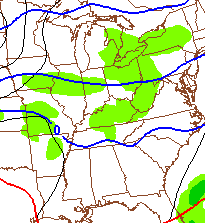
The first band of light snow rolls through early today and will put down some accumulations. Areas along the Interstate 64 corridor will be looking at under an inch. Farther south from there… around 1″ will be possible. I do think areas of southeastern Kentucky can pick up a couple of inches from this. That includes some of the spots that have missed out on the recent snow and ice.
The models indicate another round of light snow working in Sunday, but differ on when and how much. The NAM is a bit weaker and earlier in the day…
The GFS has more of a wave of low pressure rolling across the Ohio Valley during the afternoon and evening hours…

Either way, it’s a safe bet that you see more light snow on Sunday with minor accumulations possible. This is where we get some bit disagreement among the models. The NAM continues to track a decent snow system through here…
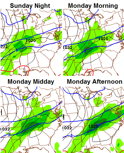
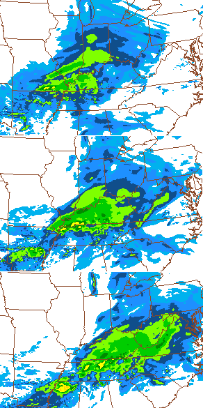
It has the backing of the Hi-Resolution NAM. Check our the simulated radar into early Monday…
The Canadian Model has something, but isn’t nearly as strong as the NAM family…
The GFS does not have the Monday system and keeps it scooting along to our south and southeast as VERY COLD air settles in instead. The GFS suggests 0 or below would be possible by Tuesday or Wednesday. The NAM also gets around to that kind of cold, but does it in a different way. We will have to wait and see about that.
As I have mentioned… NO system can be written off in this pattern. There is so much energy crashing in from the Pacific that the computer models are overwhelmed. The won’t latch on to some of these until a day or two before.
Let’s track today’s light stuff…

I-75 @ Winchester Road Lexington

I-75 @ Iron Works Pike Lexington

I-75 @ Clays Ferry Bridge South Between Lexington and Richmond

US 60 @ US 127 Frankfort

US 127 @ Frankfort Frankfort

I-75 at MP 36 London

I-71/I-75 at Buttermilk Pike Near Covington

I-64 @ 3rd St. Exit Louisville

Downtown Louisville @ 2nd & Broadway Louisville

I-65 @ 234 Near Bowling Green

I will update things later today. Take care.

Looks like Laurel County may get a little dose of snow. As my Papaw would say if things didn’t go your way,” maybe you aint holding your mouth right”
LOL! My Papaw used to say the same thing! 🙂
BOTS!
It has started to snow here in knox co.
WWA just issued for knox
Light snow is falling now.Can see some big flakes mixed in this time.Temp is 20 degrees.Just a dusting showing on the steps so far.
Advisory cancelled here In Madison county. Has this one fizzled?
Not a flake appear to have fallen, so the near usual yes.
The frozen slush and coating on top from the other day is holding on tough though.
and just think you guys had the advisory last night and we didn’t and we ended up getting the snow LoL. I’m sorry Bubba but i think i stole your snow 😉
Odd overall how for so many years we miss the big systems, but more odd to miss the mini ones. We usually get the drive-by snows. Your area appears to have taken the crown from closer to the river. We have not got much this year (or the previous two), but your area much less.
Little fish, smaller fish 😉
If it wasn’t so late i would have invited you for Concrete mixer at Culver’s 🙂
Speaking of, they have a great fish sandwich 🙂
Thanks i may have to try that.
Yes. WWA now only for southern most counties and they may not see even an inch out of this.
If that happens it would be the theme of winter. The winter that keeps om giving coatings of snow 😉
Still snowing lightly here.Looks like we may have gotten about a half inch so far.
Close to an inch here in Pike County and it’s still snowing moderately. However, no Winter Weather Advisory issued for us. I just do not understand this.
January “torch” – where is that guy? Wasn’t he saying average temp in the 50s? Well, I’m looking at my Columbia Gas bill for Jan and it says average temp 27.4 versus 37.7 in Dec and 34.2 last Jan.
Some torch, eh?
He has already taken his meds no need to beat him up further. My electric bill said it was warmer this yr than last which i foumd odd
Yep, one rude comment after another man. Yea my prediction was crazy, but you’re pretty much over the top with your complaining and whining about lack of snow. Let alone, the jerk factor. Grow up, man.
Bryant, you were pretty much over the top with your constant prophecy of record heat for january. multiple posts of a dire heat wave that never materialized. You kept backing it up with your as yet unnamed expert weather sources. Andy jokes a lot and was poking fun at you so back off. No rude comments.
Actually i was trying to say had already took his lumps but somehow that got taken the wrong way.
Looks like the torch may not show up until March.
Temps will moderate some by end of the week but nothing like the Torch is saying. I wouldn’t mind some heat around here.
March would be a huge improvement from last year,since it didn’t warm up until mid May.
Very light dusting here in knott co
Beautiful snow to wake up to this morning. Solid 1 inch from the overnight round in London. Glad to see more on the radar heading this way.
Just guessing but looks to be about the same in my yard this morning.Very pretty since nothing has made tracks in it yet.
Thanks for the report my sister is heading that way from Whitley County
We have a good inch here in Pulaski County this morning with light snow still falling. Not much, bit very pretty just the same. Have a great day everyone and thanks Chris for the update.
Seeing alot of forecast highs near 40 for this coming week, wonder if Chris agrees, sounds like we might be seeing a break in our severe cold and snow stretch if this is the case?
Must be virga heaven as not a flake has fallen here…unless you count a crazed neighbor attempting to chip every piece of ice off every natural and man made surface in his domain!
I stand atmospherically corrected…maybe all it takes is a pratfall or two to start the snowfall-Mother Nature may have a sense of humor.
light snow in Lextown…been out feeding the critters and birds and it is beautiful out with this weird layer of snow & ice… thanks for the cool twitter pic of ’78 blizzard and all the great pics of the light bouncing off the ice coated trees- some talented folks!
go Cats!
This has been so frustrating…………In McConnell’s Trace subdivision………the power went off @ 230 am……..Finally came on at 8 am (ish), only to last for 15 minutes, then went off again for another hour………..Came BACK on again for 15 min’s, then went off until just now….1030 am (ish)……….I hope it stays on this time………..Being without power is the worst!!!!
Masterson Station was dark from 2:54am until 5:03am. Kept going back off for a few seconds. Off & on, but finally on for good around 5:30… I feel for ya’ buddy, my home was getting cold…
Spring please….
I was estimating 230……..probably went off @ same time…….but it’s been back on for a while now so hopefully the on/off every 15 min’s is over. It was 50 degrees in my house……
It’s snowing in lexington now……….AGAIN.
Snowing AGAIN in Lawrenceburg. I’ve lost count of how many straight days this had been–at least since last Sunday night! Slick spots on the road already and now it is snowing harder. I will personally ship the snow to someone in Southern Kentucky if they haven’t had enough snow this winter.
dusting in Frankfort, off and on snow flurries and showers, nothing to write home about!
Flurries for the past hour or so. Sky starting to lighten up. Looks pretty with the trees and bushes. Brrrrr!
Well, we had a whole 1/2 inch this morning, already melted! Now snowing and sun shining at the same time! Andy we need to figure out how they slid the dome down here!
Been here for some time i tried to steal Bubba’s but they caugjt me and made me put it back
Had a coating now its all gone and 38 degrees
Same in Nashville TN. Less than an inch this morning. Now melted as we have been getting peaks of sunshine. Currently 34 degrees.
One report of neary two inches at Clarksville TN.
NWS says midweek storm headed for Tennessee missing most of KY, then even has a chance for a cold rain event for Thursday Night/Friday with 40s for most of KY??
Chris has much colder winter type look to his next week forecast!
I trust Chris as these folks have struggled all winter!
I noticed that too. NWS and TWC have both backed way off of snow chances for this upcoming week. I trust Chris but just thought it was interesting.
TWC backed off the snow for my area as well. Of course they did not have the snow in the forecast. Added it and was much colder with the forecast the next day. Only to change it again the following day. I give them a quick glance daily just to see if they have changed anything. Of course I know they will eventually have it right. But that will be the day it happens and they adjust for what is actually going on.
Got about half an inch of snow here in Lex. Though its only accumulated on already snow covered surfaces. Its melted on streets, sidewalks, cars, etc. It’s a bit weird because its in the lower to mid 20s.
If you look at the current weather cams you can see exactly how the snowfall has occurred this winter. Every camera showing snow coverage except London and Bowling Green. lol Last nights 1/2 inch (if that) total in Knox Co. may have gotten us to 3 inches for the winter.
By the way, not a trace of snow left from last nights toe biter.
The Bowling Green cam showed snow cover early this morning. But like here in Nashville, it’s pretty much melted.
True, unlike much of Kentucky, Bowling Green and London (and Nashville TN) are way below normal in snowfall so far this season.
That would be a bottom toe biter. Wouldn’t make it close to the top. lol
Where you at in Knox County bobt? We have had at least 3 inches on Jan 25th and another 2-3 inches before that.
Barbourville Willie. Andy and I both have less than 3 inches on the year and we live in different parts of the county. If you have seen 6 inches of snow in Knox this year, you either have a faulty ruler or live on a big hill. Maybe people on the Bell line may have gotten a snow that the rest of the county missed out on, which may have given you more. I don’t know of any county from Pulaski Co. to Bell Co. that has six inches of snow this year.
There has been so much winter happening, it’s easy to forget that the spring severe wx season is just around the corner. March, April and May are the most dangerous months for tornadoes for KY and TN.
The NWS will be having Tennessee Severe Awareness Week starting on Feb 16.
http://www.srh.noaa.gov/ohx/?n=swaw2014
When CB finally gets a break from snows, it will be interesting to hear his predictions for this spring.
While El Nino/La Nina is far from the only factor to figure in, interesting that it is predicted that there will be neither El Nino nor La Nina but more neutral conditions this spring. La Nina often (but not always) increases the tornado odds for our area (as what happened in spring 2011 and then again in early 2012).
Dusting we had is long gone, temp 36 here in knott co
My hill is still a sheet of ice…still have about 4 inches on the ground..snowing right now
Southern ky is behind on snowfall last 2 to 3 winters.
It seems as what looked like an interesting week next week now looks rather boring
I wish we could just move on to spring. Saw enough less than one inch snows for a year. Hoping for a warm up.
30 miles from the WKYT parking lot, not even a dusting overnight. More so almost all of the snow has melted that was on the ground.
gray.ftp.clickability.com/wkytwebftp/NEW7DAY-HD600_WEB.jpg
How’s the high temp of 22 for the area working out today?
I couldn’t find the issue addressed here on on the Twitter feed.
Bubba, you seem in the know enough to hazard a guess as to the dramatic high temp differential, care to take a stab?
So it got to the 30s today. Just enjoy it.
Got to 28 in Frankfort today, 31 was predicted, so unless your in the heavier snow pack zones temps are going to be much warmer!
Appears to correlate with our ground location on the fence.
Our high today for our region was 28-32. Not sure where you get 22. That was for Friday.
CB brings up a point- where was the forecast high 22? The only times we have had some funky off forecast spikes was in between the snow events and arctic spikes.
Ended up with about an inch of snow this morning.Was around 18 degrees.Went to sleep and woke up this afternoon to no snow at all and 35 degrees.Wow how fast things can change.
It doesn’t look like the “big one” will hit the state this season, but at least we had a real winter. Given what we’ve experienced over the last 30 years or so, that’s an accomplishment. In the past, we had cold stretches that lasted a day, but this season the cold got going in mid October and really never quit.
I do think what we’ve seen this winter will become more common though. The Pacific is in its cooling phase and the Atlantic is headed that way as well. On top of that, the sun has gone all but dormant in terms of sun spots. We’re approaching conditions similar to the Maunder Minimum that produced the “mini ice age” during the 1600’s and the 1700’s. As a matter of fact, the BBC just did a story on this.
I agree with the colder trend of winters and appears that our big snow drought for the usual suspect areas of Kentucky will hold firm. Too many misses with too many varied system types over too many years (including this one) to refute. Eight years ago I said the same thing, so supported by results (or lack of, if big snow is the result wanted).
The trend is so firm, perspective has evolved from whining about no big snows, to being happy of no big ice.
20 inches of snow in frankfort with record cold temps is a great winter in KY, sorry about the KY river south syndrome, but that will change one day to, as of tommorrow 4 inches plus of solid snow and ice in my yard is a winter in anyone’s book, by the way this is not a northern state 😉
Hence why stated in “the usual suspect areas of Kentucky” 😉 The 16 year drought zones have held firm. Richmond though was close… We got two four inch snows within several days that combined into a drift event that mostly melted in 24 hours.
That was the biggest snow in five years for us. Areas to the south of Richmond though have about 3″ for the year. Again, instead of hoping, “Yes big snow”, now hoping instead, “No big ice”. Got to keep expectations realistic 😉
What would be a good winter in your book, as far as your yard goes?
Just wondering??
I Know 1993 was a cold winter in frankfort, but we missed the EPIC super storm that gave south east KY 30 inches, that made them have much more snow than us that winter but our winter was still bad?
Many mild winters have produced larger snow totals than this one!
“Good” winter is relative, since my favorite seasons are spring and fall. I do like the big snows for sentimental reasons. We averaged at least one big snow every two years- up until 1998. A winter with just mainly cold air to me is a big bunch of meh. Ice makes it full on bleh.
JMO
Ok???
One good 30 inch snow in December, then 60s and flowers in feb nice winter!
As stated, a good winter is relative to the person. The winter you describe if sustained would cause havoc after a few years with our eco system.
The perfect winter would be no temps under the teens and mainly in the 20’s for snow events. Plus nobody getting hurt 🙂 When no snow, temps can go up a little bit 😉
Thought we may have a good shot of snow this week, but just saw that Winter Storm Watches are now going up for a storm path south of us. Oh well, at least we won’t have to go to school in June, at this point 🙂
Even though totals were high (in some areas) this year, it was far from a dome busting year. A dome buster in my opinion is around 10 inches coming from one system. Had one true shot at busting the dome for the central Kentucky area and the warm air won out. For us folks in SE Kentucky we didn’t even have to get our hopes up. I think the biggest forecast CB had for us this year was a few 2-4 inch calls and most of them only ended up being a dusting. Maybe next year.
So do you base a winter on how deep snow gets and not the prolonged cold?
Not to mention in relation to 1998, all areas have gotten big snows except mainly the central part, south of the river. For that specific area, the big snow drought has not changed. Somebody posted a rolling years of snow total accumulation map last year or the year before. There is a big hole in the middle of the state, as far as coverage. Kind of like a very very giant “crop circle”, since seems so orderly, it is done on “purpose”- for lack of better description. It will probably be more profound after this winter.
North of the river some too, with a good chunk of Lexington/Winchester in the mix.