Good afternoon, everyone. Even on a day when it shouldn’t be snowing… it is. Light snow and flurries continue to fly across central and eastern Kentucky today. This marks the 6th day in a row with snow flying across our region and that number will keep growing.
Several light snow makers will move through this weekend and there is the potential for a couple of bigger systems next week.
A Winter Weather Advisory is out for much of central and western Kentucky tonight into Saturday morning. While this system won’t have the same travel impact as the one from a few evenings ago, it will still cause some slick spots. Around an inch of snow can be expected with this first round across the entire state. A few areas of southern and eastern Ky might do just a little bit better than everyone else.
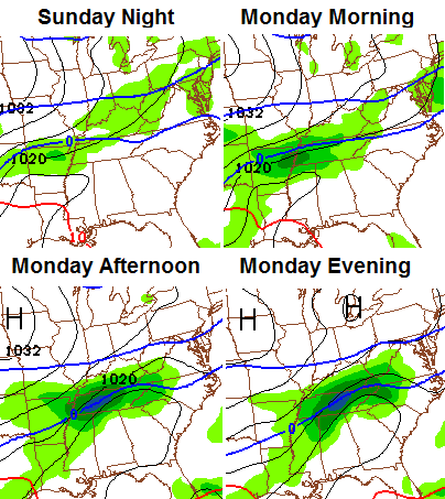
Additional rounds of light snow roll through over the weekend, but the one Monday is getting a little more of my attention. Recent runs of the Canadian and European models have shown a more robust system and the NAM is now trending in that direction…
 That will be followed up by another storm system by the middle of the week. That’s the one that tries to take on a much bigger look across the eastern half of the country.
What a winter!
I will update things later tonight and on WKYT-TV starting at 4pm. See ya on the tube.
Take care.

Chris, I know you are dying to start jogging, so I know you have looked down the road. Any comments on when you see winter breaking and us getting back to normal?
I know the next couple of weeks look bad, but when do you see this pattern breaking. End of the month, first of March, Spring?
Hey bud! Looks like it should begin to wane here in a few weeks. My worry is it comes back for one last encore in early March.
Thanks a bunch. I know you well enough to know you want to be running right about now. 🙂
As long as it doesn’t hang around into May like last year I will be ok.
Why wait for it to warm up? I always go hiking continually each winter and it’s great exercise. If you are worried about ice for running (though, there are plenty of days in the season with nothing on the ground), it’s not nearly as much of an issue with hiking.
Why wait? I went three miles just a few minutes ago. Not bad with low wind 🙂 I stupidly went one night a few weeks ago when there was wind and about ten degrees, not counting wind chill. Not too smart.
if you feel like you need to wait for it to warm up then go right ahead. Don’t worry about what anyone else might think. You got to do what is best for you. You’re no more of a hero just because you go out in the cold weather.
In most winters like this (cold), when spring arrives–it arrives, unlike last year. I’ve heard rumors that the pattern should change mid-month or a little thereafter. Guess, we’ll find out soon enough.
Looks like the trends are the southeast Ky friends, more snow will be in southern and east KY this weekend and early next week the way it’s looking now, you starved folks down that way may play catch some this weekend on snow totals 🙂
Catch-up!
I think temps will come into play Todd can’t say for sure until it arrives
Plus the northwest shift will come in play. Always does. Ha ha….
you catch on quick thats what brings the warmer air 😛
Cold air should not be the problem with these next storms, maybe moisture amounts and variable dry slots, theirs always something in Ky to battle when it comes to snowfall!
Were not exactly snow starved…Had a couple of 4- 5 inch snows…A couple of 3-4 snows and several 1-3…Probably around normal for this time of year..Looking at the Jackson totals we have about as much snow as anybody else in the state..Just waiting for the Big Dog to put us over 40+ for the year..
where are “we” at ?
Thats what I was gonna say Andy…we have only had maybe an inch & half!!
Flurries in London most all day so far. Hoping the trend holds which would catch us up on some good snow totals over the next couple of weeks. Monday looks interesting, for sure.
Not buying that we get snow tomorrow. Temps will hit in the 40s in London and just give a miserable cold rain. I’m so ready for this crap to be outta here. I’m looking at my golf clubs everyday and thinking it won’t be long – can’t come soon enough !!!!
Thanks Chris. Looking forward to your thoughts asthe systems get closer. Have a great rest of the day, everyone.
Just from watching the animals and nature I’ve been guessing that pattern gonna break around the 20th of feb. I do most my guessing off such things, wooly worms was dead on so far this winter
Did you all are where it was in the 50’s today in Sochi?
Sochi is a sub tropical climate. They have palm trees there.
Yeah. Sochi is located on the Black Sea. Average temps are in the low 50’s this time of year.
Somewhat like Vancouver where of course the 2010 winter games were held.
Both Sochi and Vancouver get relatively little snow and their snow covers tend to be shortlived. But both are adjacent to high mountains which normally get lots of snow.
Actually the palm trees are fake there.
Thanks for the update Chris, Mother Nature and Old Man Winter are sure keeping you busy. Maybe this system will give Andy some snow . I live in Estill and sure would like to see more myself. Everyone stay warm and safe.
NWS cancels the winter weather advisory for Louisville and frankfort, but leaves it for Lexington, Lawrenceburg areas, seems like splitting hairs at this point to take down one or two Counties??
Maybe their on to something, not a cloud in the sky in frankfort at the moment, much more sunshine than expected, not complaining though, looks great outside!
12z and 18z NAM is looking pretty good for southern and southeast KY for Monday/Tuesday.
I guess that should read “are” looking good. Don’t want to sound like an idiot haha.
How good inch wise?
Surprised Chris hasn’t mentioned the WWA cancellation on his twitter.
Neither have the MET’s in Louisville, except for Fox41.
It sure would look silly to take down 3 or 4 counties just to have them end up getting the same snowfall. They must seem fairly confident the snow will not reach I-64 and points north.
My thoughts to, as we have seen this year every storm large or small always trends north as the event happens, we shall see?
“It Won’t Stop Snowing”
🙂
It’s a headline I thought I’d never see on the blog
…. in certain parts of the state 😉
Yes! NAM models are showing us southern counties finally getting some snow!
http://grib2.com/gis-snow-overlays3.php3?BASEHR=12Z&STATIONID=JKL
http://grib2.com/gis-snow-overlays3.php3?BASEHR=12Z&STATIONID=PAH
Looks good….the Tennessee slider I have spoken of before. We will just have to wait and see….
Yes, Nashville just might finally get a moderate snow (we’re only at 1.4 so far this season, an average year gets closer to 10). True, the NAM is not as accurate this far out as other models (NAM’s sweet spot is more in the 24-36 hour timeframe IIRC). But I suppose even this warm wx person would not mind at least one nice snow, as long as it rapidly warms up soon after the storm.
However, Nashville’s all-time record single snow came in mid-March. 17 inches back in 1892. So anything can happen.
As mentioned, suppose even I would not mind at least one more snow. This is despite having just arrived back from Philadelphia. There was already snow on the ground and right after I arrived, an ice storm hits. The most winter I have experienced so far, apart from the near zero readings Nashville had back in January. Our meetings went on with few problems as were were largely self-contained in our hotel, and the worst icing happened just to the northwest of town. But I will be so glad when milder temps will be here to stay.
Hmm, perhaps I need to bribe my boss to send me on business trips in San Juan, Puerto Rico this time of year 🙂 . I’ll gladly brush up on my Spanish if it means some nice 70s and 80s.
As long as not the central area below the river, ANYTHING is possible 😉 …… (:
Hey Chris…..alittle while ago there was a strange ball up in the sky….it was big and bright……what do you think it might have been ??? 🙂
Sun Dog, saw it in frankfort!
I think it has something to do with Ice crystals in the clouds which form a 2nd sun effect!
🙂 🙂
Drove to the great white of Lexington and on the way and while i was here you can sure tell who had and who has not had snow by pot holes
Hey! You non snow getting folks need not dwell around the snow elite! 😉 🙂
I tried not to stay long
For some reason I have a feeling that winter is going to want to hang around again this year. The not so accurate Accuweather’s long range forecast didn’t show great numbers for the rest of the month through March. Many more below normal days than above. I would think the law of averages would eventually have to take over and bring some above normal days shortly. Don’t want a repeat of last year.
On a good note the climate prediction center had March – May slightly above normal. Bad thing is that I think they had the same thing last year.
I’m ready to buddy.
Hi Chris!
Took a contract in Fresno Ca and still enjoy getting your email blogs! We are FINALLY getting that much needed rain here this weekend. I have to smile as I know you all are shoveling your tails off while I open my windows for the day and air my apartment 🙂 You’d be interested to know my new job here is connecting new Solar,Wind,Hydro, and Bio-generator developer sites/farms to the New Smart Electric Grid. Too bad Kentucky can’t get with “the program” because these are coming up like weeds here in northern California.
Stay warm!
“The program”….. Total cost of operation is nuts high (I should know and do). One of the reasons California is so far in the red 😉
Did you know the average wind mill actually consumer more energy to build it, ship it and install it and maintain it, than it may ever generate for ROE (return on energy)? I say “average”, since it makes more sense placing them in areas that are logistically challenged to afford other energy options.
They DO have value, but not in their current, our tax dollars subsidizing them method. Without the subsidizing, a lot of those systems would either go bankrupt, or consumers would see MUCH higher bills to try to keep the P&L in the black with inflated revenue.
Sorry, you struck a nerve with “the program” comment. Though I am sure it is well intended, there is a saying for good intentions sometimes 😉 🙂
Consumer- consumes. My post meant no offense, to you, BTW 🙂 Just concern on the industry niches total cost management approach (there is not really one by default, due to the subsidizing).
Kentucky is already stressed enough without all that stuff- especially the windmills, but would be great for a deer stand 🙂 I am more likely to scare the deers off though and tick off the hunters 😉
….. I feel bad posting this now…. I stand by the content on the subject, but this was not the forum for it, nor directing to you, who seem nice. Sorry 🙁
Cabin fever Bubba??
Nah, but read the blog way too soon after jogging and working out. Adrenaline fail.
uninformed and inaccurate…that said I really do hope you get some snow.
Who is uninformed?
Since KY can’t get the solar, wind or hydro we’ll just stick to coal – the best energy in the world
Well, Swag is correct, since a windmill would not be a good deer stand. Way too high up! 🙂
Considering my profession and other “stuff” I have obtained though seven loooong years, I am anything but uniformed….. That said, Swag was nice enough to wish snow, so I will call it for what it is. Nice gesture.
You really need to find another way to submit comments on this blog. Your incessant spelling failures make you seem quite ignorant.
Fail!
Looks like a line of snow is starting to come into west Tennessee and extending up toward the Nashville area.
Dodger says new NAM is looking snowier on Sunday! Bailey on the mark yet again! Dodger
You never know 😉 As long as ice is not a player, good system 🙂 That is my reluctant, though positive spin view now. Just would be nice if Andy and his neighbors got a good snow. We at least got a 24 hour wonder.
I’m taking it that Jackson does not plan to issue WWA for it’s coverage area? Interesting…..
Not really
Waiting on Jackson to add the southern two tiers of counties, at least, to the Winter Weather Advisory…..
No need for official wording from any NWS sources, I feel it’s a pretty safe best most of you in Somerset and Pulaski county tonight should see some snow. Coffeelady, keep us up to date! 🙂
I’m pretty sure a NWS Jackson map was showing 1-2 earlier today for my area. The new one they have out is showing less than an inch. An inch would just about match our biggest snow of the year.
Sad to see that CB just said on the air that our snow starved counties in the south east may see up to an inch with this system. When one inch snows are being talked up for your area in February, you really know what kind of winter you have had as far as snow is concerned.
you would be correct bobt about the NWS and their earlier map and as far as us snow starved getting a maximum of a inch that has been the story of the winter and that has meant we get maybe a coating if that.