Good Friday to one and all. We have more snow heading toward the bluegrass state over the weekend and the action will come at us in waves. These waves of snow will likely put down light accumulations as they roll across the bluegrass state.
Today will be another cold one with temps in the 20s and a mix of sun and clouds. Those clouds will quickly increase as the day wears on and those clouds will start to produce snow later tonight. That’s the first round that carries us into Saturday morning…
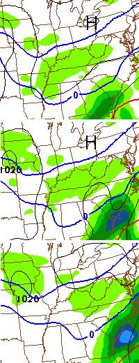
That can lay down a quick inch or so of snow and cause slick roads early Tomorrow morning. We should catch a break in the afternoon before another round moves in Saturday evening and night…

I warned you these were coming in waves. The next one shows up Sunday evening…
The Canadian Model shows another one Monday morning…
Accumulations will be likely over the weekend and many folks should pick up an inch or two with higher amounts possible. Please note it’s not all coming at once, but with each round that swings through here.
Moral of the story… it’s going to be a wintry weekend. Yes, I am watching the potential for the middle of next week, but we have to track what’s upon us and I’m too tired to wait all night on the full model runs. 🙂
I will give you a weekend update and talk more specific about the snowfall potential later today. Take care.

Get some sleep Chris you worked way to hard for us
Just saw the NWS climate update, it looks like lex had .5 of snow on the first update, and then another .5 on the other update, which means there was another 1.0 of snow yesterday…..Total from Fall to now is 16 inches even.
I will say that I’m OVER winter! I feel like this winter has lasted a YEAR so far.
And regarding the snow in the deep south and all of the accidents……..It’s not like we get THAT MUCH snow here…….And people can’t drive in snow……….But after the madness from the snow they had down there and all the the accidents, are we really that much better at driving in snow here than folks there (relatively speaking)? Maybe we get so many frequent small snows that cause slick travel that we tend to drive more carefully? Even still, there are always still numerous accidents, even way up north, like in Lafayette Indiana a few weeks ago.
Here’s an interesting write up about the “Atlanta snowpocalypse.” It even talks about a met that did something pretty brave. http://blogs.mprnews.org/updraft/2014/01/how-to-prevent-the-next-atlanta-snowpocalypse
Thanks for the awesome job you do and the way you go “above and beyond” for your readers! Get some rest — it’s more than well deserved!
I’m loving all this winter weather myself because it’s so unusual for us!
Yet staying so usual for the other half of the state. Boo!
Hopefully we’ve not saw are biggest snow yet!
Andy is hoping so, but a relative term. A bigger snow for them would be 1.5″ 😉 Funny how where I live is mainly ice and a coating of snow, but ten miles up the road there are 3″ more snow still sitting there ins spite of the rain and ice.
Location, location, location!
more like 20 miles or more. I am on the other side of the river and have what feels like a couple inches of ice and a dusting of snow. makes it real fun to take the dogs out!
Given that it seems to be the nexus of determining accuracy for a forecast, I’m fairly certain the only solution to this is to actually live in the WKYT station parking lot. 😉
I do not mind the snow at all if it would just warm up a little. It has not been this cold around here in years.
Thanks for keeping us informed. I am loving this winter. I hope you get some rest because you sure need it the way you work to let us know what to expect.You are the BEST.
If we ever get enough snow down here in the Southern counties to make a good snowball, then I will be satisfied. 🙂 Let it snow!!
I dream of daffodils and hearing the little spring peeper frogs. I know spring will come….at least hope it will. And soon, please! Winter has outlasted its welcome as far as I am concerned. I have to admit, though, there is beauty in all seasons. And, I suppose, the winter we’ve had will make us appreciate the coming spring. Take care, all.
I appreciate our light accumulation and snow day yesterday in Laurel County, but I speak for many of us “southern” folk that are looking for one big snow to march through here before we plant our gardens. Have a great day!
Hopefully next weeks system brings us an old school. Weekend look alike just more annoying ankle biters. I say either go big or go home. Mid February is almost here and average temps get to the point where we should get some decent days to get outside and enjoy it. Not worth staying cold for one to two inch snows.. If that’s all that we can get I say bring on spring.
Toe biters combined they may =1 ankle biter if they stick around long enough for 1 to lay on another
Looks like a SNOWGLOBE weekend. Thanks CB for the updates! Still have a full month of winter left. I really doubt this is our last few chances for cold and snow. As CB said a few post back “We have NOT seen our biggest snow yet”.
I think CB thought one of these last two systems coming through was going to be one of those “big snows”. The moisture was in place, but the cold that had been in place all winter didn’t stick around. We may get an big snow, but I highly suspect he thought one of those two was going to hit. The farther we get into February, the more unlikely it becomes.. It has happened before, but hard to get temps and mositure to cooperate.
Louisville “officially” needs 10.3 more inches of snow to crack into the top 10 snowiest winters. The airport sits at 19.9 inches.
We are at 24.8″ in NE Lou.
Winter Weather Advisory from Lou to Lex to BG overnight.
More light snow?!?! When is it going to stop? Its be snowing lightly here in Lexington for 5 days straight! Not nonstop, but at least some measurable snow. Already at 5.4″ for the month of Feb. so far.
25 here in Knott county this morning
Get some rest chris. Hopefully the weather will settle down soon and u can take a break. 🙂
Also, what a temperature range! In Lexington, were sitting at 11° but in Frankfort, it’s 4°, a 7° difference! It’s all single digits north and west of Lex, but teens and 20s east and south.
Thank you CB for all the hard work you put in. It is VERY VERY HARD for me to imagine anyone being tired of this winter already. I’ve seen maybe a total of 5 – 6″ here in Southern Laurel County. I have to admit though, I am sick of the brutal cold and no snow. If areas down here is to have no snow again, past 3 years NOTHING, then come on Spring. I remember a couple weeks ago everyone crying and complaining about how northern Ky has been doing good but no where else. Well, now that you all have gotten a good dose of winter, you all seem to be having fun griping about the southern counties folks still grumbling about living in the DOME still. I like how Andy said “TOE-BITERS” We can’t even get enough snow to go above the souls of our shoes and you guys are sick of WINTER?
GIVE US SOUTHERN FOLKS A LITTLE BREAK. On the good note, I think we down here in Laurel, Whitley, and Knox should be able to plant PALM TREES and spread some sand around, at this rate! Have a good day and enjoy your wintery weekend. I am sure I might see a flake come down.
By the way……we are sitting at 24° and no snow on the ground!
Keavy Man, my husband has joked about that very thing. He says that he’s going to order some and have some sand brought in and plant it in the front yard! Nice to know that someone else feels the same way we do. Yes, southern Kentucky needs some snow love, for sure!
Was 5 degrees driving to work this morning in Taylorsville.
Getting a little concerned about next Wednesday/Thursday. I’ll be driving from Cincy to Atlanta early Friday (2/14) morning. I know it’s early for any forecast, but what are you guys seeing out there for that time frame? Our locals have us in Snow for that time frame.
Thanks everyone!
Enough Already.
I’m starting to feel the same way a lot of you do. Bring on Spring. Obviously, we here in Middlesboro haven’t had the continuing snow that you in the northern half of the state have had, but 6-7 days a week(every week now for over 2 months) of gloomy gray skies is enough to make the sanest man go crazy! We need some sunshine, even if it is cold! I’m officially over this winter!
WKY just placed under a WWA.
Thanks Chris. We have very fine grainy snow falling here this morning with a temp of 22 degrees. It has snowed enough that the roads are white and cars are covered. If these flakes were big flakes, we would have probably an inch or so this morning. I saw where there is a winter weather advisory out for parts of the state overnight. Once again It butts right up against us but we are not in it. So we will probably get more out of it than anything… 😉 Have a great Friday everyone. Stay safe and warm. Thanks again Chris.
Thanks, Chris — I appreciate all that you do and hope you’re able to get some rest today. Don’t let the critics get you down!
Chris you do a great job, I agree with everyone you need get some rest. Thank you for all that you do for us in keeping us informed of the weather. We could not do with out our weather man Chris Bailey.
Temp got down to 4 in east frankfort, a couple more inches of snow on top of our 4 inch snow and ice pack is coming sounds like, winter like I have not seen since 1996 here,
might of had more snow in 2010/11 but no where near the persistent cold and snow on the ground duration of 2014! EPIC
I thought anything over an inch was EPIC! 🙂
We are sitting at around 37-38″ of snowfall in Northern KY at CVG for the season so far. We haven’t had bare ground very often at all since the start of the year, a couple days around mid January, and again last weekend into early this week before the snow / ice storm hit.
Maybe snow lovers will get The Big Snow next Friday, which is Valentines Day. Wouldn’t that be “loverly”? Hope those of you who haven’t had much snow get a nice one then, or soon.
Some light snow in snow-starved Nashville TN, currently 17 degrees. So ready for spring, even though it brings the annual increased threat of severe t-storms/tornadoes.
But, alas, Winter Weather Advisories are out for much of Tennessee and Kentucky. Jeez, even southern Texas, including the southernmost tip, is under a WWA. Will it ever end?? 😉
17 in TN and 27 in Knox County KY lol just needs to warm up 5 or 6 degrees 😉
I endured the ice storm that brought parts of the northeast to its knees. My flight arrived Tuesday evening in Philadelphia; the freezing rain started after midnight. Downtown got roughly .3 inch of ice, but counties just to the northwest of Philly were much harder hit.
Hope everybody in KY has their power back by now. Saw a report of .75 inch ice in western KY near the TN line (LBL area) 🙁 .
.75 in Union Co also on Ky/IL line. 09 ice storm had grid MUCH better prepared and in good shape for this last storm.
It was snowing tiny pretty snowflakes at a pretty good rate this morning here in Berea. It put a light dusting on the cars but didn’t cause any problems. I checked the radar and it did not show up at all, which surprised me! Stay safe this weekend.
Will be drivin’ up 65 towards Louisville from Nashville on route to Indianapolis tonight. It’s going to be really nice to see some snow on the ground.
Nashville still lookin’ for their first 1+” snowfall since 2/9/2011. :/