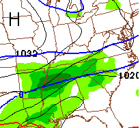
Good Sunday, everyone. If it’s a new day in Kentucky that means it’s another day with light snow rolling across the region. This marks the 8th straight day we’ve had snow in the air. An even higher number of consecutive days has featured snow on the ground for many. It’s been that kind of winter around here.
It’s not done quite yet. Bands of light snow will work across the bluegrass state today into tonight. These bands can lay down light accumulations for many. I wouldn’t be surprised to see a few spots pick up on another inch or snow by Monday morning.
Your trackers have you covered…

I-75 @ Winchester Road Lexington

I-75 @ Iron Works Pike Lexington

I-75 @ Clays Ferry Bridge South Between Lexington and Richmond

US 60 @ US 127 Frankfort

US 127 @ Frankfort Frankfort

I-75 at MP 36 London

I-71/I-75 at Buttermilk Pike Near Covington

I-64 @ 3rd St. Exit Louisville

Downtown Louisville @ 2nd & Broadway Louisville

I-65 @ 234 Near Bowling Green

What happens after today? That’s the million dollar question and the one I’ve been trying to get a better handle on. As mentioned, the southern branch of the jet stream is loaded with systems rolling across the country. Timing these is a pain and each will impact the one behind it.
The next system for Monday looks to go to our south, but may brush southern and southeastern parts of the state with some light snow. The NAM…
This is nice shot of arctic air coming in behind that and could send our temps toward zero or below by Tuesday morning…
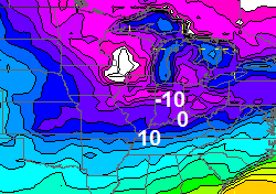
Highs Tuesday look to be in the upper teens and low 20s with another single digit temp night to follow.
It’s once we get to this part that of the week that I have yet to fully figure out. To be honest, I haven’t put a lot of time into it and have spent some of the weekend recharging my batteries after this wild stretch of weather. I do think we have another wild stretch or two to go before we’re out of the winter woods.
I will have another update later today. Take care.

Sounds like winter is about ready to choke, but that’s fine I have had enough in frankfort!
Yea I’ve done gave up on a big snow so might will get spring going just hope tornadoes stay away can’t look forward to the seasons I’m so fearfull of tornadoes…
100% this.
For those that may be reading the blog in other parts of the world bedides kentucky, those 8 days in a toll to feature snow is for northern parts of kentucky. Southern kentucky had rain all last weekend, rain in rhe tues/weds storm last weekend. But chris said it best, its been that kind of winter here. One system after another, precip type varies to what part of state you live in. Southern ky has had a few rounds of dnow, nothing yo write home about except the 3 to 4 incher that feel last sat morning, but temps warmed up in 40s hours after the snpwfall, and temps was in 50s next day on Sunday.
Most people I have talked to is ready for winter to be over. I think its where the overall pattern has been a cold wunter.
Actually that’s central and northern kenrucky to have got snow everyday.
Thanks chris for update, enjoy the not as active part of what the pattern has been. This winter has been brutal with how to forcast for sll 27 viewing area. I trust your forcasts, and enjoy reading your thoughts on what Could possible be troubled or excellent weather coming our way.
Hopefully the kids can get back to school this week. Alot of days to make up here in Mason County 🙁
It is snowing heavily here in Bowling Green! Winter Weather Advisory needs to be issued here! Everything has been covered very quickly with low visibility and it looks to continue for at least the next couple hours with lighter snow showers developing on radar back near Paducah.
Thank you for keeping us updated! 🙂
Thank You for all your hard work.
thank you Chris.
we’re enjoying the daily snowfall- hope we can wrap up winter with one last biggun’.
Good Sunday to all
Wait?!? Are you telling me that Robert Thomas allows you to rest? He must be running a loose ship over there.
We Kentuckians are not unreasonable. I would be fine with you working only 22 hours a day and providing a cot on the set.
You deserve the rest. ~
Sitting in mid 30s in knott co this morning, I’m calling for 40 a here today
Gearing up for a heavy wet snowstorm here in southern tn…come on down..lol
Thanks for the update Chris. We had some beautiful snow yesterday morning. I look at all the camera shots you show and see where you can see the snow. Amazing that they all show white except for London. Our snow was gone before noon yesterday. Don’t understand how ours all melts so fast. Unless it is due to all the rain we’ve had. As you said yeah it’s been that kind of a winter. I am hoping we can get one decent snow in the southern part of the state before we get to spring. But, if not we will deal and go on.
Chris you deserve a rest. Glad you had a chance for a little bit anyway. Everyone have a great Sunday!
Same thing in Bowling Green.
You KNOW it’s been a long winter when Mr Bailey is tired. Thanks for all you do and get some rest! I’m headed to Florida tomorrow so all is good!
Its been a colder than the last 15-20 yrs thats all i can say
I’ve missed more snows than I want too but at least we’ve been “in the game” this year. Chris is right when he says eight straight days of snow in KY is impressive.
For my area this year, it may have been the fewest times in a long time the we were “in the game”. CB is the snow man and I think the biggest prediction he made all year for Knox Co. was maybe a 2-4 inch snow. Most of those times we only got a dusting. Even if the high end had hit, 4 inches is not a real big snow. Even with all the cold in Kentucky, only one system was borderline on busting the dome and giving central Kentucky a pounding, but the transition from rain to snow took to long. The dome is very much intact.
I’m not in your dome. I’m in northwestern KY and have about 12″ total for the season altogether. Biggest single event snow was 6″ in early December. Rest has been dustings and an occasional inch. We’ve missed three big snows 50+ miles to our north. Lots more chances than past few winters.
Yeah, you guys were close to a few big snows. Not even a five day out map looked promising for SE Kentucky this winter. Not fun having all the cold with very low snow totals for the season. Just made for a lot of dreary days. I need some sunshine and warmth.
Then I guess it’s a good thing that we haven’t had very much snow or it would be a lot worse.
Snowing heavily here in Lexington, already covered everything including the street, maybe this can overachieve? I’m a happy camper! ( ͡° ͜ʖ ͡°)
Got a quick 1/2 in of snow in Cynthiana this morning. Starting to slow down a little now.
If this TN system gives them a few inches tomorrow them that will mean that all areas 100 miles north of me and 100 miles south of me have all saw more snow than me this year. Southern Kentucky (Knox co. ) has just not been the place for snow this year. It has been cold though if you are the type that enjoys prolonged spells of cold and no snow, then this would be your place.
Just started with some snow flurries here in Berea after RAINING overnight and early this morning. Color me surprised, as this wasn’t in the forecast.
Some people having snow in the air or a little sniff of it on the ground a few days in a row is pretty far from “extreme”, “wild”, “crazy” or any other overly extreme description. It’s the first third of February! I guess our long term snow drought has skewed perceptions that badly over time.
having close to 6 inches on the ground for a week is not a sniff, frankfort is a much different world than you describe, take a drive north if you don’t believe it!
Roads slick in Frankfort, maybe another half inch or so, interested to see what the upcoming week has for us, some folks saying mid 40s by late week?
Cold rain!
That large area of precip over Nebraska appears to be on a “direct hit” mission for KY!
Good because i need the salt washed off my vehicles
Now that’s funny! 🙂
but true
8 days of snow in a row? And yet nothing on the ground….lol….new invention….Invis-i-Snow………you guys in Knox County have had piles of it….just couldn’t see it….
Is anyone else as tired of these dreary gray skies as I am?
As long as there is snow, then no.
Then my answer is yes
I think temp goes to around 10 Monday night then temps going to start rising over the week. If storm systems moving in ky river south will get in 40s and rain. Just my thoughts.
Btw these little flurries not much here in richmond not much at all this weekend … I wish we had the snow on the ground like lex , gtown and Frankfort
Hey Andy Rose ( and anyone else who has time to comment) is London going to get any snow today?? Thanks to all you bloggers for your opinions and special thanks to Chris B. He is indeed the man!
Doubtful unless its late tonite
As Andy said, any snow for London looks to be late, maybe 9pm or later, and less than half an inch, main band looks to stay north of you.
Been raining/drizzle in knott co off and on temp right around 40
Is it just me or is that precip to our northwest getting ready slam us?
I was just popping on here to post the same thing. Looks like we may get slammed.
Dodger wants more snow! Is that too much to ask for in Dodger Land!?
Just for record..Mercer County/Harrodsburg is like CB describes. We have been snow and ice covered for many days. Snow also fell and accumulated yesterday, last night and this morning.
Also noticing the precip shield to our west near St. Louis and Illinois. What are some of your all’s thoughts about this evening’s light snow event turning covering a wider area than Wave 3 is predicting? Ryan Hoke out of Wave 3 acted like that was a narrow band (mostly south of Lou and Lex metros) on his Sunday morning blog.
Just based on radar trends, looks like the precip is lining up to be along I-64, rather than south of it. Looks like a 1-2″ event in these areas if the bands hold together well.
Interesting! Hope you’re right!
My thoughts on the winter…
Not that different from the other 8 years I have lived in Madison County, it has been colder though. My part of MC has seen perhaps 10 inches of snow, 8 of them in two “storms” that came in quick succession. That’s right, two storms = 8 inches. Besides that, we have about 2 inches in a number of toe ticklers. Amazing how different it can be only 20 miles away. I have seem myself the difference in other areas like Lexington, Frankfort… If I move a little further south it seems they have had even less than MC. Perhaps will all change with the next “week away storm”
So, I started the winter with IBIWISI and then moved on to my three pronged fork of the winter:
1. Fear the trend
2. Don’t trust the models
3. Respect Chris for his expertise and efforts
With about a month to go of “real” winter I am still hoping…
Ok, Chris basically just answered my question above with his latest tweet. Wonder who has the best chance to be “some areas” that he is referring to doing better than an inch?
If the trend holds Lexington and north. If it misses them then TN has the best chance. :).
Lol!
Posts not going thru
In southeast Ky. I don’t think we have seen a ray of sunshine in about a week now. Typical February weather though. Cold, dark, damp, dreary.
I know. Looking forward to some bright sunshine! At this point, I would trade even a big chance of snow for some sun.
This snow coming in tonight does look pointed at places south of I-64, look out Bubba it’s comin for ya 🙂
Where would south of I-64 be.
Geographically? look at a roadmap!
r if you meant where is it going to snow south of I 64, you’re just going to have to look at the radar.
where are you c biv I like to hear your perspective from a northern Jefferson County point of view.
sorry, you cannot trust the radar.
Gentle to our other bloggers. You may not know who is of a younger age and curious!
I apologize to Vanessa.
.
Yes, southern Jeff co. Would be considered south of I-64.
Where I live would be like 7 miles north of that line.
I need one more snow day. The others I’ve wanted, but tomorrow I need one so I don’t have to take a sick day! Lol
Setting at 43 here in knott co
35.8 in my part of Knott Brad
LOTS of virga on that radar. Some will get some decent snow but that radar is misleading, unfortunately, as it’s taking some time to saturate all levels.
do you know any Kentucky weather stations reporting snow
If you look closely on the us radar…you can see the snow following the jet stream…or so it looks like to me lol
Big dog barking at the door for Southeastern Ky maybe mid week..O So close..
well maybe it will bite but not holding my breath looking at the models earlier today
Euro is your friend..GFS has no clue…Just need the ever popular NW shift…The Euro and Nam is developing a second wave that is putting down some good amount’s south of us but has started to trend a little more north..Tonight’s run of the Euro will be very interesting..
The south is going to a decent snow again this week, look at all the winter storm watches, some spots 3-5 inch snows which is huge for those folks!
20-25 years ago, 5″ of snow would be considered small for the Tennessee valley. As a kid, we frequently had 8-10″ snowfalls. Those were good years with fond memories. Even though I live a little farther north now, I haven’t seen a snow over 8″ since 1993 and starting to feel as though i never will again without traveling away from this area.
Most of the watches are south of Tennessee at the moment, most of these areas average less than 2 inches per year!
This may be a dumb question, but why does it look like it’s snowing on the radar, but it’s not? My county is blue on the radar, but it isn’t snowing outside. 🙁
The only dumb question is the one not asked 😉 .
It may be virga (precip that fall from the clouds, but due to the dry air below the rain/snow dissipates before it can reach the ground).