Good Sunday evening. I promised you wave after wave of light snow this weekend and Old Man Winter is bringing the goods. Another round of light snow is rolling eastward this evening and may cause some travel issues before all is said and done. No, this is not a recording!
I’m actually more impressed with this round than any of the others this weekend. I think some areas along and south of the Interstate 64 corridor can pick up another inch or snow from this. This will likely cause slick roads this evening into tonight.
A lighter brand of snow moves in on Monday with readings coming down into the low and mid 20s during the afternoon. If skies can clear Monday night… look out. Temps can drop to zero or below for areas with snow on the ground.
I keep watching the Wednesday-Thursday storm system that is just beginning to come into decent range on the models. This storm develops across the deep south and then rides up the east coast. Will it be just off the coast or inland as it does so? That’s what we will have to figure out over the next few days. The European Model continues to show this coming far enough west to bring some snow our way…
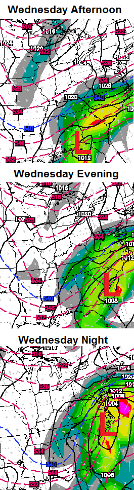
The run before that one was even more robust on our snow chances…
The Canadian Model is trying to get to a similar solution…
If you want this storm to impact our weather in Kentucky, you want to see the energy hang back and bundle. If it becomes too strung out, it barely misses us to the east. It won’t be until Tuesday that the models figure all this out.
First things first and that’s tracking the stuff moving through this evening. And away we go…

I-75 @ Winchester Road Lexington

I-75 @ Iron Works Pike Lexington

I-75 @ Clays Ferry Bridge South Between Lexington and Richmond

US 60 @ US 127 Frankfort

US 127 @ Frankfort Frankfort

I-75 at MP 36 London

I-71/I-75 at Buttermilk Pike Near Covington

I-64 @ 3rd St. Exit Louisville

Downtown Louisville @ 2nd & Broadway Louisville

I-65 @ 234 Near Bowling Green

Take care.

“It was 50 years ago today….”
Guys, the old school cold and snow days are going to come back, you just have to be patient, for about a decade or so. Here’s why (read ’till the end) http://www.wlky.com/weather/the-season-snow-total-is-at-20-how-does-that-compare-with-past-winters/-/9367530/24370094/-/u4vnvg/-/index.html
I think this winter, is just the beginning for the next decade or so of winters to come and will become the norm again.
I truly hope not, considering that we here in the southern counties averaged much more snow without the intense cold in the previous years….
thanks Israel. very interesting reading…..maybe we’re headed that way!
Thanks Chris. Hopefully the mid week will bring on a good one. Although radar looks kind if impressive right now. Not hitting the ground here yet. Stay safe fellow weather friends! Thanks again Chris.
I would love for you to have an app. Would make it so much quicker to read your posts.
Dodger likes this weather! At home, warm & cozy in front of fireplace. Would be better if fire was lit. Dodger!
That traffic cam in London needs some snow on it. It really looks out of place considering it and the one in Bowling Green is the only ones that is not showing snow. Pretty much sums up the winter around here. If this mid-week storm hits, some areas without much snow this year will be the ones that should get it. I wouldn’t mind one more snow considering that temps are going to be low this week. If it’s going to be cold, might as well throw in a little snow. After this week though, I am more than ready for spring. It’s warm up time.
I really wish there was a cam with a better location in Laurel county.Can not see anything on it at night.Would be much better near one of the exits where there is some lighting or just off an exit near traffic lights.
Its been snowing very lightly for about an hour now.Can see a very think dusting.Temps have hung around the 30 degree mark most the day.
*think* should be thin dusting
Shouldn’t have to moisten the atmosphere up here in Knott county because it has been drizzling the rain all day long off and on. Hoping for a couple inches at least.
Not expecting more than a sugar coating in Frankfort tonight, hoping you snow hungry folks get a good covering tonight south of here, if that next system Chris is watching shifts a little westward lookout southeast KY could get smacked!
starting to flurry in southern laurel county
correction light snow
Any chance of this next storm moving North and West. Ha Ha…
Thanks for the update. Looking forward to spring and thunderstorms.
Looks like it should be snowing big time here in Lexington according to the radar. Verga??? Oh my
Please don’t snow, grandson has been here all last week, while I adore him…. please please do not snow lol!
This comment has cracked me up!!!
Verga storm in frankfort, don’t know if any of this will reach the ground, dry layer pretty strong in this area!
Hearing some forecast of 50 degree weather coming this weekend with rain, maybe this brutal winter is sowing some signs of easing??
The radar looked great an hour ago, but the system is breaking apart in the snow deprived counties. I’ve watched this system for a while now on radar and the thing pretty much held together until it got to this area. Just not meant to be. Can’t even get a good one inch snow around here. lol
Everything getting white here in Topmost of Knott County.
Snow cover on cars here in knox.
Don’t know how much is behind. Looks to be breaking up in the southern part of it.
Uncle
Snow is falling in Frankfort, might get that 1/2 inch yet!
Light dusting here in eastern letcher county
Radar shows snow over Irvine, but none is showing up on the ground. Could be an accumulation of verga?
Snowing in Clay County. Roads are becoming white. It has been snowing since about 7:15 here.
CB is right, tonight’s round of Virga is more impressive than yesterday’s or Friday’s.
You are quickly becoming an instigator and someone just trying to stir the pot. Let’s keep it up and see how it goes.
Snowing at a good clip in frankfort, NWS probably should have had an advisory in places, but to hard to pin down placement I guess, Frankfort looks to over achieve some from the looks of latest radar!
This has shifted a little further north from earlier thoughts by most METS!
Just walked the pooches and nothing falling in Richmond ATM.
It trended North because the low bounced off of Darth Bubba’s helmet!
🙂
At ludicrous speed! Spaceballs speak.
Since I posted last, we had a “burst” of light snow putting down a coating snow.
Snow heavily in Lexington. This looks to be an overachiever here and I see lots more heavy snow to the west!
Agree!
moderate snow here in Leslie Co..everything turning white
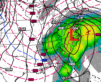
Very interesting run of the Nam…Andy the Big Dog is getting Closer and he is in attack mode..
Be patient and it will show its true self
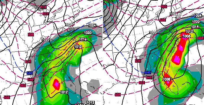
The new 00z NAM has made a significant shift west for the mid week storm..it is beginning to match up with the Canadian and euro models that CB has posted above..heads up central and eastern Ky..things could get very interesting this week
Yummy 🙂
Also slowed down as CB said it needed to do..Also looks like it gonna close off for a Big Dog Bomb..Here’s the clown map..
http://tapatalk.com/tapatalk_image.php?img=aHR0cDovL2ltZy50YXBhdGFsay5jb20vZC8xNC8wMi8xMC9vcmlnaW5hbC90YWphYmV0eS5qcGc%3D
We are covered up in the Masterson Station area of Lexington! What an awesome crowd pleaser!!!! Watching slope style too!!!!
Just got our WWA for the Lexington area… A tad bit late… But you know what they say?
Come to Poppa….Rolo where you at …”Old School” knocking on your door…
http://mag.ncep.noaa.gov/data/nam/00/nam_namer_078_500_vort_ht.gif
As CB just tweeted, a Winter Weather Advisory is finally out for KY, including Louisville and Lexington.
A tidbit: It was 20 years ago today that the devastating 1994 ice storm hit parts of south-central KY, much of Tennessee (especially Nashville and Memphis), Arkansas, northern Mississippi. My future wife was in elementary school at the time. Her family showed me old pics of the damage, including a telephone pole split in half! Makes me wanting spring even more, but if there must be winter let it be snow not ice!
When people say south central KY, I never know exactly what that means whether to include lex or not. I don’t think south central KY is lexington though……..I remember someone talking about the 1994 ice storm, but I thought they were saying here in Lexington. I didn’t realize that missed this area. Perhaps they lived further south.
Richmond got SMACKED with that one. We had no power for four days.
http://wxcaster.com/gis-snow-overlays.php3?STATIONID=JKL
00z NAM has come to play a little ball.
Wow! 00z NAM showing “the big one” for Wed-Thurs in South and SE KY and East Tennessee! Too far out for confidence but crossing fingers…
I hope it doesn’t move northwest………I’m sick of winter at this point.
lol I am as well, but since winter doesn’t seem to wan’t to let go, I’m really hoping this one pans out for us here in the south.
We’ll take the Big Dog..Big Dog coming to an area near you..Woof Woof..
About 1 inch already and still coming down in Mt sterling
00Z GFS is up and running…going to be an interesting run…
Looks like the majority of the snow is going to hang just a wee bit to the north of Laurel county.Pretty impressive on the radar if its hitting the ground.Just a few flurries here now.I am just fine with what we have so far.
Close to an inch of new snow in east frankfort, didn’t see this one coming, fun to overachieve when it comes to snow, bring on the next Chris, the midweek storm is trying to include central KY!
Roads are covered in Jtown, I’m guessing a new 1/2 inch on the roads.
Wow..The most sparkling snow i believe i have ever seen tonight..Look’s like diamond’s glittering..
Snowing moderately in Lawrence Co., just south of Louisa. Cars, ground, sidewalk and roads snow covered. Hovering b/n 29 and 30 degrees.
how are the roads in Laurel County?
Copied from the Sheriffs Facebook page advisory…..
Deputy Larry Parrott, who is on patrol, is reporting that all roadways in Laurel County are becoming slick right now–2-9-2014 at 8:56 P.M. Everyone please be careful! Salt trucks are out.
thanks for the info
You’re welcome.It has stopped snowing for now so they may improve but I think there is a chance we may get a small amount come through later tonight and early tomorrow morning.
Now the waiting game for the Webblings… school or no school!?! At this pace, we will be packing lunches in July!
So far Jackson and Clay has closed but Laurel may wait till morning to decide.
I would say a different run of the GFS than earlier..Even though a miss it is slowly correcting it’s self..
I agree. The Euro, Canadian, and NAM are all fairly close it looks to me. The GFS is starting to trend back to the west some, but still not as much as the other three. The NAM is by far the farthest west on this run. It will be interesting to see if it can hold course and the others can follow it. The 00z NAM track is about as perfect a track as you can get for an Eastern Kentucky snowstorm.
just opened my front door. That is the most BONE CHILLING 26 degrees outside…….BRRRRR
I would say another 1.5-2″ of new snow tonight in SW Lexington and still snowing. Have close to a 6″ snowpack now. This afternoon was the first time I saw clear spots on our neibghborhood streets in over a week. Lasted for a few hours. Completely covered once again.
I just drove from Harrodsburg Rd. to Winchester and didn’t see one salt truck on 64 much less anywhere else. Roads are extremely slick, I was in a 4 wheel drive driving slow (40 &45) and here comes cars driving the driving the speed limit!! SLOW DOWN PEOPLE before you hurt yourself or someone else!
I’m not the violent kind, but if winter had a face I would so punch it in the face 🙂 Its pouring snow here .. grrrr
Love it! More snow for Barb!
BOO 🙁 Its pouring so hard, I’ll end up with 3 inches before its said and done.
Chris saw this one overachieving, and he is spot on, CB is the best!
Overachieving? He said maybe an inch….MECK is now posting 4-8+ for my area…..what’s up with the two extremes?
That wlex 18 map is old, 4-8+ map is dated last week 🙂
You would be correct, barb.☺️
Easy killer
Light snow here in Carter County. When will things start warming up? I’m already beyond sick of the snow, wish the snow lovers that have been missing out could take what we have, haha!
Just measured here in east frankfort, 1.5 inches new snow, 6 inches on the ground!
Earlier forecast from NWS was less than 1/2 inch for frankfort, so yes this is an Overacheiving event!
By the way it is still snowing decent 🙂
Unfortunate to hear about so many road problems in Lexington, be safe everyone. Kudos to roadcrews in Louisville, at least out in J’town. While they were slick on the way home from work ~10:30, they’ve already managed to plow the side streets around me.
Got just over 2 inches here where I live in Morgan co
We probably have over an inch in Burgin. Roads are covered.
Just measured in 3 different places= 2.4, 2.6, 2.5. add, divide. I have about 2.5 inches in Southern Lawrence County- and still snowing.
OPS