Good Monday, folks. We’re coming off another snowy weekend in the bluegrass state. Last night’s system turned into an overachiever for many areas. I tweeted earlier in the day I was impressed with the potential, but it took it to the max.
You will be hard pressed to find more winter events sandwiched into a one week period like the one we just had. This winter is honestly going to be remembered as a great one by the general public because of how persistent it has been. Guess what? It’s not over.
Some areas will pick up light snow today… especially in the south and southeast. Bitterly cold air filters in from the north with readings in the low to mid 20s for highs. Gusty winds will make it feel much colder than that. Temps tonight will likely settle into the single digits. Areas that completely clear the sky can see readings drop to 0 or a little below.
Tuesday looks dry and cold with upper teens and low 20s.
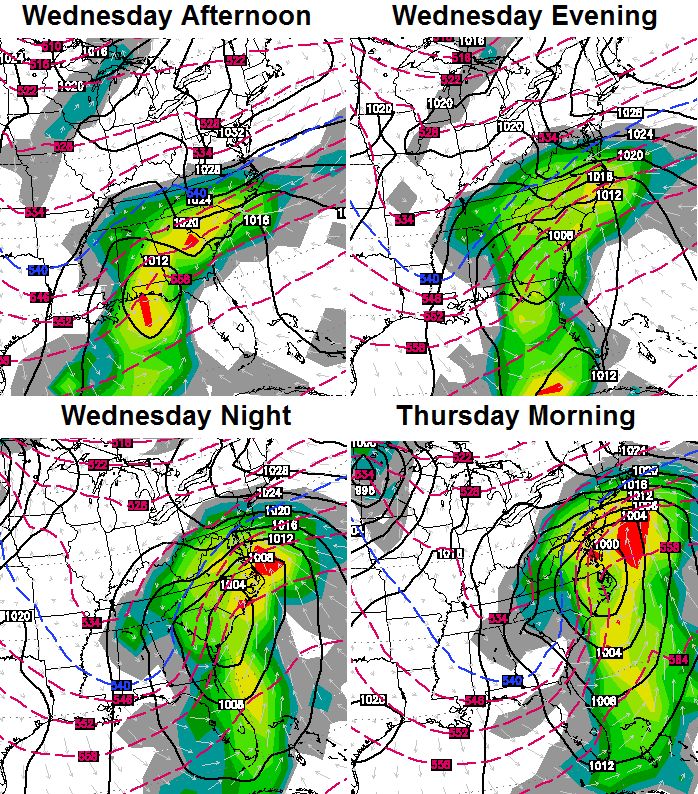
This takes us to Wednesday and what is likely to be a big storm developing to our south. This will roll up the east coast and may very well impact our weather. It all depends on where this low tracks. Will it be just offshore or will it be more of a inland track. The farther west this thing gets, the better the chance of us seeing snow from it.
The NAM took a big step to the west last night…
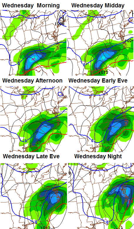
The European Model has been leading the charge on this western solution and that continues to be the case…
The Canadian Model has a similar look…
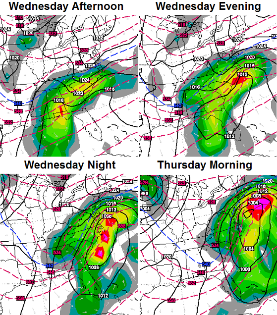
Again… we won’t have a full handle on how this storm tracks until we get into Tuesday. That’s when the models will be able to see all the players involved and have a better handle on how they interact. This could be a good snowmaker for our region or it could barely miss us to the east.
I will update things later today. Make it a good one and take care.

Just barely a dusting, if that, on my car here in Southern Laurel County. This is becoming the story as usual here. Seems we down this way has managed to miss every event again this year. If Wednesday’s event hits us, we will flood. Can’t handle much more rain. So…………..COME ON SPRING!
amen to that !!!! I keep hearing that the weather is going to make a drastic change around the 19/20th of Feb, with warm temps, but Chris hasn’t mentioned it at all – curious if he doesn’t believe it will change yet.
Got about 3 inches out of that one looks awful pretty out there with my christmas lights still up what can I say been to cold to get them down so might as well in joy them with this pretty snow…lol
Marsha – LOL
Your Christmas lights are still up?
Ha!
Unplug all but the red and white ones and call them valentine lights.
Maybe spring is waiting for you to take them down! I agree, snow and Christmas lights make a good combination.
Wagon’s West today please..
Had about 2 inches of the white stuff here this morning. Still waiting for that storm that dumps at least a foot cause I just love the white stuff!!!
Almost 2 inches of new snow here in Georgetown. The snow looks pretty- roads do not look so pretty.
thanks Chris….
another nice little snow here in Lex
just keeps adding on…no school for Fayette
looks like we’re on the fringe for Wed best case-hope the southeast gets a good SNOW
Northwest jaunt happens every time. When are you people going to learn. I jokingly said last night something about the northwest shift. Now we need it to come another 100 or so miles to the west up this side if the Apps. Would love to get snow in the Ville AGAIN.
That would be nice put the SE back in the rain again if that happened
Another day off school. Can’t remember the last Monday that we actually had school! Thanks Chris for keeping us informed! Everyone stay safe on the roads.
As per usual i see OPS
Lexington needs about 3 inches to makes this one of the 10 snowiest February’s on record. As of midnight, up to 17.5 for the season and 6.9 inches in February. When the party all started last Monday, I didn’t think there would be snow on top of snow for this long. That snowpack is so dense and ice-laden it will take some time to melt.
Yikes, don’t say that! The last two times I heard CB say that on air or on here, our snow was *literally* gone in 24-36 hours after such a statement. It looks beautiful outside and I’d like to keep it for as long as I can.
Andy, I think ill go borrow a umbrella from rolo, if any precip falls, we will get rain. Or harlan and black mountain will get a light snow, maybe a stray flurry in the laurel/clay/corbin areas.
The cold air seems to be in place for this event tho, we just need the storm to take a path to give our snow starved area some snow love.
Looks as though same areas got over achieving snow last night. Another dusting in Knox.
I thought we had frost thanks for clarifying
Sorry, I really wish at least one of these forecasts would result in a nice snow on the ground for you.
Here’s hoping most of us miss out on the mid-week storm and it’s all you baby!
That would be the shade side of a cold roof dusting. Lol. Not enough to get the ground white.
I had about 2 inches overnight in Lawrenceburg. Wasn’t expecting but a 1/2 inch or snow. 5-6 inches on the ground but hard to measure accurately. You can actually walk on top of the stuff that fell last Monday it has so much ice in it.
Little more than a dusting here in knott co maybe half an inch main roads are all clear
Went to bed after 3.5 hours of of watching even darker areas on the radar turn out to be Virga, it finally snowed after I went to bed.
Berea reporting in with 1.75″ to 2.00″. The type of snow was surprising, as despite the temperature, the air still felt humid all weekend but yet never snowed. The snow that fell overnight is as dry as I’ve seen in a long time. Hell, I practically sneezed it off one of the side windows.
Total snowfall dating back to Oct. is now at 11.5″ for the extended season.
I am surprised and very pleased with this accurate outcome. I get to be part of the “Nailed It!” club now. Let’s start a trend for what remains of the winter!
Close to 3 inches in Lawrence Co. 12 miles south of Louisa. plus no school. I LOVE SNOW and snowstorms but I’m ready to begin teaching again. CABIN FEVER. Still….I hope that Low shifts NW AND WE get HAMMERED by the snow!!! Inner-child wins.
If the midweek storm comes through, a few of the areas that have been left out all season should get a decent snow. Hope for a move on to spring by next week.
The radar is showing snow coming across the state…or is this verga? NWS in Jackson is giving us partly sunny skies today with no chance of snow…???
it is interesting based on Micah’s forecast he mentioned a boundary but talked like it would be just for Eastern KY hope there is another over achiever
I live on the Virginia border and it looks to be heading right for us.
Humidity is 88% and dew point is 25 with a 28 degree temp
I agree. It may be virga but looks interesting.
Bad idea to drive to ATL tomorrow and back Wed.?
If all that snow to the west of us holds together and skirts across the state it should add a good bit of snow.Just a light dusting here so far.About enough to make a footprint .Seems powdery,sweeps away easily.I will be happy to see spring.I guess we can complain about the heat later in the year.Sure would be nice to have a month or so that we didn’t need heat nor AC.
Looks to me as if the snow to the west will gently skiff the southern and southeastern part of the state, the majority of it will push much more southwards over the next little bit.
Scram say’s the Nam..Still early though for the famous NW shift..
Got to get phasing earlier like last night’s run showed..
12z just took Kentucky an most of East Tennessee completely out of any snow chances Wed-Thurs. Of course, it’s still too far out to put any faith into that outcome, however, as this winter has been so far for southern KY….this is the most likely scenario.
Below is the forecast discussion from NWS in Jackson….
AREA FORECAST DISCUSSION
NATIONAL WEATHER SERVICE JACKSON KY
640 AM EST MON FEB 10 2014
WEDNESDAY WILL SEE MOISTURE SEEPING NORTH FROM
THE GULF OF MEXICO UP THROUGH THE TENNESSEE VALLEY. A LOW TAKES SHAPE
OVER THE DEEP SOUTH AND STARTS TO TRACK INTO THE SOUTHERN
APPALACHIANS LATER IN THE DAY. THIS WILL SPREAD A COMMA HEAD OF PCPN
INTO SOUTHERN KENTUCKY AND OVER THE SOUTHERN HALF OF THE JKL CWA.
WITH THE COLD AIR IN PLACE…THIS MOISTURE WILL FALL AS MAINLY
SNOW…HEAVY AND WET…THROUGH THE CENTRAL AND SOUTHERN APPALACHIANS.
THE MAIN QUESTION WILL BE HOW DEEP INTO EAST KENTUCKY THE
ACCUMULATING SNOW WILL MAKE IT…IF AT ALL…CONSIDERING THE MODEL
ISSUES WITH STORM TRACK AS OF LATE. HOWEVER…THERE IS INCREASING
CONFIDENCE…WITH THE NAM AND LAST TWO RUNS OF THE ECMWF IN PRETTY
GOOD AGREEMENT…THAT PARTS OF THE CWA WILL BE BRUSHED BY THIS
WINTER SYSTEM. ACCORDINGLY…HAVE WORKED UP HIGHER POPS AND INCLUDED
SOME 1 TO 3 INCHES OF ACCUMULATION IN THE GRIDS FOR OUR SOUTHEAST TWO
TIERS OF COUNTIES. THIS SYSTEM WILL MOSTLY LIKELY SLOWLY EXIT THE
AREA WITH LINGERING SNOW SHOWERS INTO THE MORNING THURSDAY OVER OUR
HIGHER TERRAIN NEAR THE VIRGINIA AND WEST VIRGINIA BORDERS. AFTER A
BRIEF LULL
If things don’t change too much, looks like KY/TN will at least escape most of the freezing rain which of course would be good news for us.
Unfortunately, much of the Deep South could get a very nasty ice storm, from Louisiana to especially South Carolina.
The NWS office in Columbia SC is already looking at .75 inch or more of ice in their locale 🙁 . Those traveling to or through the area might want to have alternative plans.
I’ve already given up hope any real snow this winter for Wayne County, last night was a dusting…if you want to call it that. Isn’t surprising at all to hear the mid week system missing us either, just hope the ice train stays away!
it seems like every other system like this one has always shifted atleast some to the northwest…so if/when this happens ,that seems to mean “bullseye”…of course with the lack of luck this year , it will trend southeast instead :0)
Thanks, Chris. Finally had to turn my phone on silent you were retweeting so much last night! We got a little bit of snow, but nothing compared to what you guys north of us got! Wow! This morning we have cloudy skies, and a flurry once in a while.
Chris am anxious to hear your thoughts on the mid week and late week storms. I know you will take them one at a time and I look forward to seeing how it all plays out. Have a great Monday, fellow weather lovers. Stay warm and safe out there!
Tonight should give us some clue what to expect on Wednesday/Thursday. I am hoping one big snow in east ky fingers crossed
As long as the power diesnt go off….. bring it on!
Overall pattern is very conducive for a major storm..American models are sniffing out pattern that will probably lead to further corrections West…the pattern is ripe for the storm to bomb while it rides up the east side of the mountains…we shall see ….look for both gfs and Nam to come West
No more snow, please. I’m tired of digging out my gates and not being able to get up the driveway. It’s a half mile trip to the mailbox and I’m slipping all the way down and struggling to walk all the way up!!
Snow starved in Harlan. The kid in me says we could get a big snow, but the cynic in me says to keep my umbrella and rainbows handy. Ah well, anything is better than the spring tornadoes.
East Frankfort got another 1.5 to 2 inch. Snow last night, up to 22.0 inches for the winter, probably 6 or more inches on the ground, many different layers with Ice in it, if this leaves with a heavy rain flooding issues will happen!
OMG the snow is so pretty….on radar, not a drop hitting the ground .
hitting the ground in Knox
I have a bit more than six inches, much deeper in spots, and definitely have many layers of ice. Footing is terrible for me and my horses, goats, dogs and cats.
We lost power for two days last week. I am close to North Middletown in Bourbon County. I really need a thaw.
Hi everyone. I live in the Cincy metro area and will be traveling to Atlanta early Friday morning via I-75 S. Am a bit concerned driving through Kentucky if you get the Wednesday snow. Atlanta may have some wicked weather in the next couple days, but warm temps are forecast for the end of the week. Not too concerned once I get into TN. It is Kentucky I’m worried about. Thoughts?
Thanks!
LoriB, there’s really no way to get a handle on it until we see what the Wed. system does. Even so, I-75 is a high priority snow removal highway, so that should help.
Right now, most meteorologists are calling for rain and temps in the 40s.
Dialing 511 from a cell phone can get you updates on road/traffic conditions.
Thank you John! I know it’s a couple days out, but am just trying to plan accordingly. I appreciate the response.
WKYT team just announced that they expect the storm to go out to sea and therefore reduce chances and totals by a lot.