Good Monday afternoon, gang. Our extraordinary run of harsh winter weather continues as thermometers head back into the brutal range tonight. This will be followed up by a POTENTIAL storm system impacting parts of the state on Wednesday. I’m tracking additional systems for the upcoming weekend.
I’m already seeing my twitter timeline lighting up with “winter’s over” from some of the same folks who have said that since November. I will keep saying this until I’m blue in the face (that might be an improvement from my normal look:))… be careful where you get your forecast from.
Lows tonight will hit the single digits and could head toward 0 or below for areas that totally clear out. Gusty winds may give us wind chill numbers nearing -10 at times.
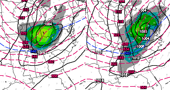
The impact we have from the Wednesday storm is yet to be determined. I doubt we will have a firm grasp on this until later Tuesday or Tuesday night. The NAM went back east, but the GFS is coming west. The American models are simply inferior to models from outside the country.
The Canadian Model continues to hold pretty steady…
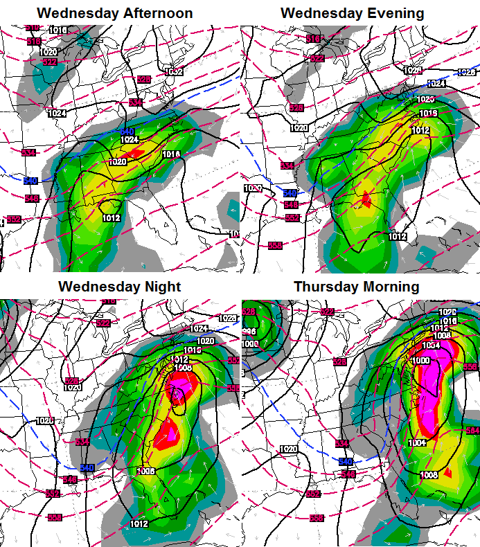
I have no beef with what the Canadian is showing. That’s a solution that makes the most sense as of now. The Short Range Ensemble Forecast model keeps inching westward with the precipitation shield…
The SREF has had a hot hand this winter, so it deserves some respect.
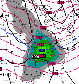
Looking down the road… the Canadian shows a nice clipper diving in to start the weekend…
The same run shows another clipper to end the weekend…
Yep… winter is over. 😉
I will have another update later and will have the latest on the POSSIBLE storm for Wednesday on WKYT-TV starting at 4.

Thanks Chris. See you on the news!
If only we could get temps to cooperate when moisture arrives. Southern KY has not had to deal with the “Brutal” winter as of yet.
wow………you can HAVE our share the rest of this season!!!
Keeping an eye on your blog for great forecasting and conversation. Sunshine making everything bright here in Spencer!
light snow falling in Knox btw so radar rang true this time
I noticed that the Robin’s were back, saw them eating berries in some of my trees, so I do see a warm up coming.
They have been all over my yard the last 2 weeks right
Mine too Andy….Just give me the word Chris and I am a going fishing & camping!!!!! 🙂 🙂
So when they are at your house Andy let me know I’ll get the snow shovel & when they’re at my house we can put the winter coats up!
Robin’s don’t leave this area…this is a myth…I see them every winter around (especially when my holly tree or dogwood tree has any berries or seed pods on them)
True, they are in frankfort every winter all winter!
I have gone by the Robins for years now. I haven’t seen a Robin until this weekend. I go by another sign and that would be the skunks. Over the past two weeks I have seen and smelled them where the either where killed by a vehicle or just walking around. Their matting time usually starts just before the weather starts turning warmer, that’s not saying we are totally finished with snow and cold, but it is a sign that we are turning the corner to warmer weather.
I’m looking forward to the clippers this weekend, here in the Lake Cumberland Area we’ve had our “biggest” dustings of the season from the clippers.
I’m sure this winter still was some tricks up its sleeve, thanks for the updates Chris!
If the south is still getting winter storms I doubt Ky is off the hook for one!
Has 🙂
Good point Todd!
Thanks Chris for the update and reminding the “doubters” to be careful about their forecast sources. You would think after the kid of winter we’ve had so far, they would give up on their doubt. Maybe some things never change…
Thanks for the continued updates! I notice every weather persons forecast is slightly different at this point. We will just have to hide in the weeds and watch what develops with this one. I really appereciate the fact that you approach it from all angles and don’t just say ” this is how it’s going to be!”.
Hope we get a Big SNOW to end the winter with her in Paintsville Ky!! Keep up the good work Chris,best weather Dude ever
SE KY WILL see snow from this storm. u going see a SHARP CUT OFF were there several inches and few miles nothing.
Whitley County’s winter never began. It is like we are not part of Kentucky. We sure aren’t included in any forecast.
all weather sites, wlex, wkyt, wate (Knoxville) showing sunny and 61 for London on Feb 19 and 63 for Feb 20 ……. is winter saying good bye then or just trying pull a fast one on us ?? Chris hasn’t said anything about it, so it makes me wonder if he’s not buying it.
i wasn’t aware that WKYT had a 10 day outlook
shows on my ipad
Are you talking about the wkyt app?
Those apps are computer automated and have no human input at all, it’s probably all the weather apps, as far as I know.
I’m sitting at less than 3 inches total snow for this brutal winter. 60 + degree temps sound good to me. 🙂
choose the grape koolade,Jimmy!
Still hanging with what you think, Mr. Bailey. Thanks for the updates, love to read them!
Hope your wrong and their right for a change Chris. I’m ready for spring…..
Aren’t the “extended” forecast temps/conditions based on past averages?
All apps as Chris stated while back are model data only no matter where they come from
Those extended forecasts are based on models and trends. Accuweather goes out about a month and the temps do not match up with average. Even there forecast is showing more below than above average days in March. I hope it is wrong. I don’t mind a snow in March, but I would much rather see it 70-30 warm days, than the other way around. Last year was about 90-10 cold to warm. No fun at all.
The Euro and Canadian is about the same….Wagon’s westward just a little more and we be in business..
Head’em up…move’em out!
Rawwwww Hideeeee..
Skies are clearing in frankfort so I guess we make another run at zero tonight! If we go below zero that will be the 6th time in frankfort!
Just read the NWS Louisville discussion about the weekend, they are saying by Monday rain with temps in the low 50s, they are jumping out on a limb again, they did not see last night snow until it was falling in frankfort area, I would take their forecast with a grain of salt, Oh, I forgot we are running out of salt 😉
I don’t think it’s too much on a limb. Yes, it’s next week but there are some strong signals that we’ll warm up that’s showing on about all the models. Now I do not think we will see that many 50s or 60s anytime until the end of Feb. But a warm up only to normal standards seems likely (BTW, normal high in Lexington for Feb 10 is 44°, and rises to 50° by the end of the month). Sounds very warm since we’ve been soo cold lately.
Chris has 36 for next Monday, I would say that is much more accurate ;
Atlanta is supposed to mainly get smacked by a crippling ice storm. Surprised the ice word is not popping up here.
thats because the American models are not being given any credit
Are any of the American models showing ice for around here?
Not that i have seen
Well looks like my home town is in for a winter storm in western NC……They have had NO snow this season so far. I remember back in ’94 (still living in western NC) we had the same map with all the watches and warnings currently posted………what ended up happening? We got NOTHING and KY got dumped on with snow. I was so mad.
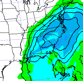
NAM is still showing basically nothing. It has the low going too far east to bring much moisture to this area. The Euro is hammering East KY with 6″ with the GFS somewhere in between. Who do we believe?
Do not be surprised to see the NAM and GFS correct west tomorrow..
As long as not south of the river central Kentucky, it has a chance and not a fantasy 😉 ……. 🙁
Seems to be that the models are 99% always wrong for significant events if we are in the forecast or outlook.
I can’t wait for it to warm up and stop snowing. all these snow days makes it hard for a pre-school teacher to pay bills. I have only worked one full week since the beginning of December. no more snow!
Sun came out and warmed above freezing here in knott co melting what dusting we had
Still quite a bit of snow on my roads here in knott county highest my thermometer read was 29
The people saying Winter is over are likely getting their Forecasts from Global Warming Supporting “The Weather Channel”
The Warming Channel, or AccuWarmer 😉
On a tentative note, CB has not updated in six hours, so perhaps not looking like a Kentucky event? I have not looked at the models today, so just using the CB postometer 🙂
I seen him on an hour ago. Surely you don’t expect this to get in the way of his paying gig do ya?
Post some of the links you use to view the models.
Just watched wymt and their met said good chance for southeastern ky to have snow as everyone has said we will wait and see
Off topic but seem’s like when really cold and wintry weather arrives there’s always a shortage of something..Week ago propane which i know is hogwash and now salt..Greatest Nation on earth taking care of the whole world and can’t keep it’s own people safe..Wonder what happen to all the salt the last 3 yrs when winter decided not to show up..