Good Wednesday, everyone. A big time winter storm is blasting much of the deep south today and will roll up the east coast into Thursday. This is likely to deliver a glancing blow of snow across eastern and southeastern parts of the state. Areas along the Virginia border may pick up several inches of snow.
That’s the area I’m highlighting for a Winter Weather Alert. There is going to be a super sharp cutoff to the accumulating snows on the northwestern side of this storm. The closer you are to Virginia, the better the chance of picking up several inches of wet snow. Here’s a look at the latest snowfall possibilities…
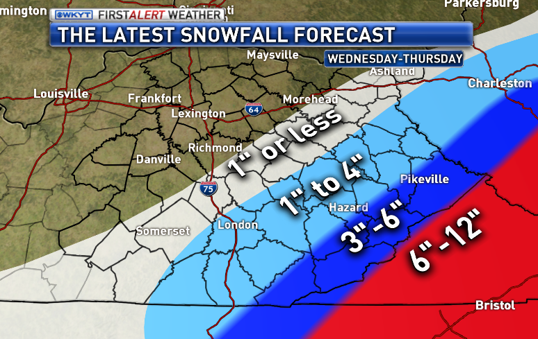 I’m much more confident on the heavier totals in the far southeast than I am of the lighter totals on the northwestern fringe. As I have stated over and over… it all depends on the track of the low and just how far west that snow shield can get. That may be an hour by hour forecast as we watch the radar.
Should I be worried that the GFS now mirrors my forecast?
Expect the snow to break out in the southeast this afternoon and continue through tonight into Thursday morning. Here’s regional radar to help you out…

While we watch this system, we all need to keep watch on a system diving in for Valentine’s Day. I’ve talked about this for a few days and it continues to look like a possible snow maker…
 That thing really digs in here during the afternoon and evening and has the potential to drop some decent snow across the state.
Another system will dive in behind that one late Saturday into early Sunday. That could deliver another round of accumulating snow for some areas.
The good news… we are going to break out of this pattern next week. How about a 60 degree temperature? It’s a possibility at some point before next week is over.
I will have updates coming later today. Take care.

60 one day and crash to 6 the next day? 🙁
Give me 60° & sunshine plz!!!’
Winter storm warning for my neck of the woods. Hopefully we over achieve on this one. JKL calling for 3-5 inches in the warning criteria. Im telling you, if this storm were to jog 50 miles W, it would make a world of difference for a lot of forecasts. Hopefully us snow starved folks in snow starved folks in coal country will get a big one. Thanks again CB for all you do on the blog. It is not required of you, but so many people are thankful for this weather site.
disregard the snow starved typo. lol
storm is much stronger than American models predicted…Foreign models latched on to the potency of the storm several days ago , both GFS and NAM are just now locking in on a solution..and as expected, slight jogs to the west with their snowfall totals..stronger the storm, the more westward trend, extreme southeast KY going to get thumped! Would not be surprised to see counties under winter weather advisories to be upgraded to warnings!
If we dont get more than 2 inches, I give up too! Anyone notice how the NWS just skipped right over one state? Thanks Chris! You are truly appreciated!
Boo to wet snow and no power
the 6z nam model run took a big jog to the nw
They keep calling for it here in middlesboro… The latest radars look as if its going to stay easy of us… So I’m saying a inch if we are lucky!
What you see on radar right now means nothing. The bulk of precipitation doesn’t arrive until early evening though the night….
How about 70°? That’s what the Euro is showing! Enjoy the snow this morning for people with a snowpack. Most of it will melt today and tomorrow, if not, then all the snow will be gone by before our next system. CB saw the warm up all along but just didn’t mention it until later.
In regards to next week’s warm up, wasn’t the phrase “be very careful where you get your weather info” related to another met talking last week about the huge warming trend. It may have been something else, but it seemed around the same time frame.
that’s exactly what was said and I mentioned a week ago that accuweather had this warm up and got dogged by some saying accuweather was never correct – well looks like they are going to nail this one.
Even a blind squirrel can find a nut LoL 😉
and that wasn’t a dig on you Jim
You should do stand up
Accuweather is the worst!
Actually, I did not get my info (the warm up) from a met at all. I heard others were saying it and didnt buy into it either but I said it myself with the models and looking at the pattern. I dont just buy into anythIng any met says, I’m not as easily influenced as you might think. I’m VERY careful where I get my sources from. The point is my source was myself and I saw this pattern evolving several days ago.
CB is one of the best mets and in no way was I trying to bash on him in any way. he’s really good met, and way better than others I’ve seen. All I was stating was that I KNOW cb saw the warm up coming but he just said it later in the game. My apologies if anyone was offended.
A lot of mets were talking warm up early next week. If only it would fall on the weekends.
They keep saying it will continue on the Westard track still today. Middlesboro is going to get 5-7″ before it’s all said and done.
That’s a lot of pink on the radar sliding north into Southern Kentucky right now. Stay where you belong in TN.
its harmless nothing reaching the ground atm Temp is at 25 atm
Anyone know if what the radar is showing is actually hitting the ground?
not in Knox atm kids are still in school they miss for flurries 😉
Not yet in Middlesboro or in Harrogate,TN
It is in Chattanooga and accumulating according to reports before the warning started so IMO its either moving faster or moving more NW than expected
Interesting 🙂
Snowing here in Athens halfway between Knoxville and Chattanooga…4-8+ expected in this area
boo 😉
I really do hope a warm up happens. I will NOT complain………I’m so sick of cold and the snow pack can be gone already. It’s been on the ground for a LONG time it seems……..
If a warmup does happen, the naysayers will come out of the woodwork to poke at Chris with their usual bollocks. On the other hand, I would just be happy to see warmer air. 😉
Blowtorch March. You heard it here first
hahaha gotta love it Bryant – eventually you’ll hit it 🙂
I feel like, in some ways, we hit here in good ole London. Take a drive north to Lexington, Frankfort and Louisville-whole different scenery. It’s like I went from the south to Minnesota in one hour. We’ve had our share of cold weather, but a fraction of the snow.
Your awesome Bryant. I am so ready my brother and right there with you. I wish I had a blowtorch for the ice on my driveway and porch. This ice is getting rediculous. I really feel for the people in the deep south that are expecting ice. I just heard on the radio that they are calling for the potential of an inch of ice and it could be catastrophic.
Thanks Ben, glad to see you enjoy my odd sense of humor. I thought for sure I would get blasted by a few after my blowtorch comment. It’s all in good fun.
my stepbrother lives suburban Atlanta and he said it is like a ghost town right now – said ice already falling and power starting to go out in places. thankful to be here !!
Bryant if you are right, I will buy you a beer!
AMEN! My pipes are frozen again and I’d like to get up my driveway before March.
Still nothing hitting the ground in Knox
Let us know when it starts Andy!
Will do
Still holding out hope that Wayne County can get in on some snow love from this. I notice we’re on the line again in terms of chances. McCreary County schools are dismissing at 11:30 today…are they seeing something headed this way or just being trigger happy?
Always better to be safe than sorry IMO. I hope you get dumped on Mr Fife
Anybody planting any peas this valentine’s day..
as expected DRY air will win out for a ;ONG TIME, don’t see deeper moisture reaching here till late this evening at best.
Wasn’t supposed to be til this evening anyway….
You spoiled the surprise
Thanks Chris for giving us a hopeful glance of 60 degree weather next week. I always have loved the winter months, but now I am ready for some warm temperatures!!!!
some one please correct me if i am wrong or my eyes are decieving me but it appears the center of low pressure is in south west part of alabama and not moving across florida as some thought it might do…….could this turn out being an appy runner? hhhhhuuuuummmmm!
I was thinking th same and I’d love to hear someone’s take on this!
The ole weather channel is trying to bring enough warm air north for a mix in KY Friday? Chris is going with mostly snow so One more nice little snow would be fine then on to the 60s!
Posted wrong area 🙂
Well ,I’m looking at the radar sort of focusing on western NC since that’s where I’m orig from………..and it sure looks like a pitiful radar for heavy snow that’s forecast…….It looks to me like the heavies precip is in SC……..Unless what’s back in TN blows up and moves over the western NC area………I dunno. I wonder if the deep south heavy rains south of there is robbing some of the moisture? I know that has happened to us before……..I could be totally wrong. I know nothing about forecasting……
Looking at the cloud cover on radar it looks like it is coming straight north. Don’t know if that means anything or not. Just an observation.
Radar is starting to fill in big time now.
Dodger says a big snow storm would be nice. Don’t understand some on here who seem to “worship” other posters who write stupid stuff. Dodger!
Lame^
In Madison county I have learned that if you never expect anything you are never disappointed. … Big ones to the north, south, east and west…
folks by 2-3 pm the snow should start hammering. the air is getting moist.
in the farrrrrr SE counties on border that is..
Just now starting in knox