Good evening, everyone. A Winter Storm WATCH has been issued for far southeastern Kentucky from later Wednesday into the first part of Thursday. Here’s a look…
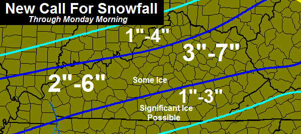
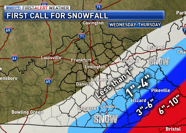
That will likely get reworked later tonight or into early Wednesday as the track of the storm becomes more clear. It’s a headache to try to pinpoint snowfall amounts for a system that still has some wiggle room. Here’s a first call…
Why am I leaving myself a lot of wiggle room with totals? Because of models like the late afternoon run of the short range Canadian…
It’s all about the track of the low. If it comes a bit to the west, then the totals get pushed west and higher. If it goes a bit east… you know the drill.
The prime time for this to impact our weather will be late Wednesday afternoon into Thursday morning.
Enjoy the evening and take care.

I like this forecast for Lawrenceburg. No ice, no snow, no rain. Hopefully another mostly sunny day?
can’t hate on a sunny day only dry cold or wet cold days 🙂
Thanks Chris. Hoping this pans out with a nice snowfall and then a fast forward to an early Spring!
As maxwell smart would say” It Only missed by that much” big snows to the north, west and now the south, is central ky jinxed?
doesnt this mean the euro and canadian are both starting to bring this the nw a bit??
Soooooooo you’re saying there’s a chance??????
– Dumb & Dumber
Here is what Bastardi thinks if your interested
Very Warm water off the east coast will supply extra energy for storm help with the more west track we have had
What does the red on this map signify?
which one map 1 2 or 3
The short term Canadian that cb said was the reason he left wiggle room
No clue then sorry
Here in the Belfry area of Pike County we are so close to getting our best snow of the season. Gonna be keeping my eyes on the latest runs of the models for sure. Please go west!!
Thanks Chris so much.I really would love to see us get a good one.That would be a sight for my sore eye lol.I guess we will all find out together.Last time I checked my sis in law in Richlands Va is set to really get it 6-10 inches or more and she doesn’t want it.I told her me Andy and Coffee and a few others would take it.
NAM continues to hold onto the storm for eastern Kentucky.
Do you have a link Dale?
No just reading it as it comes out.
Link?
Extreme eastern ky
If the coating to 2 inches work out for my area (KNOX) like WYMT is predicting then that will mean areas North, South, and East of me are all going to have more snowfall than me this year. Think you western Kentucky in sharing our low totals with us this year. lol
On a serious note, I don’t like how no one is jumping on the famous NW shift bandwagon. Weather.com has us at less than 1 inch. NWS Jackson basically the same. Even CB is a little hesitant to bring the bigger snow lines past extreme southeast Kentucky. Maybe a surprise will hit, but this thing is pretty close to showtime.
i think it has been showing signs of it …but slowwwwwwwly
According to CBs tweet the NAM obviously didn’t say BAM. This thing is getting close and no one really wanting to jump on this thing coming very far into Kentucky. If this one doesn’t hit we obviously didn’t get enough of the famous NW shift that has become the norm when a storm is sitting in the right place 3 or 4 days out.
NAM did not say BAM for a few other systems this winter and ended up being correct. Not saying that will be here, but point still is the NAM was correct a few other times in similarly short windows.
True, but i would need 2 hands to count the number of different mets over the past week who have said to completely disregard the NAM for any “southern track storm” because it almost useless to nail down any degree of accuracy….
Good point. Will the NAM get a SLAM?
lol. At this point , who knows!
Bobt I have talking about the northwest shift ever since the first storm back in early Dec. Every storm has shifted to the northwest the day of the storm. Lexington May see a couple inches out of this when it is all said and done. I have mentioned several times over the past couple days that southeastern kentucky will have heavy snow.
Not long to find out. Seems a mainly south east event. I think CBs map above is a best case scenario, but JMO of course.
Geez relax guys…..This storm is at least 12 – 18 hours away from our neck of the woods! Wait and see, this is still up in the air 🙂
Literally 🙂
Knoxville station is showing 6.7″ for them per NAM. He said it’s def showing a more westward track.
Again, a little bit of a western track is needed to get CBs map totals above. That is not an eastern track for that map. It would not hardly touch KY if it were.
Yada, yada, yada….talking heads and peanut gallery
This is a blog/forum and not a fan site 😉 if no chatter and discussion, CB does not need the forum and just a web page.
Yada, yada, yada. Now you have me thinking about Seinfeld.
lol…Well all you’s can say is instead of the famous NW shift is we got shafted..
Appears so, but at least we are not getting the potentially catastrophic ice storm.
I guess another way too look at it is this will probably be a heavy wet snow for Tenn..Power outages galore..With the ice farther south and wet snow for other’s who know’s how long you will be without power..My kinda weather..
Hey Andy..Why not drive down to the Tenn. border and watch a real snow..Apparently the good one’s avoid Ky like the plague..Wonder why..
They “only” avoid the central, south central part. They literally happen all directions around this area. Uncanny.
If it snowed 40 inches tonight in your back yard, you would be on here every day saying, “All but that one time in the last 15 years….”
That is based on false pretense since has not done that nor has so in recorded history….
Beth I hear you callin’, but I can’t come home right now…
So, you are using your favorite word “semantics” on this one. Nice.
I live just south of Asheville, NC and the latest runs have us @ 12in.+ for tomorrow and Thur. This storm will hit us hard but by Friday we will be back around 50 and it will melt……that’s what I call a perfect storm.
This is one cool radar..Look how it draw’s the moisture from the Atlantic..Of course if it was Gulf moisture our low would of took a NW shift and would be in Michigan by now..lol
http://hp6.wright-weather.com/wrf_nmmeast-radar-loop_1hour.gif